Morocco — Marrakech
Hike Morocco's Tizi nTichka to Telouet Kasbah, a 25km moderate walk through the Atlas Mountains. This historic route follows ancient caravan trails, transitioning from alpine highlands to arid southern valleys. Expect varied terrain, from mountain passes to sun-drenched plains, offering a profound glimpse into Morocco's past. Allow 6-8 hours for this evocative day walk.
Distance: 25.0 km
Elevation Gain: 800 m
Difficulty: Moderate
Duration: 6-8 hours
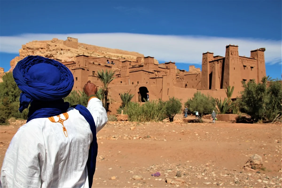
The trek from the Tizi nTichka pass to the Kasbah of Telouet is one of Morocco's most evocative day walks, offering a profound transition from the high-altitude alpine environment of the Atlas Mountains to the arid, sun-drenched valleys of the south. Spanning approximately 25 kilometres, this route follows the ancient caravan trails that once connected the sub-Saharan trade routes with the imperial cities of the north. It is a journey through time as much as landscape, leading walkers away from the modern tarmac of the national road and into a world of terraced fields, traditional Amazigh (Berber) villages, and crumbling architectural masterpieces. The destination, the Kasbah of Telouet, stands as a haunting monument to the power and eventual fall of the Glaoui family, the "Lords of the Atlas," who once controlled the very ground you walk upon.
The Tizi nTichka to Telouet walk is a masterclass in geological and cultural contrast. Starting at the summit of the Tizi nTichka pass—the highest major mountain pass in North Africa—the trail immediately leaves the roar of the Marrakech-Ouarzazate highway behind. The initial stages of the walk are characterised by high-altitude plateaus and ridges where the air is thin and crisp, and the vegetation is limited to hardy alpine scrub and scattered juniper trees. From these heights, walkers are treated to panoramic views of the High Atlas peaks, which remain snow-capped well into the spring, providing a stark white contrast to the deep ochre and terracotta hues of the valley floors below.
As the trail descends towards the Ounila Valley, the landscape undergoes a dramatic transformation. The rugged grey limestone of the high peaks gives way to softer red sandstone and green marl. The path winds through a series of small, remote villages where life continues much as it has for centuries. Here, the ingenuity of the local Amazigh people is on full display: intricate irrigation systems (seguias) channel snowmelt from the heights to nourish narrow strips of emerald-green terraces filled with barley, almond trees, and walnut groves. The contrast between the barren, sun-scorched hillsides and these lush, cultivated ribbons of green is one of the most striking features of the Moroccan mountain landscape.
The final approach to Telouet is dominated by the sight of the Kasbah itself, a massive, decaying fortress that seems to grow directly out of the earth. Unlike the more famous and restored Ait Benhaddou further down the valley, Telouet remains in a state of "magnificent decay." The walk concludes at the gates of this former palace, offering a sense of arrival that few day hikes can match. This is not merely a physical challenge; it is an immersion into the "Deep South" of Morocco, where the scale of the mountains and the weight of history combine to create a truly unforgettable experience.
The history of this trail is inextricably linked to the salt trade and the rise of the Glaoui clan. For centuries, the route between Telouet and the Tizi nTichka pass was a vital artery for caravans carrying salt, gold, and slaves from Timbuktu to the markets of Marrakech. The Glaoui family, originally a minor Berber tribe, rose to prominence in the late 19th century by seizing control of this strategic pass and the nearby salt mines. By the early 20th century, Thami El Glaoui, the Pasha of Marrakech, had become one of the wealthiest and most powerful men in the world, often referred to as the "Lord of the Atlas."
The Kasbah of Telouet was the family's ancestral seat and the base of their power. At its height, the palace was a sprawling complex of over 300 rooms, decorated with the finest zellij (mosaic tilework), carved cedarwood, and intricate stucco. It was here that the Glaouis hosted international dignitaries, French generals, and even Winston Churchill. However, the family's decision to support the French colonial administration against the Moroccan nationalist movement led to their downfall. Following Morocco's independence in 1956, Thami El Glaoui was declared a traitor, his properties were seized, and the Kasbah was left to the mercy of the elements. Today, walking through the crumbling corridors of Telouet provides a poignant look at the transience of power.
Beyond the political history, the trail passes through the heartland of the Amazigh people. The villages you encounter—such as Aguelmouss and Anmiter—are inhabited by communities that have maintained their language, traditions, and architectural styles for millennia. The houses are built from "pisé" (rammed earth), a sustainable material that provides excellent insulation against the extreme temperatures of the Atlas. Understanding the resilience of these mountain communities, who have survived through centuries of dynastic shifts and colonial rule, adds a layer of profound respect to the walking experience.
Want more background? Read extended notes on history and cultural context → Learn more
The High Atlas is a land of extremes, and timing your walk is crucial for both safety and enjoyment. Because the trail starts at over 2,200 metres and descends into an arid valley, you must be prepared for a wide range of temperatures in a single day.
Spring (April to May): This is arguably the best time to undertake the walk. The high peaks are still draped in snow, providing a spectacular backdrop, while the valleys are in full bloom. The almond and cherry blossoms in the villages of the Ounila Valley create a soft, fragrant atmosphere, and the temperatures are generally mild (15–25°C). However, spring can also bring unpredictable mountain storms and high water levels in the river crossings.
Autumn (September to October): Another excellent window. The intense heat of the summer has faded, and the air is often exceptionally clear, offering the best long-distance views. This is the harvest season, and you will likely see villagers busy gathering walnuts and drying peppers on their rooftops. Temperatures are similar to spring, though the landscape is much drier and the colours more muted and earthy.
Winter (November to March): Walking this route in winter is a serious undertaking. The Tizi nTichka pass frequently sees heavy snowfall, which can close the road from Marrakech and make the initial sections of the trail impassable without snowshoes or crampons. Temperatures at the pass can drop well below freezing, and while the valley floor may be sunny, the wind chill on the ridges can be dangerous. Only experienced winter hikers with appropriate gear should attempt this during these months.
Summer (June to August): While the high pass remains relatively cool, the descent into the Telouet valley can be punishing. Temperatures often exceed 35°C, and there is very little shade on the trail. The risk of heatstroke and dehydration is high. If you must walk in summer, an extremely early start (before dawn) is essential, and you must carry significantly more water than usual.
Early Morning: Marrakech to the Pass
Morning: The High Plateau Descent
Midday: The Village Trail
Afternoon: The Approach to Telouet
Late Afternoon: Exploration and Return
Important Notes:
The primary logistical challenge for this walk is the point-to-point nature of the route. You will start at the Tizi nTichka pass and finish in Telouet, which is approximately 20 kilometres away by road from the pass. You must arrange for a driver to drop you at the pass and meet you in Telouet in the afternoon. Most hikers organise this through a tour agency in Marrakech or by negotiating a day rate with a Grand Taxi driver.
In terms of fitness, while the walk is mostly downhill or flat, the 25-kilometre distance on rocky, uneven terrain is taxing. You should be comfortable walking for 7–8 hours in potentially warm conditions. Acclimatisation is generally not an issue for a day walk at these altitudes, but you may feel the effects of the thinner air during the first few kilometres at the pass.
Marrakech is the best base for this trip. It offers a wide range of accommodation and is the hub for all transport heading into the Atlas. Ensure you have enough Moroccan Dirhams (MAD) in cash, as there are no ATMs in the mountains or in Telouet village.
This is primarily a day hike, and most walkers return to Marrakech or continue to Ouarzazate in the evening. However, staying overnight in the region allows for a more relaxed pace and a deeper cultural experience.
In Telouet: There are several traditional guesthouses (Gîtes d'étape) in the village. These offer simple but clean rooms, often with shared bathrooms. They provide an authentic experience, including home-cooked Moroccan meals (tagines and couscous). Prices are generally very reasonable, typically ranging from 200 to 400 MAD per person including dinner and breakfast.
On the Trail: There is no formal accommodation between the Tizi nTichka pass and Telouet. Wild camping is technically possible but not recommended due to the proximity of villages and the lack of flat, sheltered sites. If you wish to turn this into a multi-day trek, you would typically continue down the Ounila Valley towards Ait Benhaddou, staying in village guesthouses along the way.
Facilities: Do not expect luxury. Guesthouses in the Atlas are functional. Hot water is usually available but can be temperamental. WiFi is rare and mobile signal is patchy throughout the valley.
Currently, no official permits are required from the Moroccan government to walk the route from Tizi nTichka to Telouet. The trail follows public rights of way and traditional mule tracks. However, there are several practical considerations regarding access and local regulations.
Guide Requirements: While not legally mandatory, the Moroccan authorities strongly recommend that foreign hikers employ a certified mountain guide. This is particularly true following the implementation of stricter safety protocols in the High Atlas in recent years. A guide not only assists with navigation but also acts as a cultural bridge, facilitating interactions with local villagers and ensuring you stay on the correct paths. If you choose to walk without a guide, you may be stopped by the Royal Gendarmerie at checkpoints on the road to the pass; they will often ask for your itinerary and may discourage solo hiking for safety reasons.
Kasbah Entry: The Kasbah of Telouet is privately managed by the descendants of the Glaoui family. There is a small entry fee (usually around 20–30 MAD) which goes towards the basic maintenance of the site. Ensure you have exact change. The Kasbah is generally open from 08:00 until sunset.
Checkpoints: When travelling by road to the trailhead, you will likely pass through several police or gendarmerie checkpoints. Always have your passport (or a high-quality photocopy) easily accessible. It is common practice for drivers to provide a "fiche" (a simple form with your passport details) to the police to speed up the process.

Detailed route notes, maps, logistics & tips for the Tizi N Tichka To Telouet (PDF).

Precisely traced GPX for the Tizi N Tichka To Telouet, ready for your GPS or favourite mapping app.
The region surrounding the Tizi nTichka pass and the Ounila Valley is rich with opportunities for further exploration:
Weather and Exposure: The most significant risk on this trail is the weather. The High Atlas can experience violent thunderstorms, even in summer. These storms can lead to flash floods in the narrow valleys (wadis). If the sky turns dark and you hear thunder, move to higher ground immediately and avoid crossing riverbeds. Additionally, the sun at 2,000 metres is incredibly intense; heat exhaustion can set in quickly if you are not properly hydrated and covered.
Altitude: While 2,260 metres is not high enough to cause severe altitude sickness for most people, you may experience shortness of breath or a mild headache. Listen to your body, walk at a steady pace, and drink plenty of water. If symptoms persist or worsen, descend to a lower altitude immediately.
Terrain and Navigation: The trail is often rocky and can be slippery, especially after rain. Good footwear is non-negotiable. Navigation can be complex in the lower valley where many small paths lead to private fields or different parts of a village. Using a GPS app with offline maps (like Gaia GPS or AllTrails) is essential if you do not have a guide. Be aware that mobile signal is non-existent in many sections of the trail.
Local Wildlife: You are unlikely to encounter dangerous animals. Scorpions and snakes exist but are rarely seen during the day and generally avoid human contact. The most common "wildlife" issue is aggressive village dogs; usually, a firm shout or the motion of picking up a stone is enough to deter them, but it is best to stay on the main paths and avoid walking through villages after dark.
Emergency Services: There is no formal mountain rescue service in Morocco. In the event of an emergency, your first point of contact should be your guide or the local Gendarmerie in Telouet or at the Tizi nTichka pass. Ensure you have comprehensive travel insurance that specifically covers "hiking up to 3,000 metres" and includes emergency evacuation.
The Reception Rooms of Telouet: While much of the Kasbah is in ruins, the interior reception rooms are a stunning exception. These rooms were completed just before the Glaoui family's fall and represent the pinnacle of Moroccan craftsmanship. The contrast between the crumbling, mud-brick exterior and the explosion of colour and intricate detail inside—featuring Italian marble, gold leaf, and exquisite zellij—is breathtaking. It is worth spending at least an hour here with a local site guide who can explain the symbolism of the patterns.
The Anmiter Terraces: As you pass through the village of Anmiter, take the time to look at the complex system of stone-walled terraces. These are a marvel of traditional engineering, allowing the villagers to farm on incredibly steep slopes. The way the water is shared between families using a timed system of opening and closing small dams is a fascinating example of community resource management.
The Tizi nTichka Viewpoints: Before you start your walk, explore the area immediately around the pass. There are several short paths leading to ridges that offer views both north towards the Haouz Plain and south towards the pre-Saharan steppes. On a clear day, the sense of being on the "spine" of Morocco is palpable.
Local Salt Workshops: In Telouet village, you can often find small workshops where the locally mined salt is processed or sold. The salt is famous for its purity and mineral content. Buying a small bag is a great way to support the local economy and take home a piece of the mountain's history.
The High Atlas is a fragile ecosystem and the home of communities that rely directly on the land. As a visitor, it is your responsibility to minimise your impact and show respect for the local culture.
Environmental Responsibility:
Cultural Respect: