Tilicho Lake Trek - Nepal's High-Altitude Gem
The Tilicho Lake Trek is an exhilarating journey through the Annapurna region of Nepal, culminating at the breathtaking Tilicho Lake, one of the highest altitude lakes in the world. This trek offers a spectacular blend of diverse landscapes, from lush rhododendron forests and terraced fields to arid, windswept high-altitude deserts and snow-capped peaks. It's a challenging yet immensely rewarding adventure that provides a unique perspective on the Himalayas, far from the more crowded routes.
- Distance: Approximately 55 km (main route)
- Duration: 8-10 days
- Season: March-May and September-November
- Highest point: Tilicho Lake (4,919 m)
- Difficulty: Challenging
- Starting Point: Besisahar (via Kathmandu)
- Ending Point: Jomsom (via Thorong Phedi/High Camp)
- Permits: Annapurna Conservation Area Permit (ACAP) and TIMS card required
Overview
The Tilicho Lake Trek is a captivating exploration of the Annapurna Conservation Area, renowned for its dramatic scenery and cultural richness. Unlike many treks that focus solely on Everest or Annapurna Base Camp, this route offers a distinct experience by leading trekkers to the awe-inspiring Tilicho Lake, situated at a staggering 4,919 metres above sea level. The trek typically begins in Besisahar, the gateway to the Annapurna region, and winds its way through traditional Gurung and Manangi villages, offering glimpses into the lives of the local people. As the altitude increases, the vegetation changes from subtropical forests to alpine meadows and eventually to a stark, high-altitude desert reminiscent of Tibet.
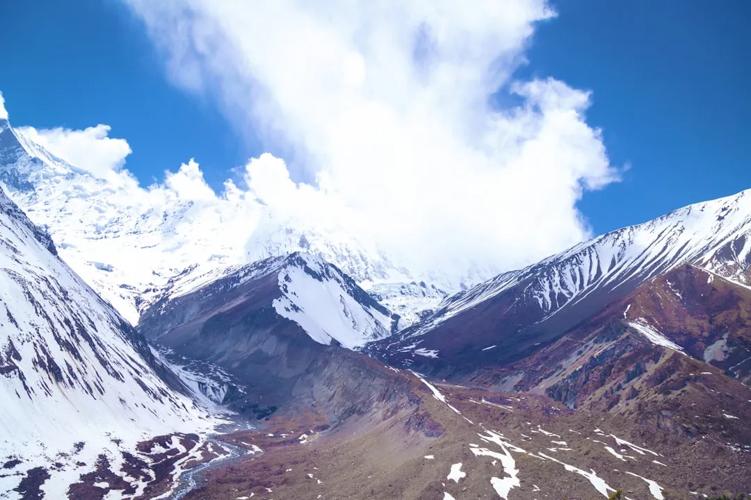
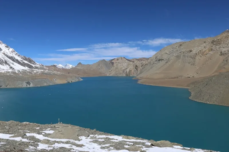
The trek's highlight is undoubtedly Tilicho Lake itself. Nestled beneath the towering peaks of Annapurna and Dhaulagiri, the lake's turquoise waters, often reflecting the surrounding snow-capped giants, create a scene of unparalleled beauty. The journey to the lake involves navigating challenging terrain, including steep ascents and descents, and acclimatising to the extreme altitude. Beyond Tilicho Lake, the trek often continues over the formidable Thorong La Pass (5,416 m), one of the highest trekking passes in the world, before descending into the Mustang region and the town of Jomsom.
This trek is suitable for experienced trekkers who are comfortable with high altitudes and challenging conditions. The remoteness and ruggedness of the terrain, combined with the sheer scale of the Himalayan vistas, make the Tilicho Lake Trek an unforgettable adventure for those seeking a true wilderness experience in Nepal.
History and Cultural Context
The Annapurna region, including the areas traversed by the Tilicho Lake Trek, has a long history of human habitation and trade. For centuries, these mountain passes served as vital routes for salt traders and pilgrims travelling between Tibet and the lower valleys of Nepal. The Manangi people, who inhabit the villages along the trek, have a rich cultural heritage deeply intertwined with Tibetan Buddhism and a long tradition of trade and migration.
The discovery and popularisation of Tilicho Lake as a trekking destination is a more recent phenomenon. While local communities have always known of the lake, its accessibility to international trekkers began to grow with the development of trekking infrastructure in Nepal. The trek gained prominence as an alternative to more established routes, offering a unique challenge and the allure of reaching one of the world's highest lakes. The construction of a road from Besisahar towards Manang has altered the traditional trekking experience, making certain sections more accessible by jeep, but the core spirit of adventure and the challenging nature of the higher altitudes remain.
The region is part of the Annapurna Conservation Area Project (ACAP), established in 1992. ACAP is the first and largest conservation area in Nepal, aiming to conserve the natural environment and promote sustainable tourism while involving local communities in conservation efforts. This initiative has played a crucial role in preserving the unique biodiversity and cultural heritage of the Annapurna region, ensuring that treks like the Tilicho Lake journey can continue to be enjoyed responsibly.
Seasonal Highlights and Weather Reality
The Tilicho Lake Trek is best undertaken during the spring (March-May) and autumn (September-November) seasons. These periods offer the most favourable weather conditions for high-altitude trekking.
Spring (March-May): This season marks the end of winter and the beginning of warmer weather. Rhododendron forests, Nepal's national flower, are in full bloom, painting the lower hillsides with vibrant colours. Temperatures gradually rise, making trekking more comfortable. However, late spring can sometimes bring pre-monsoon showers, which can affect visibility and trail conditions. The skies are generally clear, offering excellent mountain views.
Autumn (September-November): This is widely considered the prime trekking season in Nepal. After the monsoon rains, the air becomes crisp and clear, offering unparalleled panoramic views of the Himalayas. The skies are typically blue, and the weather is stable, with moderate temperatures. This season is ideal for photography and for enjoying the majestic mountain scenery without the haze of summer or the cold of winter.
Monsoon (June-August): The summer months are characterised by heavy rainfall, especially in the lower altitudes. This can lead to landslides, making some trails impassable and increasing the risk of leeches and muddy conditions. While higher altitudes might experience less rain, visibility is often poor, and mountain views are obscured by clouds. This season is generally not recommended for the Tilicho Lake Trek.
Winter (December-February): Winters in the Annapurna region can be extremely cold, with heavy snowfall at higher elevations. The Thorong La Pass and the route to Tilicho Lake can become impassable due to snow and ice. While lower sections might be trekkable, the extreme cold and potential for blizzards make this season challenging and potentially dangerous for this particular trek. Only experienced winter trekkers with appropriate gear should consider attempting parts of the trek during this time.
Recommended Itinerary
8-Day Tilicho Lake Trek Itinerary (Sample)
Day 1: Arrival in Kathmandu and Preparation
- Arrive at Tribhuvan International Airport (KTM), Kathmandu.
- Transfer to your hotel.
- Obtain necessary permits (ACAP and TIMS card) and finalise trek arrangements.
- Explore Kathmandu's cultural sites if time permits.
Day 2: Kathmandu to Besisahar to Khudi/Bhulbhule
- Morning bus or private jeep from Kathmandu to Besisahar (approx. 6-7 hours).
- Continue by jeep from Besisahar to Bulbule (approx. 2 hours, rough road).
- Begin trekking from Bulbule or Khudi.
- Distance: Approx. 5-10 km trekking after jeep ride.
- Elevation Gain: Gradual ascent.
- Time: 2-3 hours trekking.
- Overnight at a teahouse in Khudi or Bulbule.
Day 3: Khudi/Bhulbhule to Ghermu/Syangge
- Trek through lush forests and terraced fields.
- Cross suspension bridges over the Marsyangdi River.
- Pass through small villages and observe local life.
- Distance: Approx. 15-20 km.
- Elevation Gain: Moderate ascent.
- Time: 5-7 hours.
- Overnight at a teahouse in Ghermu or Syangge.
Day 4: Syangge to Dharapani
- The trail becomes steeper as you ascend towards the Manang district.
- Pass through beautiful waterfalls and dramatic gorges.
- Enter the Annapurna Conservation Area.
- Distance: Approx. 15-18 km.
- Elevation Gain: Significant ascent.
- Time: 6-8 hours.
- Overnight at a teahouse in Dharapani.
Day 5: Dharapani to Chame
- Trek through pine and rhododendron forests.
- Enjoy increasingly spectacular mountain views, including Annapurna II and Lamjung Himal.
- Chame is the administrative centre of the Manang district.
- Distance: Approx. 15 km.
- Elevation Gain: Moderate ascent.
- Time: 5-6 hours.
- Overnight at a teahouse in Chame.
Day 6: Chame to Pisang
- The valley widens, offering stunning views of Annapurna and Pisang Peak.
- Pass through traditional villages with Tibetan influences.
- Distance: Approx. 14 km.
- Elevation Gain: Moderate ascent.
- Time: 5-6 hours.
- Overnight at a teahouse in Pisang.
Day 7: Pisang to Manang
- Choose between the lower route via Hongde or the upper route via Ghyaru and Ngawal for more dramatic views.
- The upper route offers breathtaking vistas of Annapurna III, IV, and Gangapurna.
- Manang is a large village with a rich cultural heritage.
- Distance: Approx. 17 km (upper route).
- Elevation Gain: Significant ascent.
- Time: 7-9 hours (upper route).
- Overnight at a teahouse in Manang.
Day 8: Acclimatisation Day in Manang
- Rest and acclimatise to the altitude (3,540 m).
- Optional short hikes to viewpoints like Gangapurna Lake or Praken Gompa.
- This day is crucial for preventing altitude sickness before ascending further.
- Time: Flexible.
- Overnight at a teahouse in Manang.
Day 9: Manang to Khangsar
- Trek towards the remote Khangsar village, the last settlement before Tilicho Lake.
- The landscape becomes more arid and rugged.
- Distance: Approx. 10 km.
- Elevation Gain: Moderate ascent.
- Time: 4-5 hours.
- Overnight at a teahouse in Khangsar.
Day 10: Khangsar to Tilicho Base Camp
- A challenging day of trekking towards the base camp of Tilicho Lake.
- The trail involves steep ascents and traverses across scree slopes.
- Distance: Approx. 8-10 km.
- Elevation Gain: Significant ascent.
- Time: 5-7 hours.
- Overnight at a basic teahouse or lodge at Tilicho Base Camp (4,150 m).
Day 11: Tilicho Lake Excursion and Return to Base Camp/Shrine Camp
- Early morning hike to Tilicho Lake (4,919 m).
- Spend time admiring the stunning lake and surrounding peaks.
- Return to Base Camp or descend further to Shrine Camp for a slightly lower altitude.
- Distance: Approx. 6-8 km round trip to lake.
- Elevation Gain: Steep ascent to lake, then descent.
- Time: 6-8 hours total.
- Overnight at a teahouse at Base Camp or Shrine Camp.
Day 12: Shrine Camp to Yak Kharka
- Continue trekking through the high-altitude desert landscape.
- The trail gradually ascends towards Yak Kharka.
- Distance: Approx. 10-12 km.
- Elevation Gain: Moderate ascent.
- Time: 4-6 hours.
- Overnight at a teahouse in Yak Kharka.
Day 13: Yak Kharka to Thorong Phedi/High Camp
- Trek to Thorong Phedi (4,450 m) or continue to High Camp (4,925 m) for an earlier start to the pass the next day.
- The terrain is rocky and barren.
- Distance: Approx. 7-9 km.
- Elevation Gain: Significant ascent.
- Time: 4-6 hours to Phedi, 6-8 hours to High Camp.
- Overnight at a teahouse in Thorong Phedi or High Camp.
Day 14: Thorong Phedi/High Camp to Muktinath via Thorong La Pass
- The most challenging day, crossing the Thorong La Pass (5,416 m).
- Begin early morning to avoid strong winds.
- Descend steeply to Muktinath, a sacred pilgrimage site for Hindus and Buddhists.
- Distance: Approx. 16 km.
- Elevation Gain: 1,000 m ascent to pass, 1,500 m descent.
- Time: 8-10 hours.
- Overnight at a teahouse in Muktinath.
Day 15: Muktinath to Jomsom
- Explore the sacred temples and monasteries of Muktinath.
- Trek down to Jomsom, a large town in the Kali Gandaki Valley.
- The trail follows the Kali Gandaki River, known for its strong winds.
- Distance: Approx. 18 km.
- Elevation Loss: Significant descent.
- Time: 5-7 hours.
- Overnight at a teahouse in Jomsom.
Day 16: Fly from Jomsom to Pokhara
- Morning flight from Jomsom to Pokhara (weather permitting).
- Enjoy the scenic flight over the Himalayas and the Kali Gandaki Gorge.
- Transfer to your hotel in Pokhara.
- Time: Approx. 25 minutes flight.
- Overnight in Pokhara.
Day 17: Departure from Pokhara
- Enjoy Pokhara's lakeside attractions or depart for Kathmandu.
- Bus or flight from Pokhara to Kathmandu.
- Overnight in Kathmandu or depart from KTM.
Note: This is a sample itinerary and can be adjusted based on fitness levels, acclimatisation, and available time. Some trekkers opt for a longer duration to allow for more acclimatisation days or to explore side valleys.
Planning and Bookings
Book Your Trip
Everything you need to plan your journey
Accommodation
Find places to stay near Pokhara
Flights
Search flights to Pokhara
Essential Preparation
The Tilicho Lake Trek is a challenging high-altitude trek that requires careful planning and preparation. Given its remote location and the extreme altitudes involved, physical fitness is paramount. Trekkers should engage in regular cardiovascular exercise, including hiking with a weighted backpack, for several months leading up to the trek. This will help build stamina and prepare the body for long days of walking at altitude.
Logistics: The trek typically starts from Besisahar, which is accessible from Kathmandu. You will need to arrange transportation from Kathmandu to Besisahar, and then potentially a jeep further up the road towards Bulbule or Khudi. Accommodation along the trek is in teahouses, which are basic lodges offering rooms and meals. It is advisable to book these in advance, especially during peak seasons, though flexibility is often required due to the nature of trekking.
Base Town/City Information:
- Kathmandu: The capital city and primary international gateway to Nepal. It's where you'll obtain permits, hire guides and porters if needed, and make final preparations. Kathmandu offers a wide range of accommodation, from budget guesthouses to luxury hotels.
- Besisahar: The starting point for many Annapurna region treks. It's a bustling town with basic facilities, including teahouses, restaurants, and shops.
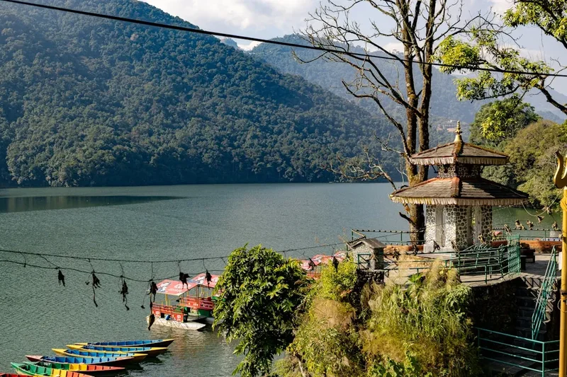
- Pokhara: A beautiful lakeside city that serves as the gateway to the Annapurna region. It's a popular tourist destination with excellent accommodation, dining, and adventure activity options. Many trekkers spend a day or two here before or after their trek.
Trail Accommodation
Accommodation along the Tilicho Lake Trek is primarily in teahouses, which are simple lodges run by local families. These offer basic amenities and are a crucial part of the trekking experience, providing food and shelter.
Hut Facilities:
- Rooms: Typically small, basic rooms with two single beds and a table. Bedding is usually provided, but a sleeping bag is highly recommended for warmth and hygiene.
- Dining Area: A communal dining room, often heated by a wood-burning stove in the evenings, where trekkers eat and socialise.
- Toilets: Usually squat toilets, often located outside the main lodge. Some higher-altitude teahouses may have basic western-style toilets.
- Showers: Hot showers are sometimes available, but often at an extra cost and may be limited at higher altitudes.
What's NOT Provided:
- High-speed internet or reliable Wi-Fi (available in some lower-altitude teahouses for a fee).
- Electricity for charging devices is often limited and may incur a charge.
- Gourmet meals; menus are generally standardised with Nepali and Tibetan dishes, as well as some Western options.
- Personal toiletries (bring your own).
- Heating in rooms (rooms are unheated; rely on your sleeping bag and layers).
Seasonal Availability: Teahouses are generally open year-round, but conditions can be harsh during winter and monsoon seasons. During peak spring and autumn, it's advisable to book ahead, especially in popular villages.
Costs: Accommodation costs are generally low, ranging from US$5-15 per night, but this is contingent on eating meals at the teahouse. If you don't eat at the teahouse, room charges can increase significantly.
Note: At Tilicho Base Camp and High Camp (for Thorong La), accommodation is more basic, often consisting of dormitory-style rooms or simple huts.
Required Gear
- Sturdy Trekking Boots: Waterproof, well-broken-in boots with good ankle support are essential.
- Waterproof Jacket and Trousers: Essential for protection against rain and wind, especially at higher altitudes.
- Warm Layers: Fleece jackets, down jacket, thermal base layers (merino wool or synthetic).
- Sleeping Bag: A 3-4 season sleeping bag (rated to at least -10°C or lower) is highly recommended, as teahouse rooms are unheated.
- Backpack: A comfortable trekking backpack (40-60 litres) with a rain cover.
- Headlamp/Torch: With spare batteries, for navigating in the dark and for early morning starts.
- Sun Protection: High SPF sunscreen, sunglasses, and a wide-brimmed hat or cap.
- First-Aid Kit: Including personal medications, blister treatment, pain relievers, antiseptic wipes, and altitude sickness medication (consult your doctor).
- Water Bottles/Hydration Reservoir: At least 2 litres capacity.
- Trekking Poles: Highly recommended for stability and reducing strain on knees, especially on descents.
- Navigation: Map of the Annapurna region, compass, and/or GPS device. A guide will handle navigation.
What to Bring
- Food: While teahouses provide meals, carrying high-energy snacks like nuts, dried fruit, energy bars, and chocolate is advisable for between meals and for the challenging days.
- Water Treatment: Water purification tablets or a filter are essential, as drinking untreated water can lead to illness. Bottled water is available but expensive and environmentally unfriendly.
- Toiletries: Biodegradable soap, toothbrush, toothpaste, toilet paper (often not provided), hand sanitiser, and any personal hygiene items.
- Personal Items: Camera, power bank for charging electronics, book or journal, small towel.
- Clothing: Several pairs of trekking socks (wool or synthetic), comfortable trekking trousers (quick-drying), t-shirts, warm hat, gloves, and a buff or scarf.
- Documents: Passport, visa, permits (ACAP and TIMS), travel insurance details, and emergency contact information.
- Cash: Nepali Rupees for teahouse meals, drinks, snacks, tips, and any personal expenses. ATMs are scarce outside major towns.
Permits
To trek in the Annapurna region, including the Tilicho Lake Trek, you will need two essential permits:
1. Annapurna Conservation Area Permit (ACAP):
- This permit is required for entry into the Annapurna Conservation Area.
- It helps fund conservation efforts, trail maintenance, and local community development projects within the area.
- Cost: Approximately NPR 3,000 (Nepalese Rupees) per person for foreigners.
- Where to Obtain: ACAP permits can be obtained from the Nepal Tourism Board office in Kathmandu or Pokhara, or at the ACAP check posts located at various entry points to the conservation area (e.g., near Besisahar or Chame). It is generally easier and more convenient to obtain them in Kathmandu or Pokhara before starting your trek.
2. Trekkers' Information Management System (TIMS) Card:
- The TIMS card is a mandatory registration system for all trekkers in Nepal. It helps the government track trekkers for safety and security purposes and contributes to the tourism industry's development.
- Cost: Approximately NPR 2,000 (Nepalese Rupees) for individual trekkers, or NPR 1,000 if trekking with a registered agency.
- Where to Obtain: Similar to ACAP permits, TIMS cards can be obtained from the Nepal Tourism Board office in Kathmandu or Pokhara, or from registered trekking agencies.
Important Notes on Permits:
- Validity: Permits are typically valid for the duration of your trek.
- Carrying Permits: You must carry your permits with you at all times, as they will be checked at various checkpoints along the trail.
- Photographs: You will need passport-sized photographs to obtain these permits.
- Agency Assistance: If you are trekking with a registered trekking agency, they will usually handle the permit acquisition process for you as part of their service.
- Checkpoints: Be aware that checkpoints are located at various points along the trail, and you will be required to show your permits.
Other Activities in the Area
While the Tilicho Lake Trek is a significant adventure in itself, the surrounding Annapurna region offers a wealth of other activities and attractions:
- Pokhara Lakeside Exploration: After completing the trek, spend time in Pokhara. Enjoy boating on Phewa Lake, visit the World Peace Pagoda for panoramic views, explore the bustling Lakeside market, and relax in the city's vibrant cafes and restaurants.
- Paragliding in Pokhara: Pokhara is a world-renowned destination for paragliding, offering tandem flights with stunning views of the Annapurna range and Phewa Lake.
- Zip-lining: Experience the thrill of zip-lining down the hillsides around Pokhara, offering an adrenaline rush and unique perspectives of the landscape.
- Exploring Jomsom and Kagbeni: After descending from Tilicho Lake and crossing Thorong La, Jomsom is a major town in the Kali Gandaki Valley. Nearby Kagbeni is an ancient village with a strong Tibetan Buddhist heritage, offering a glimpse into a more traditional way of life.
- Muktinath Temple: A sacred pilgrimage site for both Hindus and Buddhists, located near Muktinath village. It features a temple with 108 water spouts and a monastery.
- Annapurna Base Camp (ABC) Trek: For those with more time and a desire for further trekking, the ABC trek is a popular option that can be combined or undertaken separately.
- Poon Hill Sunrise View: A classic short trek in the Annapurna region, famous for its spectacular sunrise views over the Annapurna and Dhaulagiri ranges.
- Cultural Immersion: Engage with the local communities in villages like Manang, Khangsar, and Kagbeni. Learn about their unique customs, traditions, and Buddhist way of life.
Safety and Conditions
Altitude Sickness (Acute Mountain Sickness - AMS):
- This is the most significant risk on the Tilicho Lake Trek due to the extreme altitudes reached (up to 5,416 m at Thorong La Pass).
- Symptoms: Headache, nausea, dizziness, fatigue, loss of appetite, difficulty sleeping.
- Prevention: Ascend slowly, stay well-hydrated (drink plenty of water), avoid alcohol and smoking, and consider taking Diamox (acetazolamide) after consulting your doctor.
- Management: If symptoms appear, do not ascend further. Rest, hydrate, and if symptoms worsen, descend immediately.
Weather:
- Weather in the Himalayas is unpredictable and can change rapidly. Be prepared for cold temperatures, strong winds, and potential snow, especially at higher altitudes and on the Thorong La Pass.
- Check weather forecasts before starting your trek and be aware of conditions at higher elevations.
Trail Conditions:
- The trails vary from well-trodden paths to steep, rocky, and sometimes slippery sections.
- At higher altitudes, trails can be covered in snow and ice, particularly on the approach to Thorong La Pass. Trekking poles are highly recommended for stability.
- The route to Tilicho Lake involves traversing scree slopes and can be exposed in places.
Physical Fitness: A high level of physical fitness is essential. Long trekking days, steep ascents and descents, and the effects of altitude require good stamina and strength. Train adequately before your trek.
Guides and Porters: Hiring a local guide is highly recommended. They are experienced in navigating the trails, understanding weather patterns, managing altitude sickness, and interacting with local communities. Porters can carry your main backpack, making the trek more enjoyable.
Communication: Mobile phone reception is unreliable and often non-existent at higher altitudes. Consider carrying a satellite phone or personal locator beacon (PLB) for emergencies, especially if trekking independently.
Water and Food Safety: Drink only purified or boiled water. Be cautious with food choices; stick to well-cooked meals and avoid raw or unpeeled fruits and vegetables. Dal Bhat (lentil soup with rice) is a staple and generally a safe and nutritious option.
Travel Insurance: Ensure your travel insurance covers high-altitude trekking and emergency helicopter evacuation. This is crucial for remote areas like the Annapurna region.
Side Trips and Points of Interest
Tilicho Lake (4,919 m): The undisputed highlight of the trek. This stunningly beautiful lake, nestled beneath the Annapurna and Dhaulagiri massifs, is one of the highest altitude lakes in the world. Its turquoise waters, often reflecting the surrounding snow-capped peaks, create a surreal and breathtaking panorama. The hike to the lake from Base Camp is challenging but immensely rewarding, offering a sense of accomplishment and awe.
Thorong La Pass (5,416 m): The highest point of the trek and one of the highest trekking passes in the world. The ascent to the pass is arduous, but the panoramic views from the summit, encompassing a vast expanse of Himalayan peaks, are unparalleled. The descent into the Kali Gandaki Valley is steep and can be challenging, especially in the afternoon when winds pick up.
Manang Village: A large and culturally significant village situated at 3,540 m. Manang offers a glimpse into the traditional Tibetan-influenced lifestyle of the Manangi people. It's an excellent place for acclimatisation, with opportunities to visit the Gangapurna Lake, Praken Gompa (monastery), and the local museum.
Khangsar Village: The last major settlement before reaching Tilicho Lake. Khangsar is a remote village with a unique charm, offering a sense of stepping back in time. The landscape around Khangsar is stark and beautiful, hinting at the high-altitude desert that lies ahead.
Muktinath Temple: A sacred pilgrimage site for both Hindus and Buddhists, located at an altitude of 3,710 m. The temple complex features a sacred spring with 108 water spouts, believed to cleanse sins, and a monastery. It's a place of spiritual significance and offers a cultural contrast to the rugged trekking.
Kagbeni Village: An ancient village situated at the gateway to Upper Mustang, Kagbeni retains its medieval charm with narrow alleyways, traditional houses, and a monastery. It offers a unique cultural experience and a different perspective on the region's history.
Kali Gandaki Gorge: The deepest gorge in the world, carved by the Kali Gandaki River. The trek descends into this dramatic gorge after crossing Thorong La Pass, with towering cliffs on either side.
Leave No Trace
The Tilicho Lake Trek traverses pristine natural environments and culturally sensitive areas. Adhering to Leave No Trace principles is crucial to preserving the beauty and integrity of the Annapurna region for future generations and respecting the local communities.
1. Plan Ahead and Prepare:
- Understand the challenges of high-altitude trekking and the specific conditions of the Tilicho Lake route.
- Pack appropriately to minimise waste and ensure you have the necessary gear.
- Book accommodation and transport in advance where possible, especially during peak seasons.
2. Travel and Camp on Durable Surfaces:
- Stick to established trails to avoid damaging fragile vegetation.
- In villages, use designated teahouses for accommodation. Avoid camping outside designated areas unless absolutely necessary and with permission.
3. Dispose of Waste Properly:
- Pack out everything you pack in, including all food wrappers, plastic, and other non-biodegradable waste.
- Use designated toilets in teahouses. If no toilet is available, dig a cathole at least 60 metres away from water sources, trails, and campsites. Pack out all toilet paper.
- Do not burn or bury waste.
4. Leave What You Find:
- Respect cultural heritage sites and natural features. Do not remove rocks, plants, or cultural artefacts.
- Observe wildlife from a distance and do not feed them.
5. Minimise Campfire Impacts:
- Campfires are generally not permitted on the trek due to the risk of environmental damage and scarcity of firewood. Use portable stoves for cooking.
6. Respect Wildlife:
- Observe animals from a distance. Do not disturb or feed them, as this can alter their natural behaviour and diet.
7. Be Considerate of Other Visitors:
- Keep noise levels down, especially in villages and at campsites.
- Be courteous to local people and fellow trekkers.
- Ask permission before taking photographs of people.
By following these principles, you contribute to the sustainability of trekking in the Annapurna region and ensure a positive experience for everyone.