Thorsborne Trail - Australia’s Premier Island Wilderness
The Thorsborne Trail is a world-renowned coastal trek that traverses the eastern edge of Hinchinbrook Island, the largest island national park in Australia. Located within the UNESCO-listed Wet Tropics World Heritage Area of North Queensland, this 32-kilometre journey is a raw encounter with a landscape that feels fundamentally prehistoric. The trail winds through a staggering diversity of ecosystems, from cloud-shrouded granite peaks and dense tropical rainforests to sprawling mangrove systems, melaleuca swamps, and pristine eucalyptus woodlands. Unlike many of the world's great walks, the Thorsborne Trail remains largely undeveloped; there are no huts, no hardened paths, and no commercial facilities. It is a self-reliant adventure that demands physical fitness, navigational awareness, and a deep respect for the tropical environment. With access strictly limited to 40 people on the trail at any given time, walkers are guaranteed a sense of profound isolation amidst some of the most dramatic coastal scenery on the planet.
- Distance: 32 km one-way
- Duration: 3–4 days
- Season: May to September (cooler, drier months essential for safety and comfort)
- Accommodation: Seven designated wilderness campsites (no huts)
- Highest point: Nina Peak (optional side trip, 312 m) or the saddle between Zoe and Mulligan (approx. 260 m)
- Daily walkers: Maximum 40 people total on the trail at any time
- Direction: Generally walked north to south (Ramsay Bay to George Point)
Overview
The Thorsborne Trail is often described as a "Jurassic" experience, a title that becomes self-evident the moment the ferry departs the mainland and the jagged, mist-covered silhouette of Mount Bowen (1,121 m) looms over the horizon. The trail is not a casual stroll; it is a rugged, technical traverse that requires walkers to negotiate boulder-strewn creek beds, navigate tidal crossings, and endure the high humidity of the tropics. The reward for this exertion is access to a landscape that has remained virtually unchanged for millennia. The island’s isolation has preserved a sanctuary for diverse wildlife, including the endangered southern cassowary, dugongs in the surrounding seagrass beds, and a vast array of birdlife that fills the canopy with a constant, primeval soundtrack.
The journey is defined by its water features. From the iconic "infinity pool" at the top of Zoe Falls, which offers a panoramic view over the Coral Sea, to the thunderous cascades of Mulligan Falls, water is the lifeblood of the island. However, this abundance of water also presents the trail's primary challenges. Walkers must be "Croc Wise," as the island is home to estuarine crocodiles that inhabit the mangroves and lower reaches of the creek systems. Furthermore, the tropical weather can be volatile; even in the dry season, sudden downpours can turn dry creek beds into rushing torrents within minutes. The Thorsborne Trail is a masterclass in tropical resilience, offering a level of immersion in nature that is increasingly rare in the modern world.
Because the trail is limited to 40 people at a time, the impact on the environment is minimised, and the sense of solitude is maximised. You will often spend hours without seeing another human soul, sharing the beaches only with ghost crabs and the occasional sea turtle. The terrain varies from soft, white-sand beaches to steep, rocky ascents through "wait-a-while" vines and dense ferns. It is a physical and mental challenge that requires careful planning, but for those who undertake it, the Thorsborne Trail is an unforgettable pilgrimage through one of Australia's most spectacular wilderness areas.
History and Cultural Context
Hinchinbrook Island, known as Pouandai to the traditional owners, is the ancestral home of the Biyaygiri people. For thousands of years, the Biyaygiri lived in harmony with the island's rich resources, utilising the sea, the mangroves, and the rainforest for sustenance and spiritual connection. Evidence of their long occupation remains visible today in the form of shell middens and stone fish traps found along the coastline. The island holds deep cultural significance, with many landmarks tied to Dreamtime stories and ancestral spirits. Respecting this heritage is a fundamental part of the Thorsborne experience; walkers are encouraged to move through the landscape with the same care and reverence as those who have cared for it for millennia.
European history on the island began with Captain James Cook, who sighted and named Hinchinbrook in 1770, though he did not realise it was an island, believing it to be part of the mainland. It wasn't until the mid-19th century that surveyors confirmed its insular status. In the late 1800s and early 1900s, the island saw minor attempts at industry, including timber getting and a short-lived turtle cannery, but the rugged terrain and lack of easy access prevented large-scale development. This lack of commercial viability proved to be the island's salvation, allowing its ecosystems to remain largely intact while the mainland was cleared for sugar cane and cattle.
The trail itself is named in honour of Arthur and Margaret Thorsborne, pioneering conservationists who dedicated their lives to the protection of Hinchinbrook Island and its wildlife. In the 1960s and 70s, the Thorsbornes were instrumental in fighting off proposals for major resort developments on the island. They spent decades monitoring the island's bird populations, particularly the Torresian Imperial Pigeon, and their tireless advocacy led to the formal gazettal of the island as a National Park and its eventual inclusion in the Wet Tropics World Heritage Area. The trail was established to allow people to experience the island's beauty without the need for intrusive infrastructure, embodying the Thorsbornes' philosophy of "low-impact, high-value" wilderness appreciation.
Want more background? Read extended notes on history and cultural context → Learn more
Seasonal Highlights and Weather Reality
The Thorsborne Trail is located in the wet tropics, meaning weather is the single most important factor in planning your trek. There are two distinct seasons: the "dry" (May to September) and the "wet" (October to April). Walking outside the dry season is strongly discouraged due to extreme heat, oppressive humidity, and the significant risk of tropical cyclones and flash flooding.
The Dry Season (May to September): This is the peak walking window. Temperatures are typically mild, ranging from 15°C at night to 26°C during the day. Humidity is lower, making the steep climbs much more manageable. This period also coincides with the migration of the Torresian Imperial Pigeons, which can be seen in their thousands. Water sources are generally reliable at the main campsites, though some smaller creeks may dry up by late August. This is also the safest time for creek crossings, as water levels are lower and more predictable.
The Shoulder Season (April and October): These months can be rewarding but carry higher risks. April often sees the tail end of the monsoon, meaning the island is incredibly lush and waterfalls are at their most spectacular, but the trail can be extremely muddy and creek crossings may be hazardous. October brings rising temperatures and humidity as the "build-up" to the wet season begins. Heat exhaustion becomes a genuine threat during this time, and walkers must carry significantly more water.
The Wet Season (November to March): Walking the Thorsborne Trail during the height of summer is an exercise in extreme endurance and is generally not recommended for recreational hikers. Rainfall can exceed 1,000 mm in a single month, and the island is frequently subject to tropical cyclones. The heat and humidity are relentless, and the risk of being stranded by flooded creeks is high. Furthermore, the presence of box jellyfish and Irukandji in the ocean makes swimming at beaches impossible, and the increased activity of estuarine crocodiles in flooded areas poses a severe safety risk.
Recommended Itinerary
4-Day Thorsborne Trail Itinerary (North to South)
Day 1: Ramsay Bay to Nina Bay
- Distance: 4 km
- Elevation gain: 120 m
- Time: 2–3 hours
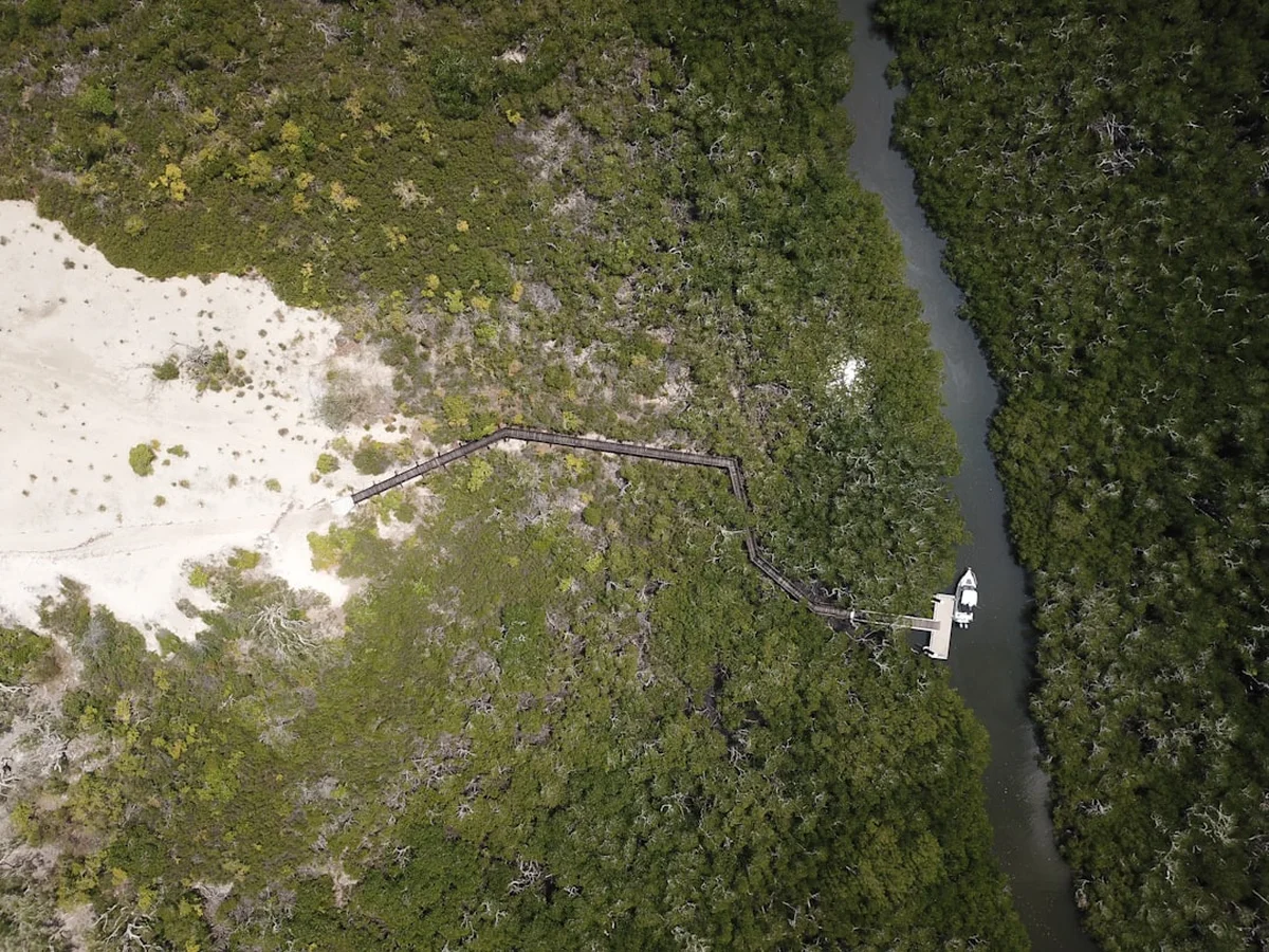
- Ferry transfer from Cardwell to the Ramsay Bay boardwalk
- Walk along the pristine sands of Ramsay Bay, heading south
- Cross the lagoon (check tides) and enter the forest
- Ascend the saddle behind Nina Peak for spectacular views of the coastline
- Optional: Side trip to the summit of Nina Peak (312 m) for a 360-degree panorama
- Descend to Nina Bay, a stunning crescent beach framed by granite boulders
- Camp at Nina Bay (designated site with basic toilet)
- This short first day allows for travel time and an easy introduction to the island's terrain
Day 2: Nina Bay to Zoe Bay
- Distance: 10.5 km
- Elevation gain: 250 m
- Time: 5–6 hours
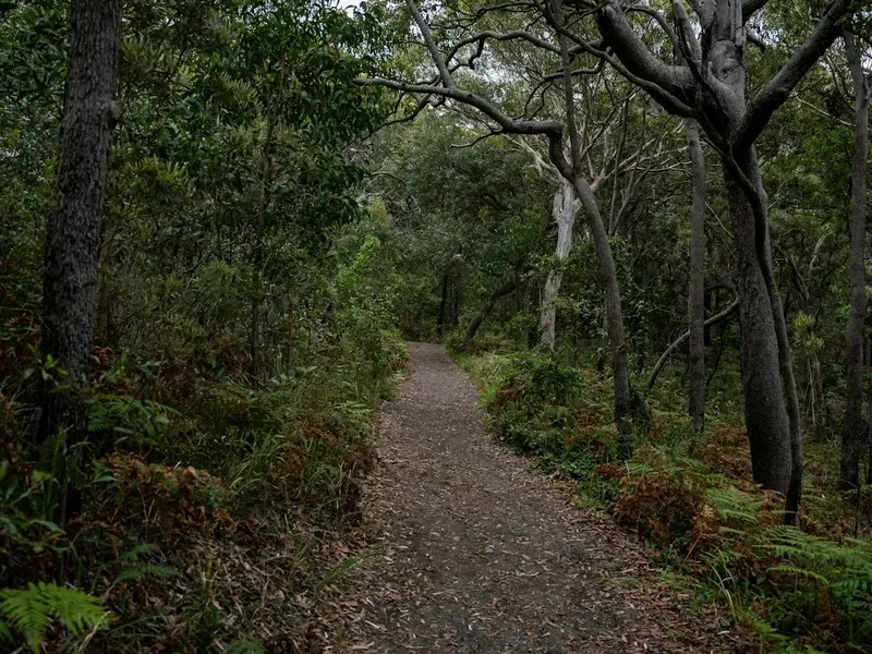
- Depart Nina Bay and head inland through melaleuca swamps and eucalyptus forest
- Navigate the rocky headland at Boulder Bay (tide dependent)
- Cross North Nina Creek and South Nina Creek (freshwater sources)
- Traverse the "Swamp" section—can be muddy and slow-going after rain
- Ascend the ridge before descending into the vast, mangrove-lined Zoe Bay
- Walk the length of Zoe Bay beach to the southern end
- Camp at Zoe Bay, located near the mouth of Zoe Creek
- Zoe Bay is famous for its sunrise views and the nearby Zoe Falls
Day 3: Zoe Bay to Mulligan Falls
- Distance: 7.5 km
- Elevation gain: 300 m
- Time: 4–5 hours
- Begin with a steep climb to the top of Zoe Falls
- Pause at the "infinity pool" at the crest of the falls for a swim and world-class views
- Continue inland, following the creek through dense rainforest
- Cross the high saddle between the Zoe and Mulligan watersheds
- The trail here is rugged, with many roots and rocks to negotiate
- Descend steeply through lush vine forest to the base of Mulligan Falls
- Camp at Mulligan Falls (strictly no camping on the rocks or near the falls themselves)
- Mulligan Falls offers a spectacular swimming hole and a permanent freshwater source
Day 4: Mulligan Falls to George Point
- Distance: 10 km
- Elevation gain: 50 m
- Time: 3–4 hours
- Depart Mulligan Falls and head south towards the coast
- Cross several small creeks and navigate through dense coastal scrub
- Reach the beach and begin the long walk south towards George Point
- This section is entirely beach walking and is highly dependent on the tide
- Pass through the Diamantina Creek area (be vigilant for crocodiles)
- Arrive at George Point, the southern terminus of the trail
- Ferry transfer from George Point back to Lucinda or Cardwell
- Ensure your arrival at George Point aligns with your pre-booked ferry time
Important Notes:
- The trail is rugged and often overgrown; long trousers are recommended to protect against "wait-a-while" vines
- Tidal awareness is crucial for several creek and lagoon crossings
- Water must be treated at all sources
- Campsites must be booked well in advance through the QLD National Parks website
- Always check the latest track conditions and weather alerts before departing
Planning and Bookings
Book Your Trip
Everything you need to plan your journey
Accommodation
Find places to stay near Cardwell
Flights
Search flights to Cardwell
Essential Preparation
The Thorsborne Trail requires meticulous planning, as it is a remote island experience with no "exit" points once you have started. The first step is to coordinate your trail permits with your ferry transfers. Because permits are limited to 40 people, they often sell out months in advance, particularly for the peak winter months. You should secure your permit first, then immediately book your ferry transfers from either Cardwell or Lucinda.
Physical fitness is paramount. While 32 kilometres may sound short, the tropical heat, humidity, and rugged terrain make it feel significantly longer. You will be carrying a full pack with all your food, water, and camping gear. Training with a weighted pack on uneven terrain is highly recommended. Additionally, you must be self-sufficient in first aid and navigation. While the trail is generally marked with orange markers, they can be obscured by rapid vegetation growth or fallen trees.
Cardwell and Lucinda are the two main gateway towns. Cardwell is accessible by bus or train from Cairns or Townsville. Lucinda is a smaller coastal town further south, closer to the southern end of the trail. Most walkers choose to be dropped off at the northern end (Ramsay Bay) and picked up at the southern end (George Point), but the reverse is also possible. Ensure you have a reliable way to contact the ferry operators if your plans change, though mobile signal is extremely limited on the island.
Trail Accommodation
There are no huts or permanent structures on the Thorsborne Trail. Accommodation is strictly limited to seven designated wilderness campsites: Nina Bay, Little Ramsay Bay, Banksia Bay, Zoe Bay, Mulligan Falls, and George Point. There is also a small site at North Ramsay, though it is rarely used by through-hikers.
Campsite Facilities:
- Basic composting or pit toilets are provided at most major sites (Nina Bay, Little Ramsay, Zoe Bay, Mulligan Falls)
- Metal "rat-proof" food storage lockers are available at most sites to protect your supplies from native rodents and goannas
- No tables, benches, or shelters are provided
- No treated water is available; all water must be collected from creeks and treated
- No rubbish bins; you must pack out everything you bring in
Booking Requirements:
- Permits must be booked through the Queensland National Parks (DES) online booking system
- The cost is approximately AU$7.25 per person, per night (subject to change)
- You must specify which campsites you intend to stay at each night
- Maximum stay at any one campsite is two nights
- Group sizes are limited to a maximum of six people
Required Gear
- Sturdy hiking boots - waterproof is less important than drainage and grip on wet granite
- Lightweight tent - must have a high-quality insect mesh to keep out midges and mosquitoes
- Sleeping mat - essential for comfort on uneven ground
- Lightweight sleeping bag or silk liner - temperatures rarely drop below 15°C in winter
- Backpack - 50–65L with a high-quality harness and rain cover
- Navigation - Topographic map and compass (essential), GPS or offline map app (recommended)
- First aid kit - including pressure bandages (for snakes), antiseptic, rehydration salts, and blister care
- Head torch - with spare batteries
- Trowel - for toileting if away from designated facilities
What to Bring
- Food for 4 days - lightweight, high-calorie dehydrated meals are best. Avoid aromatic foods that attract wildlife
- Water treatment - a high-quality filter (like a Sawyer Squeeze) or purification tablets (Micropur) is mandatory
- Water storage - capacity to carry at least 4 litres per person, especially for the Zoe to Mulligan section
- Stove and fuel - lightweight gas or methylated spirits stove (no fires allowed on the island)
- Clothing - moisture-wicking, quick-dry fabrics. Long sleeves and trousers for sun and vine protection
- Sun protection - SPF 50+ sunscreen, wide-brimmed hat, and polarised sunglasses
- Insect repellent - high-strength DEET or Picaridin for mosquitoes and sandflies (midges)
- Dry bags - to keep your clothes and electronics dry during creek crossings and tropical downpours
- Personal Locator Beacon (PLB) - highly recommended as there is no reliable mobile coverage
Permits
Permits for the Thorsborne Trail are managed by the Queensland Department of Environment and Science (DES). Due to the trail's popularity and the strict limit of 40 walkers, securing a permit requires forward planning. Permits become available 12 months in advance on a rolling basis. For the popular winter months (June, July, August), permits often sell out within minutes of being released.
Booking Strategy:
- Create an account on the Queensland National Parks booking website well before you intend to book
- Identify your preferred start date and have several backup dates ready
- Log in exactly at the time permits are released (usually midnight AEST)
- Be prepared to pay immediately via credit card to secure your spot
- If the trail is "sold out," check back frequently for cancellations, which are common 2–4 weeks before the date
Permit Costs:
- Camping permit: Approximately AU$7.25 per person, per night
- Hiking-only permits are not required, but since the trail takes 3–4 days, camping permits are essential
- Ferry transfers are a separate cost, typically ranging from AU$150 to AU$200 per person for a return trip
Important Compliance: You must carry a hard copy or digital version of your permit at all times. Rangers do patrol the island, and fines apply for camping without a permit or staying at a site other than the one specified on your booking. The permit system is the primary tool for managing the environmental impact on this fragile World Heritage area.
Other Activities in the Area
The region surrounding Hinchinbrook Island, known as the Cassowary Coast, offers several other attractions for those looking to extend their stay:
- Cardwell Spa Pools: A natural geological phenomenon where the water turns a vibrant, milky blue due to the chemistry of the rocks and water. Located just a short drive from Cardwell.
- Wallaman Falls: Located in Girringun National Park, this is Australia's highest single-drop waterfall (268 m). It is a spectacular sight and offers several walking tracks.
- Lucinda Jetty: At 5.76 kilometres long, this is one of the longest service jetties in the world, used for loading sugar onto ships. It is a marvel of engineering and a popular spot for photography.
- Snorkelling and Diving: While the waters immediately around Hinchinbrook are often murky due to mangroves, the outer Great Barrier Reef is accessible via charter tours from Mission Beach or Townsville.
- Tyto Wetlands: Located in Ingham, these wetlands are a haven for birdwatchers, with over 240 species of birds recorded, including the rare Eastern Grass Owl.
Safety and Conditions
Estuarine Crocodiles: Hinchinbrook Island is "Croc Country." Estuarine (saltwater) crocodiles are apex predators and inhabit the island's mangroves, estuaries, and occasionally the open beaches. To stay safe: never camp near the water's edge, avoid cleaning fish or disposing of food scraps in the water, and be extremely vigilant during creek crossings, especially at high tide or in murky water. Always assume a crocodile is present even if you cannot see one.
Heat and Hydration: Tropical heat can be lethal. Even in winter, the combination of 26°C temperatures and 80% humidity can lead to rapid dehydration and heat exhaustion. You must drink at least 3–4 litres of water per day. If you stop sweating, feel dizzy, or develop a headache, stop immediately, find shade, and rehydrate with electrolytes.
Creek Crossings: The trail involves numerous creek crossings. During or after heavy rain, these creeks can become impassable. Never attempt to cross a flooded creek; wait for the water level to drop, which usually happens quickly once the rain stops. Be aware of tidal influences on creeks near the coast, as incoming tides can make crossings deeper and bring crocodiles further upstream.
Marine Stingers: From October to May, the waters surrounding the island are home to dangerous jellyfish, including the Box Jellyfish and Irukandji. Swimming in the ocean is not recommended during these months. Even in winter, caution is advised. The freshwater pools at the top of Zoe Falls and Mulligan Falls are generally safe from marine stingers.
Emergency Communication: There is almost no mobile phone reception on the Thorsborne Trail. A Personal Locator Beacon (PLB) is an essential piece of safety equipment. In the event of a life-threatening emergency, a PLB is your only reliable way to summon help. Ensure your PLB is registered and that you know how to deploy it.
Side Trips and Points of Interest
Zoe Falls Infinity Pool: Located just a short, steep climb from the Zoe Bay campsite, the top of Zoe Falls is perhaps the most photographed spot on the island. The natural rock pools offer a safe place to swim with a view that stretches across the rainforest canopy to the turquoise waters of the Coral Sea. It is the perfect place to spend an afternoon resting tired legs.
Nina Peak: For those with extra energy on Day 1, the scramble to the summit of Nina Peak (312 m) is highly rewarding. The track is steep and unformed, requiring some rock scrambling, but the view from the top provides a perfect overview of the island's northern coastline, including Ramsay Bay and the jagged peaks of the interior.
Mulligan Falls: These falls are a powerful display of the island's rugged beauty. The campsite is located just a few hundred metres from the base of the falls. The large, deep pool at the bottom is ideal for swimming, but be careful on the surrounding rocks, which are incredibly slippery when wet. Note that the area immediately around the falls is a restricted access area to protect the fragile vegetation and ensure visitor safety.
Mount Bowen: At 1,121 metres, Mount Bowen is the highest point on the island. Reaching the summit is a serious undertaking that requires a separate permit and advanced navigational skills. There is no formed trail, and the ascent involves thick vegetation and steep rock slabs. It is only recommended for very experienced off-track hikers.
Leave No Trace
Hinchinbrook Island is a fragile ecosystem that relies on the responsible behaviour of every visitor. As a World Heritage-listed area, the standards for environmental protection are high. Following the Leave No Trace principles is not just a recommendation; it is a requirement for preserving this wilderness.
Key Principles for the Thorsborne Trail:
- Pack it in, pack it out: This includes all food scraps, tea bags, and hygiene products. Never bury rubbish, as goannas and rats will quickly dig it up.
- Respect Wildlife: Do not feed any animals. The island's goannas and native rats are highly opportunistic and will raid your pack if food is not secured in the provided lockers.
- Water Protection: When washing yourself or your dishes, ensure you are at least 50 metres away from any water source. Use only biodegradable soaps, or better yet, no soap at all.
- Toileting: Use the provided toilets at the campsites. If you are caught short between sites, bury your waste at least 15–20 cm deep and at least 100 metres away from water and the trail. Pack out your used toilet paper in a sealed bag.
- No Fires: Hinchinbrook Island is a fuel-stove-only area. Campfires are strictly prohibited as they pose a wildfire risk and deplete the forest of essential fallen timber.
- Stay on Track: Avoid creating new paths or shortcuts, which can lead to erosion and the spread of weeds or soil-borne diseases like Phytophthora cinnamomi (root rot).