
The Narrows - Zion’s Masterpiece of Stone and Water
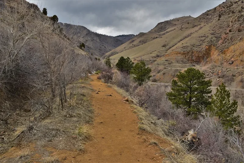
The Narrows is not merely a hike; it is an immersive journey into the geological heart of Zion National Park. Located in the southwestern United States, this legendary route follows the Virgin River as it carves a path through a spectacular gorge where the canyon walls rise over 300 metres vertically, sometimes narrowing to a mere 6 to 10 metres apart. Unlike traditional trails, the river itself serves as the path for over sixty per cent of the journey. Walkers must navigate slippery river stones, varying water depths, and the constant flow of the current, making it one of the most unique and physically demanding day walks in North America. The 25.7-kilometre "Top-Down" route from Chamberlain’s Ranch to the Temple of Sinawava offers a profound sense of isolation and grandeur, transitioning from high-plateau meadows into the deep, shadowed recesses of the North Fork of the Virgin River.
- Distance: 25.7 km (Top-Down route)
- Duration: 8–12 hours (one day) or 2 days (overnight)
- Season: May to October (subject to spring runoff and flash flood risks)
- Elevation Loss: 426 m (descending from the plateau)
- Highest Point: 1,740 m (Chamberlain's Ranch)
- Difficulty: Moderate to Strenuous (due to river walking and distance)
- Direction: Top-Down (one-way) or Bottom-Up (return)
Overview
The Narrows represents the quintessential slot canyon experience. Carved over millions of years by the relentless force of the Virgin River, the canyon is a testament to the power of erosion. The walls, composed of Navajo Sandstone, display a stunning palette of colours—from deep ochre and burnt orange to pale cream and charcoal grey—often changing hue as the sun moves across the narrow sliver of sky visible from the canyon floor. This is a landscape of verticality, where the scale of the cliffs is so immense that it challenges one's sense of perspective. The "Top-Down" journey is the definitive way to experience the canyon's evolution, starting in a wide, shallow valley and gradually descending into the "Wall Street" section, where the cliffs are at their most claustrophobic and awe-inspiring.
Walking The Narrows is a sensory experience unlike any other. The sound of the river is a constant companion, ranging from a gentle babble in the wider sections to a thunderous roar during periods of high flow. The air temperature drops significantly as you enter the deeper reaches of the gorge, where direct sunlight may only reach the canyon floor for an hour or two each day. The water itself is a living element; its temperature, clarity, and depth dictate the pace of the journey. In the height of summer, the cool water provides a welcome respite from the desert heat, but it also requires walkers to be constantly mindful of their footing on the "slippery bowling balls"—the smooth, algae-covered rocks that line the riverbed.
While many visitors experience the first few kilometres of the canyon via the "Bottom-Up" route from the Temple of Sinawava, the full 25.7-kilometre Top-Down trek offers a level of solitude and immersion that is increasingly rare in popular national parks. By starting at Chamberlain’s Ranch, walkers leave the crowds behind and enter a wilderness area where the only signs of civilisation are the occasional footprints in the sand. This route requires careful planning, a permit, and a shuttle service, but the reward is a deep, uninterrupted connection with one of the most spectacular natural wonders on Earth.
History and Cultural Context
The history of The Narrows is inextricably linked to the indigenous peoples who have called this region home for millennia. The Southern Paiute people, who inhabited the Virgin River Valley long before European arrival, referred to the canyon as "Mukuntuweap," which has been interpreted to mean "straight canyon" or "place of the spirit." To the Paiute, the canyon was a place of great spiritual significance and a source of vital resources. While they did not typically live within the deep, flood-prone sections of The Narrows, they utilised the surrounding plateaus and the wider valley floors for hunting and gathering.
European exploration of the area began in the mid-19th century. Mormon pioneers arrived in the 1850s and 1860s, naming the area "Zion," a Hebrew word meaning a place of refuge or sanctuary. In 1872, the geologist and explorer John Wesley Powell led an expedition through the region, providing the first formal scientific descriptions of the canyon's unique geology. Powell was instrumental in naming many of the park's features and bringing national attention to its extraordinary beauty. The area was originally designated as Mukuntuweap National Monument in 1909 by President William Howard Taft, but the name was changed to Zion National Monument in 1918, and it achieved National Park status in 1919.
The development of The Narrows as a recreational route began in the early 20th century as the park's infrastructure improved. However, it remained a formidable challenge for all but the most adventurous explorers until the latter half of the century. Today, the management of The Narrows reflects a delicate balance between preserving its wilderness character and accommodating the thousands of walkers who seek to experience its majesty. The permit system for the Top-Down route was established to protect the fragile riparian environment and ensure that the sense of solitude—so central to the experience—is maintained for future generations.
Want more background? Read extended notes on history and cultural context → Learn more
Seasonal Highlights and Weather Reality
The Narrows is a seasonal trail, and its accessibility is entirely dependent on the behaviour of the Virgin River. The most popular time to walk is from late May to early October, but each month brings its own set of conditions and challenges. Understanding the seasonal cycle is critical for a safe and enjoyable journey.
Spring (March to May): This is the period of spring runoff. As snow melts on the high plateaus to the north, the Virgin River swells, often reaching flow rates that make walking impossible. The park service typically closes The Narrows when the flow rate exceeds 150 cubic feet per second (cfs). In many years, the trail does not open until late May or even June. Even when open, the water is extremely cold (often below 10° Celsius), requiring full dry suits and specialised gear.
Summer (June to August): This is the peak season for The Narrows. The water temperatures rise to a more comfortable 15–20° Celsius, and the air temperatures in Zion Canyon can soar above 35° Celsius. However, summer also brings the "Monsoon Season" (typically July through September). During this time, afternoon thunderstorms can trigger sudden and catastrophic flash floods. A storm many kilometres away can send a wall of water, mud, and debris down the canyon with no warning. Walkers must check the flash flood potential daily and be prepared to cancel their trip if the risk is high.
Autumn (September to October): Many experienced walkers consider this the best time to visit. The flash flood risk begins to diminish, the crowds thin out, and the cottonwood trees along the river turn a brilliant gold. The water remains relatively warm through September, though by October, the air temperatures begin to drop, and the days become shorter. Early autumn offers the most stable weather and the most beautiful light for photography.
Winter (November to February): Walking The Narrows in winter is a serious undertaking. The water is near freezing, and the canyon floor receives almost no sunlight. Full dry suits, neoprene socks, and thermal layers are mandatory. While the canyon is hauntingly beautiful in the snow, the risk of hypothermia is extreme, and the logistics are complicated by shorter days and potential ice on the trailheads.
Recommended Itinerary
The Top-Down One-Day Journey (25.7 km)
Early Morning: The High Plateau Start
- 06:00 – 07:00: Depart Springdale via private shuttle to Chamberlain’s Ranch (approx. 1.5-hour drive).
- 07:30: Begin the walk at Chamberlain’s Ranch (Elevation: 1,740 m).
- The first 5 kilometres follow a private dirt road through open ranch land and meadows.
- The trail is flat and easy, allowing for a brisk pace to warm up the legs.
- Cross the first few shallow fords of the North Fork of the Virgin River.
Mid-Morning: Entering the Upper Canyon
- 09:30: Reach the boundary of Zion National Park.
- The canyon walls begin to rise, and the valley narrows significantly.
- The "trail" now stays primarily in the riverbed.
- Pass the confluence with Simon’s Gulch.
- The scenery transitions from scrub oak and ponderosa pine to the first sheer sandstone cliffs.
- Terrain: Mixed sand, gravel, and small river stones.
Midday: The Deepening Gorge
- 12:00: Reach the "Deep Creek" confluence.
- The water volume increases significantly as Deep Creek joins the North Fork.
- The canyon becomes more dramatic, with walls reaching 100–200 metres in height.
- Pass the designated overnight campsites (Campsites 1 through 12).
- Stop for a quick lunch on a high sandbank; avoid lingering in narrow sections.
- Water depth: Typically ankle to knee-deep, with occasional waist-deep pools.
Afternoon: Wall Street and the Narrows
- 14:00: Enter the "Wall Street" section—the narrowest and most famous part of the canyon.
- The walls rise 300 metres vertically, and the sky is reduced to a thin ribbon of blue.
- Pass the confluence with Orderville Canyon (a spectacular side canyon).
- Navigate the "slippery bowling balls"—large, smooth rocks that require careful foot placement.
- Pass Big Spring, where water gushes directly from the canyon wall, creating a lush hanging garden.
- This section is the most physically demanding but also the most visually stunning.
Late Afternoon: The Final Stretch
- 16:30: Reach the "Gateway to the Narrows."
- The canyon begins to widen slightly as you approach the end of the river section.
- Encounter the "Bottom-Up" day hikers coming from the Temple of Sinawava.
- 17:30: Exit the river at the Riverside Walk trailhead.
- Walk the final 1.6 kilometres on a paved path to the Temple of Sinawava shuttle stop.
- 18:00: Board the Zion Canyon Shuttle for the return trip to the Visitor Centre and Springdale.
Important Notes:
- This itinerary is for fit, experienced walkers. If you prefer a slower pace, consider the 2-day overnight option.
- Shuttle times are critical; ensure you know the time of the last departing shuttle from the Temple of Sinawava.
- Pace will vary wildly depending on water levels and flow rates.
- Always keep an eye on the sky and be aware of the nearest high ground in case of flash floods.
Planning and Bookings
Book Your Trip
Everything you need to plan your journey
Accommodation
Find places to stay near Springdale, Utah
Flights
Search flights to Springdale, Utah
Essential Preparation
The Narrows Top-Down hike requires more logistical coordination than almost any other trail in Zion. Because it is a point-to-point route, you must arrange transport to the remote Chamberlain’s Ranch trailhead, which is located on private property outside the park boundaries. Most walkers use one of the several private shuttle services based in Springdale. These shuttles typically depart early in the morning and must be booked weeks in advance during the peak season.
Physical fitness is a major factor. Walking 25 kilometres is challenging on flat ground; doing so while balancing on uneven, submerged rocks against a current is significantly more taxing. You will use muscles in your ankles, knees, and core that are rarely engaged on standard trails. It is highly recommended to spend at least one day doing a shorter hike in Zion (such as Angels Landing or the Riverside Walk) to acclimatise to the heat and terrain before attempting the full Narrows journey. Springdale serves as the perfect base, offering a wide range of accommodation, gear rental shops, and restaurants.
Trail Accommodation
For the majority of walkers, The Narrows is completed as a strenuous single-day hike. However, for those who wish to savour the experience, there are 12 designated campsites located in the middle section of the canyon (between Deep Creek and Big Spring).
Campsite Details:
- Booking: A specific "Overnight" permit is required. These are highly coveted and must be reserved through the Zion National Park wilderness reservation system.
- Facilities: There are NO facilities at the campsites. No toilets, no tables, and no treated water.
- Waste Management: You are required to carry out all human waste. The park service provides "WAG bags" (Waste Aggregation and Gelling) with your permit.
- Water: You must filter or treat river water. Note that the Virgin River can be silty; a pre-filter or settling bucket is often necessary to avoid clogging filters.
- Group Size: Limited to 12 people per campsite.
- Cost: Permit fees range from US$15 to US$25 depending on group size.
If you are not camping, there is no other accommodation within the canyon. All "Top-Down" day hikers must exit the canyon by nightfall.
Required Gear
- Canyoneering Shoes: Do not wear standard hiking boots. Specialised canyoneering shoes with high-friction rubber (like Stealth rubber) are essential for grip on wet, slimy rocks.
- Neoprene Socks: Even in summer, your feet will be submerged for hours. 3mm neoprene socks prevent blisters and keep your feet warm.
- Walking Pole: A sturdy wooden staff or a dedicated trekking pole is non-negotiable. It acts as a "third leg" for stability in the current.
- Dry Bag: Everything in your pack must be inside a high-quality dry bag. If you slip in a deep pool, your gear (especially electronics and warm layers) must stay dry.
- Waterproof Map: GPS can be unreliable in the deep canyon; a physical, waterproof map is essential for identifying confluences and landmarks.
- Head Torch: Essential for the early start and as a safety measure if you are delayed and must finish in the dark.
- Whistle: For emergency communication in the noisy canyon environment.
What to Bring
- Water: Carry at least 3–4 litres of water. While the river is always there, it requires treatment and can be contaminated with cyanobacteria (blue-green algae).
- Food: High-calorie, easy-to-eat snacks and a substantial lunch. You will burn significantly more calories than on a standard hike.
- Electrolytes: Salt tablets or electrolyte powders to prevent cramping in the heat.
- Sun Protection: While much of the canyon is shaded, the first 5 kilometres and the midday sun in wider sections are intense. Bring a hat and waterproof sunscreen.
- Warm Layer: A lightweight fleece or synthetic jacket. The temperature in the deep narrows can be 10–15 degrees cooler than the rim.
- First Aid Kit: Include plenty of waterproof plasters, moleskin for blisters, and antiseptic wipes.
- WAG Bag: Even for day hikers, carrying a waste bag is a requirement of the permit and a responsible LNT practice.
- Emergency Bivvy: A lightweight emergency blanket in case of an unexpected overnight stay due to injury or weather.
Permits
A wilderness permit is mandatory for all "Top-Down" trips, whether completed in one day or two. The permit system is strictly enforced to manage the number of people in the wilderness section of the canyon and to ensure all walkers are briefed on flash flood safety. There are two ways to obtain a permit:
1. Advance Reservations:
- Reservations become available on the 5th day of every month for the following month (e.g., June reservations open on May 5th).
- These sell out within seconds of becoming available at 10:00 AM Mountain Time.
- You must create an account on the Recreation.gov website in advance.
2. Last-Minute Drawing:
- If advance reservations are full, you can enter a "Last-Minute Drawing" 7 to 2 days before your intended hike date.
- This is a randomised lottery system. You will be notified via email if you are successful.
- Any remaining permits after the drawing are available as "Walk-In" permits at the Zion Canyon Visitor Centre Wilderness Desk the day before your hike.
Permit Costs:
- US$15.00 for 1–2 people.
- US$20.00 for 3–7 people.
- US$25.00 for 8–12 people.
- Note: There is also a non-refundable US$5.00 application fee for the lottery.
Important: You must pick up your physical permit at the Zion Wilderness Desk either the day before or the morning of your hike. You will be required to watch a short safety video and sign a statement acknowledging the flash flood risk. If the river flow is above 150 cfs, all permits are cancelled and no new permits are issued.
Other Activities in the Area
Zion National Park offers a wealth of other world-class experiences that can be combined with a trip to The Narrows:
- Angels Landing: Perhaps the most famous hike in the park, this thrilling ascent involves narrow ridges and chain-assisted climbing to reach a spectacular viewpoint over Zion Canyon. (Permit required).
- Observation Point: For those who want a higher perspective than Angels Landing without the dizzying drops, the trail to Observation Point offers the most comprehensive view of the entire canyon system.
- Canyon Overlook Trail: A short, 1.6-kilometre return walk near the east entrance that provides a stunning view of the lower Zion Canyon with minimal effort.
- Pa’rus Trail: A paved, multi-use path that follows the Virgin River in the lower canyon, perfect for a sunset stroll or a relaxed bicycle ride.
- Canyoneering: Zion is the canyoneering capital of the US. Consider a guided trip into technical slot canyons like The Subway or Mystery Canyon (permits and technical skills required).
- Stargazing: Zion is a certified International Dark Sky Park. The lack of light pollution makes for incredible night skies; consider joining a ranger-led astronomy programme.
Safety and Conditions
Flash Floods: This is the single greatest danger in The Narrows. A flash flood is a sudden rise in water level, often accompanied by a wall of debris. They can occur even when the sky above you is clear. If you see the water becoming muddy, hear a distant roar like a jet engine, or see an increase in floating debris, move to the highest ground possible immediately. Do not try to outrun a flood by moving downstream. There are sections of The Narrows where there is no high ground for several hundred metres; these are "dead zones" during a flood.
Hypothermia: Even in summer, the combination of cold water, shade, and wind can lead to hypothermia. Symptoms include uncontrollable shivering, confusion, and loss of dexterity. Dress in layers, avoid cotton (which loses all insulating properties when wet), and keep moving to generate body heat. If you or a member of your group starts shivering, stop, dry off, and put on warm, dry layers immediately.
Cyanobacteria (Toxic Algae): In recent years, the Virgin River has been affected by toxic cyanobacteria. These toxins can be absorbed through the skin or ingested. Do not submerge your head in the water, and do not drink the river water even if filtered (most portable filters do not remove the toxins). Check the current health advisories at the Visitor Centre before starting your hike.
Foot and Leg Injuries: The riverbed is a minefield of unstable rocks. Twisted ankles and broken toes are the most common injuries. Use a walking staff, take short steps, and never jump from rock to rock. Ensure your footwear is specifically designed for wet, rocky terrain.
Emergency Communication: There is NO mobile phone signal in The Narrows. Satellite messengers (like Garmin inReach) may work in wider sections but are often blocked by the deep canyon walls. You must be self-sufficient. In the event of a serious injury, one person should stay with the victim while others move downstream to seek help from rangers or other hikers.
Side Trips and Points of Interest
Orderville Canyon: Located approximately 4 kilometres upstream from the Temple of Sinawava, this is the most significant side canyon in The Narrows. The first few hundred metres are accessible to Narrows hikers and feature incredibly tight, dark walls and beautiful sculpted sandstone. Note that venturing further up Orderville requires a separate permit and involves technical obstacles.
Big Spring: This is the turnaround point for most "Bottom-Up" hikers and a major landmark for "Top-Down" walkers. Crystal-clear water bursts from the canyon wall, creating a vibrant oasis of moss, ferns, and wildflowers. It is a beautiful spot for a break, but please stay on the rocks to avoid trampling the fragile hanging gardens.
The Veiled Falls: A small but elegant waterfall located in the upper sections of the canyon. It is a perfect example of the "weeping walls" common in Zion, where water percolates through the porous sandstone until it hits an impermeable layer and emerges as a spring.
Wall Street: While not a side trip, this 3-kilometre stretch is the climax of the hike. The walls are at their highest and closest, and the river fills the entire canyon floor. The "North Wall" here is particularly famous for its deep red staining and vertical fluting.
Mystery Canyon Falls: Near the end of the hike, you will pass the exit of Mystery Canyon. A small waterfall often trickles down the wall here. If you are lucky, you might see technical canyoneers rappelling down the final 40-metre drop into The Narrows.
Leave No Trace
The Narrows is a fragile riparian ecosystem that sees hundreds of thousands of visitors each year. To preserve this environment, all walkers must adhere to strict Leave No Trace principles. The "pack it in, pack it out" rule applies to everything, including organic waste like orange peels and apple cores, which do not decompose quickly in the arid canyon environment.
Specific Narrows Guidelines:
- Human Waste: This is a critical issue. Because there is no soil for "cat holes" and the water is a primary resource, you MUST use WAG bags for all solid human waste. These are available at gear shops in Springdale and the Wilderness Desk.
- Urination: The park service recommends urinating directly into the flowing river (the "dilution is the solution" method) rather than on the sandbanks, where it can create odours and attract pests.
- Riparian Vegetation: Stay in the river or on established sand trails. Avoid walking on the fragile mosses and ferns that grow near springs.
- Group Size: Keep your group small (maximum 12) to minimise your physical and social impact on the wilderness.
- Sound: The canyon walls act as an amphitheatre. Avoid shouting or playing music; let the sound of the river be the dominant soundtrack for everyone.