The Long Trail - A Journey Through the Green Mountain Kingdom
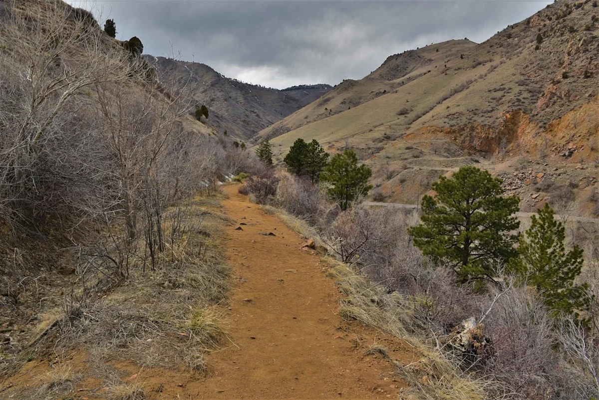
The Long Trail is the oldest long-distance hiking trail in the United States, a rugged and soul-stirring 705.0 km journey that traverses the entire length of Vermont. From the Massachusetts border to the Canadian frontier, this "footpath in the wilderness" follows the main ridge of the Green Mountains, offering a quintessential New England experience defined by dense hardwood forests, moss-covered boulders, and windswept alpine summits. With a staggering 21,000 metres of elevation gain, the trail is a formidable test of endurance, famously known for its "Green Mountain Tunnel"—stretches of deep, emerald canopy that open suddenly onto breathtaking vistas of Lake Champlain and the Adirondacks to the west, and the White Mountains to the east. This is not merely a hike; it is a pilgrimage through the history of American conservation, a path carved by hand and maintained with devotion for over a century.
- Distance: 705.0 km (including primary route and major side trails)
- Duration: 20–30 days
- Season: Mid-June to mid-October (avoiding the notorious "Mud Season")
- Accommodation: Over 70 shelters and campsites maintained by the Green Mountain Club
- Highest point: Mount Mansfield (1,340 m)
- Difficulty: Challenging (rugged terrain, frequent mud, and significant vertical gain)
- Direction: Typically hiked South to North (NOBO), though Southbound (SOBO) is common
Overview
The Long Trail (LT) is the progenitor of the American thru-hiking tradition, serving as the direct inspiration for the Appalachian Trail. However, the LT maintains a distinct character that sets it apart from its more famous younger sibling. While the southern 160 kilometres coincide with the Appalachian Trail, the remaining 545 kilometres heading north toward Canada offer a more secluded, rugged, and technically demanding experience. The terrain is characterised by steep, rocky ascents and descents that often eschew switchbacks in favour of direct, vertical lines—a style of trail building that reflects the hardy spirit of its Vermont creators.
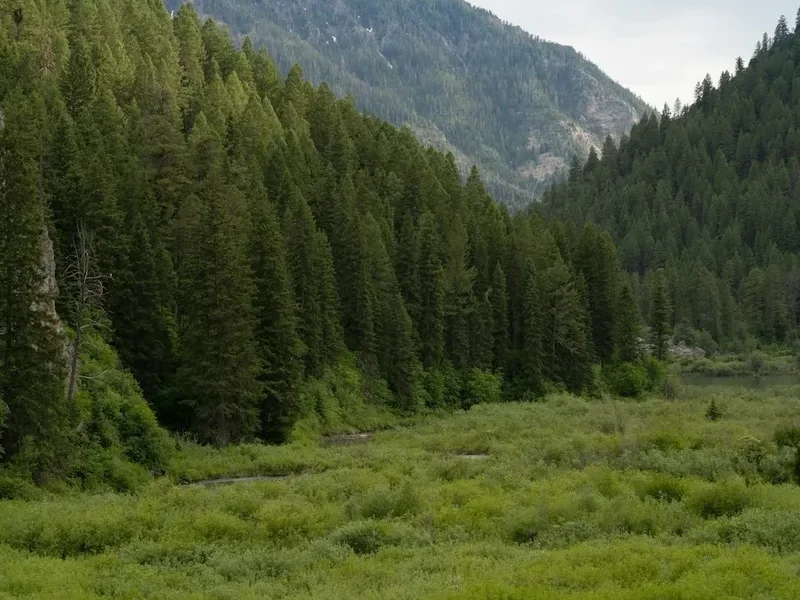
Geologically, the Green Mountains are among the oldest in the world, their jagged peaks worn down by eons of glacial activity and erosion into the rounded, verdant ridges seen today. The trail passes through several distinct life zones, from the northern hardwood forests of maple, birch, and beech at lower elevations to the sub-alpine balsam fir and red spruce forests higher up. On the highest summits, such as Mount Mansfield and Camel's Hump, hikers encounter rare alpine tundra—fragile remnants of the last ice age that exist nowhere else in the state. This ecological diversity ensures that every day on the trail presents a new landscape, from the boggy lowlands of the Lye Brook Wilderness to the exposed, rocky "Monroe Skyline."
The experience of hiking the Long Trail is often defined by the elements. Vermont's weather is famously unpredictable; a clear morning can transform into a torrential downpour by midday, turning the trail into what locals affectionately (or frustratedly) call "the long puddle." This moisture is what gives the Green Mountains their name and their vibrant, mossy aesthetic, but it also demands a high level of physical and mental resilience from the hiker. Navigating the "Green Mountain Tunnel" requires a meditative focus, where the reward is not always a grand vista, but the quiet beauty of a fern-filled glade or the haunting call of a hermit thrush at twilight. For those who complete the journey, the Long Trail offers a profound sense of accomplishment and a deep connection to the wild heart of New England.
History and Cultural Context
The Long Trail was born from the vision of James P. Taylor, an educator who, in 1909, sat on the slopes of Stratton Mountain and imagined a continuous footpath connecting Vermont's highest peaks. At the time, the concept of a long-distance hiking trail was revolutionary. In 1910, Taylor and a group of like-minded enthusiasts formed the Green Mountain Club (GMC) with the express purpose of making the Vermont mountains accessible to those who "love the outdoors." The first sections of the trail were blazed shortly thereafter, and by 1930, the path reached the Canadian border, becoming the first long-distance trail of its kind in the United States.
The cultural legacy of the trail is inextricably linked to the GMC, which remains the trail's primary steward. For over 110 years, the club has relied on a dedicated network of volunteers and professional trail crews to maintain the path, build shelters, and protect the surrounding corridor. This "volunteer spirit" is palpable along the route, from the hand-carved signs to the meticulously maintained stone water bars. The trail also holds a special place in the history of the Appalachian Trail (AT); it was while working on the Long Trail that Benton MacKaye conceived the idea for a trail spanning the entire Appalachian range, using the LT as his blueprint.
Beyond its recreational history, the land the trail traverses is the ancestral home of the Abenaki people, who have lived in the N'dakinna (homeland) for thousands of years. Many of the mountain names and geographical features carry indigenous significance, and the trail serves as a reminder of the enduring relationship between the people and the land. Today, the Long Trail is more than just a recreational asset; it is a symbol of Vermont's commitment to conservation and a living museum of the American hiking movement.
Want more background? Read extended notes on history and cultural context → Learn more
Seasonal Highlights and Weather Reality
Timing is everything when planning a Long Trail thru-hike. The window for a successful journey is relatively narrow, dictated by the harsh Vermont winters and the equally challenging "Mud Season."
Summer (Late June to August): This is the most popular time for thru-hiking. The days are long, the forest is at its most lush, and the weather is generally warm. However, hikers must contend with "black fly season" in June and early July, where biting insects can be relentless. Humidity is also a factor, and afternoon thunderstorms are common. This is the best time for those who enjoy the social aspect of the trail, as shelters are often full of fellow hikers.
Autumn (September to mid-October): Many experienced hikers consider this the "golden window." The biting insects have vanished, the air is crisp and dry, and the humidity drops significantly. Most importantly, the "fall foliage" transforms the Green Mountains into a spectacular tapestry of reds, oranges, and yellows. The visual reward is unparalleled, though hikers must be prepared for freezing temperatures at night and shorter daylight hours. By mid-October, the risk of early snow on the high peaks increases.
The "Mud Season" Warning (April to mid-June): The Green Mountain Club and the Vermont Department of Forests, Parks and Recreation officially request that hikers stay off high-elevation trails during this period. As the snow melts, the thin alpine soils become saturated and extremely fragile. Hiking during this time causes significant erosion and destroys the trail's infrastructure. Many sections of the trail are officially closed until the ground dries out, typically around Father's Day (mid-June).
Winter (November to March): The Long Trail becomes a serious mountaineering and backcountry skiing proposition in winter. Deep snow, sub-zero temperatures, and extreme wind chill on the ridges make it unsuitable for standard thru-hiking. Only those with advanced winter survival skills and specialised equipment should attempt sections of the trail during these months.
Recommended Itinerary

25-Day Long Trail Thru-Hike Itinerary
Day 1–5: The Southern Wilderness (Massachusetts Border to Stratton Mountain)
- Distance: 85 km
- Elevation: Significant steady climbs through hardwood forests
- Key Waypoints: Pine Cobble Trail, Seth Warner Shelter, Glastenbury Mountain, Stratton Mountain
- The journey begins at the Vermont/Massachusetts border. The first few days involve climbing onto the main ridge.
- Glastenbury Mountain offers a remote fire tower with 360-degree views of the southern wilderness.
- Stratton Mountain is the birthplace of the trail's concept; the fire tower here provides views of the peaks to the north.
Day 6–10: The AT Overlap and the Big Peaks (Stratton to Sherburne Pass)
- Distance: 110 km
- Elevation: High peaks and steep descents
- Key Waypoints: Bromley Mountain, Peru Peak, Little Rock Pond, Killington Peak
- The trail shares its path with the Appalachian Trail here, meaning more social interaction and well-worn paths.
- Bromley Mountain offers a unique experience of walking across a ski resort summit.
- Killington Peak (1,291 m) is a major milestone; the climb is strenuous but the views of the White Mountains are exceptional.
Day 11–15: The Gap Country (Sherburne Pass to Appalachian Gap)
- Distance: 125 km
- Elevation: Constant "Pups"—small but steep peaks
- Key Waypoints: Horrid Cliffs, Middlebury Gap, Breadloaf Wilderness, Lincoln Gap
- North of Sherburne Pass, the AT veers east toward New Hampshire, and the Long Trail becomes quieter and more rugged.
- The Breadloaf Wilderness offers some of the most pristine forest on the entire route.
- The "Monroe Skyline" begins near the end of this section, featuring some of the most technical ridge walking in Vermont.
Day 16–20: The High Peaks and the Monroe Skyline (Appalachian Gap to Johnson)
- Distance: 135 km
- Elevation: The most challenging vertical gain of the trip
- Key Waypoints: Camel's Hump, Mount Mansfield, Smugglers' Notch, Whiteface Mountain
- Camel's Hump is an iconic, un-developed summit with 360-degree views and fragile alpine tundra.
- Mount Mansfield (1,340 m) is the highest point in Vermont; the trail traverses the "Chin" and the "Forehead" via rocky scrambles.
- Smugglers' Notch is a dramatic, boulder-filled pass with towering cliffs on either side.
Day 21–25: The Wild North (Johnson to Canadian Border)
- Distance: 120 km (including side trails to Journey's End)
- Elevation: Remote, rugged, and often muddy
- Key Waypoints: Devil's Gulch, Belvidere Mountain, Jay Peak, Journey's End
- The northernmost section is the most remote. Resupply options are fewer, and the trail feels truly wild.
- Jay Peak offers a final high-alpine experience before the trail descends toward the border.
- The journey concludes at the "Journey's End" monument at the Canadian border, followed by a short hike out to the trailhead.
Important Notes:
- Distances are approximate and include common side trails to water sources and shelters.
- Pacing should be adjusted based on weather and physical condition; 20-30 km per day is standard for experienced thru-hikers.
- Water sources can be seasonal; always check the latest GMC trail reports.
- The northern section (North of Route 15) is significantly more rugged than the southern section.
Planning and Bookings
Book Your Trip
Everything you need to plan your journey
Accommodation
Find places to stay near Burlington
Flights
Search flights to Burlington
Essential Preparation
Preparation for the Long Trail requires a focus on physical conditioning and logistical coordination. Unlike many Western US trails, the LT is characterised by "relentless" terrain—short, steep climbs and descents that test the knees and cardiovascular system. Training should include hiking with a weighted pack on uneven terrain. Logistically, Burlington serves as the primary hub for international and domestic travellers. From Burlington International Airport (BTV), hikers can take shuttles or buses to the southern terminus near Williamstown, Massachusetts, or the northern terminus near North Troy.
The Green Mountain Club's "End-to-Ender's Guide" is the essential planning resource, providing detailed information on resupply points, post offices, and hiker-friendly hostels. It is also highly recommended to join the GMC; membership supports trail maintenance and provides discounts on guidebooks and maps. Coordination of resupply is critical, as some sections in the north have limited access to towns.
Trail Accommodation
The Long Trail features an extensive network of over 70 managed sites, including three-sided lean-tos (shelters), enclosed lodges, and designated tent sites. These are spaced roughly 8 to 15 kilometres apart, allowing for flexible daily distances.
Hut and Shelter Facilities:
- Lean-tos: Three-sided wooden structures with a raised floor. No bedding or mattresses provided.
- Lodges: Enclosed structures, some with wood stoves (though wood is rarely provided).
- Tent Platforms/Sites: Available at most shelter locations to minimise impact on the forest floor.
- Water: Most sites are located near a spring or stream (treatment mandatory).
- Privies: Composting or pit toilets are provided at almost all designated sites.
- Caretakers: During the summer, some high-use sites (like Stratton Pond or Mount Mansfield) have GMC caretakers who collect a small fee (approx. US$5-10) to help maintain the facilities.
What is NOT Provided:
- Bedding, pillows, or blankets.
- Cooking equipment or fuel.
- Food or rubbish removal (Pack it in, pack it out).
- Electricity or mobile charging.
Booking Requirements: No advance bookings are required for shelters or campsites; they operate on a first-come, first-served basis. During peak summer months, shelters can be crowded, so always carry a lightweight tent or tarp as a backup. Camping is generally permitted on state forest land, provided it is 60 metres from the trail and water sources, but using designated sites is strongly encouraged to protect the environment.
Required Gear
- Hiking Boots: Sturdy, waterproof boots with excellent grip are essential for the wet, rocky terrain. Many thru-hikers prefer trail runners, but they must be prepared for constant wet feet.
- Rain Gear: A high-quality waterproof jacket and overtrousers are non-negotiable. Vermont's weather changes rapidly.
- Backpack: 50–65L capacity with a waterproof liner or cover.
- Sleeping System: A 3-season sleeping bag (rated to -5°C for autumn) and a sleeping pad for insulation from the cold ground or wooden shelter floors.
- Navigation: The GMC Long Trail Map and a compass. While GPS apps are useful, battery life is a concern in the dense forest.
- Bear Protection: A bear canister or a robust bear-bagging kit (rope and waterproof bag) is required. Black bears are active throughout the Green Mountains.
- First Aid: Including blister care (moleskin/leukotape), antiseptic, and any personal medications.
- Headlamp: With spare batteries, essential for shelter life and emergency navigation.
What to Bring
- Food: High-calorie, lightweight meals for 4–7 day stretches between resupply points.
- Water Treatment: A reliable filter (like a Sawyer Squeeze) or chemical purification tablets. Giardia is a risk in all Vermont water sources.
- Cooking System: A lightweight stove (canister or alcohol) and fuel.
- Clothing Layers: Moisture-wicking base layers (merino wool is ideal), an insulating mid-layer (fleece or down), and extra socks (at least 3 pairs).
- Sun and Bug Protection: Sunscreen, sunglasses, and high-strength insect repellent (DEET or Picaridin). A head net is highly recommended for June/July.
- Toiletries: Biodegradable soap, trowel (if not using privies), and hand sanitiser.
- Emergency Kit: A whistle, fire starter, and a lightweight emergency bivy or space blanket.
- Power Bank: To keep mobile devices charged for emergency use and photography.
Permits
One of the most appealing aspects of the Long Trail is its accessibility. There is no formal permit system or lottery required to hike the trail, regardless of whether you are doing a day hike or a full thru-hike. This lack of bureaucracy reflects the Green Mountain Club's mission to keep the mountains open to all.
Registration and Fees:
- Voluntary Registration: Thru-hikers are strongly encouraged to register their hike with the Green Mountain Club online before starting. This helps the GMC track trail usage and provides a record in case of emergencies.
- Shelter Fees: While most shelters are free, a small number of high-use sites staffed by caretakers (such as those in the Mount Mansfield and Camel's Hump areas) charge a nominal fee of approximately US$5–10 per night. This money goes directly toward trail and privy maintenance.
- Group Permits: Organised groups (scouts, schools, etc.) of 10 or more people are required to contact the GMC in advance to coordinate their itinerary and ensure they do not overwhelm specific shelters.
Parking and Access: Most trailheads are located on state or federal land and do not require parking permits. However, some popular access points (like Smugglers' Notch) can have limited parking, and hikers should ensure they are parked legally to avoid towing. There are no fees to enter the Green Mountain National Forest.
Other Activities in the Area
Vermont offers a wealth of experiences for those looking to extend their stay or for support crews following the trail:
- Burlington and Lake Champlain: Explore Vermont's largest city, enjoy the waterfront bike path, or take a scenic ferry across the lake to the Adirondacks.
- Craft Brewery Tours: Vermont has the highest number of breweries per capita in the US. Visit world-famous spots like The Alchemist in Stowe or Hill Farmstead in Greensboro.
- Ben & Jerry’s Factory: Located in Waterbury, near the trail's midpoint, this is a classic Vermont pilgrimage for ice cream lovers.
- Shelburne Museum: A world-class museum of art and Americana set on 45 acres of beautiful gardens and historic buildings.
- Mountain Biking: The Kingdom Trails in East Burke offer some of the best mountain biking in North America, while the Slate Valley Trails provide excellent riding in the south.
- Fly Fishing: Vermont's rivers, such as the Battenkill and the Winooski, are renowned for trout fishing.
Safety and Conditions
Weather and Hypothermia: The most significant safety risk on the Long Trail is the weather. Even in mid-summer, temperatures on the summits can drop toward freezing, and high winds can lead to rapid heat loss. Hypothermia is a genuine threat if a hiker becomes wet and exposed. Always carry a waterproof layer and an insulating layer, even on warm days. If a storm approaches while you are on an exposed ridge (like Mount Mansfield or Camel's Hump), descend to lower elevation immediately.
Terrain Hazards: The LT is famously rocky and root-filled. Ankle sprains and falls are the most common injuries. In the northern sections, the trail involves "scrambling"—using hands and feet to navigate steep rock faces. These sections become extremely slippery when wet. Take your time, use trekking poles, and ensure your footwear has adequate traction.
Wildlife:
- Black Bears: While generally shy, bears can become "problem bears" if they associate hikers with food. Proper food storage (bear canisters or hanging) is mandatory. Never keep food, rubbish, or scented items (toothpaste, etc.) in your tent or shelter.
- Ticks: Black-legged ticks (deer ticks) are prevalent in Vermont and can carry Lyme disease. Wear long trousers in tall grass, use Permethrin on your gear, and perform daily tick checks.
- Moose: While rare, moose can be encountered, especially in the northern wetlands. Give them plenty of space; they can be aggressive if they feel cornered.
Water Safety: Never drink untreated water from streams or ponds. Agricultural runoff and wildlife can contaminate even the most pristine-looking sources with Giardia or Cryptosporidium. Use a reliable filter or purification method for every litre of water consumed.
Emergency Communication: Mobile phone signal is extremely spotty along the trail, especially in the deep valleys and northern sections. Do not rely on your phone for emergency calls. Carrying a satellite messenger (like a Garmin inReach or SPOT) is highly recommended for thru-hikers.
Side Trips and Points of Interest
Mount Mansfield Chin: The highest point in Vermont (1,340 m). While the Long Trail passes over it, taking the time to explore the various side trails on the summit ridge allows you to see the unique alpine tundra and the dramatic "Lakeview" vistas. The "Cliff Trail" offers a more technical alternative for those seeking a challenge.
Camel's Hump: Perhaps the most recognisable peak in Vermont due to its distinctive hump-like profile. It is one of the few high peaks without any development (no ski lifts or roads), offering a pure wilderness experience. The 360-degree view from the summit is arguably the best on the entire trail.
Clarendon Gorge: A dramatic suspension bridge carries the trail over the Mill River. Below, the river has carved a deep, narrow gorge into the rock, creating a popular (though cold) swimming hole for hikers on hot summer days.
Little Rock Pond: A beautiful alpine pond in the southern section, surrounded by large boulders and hemlock trees. It is a perfect spot for a mid-day swim or an overnight stay at the nearby shelter. The reflections of the surrounding peaks in the still water are a photographer's dream.
Devil's Gulch: Located in the northern section near Belvidere Mountain, this is a dramatic, fern-filled chasm filled with massive mossy boulders. The trail weaves through the rocks in a landscape that feels prehistoric and hidden from the world.
Leave No Trace
The Long Trail passes through some of the most ecologically sensitive areas in New England. With thousands of hikers traversing the route each year, adhering to Leave No Trace (LNT) principles is essential to preserving the trail's wilderness character.
Key LNT Practices for the Long Trail:
- Plan Ahead and Prepare: Know the regulations for the area you are hiking in, especially regarding camping and fires.
- Travel and Camp on Durable Surfaces: Stay on the marked trail, even when it is muddy. Walking around mud puddles widens the trail and destroys vegetation. Use designated campsites and shelters whenever possible.
- Dispose of Waste Properly: Pack out all rubbish, including food scraps and hygiene products. Use the provided privies for human waste. If no privy is available, dig a "cathole" 15–20 cm deep at least 60 metres from water and the trail.
- Leave What You Find: Do not pick wildflowers or remove rocks or artefacts. In alpine zones, "carry a rock" programs sometimes exist to help stabilise the trail—follow local signage.
- Minimise Campfire Impacts: Use a lightweight stove for cooking. Fires are discouraged and often prohibited at high-elevation sites. If you must have a fire, use established fire rings and keep it small.
- Respect Wildlife: Observe from a distance and never feed animals. Proper food storage is a critical part of respecting wildlife.
- Be Considerate of Other Visitors: Keep noise levels down in shelters and yield to uphill hikers.