USA — New York City
The Long Path is a demanding 566.4 km route through New York State, connecting urban beginnings in Manhattan to the limestone cliffs of Thacher State Park. This 4-6 week traverse offers a unique transition from civilisation to wilderness, featuring varied terrain from forest to rugged ridges, and challenging ascents.
Distance: 566.4 km
Elevation Gain: 26212 m
Difficulty: Challenging
Duration: 4-6 weeks
The Long Path is a monumental 566.4-kilometre journey that serves as the backbone of New York State’s hiking culture. Stretching from the bustling urban landscape of New York City to the limestone cliffs of John Boyd Thacher State Park near Albany, this trail offers a transition from civilisation to wilderness that is unparalleled in the Eastern United States. It begins at the 175th Street Subway Station in Manhattan, crosses the George Washington Bridge, and immediately plunges into the dramatic diabase cliffs of the Palisades. From there, it traverses the rugged Highlands, the iconic Shawangunk Ridge, and the formidable high peaks of the Catskill Mountains. This is not merely a walk; it is a geological and cultural odyssey through the heart of the Empire State, requiring 4 to 6 weeks of sustained effort and a deep appreciation for diverse landscapes.
The Long Path is often described as an "unlikely" trail. Unlike the Appalachian Trail, which seeks to stay within the green tunnel of the mountains, the Long Path embraces the complexity of the New York landscape. It is a corridor of green that connects the most densely populated city in North America with some of the most remote wilderness areas in the Northeast. The trail is managed by the New York-New Jersey Trail Conference (NYNJTC) and is marked by distinctive teal-blue blazes that guide hikers through a tapestry of state parks, private lands, and historic corridors.
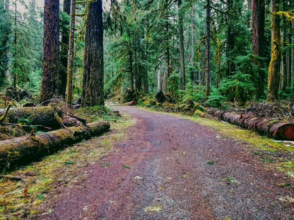
The journey is defined by its variety. The first 100 kilometres are a masterclass in "urban-adjacent" hiking, where the skyline of Manhattan remains visible even as you scale the 150-metre cliffs of the Palisades. As the trail moves north, the character shifts dramatically. In Harriman State Park, hikers encounter the rugged, rocky terrain of the Hudson Highlands. Further north, the Shawangunk Ridge offers world-class conglomerate rock formations and expansive views of the Wallkill Valley. However, the true heart of the Long Path lies in the Catskill Mountains. Here, the trail becomes a serious mountain undertaking, traversing the "Devil’s Path" and ascending several peaks over 1,000 metres. The elevation gain is relentless, with the trail often choosing the steepest possible route to reach a summit.
Logistically, the Long Path is a thru-hike of endurance. While it is shorter than the Triple Crown trails, its 26,212 metres of elevation gain over 566.4 kilometres make it exceptionally steep on a per-kilometre basis. Hikers must be prepared for "New York miles"—a local term for terrain so rocky and steep that progress is significantly slower than expected. Water management, resupply planning in small Hudson Valley towns, and navigating the occasional road walk are all part of the Long Path experience. For those who complete it, the reward is a profound understanding of New York’s natural heritage, from the tidal Hudson River to the ancient forests of the Catskills.
The concept of the Long Path was born in the 1930s, a period of great expansion for American hiking trails. It was envisioned by Vincent Schaefer, a scientist and outdoorsman who was inspired by the Long Trail in Vermont. Schaefer’s original vision was not for a strictly marked path, but rather a "path of points" that hikers would navigate between using maps and compasses. He wanted to encourage a sense of exploration and self-reliance, connecting the George Washington Bridge to the Adirondack Mountains. For decades, the Long Path remained a somewhat informal route, known only to dedicated members of the New York-New Jersey Trail Conference.
In the 1960s and 70s, the trail began to take its modern, blazed form. The NYNJTC worked tirelessly to secure easements across private land and to formalise the route through state-owned forests. This era saw the trail extended through the Catskills, arguably its most spectacular section. The history of the Long Path is inextricably linked to the history of New York’s conservation movement. Many of the parks the trail traverses, such as Harriman and the Catskill Forest Preserve, were the sites of early battles to protect wilderness from industrial development and suburban sprawl.
Culturally, the trail passes through regions of immense historical significance. The Palisades were a strategic location during the American Revolutionary War, and the Catskills were the birthplace of the Hudson River School of painting, where artists like Thomas Cole and Frederic Edwin Church captured the "sublime" nature of the American wilderness. Walking the Long Path is a journey through these layers of history. You will pass old bluestone quarries, abandoned 19th-century farmsteads, and the ruins of grand mountain hotels. The trail is a living museum of New York’s transition from a colonial frontier to an industrial powerhouse, and finally to a state that deeply values its protected wild spaces.
Want more background? Read extended notes on history and cultural context → Learn more
The Long Path is best experienced from late spring to early autumn, though each season presents a unique set of challenges and rewards. Because the trail spans a significant latitudinal and elevational range, weather conditions can vary wildly between the start in NYC and the high peaks of the Catskills.
Spring (May to June): This is a season of vibrant green and rushing water. The wildflowers in the Hudson Highlands are spectacular, and the waterfalls of the Catskills are at their most powerful. However, spring is also "mud season" in New York. The trail can be exceptionally boggy, and the infamous black flies and mosquitoes emerge in late May. Hikers should be prepared for humid days and cool nights, with temperatures ranging from 10°C to 25°C.
Summer (July to August): Summer brings stable weather but intense heat and humidity. Temperatures in the valleys can frequently exceed 30°C with high humidity levels that make physical exertion difficult. In the Catskills, the elevation provides some relief, but water sources can begin to dry up in August. This is the peak season for ticks, which are a serious concern in the tall grasses of the lower sections. Afternoon thunderstorms are common and can be violent, particularly on exposed ridges like the Shawangunks.
Autumn (September to October): Many consider this the "golden window" for the Long Path. The humidity drops, the insects disappear, and the foliage transforms into a riot of red, orange, and gold. The "leaf-peeping" season in the Catskills (usually early October) is world-famous. Daytime temperatures are a comfortable 15°C to 20°C, though night-time temperatures can drop toward freezing (0°C) in the mountains. This is the best time for high-kilometre days and crisp, clear views.
Winter (November to April): Thru-hiking the Long Path in winter is an expert-level undertaking. The Catskills receive significant snowfall, and the "Devil’s Path" section becomes a technical mountaineering route requiring crampons and ice axes. Many shelters are not insulated, and water sources freeze. While the Palisades remain walkable, the northern sections are strictly for those with advanced winter survival skills.
Stage 1: The Palisades and Hudson Highlands (NYC to Harriman)
Stage 2: Harriman State Park and the Schunemunk Mountain
Stage 3: The Shawangunk Ridge (The "Gunks")
Stage 4: The Catskill High Peaks (The Heart of the Trail)
Stage 5: The Schoharie Valley to Thacher Park
Important Notes:
Preparation for the Long Path requires a blend of wilderness skills and urban logistics. Because the trail starts in the heart of New York City, international or out-of-state hikers should fly into JFK, LGA, or EWR airports. The trailhead is accessible via the NYC Subway (A-Train to 175th St). Physical fitness is paramount; the Catskill sections are notoriously steep and will punish hikers who have not trained with a weighted pack. You should be comfortable with 15–20 km days in rugged terrain before attempting a thru-hike.
Logistical coordination involves the New York-New Jersey Trail Conference (NYNJTC). Their "Long Path Guide" is the definitive resource and should be purchased or downloaded. Unlike the Appalachian Trail, the Long Path does not have a massive "bubble" of hikers, so you will often be planning in solitude. Resupply is managed through towns like Nyack, Harriman, Wurtsboro, Phoenicia, and Hunter. Some hikers choose to mail "drop boxes" to post offices in these towns, while others rely on local grocery stores.
Accommodation on the Long Path is a mix of backcountry shelters, primitive campsites, and commercial lodging. There is no centralised booking system for the entire trail, as it passes through various jurisdictions.
Huts and Shelters:
Campsites:
Commercial Options:
For the majority of the Long Path, no formal "thru-hiking permit" is required. However, because the trail crosses a patchwork of public and private lands, hikers must adhere to specific regulations in different zones. There is no fee to start the trail at the George Washington Bridge.
Specific Permit Requirements:
Group Permits: If you are organised as a group of 10 or more, you must obtain a wilderness group permit from the DEC at least two weeks before your trip. This is to ensure that large groups do not overwhelm the fragile ecosystems of the high peaks.


Precisely traced GPX for the The Long Path, ready for your GPS or favourite mapping app.
The Long Path passes through some of New York’s most vibrant cultural and recreational hubs. Consider these diversions:
Ticks and Lyme Disease: This is the primary safety concern on the Long Path. New York has one of the highest rates of Lyme disease in the world. Deer ticks are tiny and live in tall grass and leaf litter. Prevention: Use Permethrin-treated clothing, wear long trousers tucked into socks, and perform a thorough "tick check" every evening. If you find a tick attached, remove it with tweezers and monitor for a "bullseye" rash.
Black Bears: The Catskills and Harriman are home to a healthy population of American Black Bears. While generally shy, they are highly motivated by food. Management: Use a bear-resistant canister for all food and scented items (toiletries). Never cook or eat inside your tent or shelter. If you encounter a bear, make noise, stand tall, and do not run.
Water Scarcity: On the Shawangunk Ridge and during dry summers in the Catskills, water sources can disappear. Always carry at least 3 litres of capacity and check recent hiker comments on apps like FarOut to see which springs are still flowing.
Terrain Hazards: The "Devil’s Path" section in the Catskills involves near-vertical scrambles where you must use your hands to pull yourself up. In wet weather, the sandstone and conglomerate rock becomes incredibly slippery. Head injuries from falls are a genuine risk; take your time on technical descents.
Emergency Contact: Mobile signal is spotty in the Catskill cloves. Carrying a Satellite Messenger (like a Garmin inReach) is highly recommended for thru-hikers. In an emergency, the DEC Forest Rangers are the primary search and rescue agency.
Vroman’s Nose: Located in the Schoharie Valley, this is perhaps the most "rewarding" short climb on the entire trail. The summit is a massive, flat limestone pavement that drops off precipitously, offering a bird's-eye view of the "Iroquois Breadbasket"—a patchwork of perfectly circular and rectangular farm fields. It is a geologically unique formation and a perfect spot for a long lunch.
Kaaterskill Falls: While the Long Path passes near the top, a short 1-km detour takes you to the base of this 79-metre, two-tiered waterfall. It is the highest cascading waterfall in New York and was a primary subject for Hudson River School painters. Note: This area is very popular with tourists; visit early in the morning to avoid crowds.
The Lemon Squeezer: In Harriman State Park, the trail squeezed through a narrow cleft between massive boulders. It is a rite of passage for Long Path hikers. If your pack is too wide, you may have to take it off and push it through ahead of you.
Slide Mountain Summit: As the highest point in the Catskills (1,274 m), Slide Mountain offers a sense of true alpine isolation. The summit is covered in a fragrant balsam fir forest. Look for the plaque dedicated to John Burroughs, the famous naturalist who wrote extensively about this peak.
The Long Path traverses many fragile environments, including the rare dwarf pine plains of the Shawangunks and the high-altitude boreal forests of the Catskills. These ecosystems are under intense pressure from the millions of people living nearby. Adhering to Leave No Trace (LNT) principles is not just a suggestion; it is vital for the trail's survival.
Key LNT Practices for the Long Path: