Sweden — Kiruna
Hike Sweden's Kungsleden, a 440km moderate route through Arctic wilderness. This 3-4 week traverse winds through four national parks, showcasing staggering scale and raw beauty from Abisko's birch forests to Hemavan's rolling mountains. Witness pristine tundra, glacial lakes, and rugged ridges on this iconic Swedish path.
Distance: 440.0 km
Elevation Gain: 8000 m
Difficulty: Moderate
Duration: 3-4 weeks
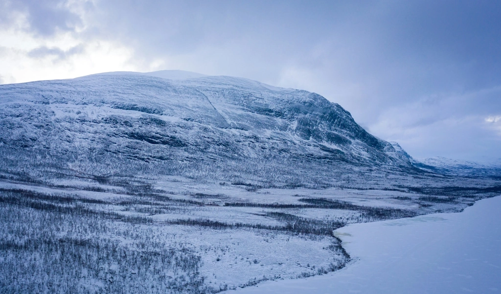
The King's Trail, or Kungsleden, is widely regarded as one of the world's most spectacular long-distance hiking routes. Stretching approximately 440 kilometres through the heart of Swedish Lapland, it traverses a landscape of staggering scale and raw, Arctic beauty. From the lush birch forests of Abisko in the north to the rolling mountains of Hemavan in the south, the trail leads hikers through four national parks—Abisko, Stora Sjöfallet, Sarek, and Pieljekaise—and the Vindelfjällen Nature Reserve. This is a land of midnight sun, ancient glaciers, deep U-shaped valleys, and the indigenous Sami people, whose reindeer herds have grazed these fells for millennia. Whether you tackle the popular northern section or commit to the full month-long thru-hike, Kungsleden offers a profound immersion into the last great wilderness of Europe.
Kungsleden was conceived at the end of the 19th century by the Swedish Tourist Association (STF) with the ambitious goal of making the Swedish mountains accessible to everyone. Today, it stands as a testament to that vision, offering a well-maintained path through some of the most rugged terrain in Scandinavia. The trail is traditionally divided into five distinct sections, each offering a unique character and varying levels of infrastructure. The northernmost stretch from Abisko to Kebnekaise is the most famous, featuring dramatic alpine scenery and a high density of mountain huts. As you move south, the trail becomes progressively quieter and more remote, particularly the sections between Kvikkjokk and Ammarnäs, where hikers must be entirely self-sufficient.
The landscape of Kungsleden is a masterclass in glacial geology. Hikers will find themselves walking through massive valleys carved by ice, past turquoise glacial lakes, and over high alpine plateaus where the wind carries the scent of crowberry and dwarf birch. The trail crosses several large lakes where rowing boats or scheduled motorboat transfers are required, adding a unique nautical element to the journey. The elevation gain, while totalling 8,000 metres over the full distance, is rarely punishingly steep; instead, the trail follows the natural contours of the valleys, making it accessible to any hiker with a good level of fitness and a sense of adventure.
One of the most defining features of Kungsleden is the "Right of Public Access" (Allemansrätten), which allows hikers to camp almost anywhere along the trail. This freedom, combined with the network of STF mountain huts spaced roughly 10 to 20 kilometres apart, provides a flexible experience. You can choose the comfort of a bunk and a wood-fired sauna at a hut, or the solitude of a tent pitched beside a rushing mountain stream. Regardless of how you choose to experience it, Kungsleden is a journey that demands respect for the Arctic environment and rewards the traveller with a sense of timelessness and peace.
The history of Kungsleden is inextricably linked with the Swedish Tourist Association (Svenska Turistföreningen or STF), founded in 1885. The idea for a "King of Trails" was first proposed in 1899 to encourage Swedes to explore their own northern wilderness. The first sections were marked in the early 1900s, and the first huts were built shortly thereafter. By the 1920s, the trail had reached its current northern extent, though it wasn't until 1975 that the southern section to Hemavan was officially inaugurated. The name "Kungsleden" was chosen to reflect the trail's status as the premier mountain route in the country.
However, the history of this land goes back much further than the trail itself. This is Sápmi, the ancestral home of the Sami people. For thousands of years, the Sami have lived in harmony with this environment, following the seasonal migrations of reindeer. As you walk the trail, you are often following ancient paths used by Sami herders. You will pass "vistes" (traditional huts) and reindeer corrals, and in the summer months, you are likely to see large herds of reindeer grazing on the high fells. It is vital for hikers to understand that this is a living cultural landscape; the reindeer are semi-domesticated animals and the backbone of the Sami economy and culture. Respecting their space and the privacy of Sami settlements is a fundamental part of the Kungsleden experience.
The trail also holds a place in modern Swedish cultural history. It was a favourite haunt of Dag Hammarskjöld, the second Secretary-General of the United Nations and a Nobel Peace Prize laureate. Hammarskjöld was an avid hiker and photographer who found spiritual solace in the Lapland mountains. His book "Markings" contains many reflections inspired by his time in these fells. Today, a series of meditation stones inscribed with his words can be found along the northern section of the trail, offering hikers a moment of quiet contemplation amidst the vast landscape.
Want more background? Read extended notes on history and cultural context → Learn more
The hiking season on Kungsleden is relatively short, dictated by the harsh Arctic climate. Most hikers visit between late June and mid-September. Each month offers a distinct experience, and choosing the right time is crucial for your enjoyment and safety.
Late June to July: This is the time of the Midnight Sun. North of the Arctic Circle, the sun never sets, providing 24 hours of daylight for hiking. The landscape is vibrant green, and wildflowers are in full bloom. However, this is also the peak of the mosquito season. The "Swedish Air Force," as the mosquitoes are jokingly called, can be relentless, especially in the birch forests and marshy areas. Snow may still linger on the high passes, and river levels can be high due to snowmelt.
August: Often considered the prime hiking month. The mosquitoes begin to thin out as the nights get cooler, and the weather is generally more stable. The berries—blueberries, cloudberries, and lingonberries—ripen, providing a delicious trailside snack. The days are still long, but you will start to see the first hints of twilight in the late evening.
September: This is the season of "höstfärger" (autumn colours). The tundra turns brilliant shades of red, orange, and gold, creating a landscape of incredible photographic beauty. The air is crisp and clear, and the first dustings of snow may appear on the peaks. This is also the best time to see the Northern Lights (Aurora Borealis) as the nights become dark enough. Be aware that many mountain huts close in mid-September, and the weather can turn wintry very quickly.
Winter (February to April): Kungsleden is also a world-class ski touring route. During these months, the trail is marked with red winter crosses. Skiers stay in the same STF huts, which are heated by wood stoves. This is a serious undertaking requiring specialized equipment and experience in Arctic winter conditions. The light in February and March is ethereal, and the silence of the frozen landscape is profound.
Section 1: Abisko to Singi (The Alpine Heart)
Section 2: Singi to Vakkotavare (The Kebnekaise Detour)
Section 3: Saltoluokta to Kvikkjokk (The Forest and Fell Mix)
Section 4: Kvikkjokk to Ammarnäs (The Wild Frontier)
Section 5: Ammarnäs to Hemavan (The Vindelfjällen Finale)
Planning a Kungsleden hike requires careful consideration of logistics, especially regarding transport and food. For the northern sections, Kiruna is the primary hub. It has an airport with daily flights from Stockholm and a train station served by the famous "Arctic Circle Train." From Kiruna, you can take a bus or train to Abisko. For the southern end, Hemavan has a small airport with flights to Stockholm, or you can take a long-distance bus to Umeå and then a train or flight.
Fitness is key; while the trail is not technically difficult, walking 15 to 25 kilometres a day with a heavy pack for multiple weeks is physically demanding. You should be comfortable navigating with a map and compass, although the trail is very well-marked with cairns and painted stones. If you plan to stay in the STF huts, becoming a member of the STF (or a partner organisation like YHA or Hostelling International) is highly recommended as it provides significant discounts on accommodation and shop prices.
The accommodation on Kungsleden is a mix of STF mountain huts (fjällstugor), mountain stations (fjällstationer), and wild camping. The system is unique and requires some understanding of the "hut culture."
STF Mountain Huts: These are simple but comfortable cabins. They do not have electricity or running water. Guests are expected to chop wood, fetch water from a nearby stream, and clean up after themselves. Most huts have a "stugvärd" (warden) who manages the facility and can provide weather updates.
Mountain Stations: Located at Abisko, Kebnekaise, Saltoluokta, Kvikkjokk, and Hemavan. These are more like hotels or hostels, offering private rooms, restaurants, showers, and electricity. These should be booked well in advance, especially during the peak months of July and August.
Wild Camping: Thanks to Allemansrätten, you can camp almost anywhere. Within national parks (like Abisko), camping is restricted to designated areas near the huts. Camping is free, but if you wish to use the hut facilities (kitchen, sauna, drying room) while camping nearby, you must pay a "service fee" to the warden.
One of the great joys of hiking in Sweden is the lack of a formal permit system. There is no "lottery" for Kungsleden, and you do not need to book a start date. This is due to the "Right of Public Access" (Allemansrätten), a unique part of Swedish law that gives everyone the right to roam freely in the countryside, provided they do not disturb or destroy.
Key points regarding access:
While no permit is required, it is highly recommended to leave your itinerary with someone at home and to sign the guestbooks in each hut you pass. This provides a record of your progress in case of an emergency.

Detailed route notes, maps, logistics & tips for the The Kings Trail Kungsleden (PDF).

Precisely traced GPX for the The Kings Trail Kungsleden, ready for your GPS or favourite mapping app.
The region surrounding Kungsleden offers numerous opportunities to deepen your Arctic experience:
Weather Awareness: The weather in the Swedish mountains can change with terrifying speed. Even in July, you can experience freezing temperatures, heavy rain, and gale-force winds. Snow is possible at any time of year on the high passes. Always check the mountain forecast (Fjällväder) at the huts before setting out. If the warden advises against crossing a pass due to high winds or low visibility, follow their advice.
River Crossings: While most major rivers are bridged, Kungsleden involves many smaller stream crossings. After heavy rain or during the early season snowmelt, these can become dangerous. Never attempt to cross a fast-flowing river that is above knee-height. Look for wider, shallower sections or wait for the water level to drop (often overnight).
Navigation in Fog: The trail is marked with cairns, but in thick fog or "whiteout" conditions, these can be impossible to see. You must be proficient with a map and compass. Do not rely solely on a GPS or smartphone, as batteries fail quickly in the cold and signal is non-existent.
Hypothermia: This is the greatest risk on Kungsleden. Wet clothing combined with wind and cold temperatures can lead to hypothermia even in summer. Always keep a set of dry base layers in a waterproof bag and put on your rain gear before you get wet.
Emergency Communication: Most STF huts are equipped with an emergency telephone (hjälptelefon) that connects directly to the police and mountain rescue. These are for life-threatening emergencies only. Outside of the huts, you are on your own; a satellite messenger is the only reliable way to call for help.
Mosquitoes: While not a direct safety threat, the psychological toll of thousands of mosquitoes can be significant. Bring a head net, use repellent, and try to camp in breezy areas away from standing water.
Skierfe: Located near the Aktse hut, the summit of Skierfe (1,179 m) offers what many consider the most beautiful view in Sweden. The cliff drops almost vertically 700 metres down to the Laitaure delta, where the Rapa River winds through a mosaic of turquoise lagoons and green islands. It is a 6–8 hour return trip from Aktse and is an absolute must-do if the weather is clear.
Tjäktja Pass: The highest point on the trail at 1,150 metres. Even if you aren't doing the full thru-hike, reaching the pass from either Sälka or Tjäktja is a highlight. The pass often holds snow well into August and provides a stark, lunar-like landscape that contrasts sharply with the green valleys below.
The Tärnasjö Bridges: In the southern section, the trail crosses the Tärnasjö lake via a series of seven wooden suspension bridges that hop between small islands. It is a unique piece of trail architecture and a great spot for photography, especially in the morning mist.
The Meditation Stones: Between Abisko and Singi, look for the stones inscribed with quotes from Dag Hammarskjöld. They are placed in spots of particular natural beauty and provide a wonderful excuse to pause and reflect on the journey.
Sälka Saunas: Many huts have saunas, but the one at Sälka is particularly famous for its location. Sitting in a hot sauna while looking out at the glaciers of the Sälka massif, followed by a dip in a freezing glacial stream, is the quintessential Kungsleden experience.
The Arctic environment is extremely fragile. The growing season is short, and tracks left in the tundra can last for decades. As a hiker on Kungsleden, you have a responsibility to uphold the principles of Allemansrätten, which is based on the motto "Do not disturb, do not destroy."
Guidelines for Kungsleden: