Dolomites Alta Via 1 (Day Section) - A Journey Through the Pale Mountains
The Dolomites Alta Via 1 is arguably the most celebrated high-altitude trekking route in the Italian Alps, stretching approximately 120 kilometres from Lago di Braies in the north to Belluno in the south. While the full traverse typically requires 10 to 12 days of sustained alpine hiking, the day section encompassing the Croda da Lago massif and the Forcella Ambrizzola offers a concentrated essence of the entire route's majesty. This 12-kilometre journey is a masterclass in geological drama, taking hikers through ancient larch forests, across high-altitude limestone plateaus, and alongside the emerald waters of Lago di Federa. It is a challenging endeavour that demands physical resilience and a keen eye for weather, but the reward is an unparalleled perspective on the UNESCO World Heritage-listed "Pale Mountains."
- Distance: 12.0 km loop/point-to-point
- Duration: 6–8 hours
- Season: July to September (peak alpine window)
- Difficulty: Challenging (significant elevation gain and technical terrain)
- Highest point: Forcella Ambrizzola (2,277 m)
- Elevation Gain: 900 m
- Closest City: Cortina d'Ampezzo, Italy
Overview
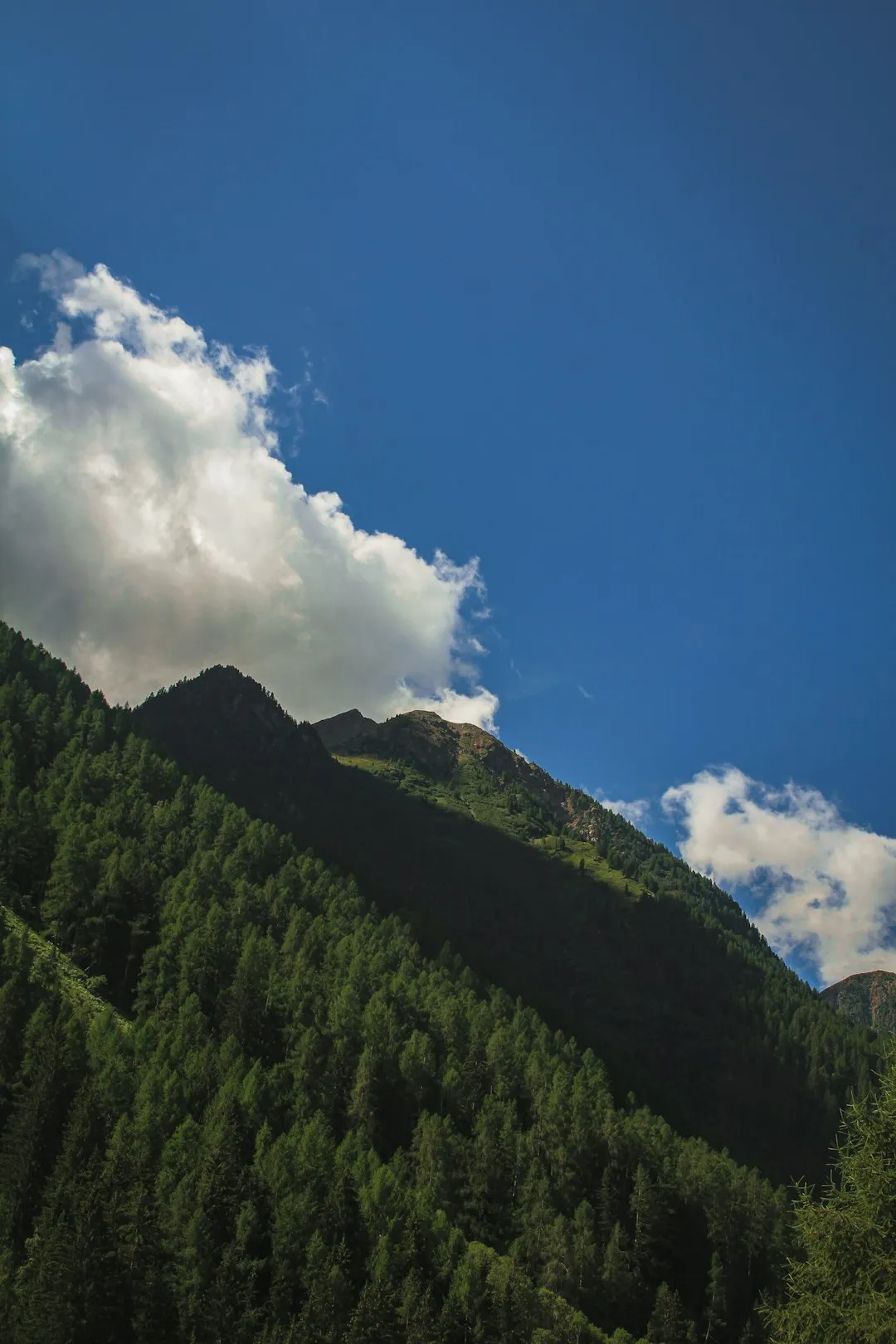
The Dolomites, a mountain range in the northern Italian Alps, are unique for their carbonate rock composition, which gives them a distinct pale appearance and the ability to glow with fiery hues of pink, orange, and purple during sunrise and sunset—a phenomenon known locally as "Enrosadira." This specific day section of the Alta Via 1 captures this magic perfectly. Starting from the trailhead near Cortina d'Ampezzo, the route ascends through the Val de Formin, a landscape defined by massive boulders and soaring vertical walls that seem to defy gravity. The terrain is a rugged tapestry of scree slopes, alpine meadows, and dense coniferous forests that have stood for centuries.
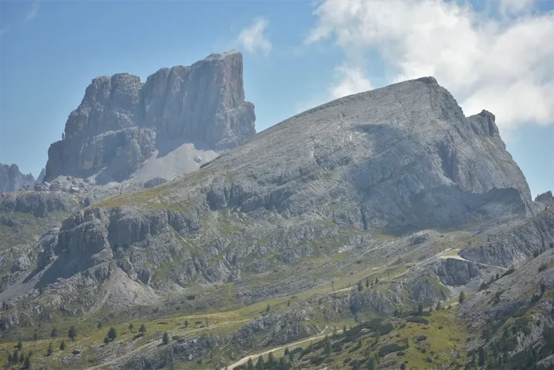
As you climb toward the Forcella Ambrizzola, the scale of the landscape becomes truly humbling. To the north, the Tofane and Cristallo massifs dominate the skyline, while to the south, the Pelmo—often called "God's Throne"—rises in a singular, massive block of stone. This section of the trail is not merely a walk; it is a transition through distinct ecological zones. You begin in the humid, shaded valleys where the scent of pine is thick, and emerge into the thin, crisp air of the high alpine, where only the hardiest wildflowers like the Edelweiss and Alpine Rose can survive. The path is well-marked but requires constant attention, as the limestone underfoot can be slippery when wet and the gradients are often unforgiving.
The emotional heart of this hike is the arrival at Lago di Federa. Nestled at the base of the Croda da Lago, this alpine lake reflects the jagged spires of the mountain in its still, clear waters. Beside it sits the Rifugio Croda da Lago (also known as Rifugio Palmieri), a sanctuary for weary hikers that embodies the warm hospitality of the Ampezzo region. Whether you are an experienced mountaineer or a fit day-hiker looking for a taste of the Alta Via 1, this section provides a profound sense of isolation and beauty that is increasingly rare in the modern world. It is a landscape that has inspired poets, climbers, and geologists for generations, and walking it is an act of immersion into one of the Earth's most spectacular natural cathedrals.
History and Cultural Context
The history of the Dolomites is as layered as the rock itself. Geologically, these mountains were formed from ancient coral reefs in the Tethys Ocean during the Triassic period, approximately 250 million years ago. The subsequent tectonic uplift and glacial erosion carved the dramatic spires and deep valleys we see today. The name "Dolomite" comes from the French mineralogist Déodat Gratet de Dolomieu, who was the first to describe the unique magnesium-rich limestone that defines the range. For the local Ladin people, however, these mountains have always been more than just rock; they are the setting for a rich oral tradition of myths and legends involving mountain spirits, giants, and enchanted kingdoms.
In more recent history, this region was a primary front during the First World War. Between 1915 and 1917, the Italian and Austro-Hungarian armies engaged in a brutal "War of the Peaks," fighting for control of high-altitude passes and summits. The Alta Via 1 passes through areas where soldiers carved tunnels into the rock, built precarious supply lines (the precursors to modern via ferrata), and endured unimaginable conditions. While this specific day section near Croda da Lago was less of a direct combat zone than the nearby Lagazuoi or Cinque Torri, the entire landscape is a memorial to that conflict. You may still find rusted remnants of barbed wire or old stone fortifications tucked away in the scree.
The cultural identity of the region is a blend of Italian, Austrian, and Ladin influences. This is reflected in the bilingual (and often trilingual) signage, the architecture of the rifugios, and the local cuisine. The establishment of the Alta Via 1 in the 1960s was a pivotal moment in mountain tourism, designed to connect the various rifugios and provide a continuous high-level route across the range. Today, the trail is a symbol of European unity and a shared passion for the alpine environment. It is managed with a deep respect for tradition, ensuring that the "rifugio culture"—where hikers of all backgrounds share a table and a meal—remains the cornerstone of the experience.
Want more background? Read extended notes on history and cultural context → Learn more
Seasonal Highlights and Weather Reality
The window for hiking the high-altitude sections of the Alta Via 1 is relatively narrow, dictated by the presence of snow and the operational dates of the mountain huts. The primary season runs from early July to late September. Outside of this period, the trail can be dangerous or impassable for those without advanced winter mountaineering skills and equipment.
July and August: These are the warmest months, with long daylight hours and vibrant alpine meadows in full bloom. However, this is also the period of peak popularity, and the trails can be crowded. More importantly, the Dolomites are prone to violent afternoon thunderstorms in mid-summer. These storms often develop rapidly after 2:00 PM, bringing heavy rain, lightning, and sudden temperature drops. Hikers should aim for early starts to be off the high passes or at a rifugio before the clouds build up.
September: Many experienced hikers consider September the "golden month" in the Dolomites. The air is crisper and clearer, providing the best visibility for photography. The crowds begin to thin, and the larch trees start to turn a brilliant gold toward the end of the month. While the days are shorter and the nights are colder (often dropping below freezing at altitude), the weather is generally more stable than in July or August. However, early autumn snowfalls are possible, so checking the forecast is essential.
Winter and Shoulder Seasons: From October to June, the trail is often buried under metres of snow. Avalanche risk is a significant concern on the steep slopes of the Val de Formin and around the Forcella Ambrizzola. Most rifugios close by late September or early October, leaving no emergency shelter or facilities available. Hiking during this time is strictly for experts equipped with ice axes, crampons, and avalanche safety gear.
Recommended Itinerary
Dolomites Alta Via 1: Croda da Lago Day Loop
Phase 1: Early Morning - The Ascent from Ponte de Ru Curto
- Distance: 3.5 km
- Elevation gain: 450 m
- Time: 1.5–2 hours
- Start at the Ponte de Ru Curto trailhead (1,708 m) on the road between Cortina and Passo Giau
- Follow Trail 437 through a dense forest of spruce and larch
- The path is well-maintained but begins with a steady, heart-pumping incline
- Reach the junction with Trail 434, which leads toward the Croda da Lago massif
- The forest begins to thin, offering the first glimpses of the jagged peaks above
Phase 2: Morning - Traversing the Val de Formin
- Distance: 3 km
- Elevation gain: 350 m
- Time: 1.5–2 hours
- Enter the high alpine basin of Val de Formin
- The terrain becomes more rugged, with large limestone boulders and scree sections
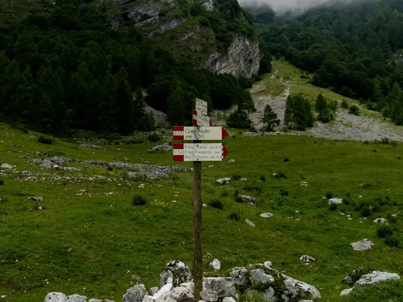
- Follow the markers carefully as the trail weaves through the rock garden
- The ascent steepens as you approach the Forcella Ambrizzola
- Keep an eye out for chamois (mountain goats) often seen on the higher slopes
- Arrive at Forcella Ambrizzola (2,277 m), the highest point of the hike
Phase 3: Midday - The High Plateau and Forcella Ambrizzola
- Distance: 1 km (exploration time)
- Elevation: Minimal
- Time: 1 hour (including lunch)
- Take time to absorb the 360-degree views from the pass
- To the south, the massive Monte Pelmo dominates the horizon
- To the east, the peaks of the Sorapiss and Antelao are visible
- This is the perfect spot for a packed lunch, provided the wind is not too strong
- The pass marks the boundary between the Ampezzo valley and the Val di Zoldo
Phase 4: Afternoon - Descent to Lago di Federa and Return
- Distance: 4.5 km
- Elevation: 800 m descent
- Time: 2–3 hours
- Descend from the pass toward the shimmering Lago di Federa
- The trail drops quickly through alpine meadows before reaching the lakeshore
- Visit Rifugio Croda da Lago (Palmieri) for a well-earned coffee or slice of strudel
- Follow Trail 434 back down toward the forest
- The descent is steep in sections and can be taxing on the knees; trekking poles are highly recommended
- Rejoin the initial forest path and return to the Ponte de Ru Curto trailhead
Important Notes:
- The route can be done in either direction, but ascending via Val de Formin is generally preferred for the views
- Ensure you have a physical map (Tabacco Map 03 is best) as GPS can be spotty in deep valleys
- The Rifugio Croda da Lago is usually open from mid-June to late September
- Parking at Ponte de Ru Curto is limited; arrive before 8:30 AM in peak season
- Water sources are scarce on the high plateau; carry at least 2 litres
Planning and Bookings
Book Your Trip
Everything you need to plan your journey
Accommodation
Find places to stay near Cortina d'Ampezzo
Flights
Search flights to Cortina d'Ampezzo
Essential Preparation
Preparation for a day section of the Alta Via 1 begins with physical conditioning. While 12 kilometres may sound modest, the 900 metres of elevation gain on rugged, uneven terrain makes this a strenuous outing. Hikers should be comfortable with steep ascents and descents and have experience walking on loose scree. If you are staying in Cortina d'Ampezzo, use the town as your base for logistics. Cortina has numerous outdoor shops where you can buy maps, fuel, or last-minute gear. It is also the hub for the local bus system (Dolomiti Bus), which can sometimes provide transport to trailheads, though a car or taxi is often more reliable for the Ponte de Ru Curto start point.
Booking coordination is less critical for a day hike than for the full multi-day trek, but if you plan to eat a full meal at Rifugio Croda da Lago, it is worth checking their opening status. For those wishing to stay overnight at the rifugio to catch the sunrise, bookings must be made months in advance, as it is one of the most popular huts on the entire Alta Via 1 route.
Trail Accommodation
This is primarily a day hike, but the Rifugio Croda da Lago (Palmieri) is the central accommodation point for this section. It is a traditional mountain hut managed by the CAI (Club Alpino Italiano).
Hut Facilities:
- Dormitory-style bunk beds and a few private rooms
- Shared bathroom facilities with limited hot water (often requires a token)
- A restaurant serving traditional Ampezzo cuisine (polenta, casunziei, strudel)
- A large outdoor terrace overlooking Lago di Federa
- Charging stations for phones (limited and often crowded)
- Blankets and pillows are provided, but a silk or cotton sleeping bag liner is mandatory
What Huts Don't Provide:
- Towels or toiletries
- Free WiFi (signal is very weak or non-existent)
- Unlimited electricity
- Private showers in most cases
Booking Requirements:
- Bookings are essential for overnight stays and should be made via email or their website
- Costs for half-board (dinner, bed, and breakfast) typically range from €70 to €90 per person
- CAI members receive a significant discount on the bed night cost
Required Gear
- Mountain boots: High-cut boots with a stiff sole and good grip (Vibram or similar) are essential for the scree and rock
- Trekking poles: Highly recommended to save your knees on the 800 m descent and provide stability on loose ground
- Layered clothing: A moisture-wicking base layer, a fleece or down mid-layer, and a high-quality waterproof shell
- Backpack: A 20–30 litre daypack with a proper hip belt and rain cover
- Navigation: A physical map (Tabacco 03), a compass, and a GPS app with offline maps (e.g., Gaia GPS or AllTrails)
- Sun protection: High-factor sunscreen, sunglasses with UV protection, and a wide-brimmed hat
- Head torch: Even on a day hike, always carry one in case of delays
What to Bring
- Water: At least 2 litres per person; there are no reliable water sources between the trailhead and the rifugio
- High-energy snacks: Trail mix, energy bars, and fruit to maintain blood sugar levels during the steep climb
- First aid kit: Include blister plasters (Compeed), antiseptic wipes, bandages, and any personal medication
- Emergency shelter: A lightweight foil bivy bag or space blanket
- Cash: Many rifugios prefer cash for small purchases like coffee or snacks, as card machines can fail at altitude
- Identification: Always carry a form of ID and your insurance details
- Mobile phone: Fully charged, but kept in airplane mode to save battery
Permits
One of the great appeals of hiking in the Italian Dolomites is the lack of a formal permit system for the trails themselves. Unlike many national parks in North America or New Zealand, you do not need to apply for a permit to walk the Alta Via 1 or its day sections. The mountains are open to all, reflecting a long-standing European tradition of freedom of movement in the alpine environment.
Key Considerations:
- No Trail Fees: There are no entry fees for the Dolomites UNESCO World Heritage area or the specific trails around Croda da Lago.
- Rifugio Bookings: While the trail is free, the infrastructure is not. If you intend to stay overnight, the "permit" is effectively your confirmed reservation at the rifugio. These sell out months in advance for the July–August period.
- Parking Fees: Some trailheads, particularly those closer to major passes like Passo Giau, may have small parking fees during the peak season. At Ponte de Ru Curto, parking is currently free but extremely limited.
- Group Sizes: There are no strict limits on group sizes for day hikers, but large groups (10+) should be mindful of their impact on the trail and other hikers' experiences.
- Drone Regulations: The use of drones is strictly regulated in the Dolomites. In many areas, it is completely prohibited to protect wildlife and the privacy of other hikers. Always check local ENAC (Italian Civil Aviation Authority) regulations before flying.
Logistics and Transport:
- Car Rental: The most flexible way to reach the trailhead from Venice or Treviso airports. Ensure your rental has a transponder for the Italian motorway tolls (Telepass).
- Public Transport: The Cortina Express and ATVO buses connect Venice to Cortina. From Cortina, local buses run toward Passo Giau, but schedules are seasonal and sometimes infrequent.
- Taxis: Local taxis in Cortina are familiar with the trailheads and can be a good option for point-to-point hikes, though they are relatively expensive (expect to pay €40–€60 for a short drop-off).
Other Activities in the Area
The region surrounding Cortina d'Ampezzo is an outdoor playground with activities to suit all levels of adventure:
- Via Ferrata: The Dolomites are the birthplace of the "Iron Path." Nearby routes like the Via Ferrata degli Alpini on the Col dei Bos or the easier routes at Cinque Torri offer a thrilling way to experience the vertical world.
- Cinque Torri Open-Air Museum: A short drive or lift ride from the trailhead, this area features restored WWI trenches and bunkers set amidst five iconic rock towers. It is both a historical site and a world-class rock climbing destination.
- Mountain Biking: Cortina offers an extensive network of lift-accessed mountain bike trails, ranging from gentle valley paths to technical downhill runs.
- Lagazuoi Tunnels: Explore the incredible network of tunnels carved into the mountain by Italian soldiers during WWI. A head torch and helmet are essential for this dark, damp, and moving experience.
- Cortina d'Ampezzo Town: Known as the "Queen of the Dolomites," the town itself is worth exploring for its high-end boutiques, excellent restaurants, and the Mario Rimoldi Modern Art Museum.
- Lago di Sorapiss: Another iconic day hike near Cortina, famous for its startlingly turquoise glacial water. It is a popular and challenging alternative to the Croda da Lago circuit.
Safety and Conditions
Pre-Departure Checks:
- Check the local ARPA Veneto mountain weather forecast, which is the most accurate for this specific region.
- Consult the "Bollettino Meteo" posted at the Cortina Mountain Guides office or at local rifugios.
- Ensure someone knows your planned route and expected return time; mobile signal is unreliable in the Val de Formin.
- Verify the status of the trails; early season hikers should check if the Forcella Ambrizzola is clear of snow.
Alpine Hazards: The Dolomites are serious mountains, and conditions can change in minutes. The most significant risks on this section include lightning (stay off the ridges and passes if a storm approaches), rockfall (common on the steep limestone walls above Val de Formin), and slips on wet rock or loose scree. The descent from Forcella Ambrizzola to Lago di Federa is particularly prone to being slippery after rain. Hypothermia is a risk even in summer if you are caught in a storm without adequate waterproof layers; temperatures can drop from 20°C to 5°C in a matter of minutes during a thunderstorm.
Navigation: While the Alta Via 1 is marked with the iconic "1" inside a triangle, and local trails use red-and-white painted stripes, it is easy to become disoriented in low visibility. Cloud can descend rapidly, turning a clear path into a confusing landscape of grey rock. Always carry a compass and know how to use it in conjunction with your map. Do not rely solely on a smartphone, as cold temperatures can drain batteries quickly.
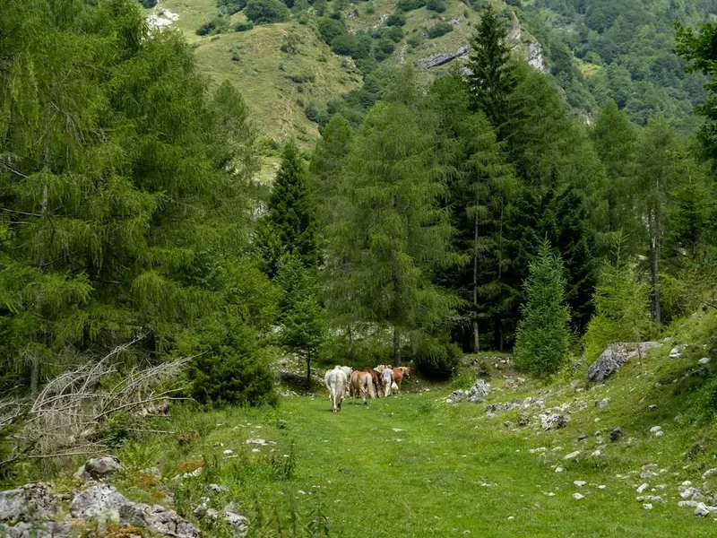
Wildlife and Environment: Respect the local wildlife. While chamois and marmots are common, they should be observed from a distance. Ticks can be present in the lower forested sections (Trail 437), so check your legs after the hike. Adders (venomous snakes) are occasionally found on sun-warmed rocks; they are shy and will usually move away if they hear you coming, but watch where you step and place your hands.
Emergency Services: In the event of an accident, the emergency number in Italy is 112. Mountain Rescue (Soccorso Alpino) is highly professional but expensive if you do not have insurance that covers search and rescue. It is strongly recommended to have a policy that specifically includes "mountain activities" and "helicopter evacuation."
Side Trips and Points of Interest
Lago di Federa: This is the undisputed highlight of the hike. The lake is one of the few in the Dolomites that is not fed by a visible stream, instead relying on underground springs. Its depth and clarity make it a perfect mirror for the Croda da Lago. In late September, the surrounding larch trees turn a fiery orange, creating one of the most photographed scenes in the Alps. A slow walk around the entire perimeter of the lake takes about 30 minutes and offers various perspectives on the Becco di Mezzodì peak.
Becco di Mezzodì: For those with extra energy and scrambling experience, a faint path leads from Forcella Ambrizzola toward the base of this iconic "Midday Peak." While the summit itself requires technical climbing, the views from its base are even more expansive than from the pass. It is named because, when viewed from Cortina, the sun sits directly above it at noon.
Cason di Formin: Located in the heart of the Val de Formin, this is a natural amphitheatre of rock. It is a place of profound silence, where the only sound is the occasional whistle of a marmot or the clatter of falling stone. The scale of the vertical walls here is a powerful reminder of the geological forces that shaped the Dolomites.
The Larch Forests: The lower sections of the trail pass through some of the finest larch and stone pine forests in the Ampezzo valley. These trees are incredibly hardy, with some individuals estimated to be several hundred years old. The forest floor is a carpet of mosses and ferns, providing a lush contrast to the stark rock of the high alpine. In spring, look for the rare Lady's Slipper Orchid in the shaded areas.
Leave No Trace
The Dolomites are a UNESCO World Heritage site, a designation that recognises their exceptional natural beauty and geological importance. With millions of visitors each year, the impact on the environment is significant. Every hiker has a responsibility to minimise their footprint to ensure these mountains remain pristine for future generations.
Your responsibility as a walker:
- Carry Out All Trash: This includes organic waste like banana peels or apple cores, which decompose very slowly in the cold, high-altitude environment.
- Stay on Marked Trails: Short-cutting switchbacks causes severe soil erosion and destroys fragile alpine vegetation. The limestone soil is thin and takes decades to recover from trampling.
- Respect Water Sources: Do not use soap or detergents in Lago di Federa or any alpine streams. Even biodegradable soaps can harm sensitive aquatic ecosystems.
- No Wild Camping: Wild camping is strictly prohibited in the Dolomites. You must stay in designated rifugios or down in the valley campsites. This regulation is strictly enforced to prevent fire risk and waste issues.
- Leave What You Find: Do not pick wildflowers or take rocks as souvenirs. The "Pale Mountains" should stay exactly where they are.
- Be Quiet and Considerate: Sound travels far in the thin mountain air. Avoid shouting or playing music, allowing everyone to enjoy the natural silence of the peaks.
By following these principles, you contribute to the preservation of a landscape that is not just an Italian treasure, but a global one. Tread lightly and respect the "Spirit of the Dolomites."