Teide Summit Trail - A Volcanic Ascent
The Teide Summit Trail is a challenging yet immensely rewarding day hike on Tenerife, the largest of Spain's Canary Islands. This trail leads to the highest point in Spain, the summit of Mount Teide, a stratovolcano that dominates the island's landscape. Standing at 3,718 metres, Teide offers unparalleled panoramic views across Tenerife and, on exceptionally clear days, to the neighbouring islands of La Gomera, El Hierro, and Gran Canaria. The ascent takes you through a dramatic, otherworldly volcanic terrain, showcasing a unique ecosystem adapted to harsh conditions. This is a journey into the heart of a dormant giant, a testament to geological power and the resilience of life.
- Distance: 9.0 km (one-way to summit)
- Elevation gain: 1,400 m
- Duration: 5–7 hours (round trip)
- Season: May to October (best for clear skies and moderate temperatures)
- Huts: None (day hike)
- Highest point: Pico del Teide (3,718 m)
- Difficulty: Challenging
- Closest City: La Orotava
- Trailhead Access: Montaña Blanca (via TF-21 road)
- Permit: Summit permit required for access to the final 200m to the peak
Overview
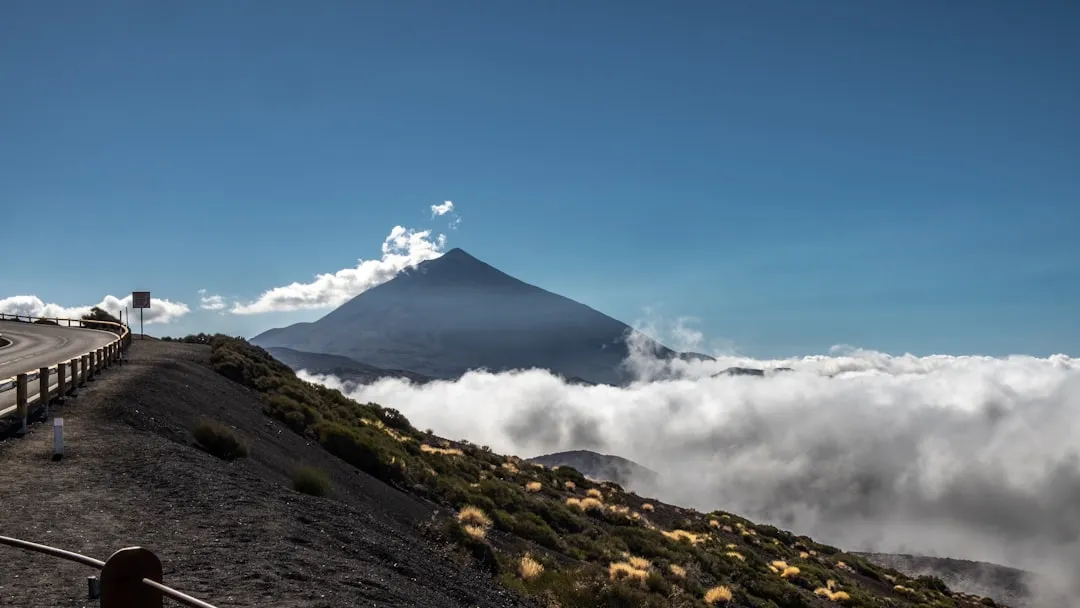
The Teide Summit Trail is not merely a hike; it's an immersion into a starkly beautiful volcanic landscape that feels more akin to the surface of Mars than Earth. The journey begins at Montaña Blanca, a popular starting point accessible by road, where the air is already thin and the vegetation sparse. From here, the trail ascends relentlessly, a steep and demanding climb that tests both physical endurance and mental fortitude. The path winds through fields of volcanic ash, solidified lava flows, and bizarre rock formations sculpted by millennia of wind and weather. As you gain altitude, the views expand dramatically, revealing the vast caldera of Teide National Park stretching out below, a surreal expanse of craters, cones, and ancient lava rivers.
The trail is primarily a gravel and scree path, often steep and loose underfoot, requiring sturdy hiking boots and careful navigation. The altitude is a significant factor; by the time you reach the upper sections, the air is noticeably thinner, and exertion can feel much more profound. The final ascent to the summit itself is a short, steep climb, often via a well-maintained path or a series of steps, leading to the crater rim. From the summit, the 360-degree vista is breathtaking. On a clear day, you can see the entire island laid out beneath you, the Atlantic Ocean stretching to the horizon, and the silhouettes of other Canary Islands in the distance. The sheer scale of the landscape, combined with the unique geological features, makes this a truly unforgettable experience.
The trail is best tackled in the cooler months or during the shoulder seasons to avoid the intense summer heat at lower elevations and potential snow at the summit in winter. The unique flora and fauna, adapted to this extreme environment, are also a point of interest, with endemic species found nowhere else on Earth. This hike is a journey to the roof of Spain, offering a profound connection with nature's raw power and beauty.
History and Geological Significance
Mount Teide is a stratovolcano, meaning it is built up from many layers of hardened lava, tephra, pumice, and volcanic ash. Its current form is the result of a massive eruption approximately 200,000 years ago, which caused the collapse of the original volcano, forming the vast Las Cañadas caldera. Teide itself then grew within this caldera. The last significant eruption occurred in 1909, but the volcano is considered dormant, not extinct, with geothermal activity still evident in the form of fumaroles and hot springs in the surrounding area.
The geological history of Teide is a story of immense volcanic power and continuous transformation. The unique landscape of Teide National Park, a UNESCO World Heritage Site since 2007, is a direct result of these volcanic processes. The park preserves an exceptional array of volcanic formations, including lava flows, craters, and the distinctive "Roques de García," a series of striking rock pillars that stand as sentinels in the caldera.
Human interaction with Teide dates back to the indigenous Guanche people, who inhabited the Canary Islands before the arrival of Europeans. The Guanches revered Teide, which they called "Echeyde," meaning "heaven." They believed it was a prison for an evil demon, Guayota, who was trapped inside by the sun god. The summit was a sacred place, and archaeological evidence suggests it was used for rituals. Later, during the Spanish colonial period, Teide continued to fascinate explorers and scientists. Its height and unique geological features made it a prime location for astronomical observation, leading to the establishment of the Teide Observatory, one of the world's leading solar observatories, situated on the slopes of the volcano.
The development of the TF-21 road in the 20th century made the summit more accessible, transforming it from a remote pilgrimage site into a popular tourist destination and a challenging hiking objective. The establishment of Teide National Park in 1954 further protected its unique environment and geological heritage, ensuring its preservation for scientific study and public appreciation.
Seasonal Considerations and Weather
The best time to hike the Teide Summit Trail is generally from May to October. During these months, the weather is typically more stable, with longer daylight hours and a lower chance of snow or ice at the summit. However, even in summer, the altitude means temperatures can be cool, especially in the early morning and late afternoon.
Spring (April-May): Pleasant temperatures, with blooming endemic flora in the lower sections of the park. Snow may still be present at the highest elevations in early spring. Days are getting longer, offering ample time for the hike.
Summer (June-August): This is the warmest period, but also the busiest. The summit can still be cool, but the lower elevations can become very hot. The air is often clearest, offering excellent visibility for panoramic views. However, afternoon cloud build-up is common, which can obscure views and bring cooler temperatures.
Autumn (September-October): Similar to spring, autumn offers pleasant temperatures and good visibility. The crowds begin to thin out after the summer holidays, making for a more tranquil hiking experience. The colours of the sparse vegetation can also be striking.
Winter (November-March): While technically possible, winter hiking to the summit is for experienced individuals with appropriate gear. Snow and ice are common at higher altitudes, and temperatures can drop significantly below freezing. The summit may be inaccessible due to weather conditions. The Teide Observatory often experiences heavy snowfall. If attempting in winter, check conditions meticulously and be prepared for alpine conditions.
Weather Phenomena: Teide is known for its dramatic weather changes. Clouds can form rapidly, leading to reduced visibility and sudden drops in temperature. Strong winds are also common, particularly at higher elevations. The "mar de nubes" (sea of clouds) phenomenon, where clouds fill the lower valleys and caldera, is a spectacular sight but can obscure the ground-level landscape.
Recommended Itinerary
Teide Summit Trail - Day Hike Itinerary
Early Morning (Approx. 7:00 AM - 8:00 AM): Arrival and Preparation
- Drive to Montaña Blanca trailhead (2,350 m). Nearest airport is Tenerife South (TFS). Take bus 343 to La Orotava, then a taxi or local bus to Montaña Blanca. Driving is the most direct route via the TF-21 road.
- Parking is available but limited, especially during peak season. Arrive early to secure a spot.
- Final gear check: ensure you have water, food, warm layers, sun protection, and your summit permit (if applicable).
- Acclimatise to the altitude for a few minutes.
Morning (Approx. 8:00 AM - 12:00 PM): Ascent to La Rambleta
- Begin the hike from Montaña Blanca. The trail is clearly marked and ascends steadily.
- The path is primarily loose scree and volcanic gravel, requiring good ankle support and careful footing.
- Pass through a stark, volcanic landscape with minimal vegetation. Observe unique rock formations and lava flows.
- The gradient is steep, averaging around 15-20% in many sections.
- You will pass the upper station of the Teleférico (cable car) at La Rambleta (3,555 m). This is a good point for a break and to assess your condition.
- The final 200 metres to the summit crater rim require a specific permit. If you have this, continue towards the summit access point.
Midday (Approx. 12:00 PM - 2:00 PM): Summit and Views
- Reach the summit crater rim (3,718 m).
- If you have the summit permit, you can access the very peak via a short, well-maintained path.
- Spend time enjoying the unparalleled 360-degree views. Identify the other Canary Islands on a clear day.
- Take photographs and appreciate the vastness of the caldera below.
- Have your packed lunch and rehydrate. Be mindful of the thin air and potential for rapid weather changes.
Afternoon (Approx. 2:00 PM - 5:00 PM): Descent and Return
- Begin your descent back to Montaña Blanca. The descent is often faster but can be harder on the knees due to the loose scree.
- Take care with your footing to avoid slips and falls.
- You can opt to use the Teleférico from La Rambleta down to the lower station (near the Parador Nacional) if you wish to shorten the descent, but this requires a separate ticket and does not go all the way to Montaña Blanca. From the Teleférico lower station, you would need to arrange transport back to your vehicle.
- Continue descending on foot to Montaña Blanca.
- Upon reaching Montaña Blanca, you have completed the challenging ascent.
Important Notes:
- The summit permit is essential for accessing the final 200m to the peak. Book well in advance.
- The Teleférico is an alternative to hiking the entire ascent/descent but does not go to Montaña Blanca.
- Carry at least 2-3 litres of water per person.
- Wear sturdy, broken-in hiking boots.
- Sun protection (hat, sunglasses, high SPF sunscreen) is crucial due to the high altitude and strong sun.
- Layered clothing is recommended, as temperatures can vary significantly.
Planning and Bookings
Book Your Trip
Everything you need to plan your journey
Accommodation
Find places to stay near La Orotava
Flights
Search flights to La Orotava
Essential Preparation
The Teide Summit Trail is a demanding day hike that requires careful planning. The most critical element is securing a summit permit, which is mandatory for the final 200 metres to the peak. These permits are limited and must be booked in advance through the official Spanish National Parks website (reservasparquesnacionales.es). Without this permit, you can hike to the upper station of the cable car (La Rambleta) but cannot reach the absolute summit.
Physical fitness is paramount. The trail involves a significant elevation gain of 1,400 metres over approximately 4.5 km (one-way), meaning a very steep gradient. Hikers should have a good level of cardiovascular fitness and be accustomed to strenuous uphill walking. Acclimatisation to altitude is also important; spending a day or two at lower elevations on Tenerife before attempting the summit can be beneficial.
Logistics for reaching the trailhead at Montaña Blanca are also key. The nearest major town with comprehensive services is La Orotava. From La Orotava, you can take a taxi or a local bus service to Montaña Blanca. Driving your own vehicle is the most convenient option, with parking available at the trailhead, though it can be limited. Ensure your vehicle is in good condition for mountain roads.
Trail Accommodation
This is a day hike requiring no overnight accommodation.
Required Gear
- Hiking Boots: Sturdy, waterproof hiking boots with good ankle support are essential. The terrain is loose scree and volcanic gravel, requiring excellent grip and stability. Ensure they are well broken-in to prevent blisters.
- Backpack: A comfortable daypack (20-30 litres) is sufficient for carrying essentials.
- Navigation: While the trail is generally well-marked, a map, compass, or GPS device with an offline map of the area is recommended, especially for understanding the route and potential alternative paths.
- Head Torch: Essential for early morning starts or if your hike extends beyond daylight hours. Carry spare batteries.
- First Aid Kit: A comprehensive kit including blister treatment, pain relievers, antiseptic wipes, bandages, and any personal medications.
- Sun Protection: High SPF sunscreen (50+), a wide-brimmed hat, and sunglasses are crucial due to the intense sun at high altitude and potential for reflection off snow.
- Trekking Poles: Highly recommended for both the ascent and descent. They significantly reduce strain on knees and ankles and improve stability on loose terrain.
- Waterproof/Windproof Jacket: Weather can change rapidly at altitude. A lightweight, breathable waterproof and windproof jacket is vital.
What to Bring
- Water: Carry at least 2-3 litres of water per person. There are no water sources on the trail. Dehydration is a serious risk at altitude.
- Food: High-energy snacks and a packed lunch are essential. Think nuts, dried fruit, energy bars, sandwiches. You will need sustenance for a long, strenuous day.
- Warm Layers: Even in summer, temperatures at the summit can be cool (around 10-15°C, potentially lower with wind chill). Bring a fleece or insulated jacket, and consider thermal base layers for early morning starts.
- Gloves and Beanie: Recommended, especially for early morning starts or if hiking outside of peak summer.
- Toiletries: Hand sanitiser, tissues.
- Camera: To capture the incredible scenery.
- Identification and Permit: Carry your passport or ID and your printed summit permit.
Permits
Access to the final 200 metres of the Teide summit, leading to the crater rim and the peak itself, requires a permit. This is a mandatory requirement enforced by the Spanish National Parks authority to manage visitor numbers and protect the fragile environment at the highest point of the volcano.
How to Obtain a Summit Permit:
- Online Booking: Permits must be booked in advance through the official Spanish National Parks website: reservasparquesnacionales.es.
- Booking Window: Permits are released on a rolling basis, typically several weeks or months in advance. It is highly recommended to book as early as possible, especially for peak season (summer months and holidays), as they are limited and highly sought after.
- Free of Charge: The summit permit itself is free of charge. However, you may need to pay for associated services if you book through a third-party tour operator.
- Identification: You will need to provide personal identification details when booking. Ensure the name on your permit matches your identification, as you may be asked to present it.
- Teleférico Users: If you plan to use the cable car (Teleférico) for part of your ascent or descent, you will need a separate ticket for the cable car. The summit permit is still required to access the final section of the peak, even if you use the cable car to reach La Rambleta.
Important Considerations:
- Limited Availability: The number of permits issued daily is strictly limited. Failure to book in advance means you will likely be unable to reach the summit.
- Flexibility: If your travel dates are flexible, try to book for weekdays or shoulder seasons when demand might be slightly lower.
- Check Conditions: Always check the weather forecast and park conditions before your hike. If the park is closed due to extreme weather, your permit may be invalidated.
Other Activities in the Area
Teide National Park and its surroundings offer a wealth of activities beyond the summit hike:
- Teleférico de Teide: Ride the cable car from its lower station (near the Parador Nacional) up to La Rambleta (3,555 m). This offers spectacular views and access to the start of the summit trail (if you have a permit) or shorter walking trails.
- Roques de García: A striking collection of rock formations in the caldera, including the iconic "Cinchado" (the finger-shaped rock). Easily accessible from the Parador Nacional, these offer fantastic photographic opportunities and a sense of the park's unique geology.
- Observatorio del Teide: Visit the world-renowned Teide Observatory. While direct access to the telescopes is restricted, there are visitor centres and guided tours that explain the astronomical research conducted here.
- Hiking Trails within the Park: Numerous other trails explore the caldera and surrounding volcanic landscapes, ranging from short interpretive walks to multi-hour treks. Examples include the trail to Pico Viejo viewpoint and the trail around the base of the Roques de García.
- Stargazing: Teide National Park is recognised as one of the best places in the world for stargazing due to its high altitude, clear skies, and minimal light pollution. Guided stargazing tours are available.
- Exploring La Orotava: The nearby town of La Orotava offers a charming historic centre with traditional Canarian architecture, beautiful gardens (like the Hijuela del Botánico), and a rich cultural heritage.
- Driving the TF-21: The scenic road that winds up to the park offers breathtaking views at every turn, with numerous viewpoints and picnic spots along the way.
Safety and Conditions
Altitude Sickness: The most significant safety concern is altitude sickness. Symptoms can include headache, nausea, dizziness, and fatigue. Ascend gradually, stay hydrated, and avoid strenuous activity on your first day at altitude. If symptoms worsen, descend immediately.
Weather: Teide's weather can change rapidly. Be prepared for strong winds, sudden cloud cover, and significant temperature drops, even in summer. Always check the mountain forecast before you go and carry appropriate layers.
Terrain: The trail is steep, loose, and can be slippery, especially on the descent. Wear sturdy hiking boots and use trekking poles for stability. Take your time and watch your footing.
Sun Exposure: The sun's rays are intense at high altitude. Use high SPF sunscreen, wear a hat and sunglasses, and stay hydrated to prevent sunburn and heatstroke.
Hydration and Nutrition: Carry ample water (2-3 litres per person) and high-energy food. There are no facilities on the trail. Dehydration and lack of energy can exacerbate altitude sickness and impair judgment.
Teleférico Status: Check the operational status of the Teide cable car in advance, as it can be closed due to high winds or maintenance. This will affect your descent options if you planned to use it.
Emergency Services: In case of emergency, contact the park rangers or the emergency services. The park has ranger patrols, and emergency numbers are posted at trailheads and visitor centres.
Permit Compliance: Ensure you have your summit permit if you intend to reach the peak. Rangers patrol the summit access points and will check permits.
Side Trips and Points of Interest
Pico Viejo Viewpoint: Located near the upper station of the Teleférico, this viewpoint offers stunning vistas into the vast caldera of Pico Viejo, a secondary crater formed by a massive eruption. The colours and scale of the volcanic landscape here are immense, and on clear days, you can see across to the other islands.
La Fortaleza: A distinctive, flat-topped volcanic plug that stands out in the caldera. It's a prominent landmark and offers a sense of the dramatic geological forces that shaped the park.
Montaña Blanca: The starting point of the main summit trail. This area is characterised by its white volcanic sand and the beginning of the steep ascent. It's a good place to take your first photos and get a sense of the scale of the climb ahead.
Teleférico Lower Station Area: Even if you don't ride the cable car, the area around its lower station offers access to interpretive trails and information boards about the park's geology and history. It's also a good spot to observe the unique flora adapted to the volcanic soil.
Fumaroles: As you ascend, you may notice small vents emitting steam or gases, indicating the ongoing geothermal activity beneath the surface. These are a reminder of the volcano's dormant power.
Leave No Trace
The Teide Summit Trail traverses a fragile volcanic ecosystem within a UNESCO World Heritage Site. Adhering to Leave No Trace principles is crucial to preserving this unique environment for future visitors and for scientific study.
Stay on the Trail: The volcanic scree and sparse vegetation are easily damaged. Stick strictly to marked paths to avoid trampling delicate plants and causing erosion. The ground can be unstable off-trail.
Pack It In, Pack It Out: Carry out all your litter, including food scraps, wrappers, and any other waste. There are no bins on the trail. Ensure you leave the environment as you found it.
Respect Wildlife: While life is sparse at these altitudes, observe any wildlife from a distance. Do not feed any animals, as this can disrupt their natural behaviour and diet.
Dispose of Waste Properly: Use designated toilets at the trailhead or visitor centres. If caught short, bury human waste at least 60 m (60 metres) from water sources, trails, and campsites (though camping is not permitted on this trail). Pack out all toilet paper.
Leave What You Find: Do not take rocks, plants, or any natural or cultural artefacts from the park. These are protected and form part of the natural heritage.
Minimise Campfire Impacts: Campfires are prohibited in Teide National Park. Use a portable stove if you need to cook, and ensure it is used responsibly.
Be Considerate of Other Visitors: Keep noise levels down, especially during early morning or late afternoon. Allow faster hikers to pass. The shared experience of this unique landscape is enhanced by mutual respect.