Te Araroa Trail - New Zealand's Long Walk
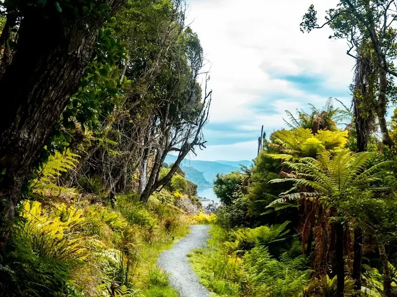
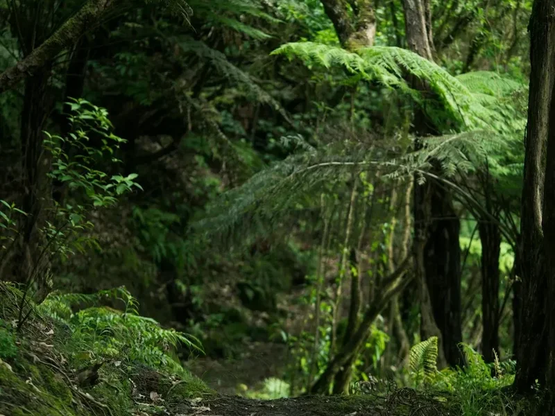
Te Araroa, meaning "The Long Pathway" in Māori, is New Zealand's national walking trail, stretching approximately 3,000 kilometres from the windswept northern tip of Cape Reinga to the rugged southern shores of Bluff. This epic thru-hike traverses a breathtaking diversity of landscapes, from subtropical forests and volcanic plateaus to rolling farmlands, alpine passes, and coastal tracks. It offers an unparalleled journey through the heart of Aotearoa, connecting vibrant cities, remote wilderness, and the rich cultural heritage of its people.
The trail is a testament to New Zealand's natural beauty and its commitment to public access. It is a challenging undertaking, typically requiring 120 to 160 days to complete, and demands significant physical and mental fortitude. Te Araroa is not merely a walk; it is an immersion into the soul of New Zealand, a chance to connect with the land, its history, and its communities in a profound and unforgettable way.
- Distance: ~3,000 km one-way
- Duration: 120–160 days
- Season: October to April (North Island can be walked earlier/later, South Island alpine sections require summer conditions)
- Accommodation: Huts, campsites, lodges, and private accommodation along the route
- Highest point: Waiau Pass, Southern Alps (~1,700 m)
- Difficulty: Challenging (requires high fitness, navigation skills, and self-sufficiency)
- Direction: Primarily North to South, but can be walked in sections or reverse
Overview
Te Araroa is a modern trail, officially opened in 2011, but its roots lie in ancient Māori pathways and the pioneering spirit of New Zealand's early settlers. The trail is meticulously designed to showcase the country's diverse environments, weaving through 20 national parks and reserves, crossing private land with landowner permission, and connecting urban centres with remote backcountry. This ambitious project is a collaborative effort between the New Zealand government, local councils, iwi (Māori tribes), and a dedicated network of volunteers.
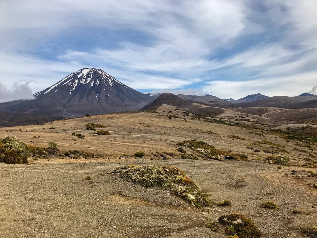
The journey begins at the iconic Cape Reinga lighthouse, where the Tasman Sea and Pacific Ocean collide. From here, the trail winds south through the North Island's unique landscapes: the dramatic Ninety Mile Beach, the geothermal wonders of Rotorua, the volcanic peaks of the Tongariro National Park, and the lush native forests of the central plateau. It then crosses Cook Strait via ferry to the South Island, where the adventure truly escalates.
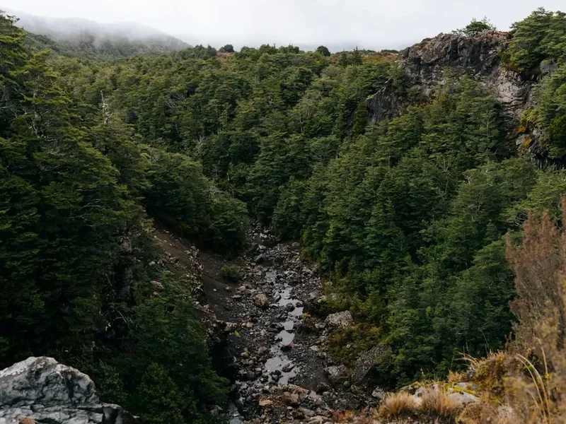
The South Island section of Te Araroa is renowned for its rugged beauty and demanding terrain. Hikers will traverse the Marlborough Sounds, ascend into the alpine wilderness of the Southern Alps, navigate glacial valleys, and follow the wild coastlines of the West Coast. Key highlights include the Queen Charlotte Track, the challenging traverse of the Tararua Range, the spectacular views from the Waiau Pass, and the final push through Fiordland National Park.
Completing Te Araroa is a significant achievement, requiring meticulous planning, unwavering determination, and a deep respect for the natural environment. It offers a unique perspective on New Zealand, revealing its wild heart and the enduring spirit of its people.
History and Cultural Context
The concept of a national walking trail in New Zealand has a long history, evolving from ancient Māori trails (pātere) that connected communities and facilitated trade and travel across the land. These routes, often following ridgelines and river valleys, were vital for survival and cultural exchange. The arrival of European settlers saw the development of roads and railways, but the desire for a dedicated long-distance walking route persisted.
The modern Te Araroa trail project began in earnest in the late 20th century, driven by a vision to create a national asset that would promote outdoor recreation, conservation, and cultural understanding. The Te Araroa Trust was established in 2005 to lead the development, construction, and ongoing management of the trail. This involved extensive consultation with landowners, iwi, local authorities, and conservation groups to secure access and ensure the trail respected the cultural and environmental significance of the land.
The trail officially opened in December 2011, marking a significant milestone in New Zealand's outdoor recreation history. Since then, thousands of hikers have embarked on the journey, experiencing the country's diverse landscapes and engaging with its unique cultural heritage. The trail's development has also fostered a deeper appreciation for conservation, highlighting the importance of protecting New Zealand's natural environments for future generations.
Te Araroa traverses lands of deep cultural significance to Māori, particularly the iwi of the regions it passes through. The trail's name itself, "The Long Pathway," reflects the historical use of these lands by Māori. The Te Araroa Trust works closely with iwi to ensure the trail respects cultural protocols, incorporates Māori narratives, and acknowledges the ancestral connection to the land. This collaborative approach is fundamental to the trail's identity and its ability to offer a holistic New Zealand experience.
Seasonal Highlights and Weather Reality
Te Araroa is a trail that can be walked year-round, but the optimal season for a thru-hike is generally from October to April. This period offers the best balance of weather conditions across both islands, though specific sections have their own ideal windows.
Spring (October–November): The North Island is generally pleasant, with blooming flora and fewer crowds. However, the South Island's alpine passes may still be snow-covered, requiring caution and potentially delaying the start of the South Island section. Water levels in rivers can be high due to snowmelt.
Summer (December–February): This is the most popular time for thru-hiking. The North Island offers warm temperatures, while the South Island's alpine passes are typically clear of snow, allowing for easier passage. However, this is also peak season for sandflies, particularly on the West Coast, and river crossings can still be challenging after heavy rain. Days are long, providing ample daylight for hiking.
Autumn (March–April): The North Island can still be warm, while the South Island offers crisp, clear days with stunning autumn colours. The risk of early snow on higher passes increases towards the end of April. Sandfly activity generally decreases. This is a good time for those seeking fewer crowds and cooler hiking temperatures.
Winter (May–September): While not ideal for a full thru-hike due to snow, ice, and shorter daylight hours, sections of the North Island can be walked. The South Island's alpine regions are generally inaccessible without advanced winter mountaineering skills and equipment. River crossings can be dangerous due to high flows and potential ice.
Weather Variability: New Zealand's weather is notoriously unpredictable. Te Araroa crosses diverse climatic zones, from subtropical north to alpine south. Hikers must be prepared for all conditions, including heavy rain, strong winds, extreme heat, and snow, even in summer. Thorough research of specific section weather patterns and constant monitoring of forecasts are crucial.
Recommended Itinerary
Te Araroa Trail - A General North to South Itinerary Outline
North Island (Approx. 1,400 km, 50-60 days)
Section 1: Cape Reinga to Northland Forests (Approx. 250 km)
- Starts at Cape Reinga Lighthouse
- Includes Ninety Mile Beach (requires careful timing with tides)
- Traverses coastal tracks and native forests
- Ends near Waipoua Forest
Section 2: Northland Forests to Auckland (Approx. 300 km)
- Continues through native bush and farmland
- Passes through towns like Dargaville and Wellsford
- Ends on the outskirts of Auckland
Section 3: Auckland to Coromandel/Bay of Plenty (Approx. 350 km)
- Crosses the Auckland isthmus
- Explores the Coromandel Peninsula's coastal beauty
- Moves inland through forests and farmland
- Ends near Tauranga
Section 4: Bay of Plenty to Rotorua/Taupō (Approx. 200 km)
- Passes through geothermal areas around Rotorua
- Includes sections of native forest and farmland
- Ends near Lake Taupō
Section 5: Taupō to Tongariro National Park (Approx. 150 km)
- Features volcanic landscapes and alpine terrain
- Includes the Tongariro Alpine Crossing (can be done as a day hike or part of the trail)
- Ends in the Ruapehu region
Section 6: Tongariro to Wellington (Approx. 150 km)
- Traverses farmland, forests, and river valleys
- Passes through towns like Taihape and Palmerston North
- Ends in Wellington, requiring a ferry crossing to the South Island
South Island (Approx. 1,600 km, 70-100 days)
Section 7: Marlborough Sounds (Approx. 250 km)
- Starts with a ferry from Wellington to Picton
- Includes the Queen Charlotte Track and other coastal routes
- Features stunning views of the Sounds
- Ends near Havelock
Section 8: Marlborough to Nelson/Tasman (Approx. 200 km)
- Moves inland through vineyards and rolling hills
- Includes sections of native bush
- Ends near Nelson
Section 9: Nelson/Tasman to West Coast (Approx. 300 km)
- Traverses the Kahurangi National Park
- Includes challenging alpine terrain and remote wilderness
- Ends on the West Coast, near the Paparoa National Park
Section 10: West Coast to Arthur's Pass (Approx. 200 km)
- Follows the rugged West Coast
- Includes sections through rainforests and along beaches
- Ascends towards Arthur's Pass National Park
Section 11: Arthur's Pass to Southern Alps (Approx. 300 km)
- The heart of the Southern Alps traverse
- Includes challenging alpine passes like Waiau Pass
- Features dramatic glacial valleys and high mountain scenery
- Ends near the Haast Pass region
Section 12: Haast Pass to Fiordland (Approx. 200 km)
- Continues through remote rainforests and coastal areas
- Enters Fiordland National Park
- Includes sections of challenging terrain and potential river crossings
Section 13: Fiordland to Bluff (Approx. 150 km)
- Traverses the southern reaches of Fiordland
- Includes coastal tracks and farmland
- Ends at Bluff, the southernmost point of the trail
Important Notes:
- This is a general outline; actual distances and timings can vary based on route choices, weather, and personal pace.
- Many sections can be hiked independently as day hikes or shorter multi-day trips.
- Accommodation varies greatly, from DOC huts and campsites to private lodges and hostels. Bookings are essential for some popular tracks (e.g., Queen Charlotte Track).
- River crossings are a significant hazard, especially after rain. Always check conditions and be prepared to wait.
- Navigation skills are essential, particularly in alpine and remote sections.
Planning and Bookings
Book Your Trip
Everything you need to plan your journey
Accommodation
Find places to stay near Wellington
Flights
Search flights to Wellington
Essential Preparation
Embarking on Te Araroa is a significant undertaking that requires extensive preparation. Fitness is paramount; hikers should be accustomed to carrying a heavy pack for extended periods over varied terrain. A typical thru-hike involves 15-25 kg of gear and food, covering 20-30 km per day for several months. Prioritize cardiovascular fitness, strength training (especially for legs and core), and endurance.
Logistics are complex. You'll need to plan resupply points, arrange transport to and from trailheads, and book accommodation where necessary. Researching each section of the trail is crucial, as conditions, access, and facilities vary dramatically. Consider the timing of your hike to align with favourable weather windows for different regions, especially the South Island's alpine passes.
The primary gateway cities for Te Araroa are Wellington (for the ferry crossing to the South Island) and Christchurch (for access to the central South Island). Auckland also serves as a major hub for the North Island start. These cities offer comprehensive services, including outdoor gear shops, supermarkets for resupply, and accommodation options.
Trail Accommodation
Te Araroa utilizes a variety of accommodation types, ranging from basic backcountry huts to comfortable lodges and private campgrounds. The availability and type of accommodation differ significantly between the North and South Islands and even between sections within each island.
Department of Conservation (DOC) Huts and Campsites: These are the most common forms of backcountry accommodation. DOC huts offer basic shelter with bunks, mattresses, and often a wood burner. Campsites are designated areas for pitching tents. Booking is required for some popular DOC tracks (e.g., Queen Charlotte Track) during peak season. Fees apply for huts and some campsites.
Private Huts and Lodges: In some areas, particularly on private land sections or near popular tourist destinations, private lodges and huts offer more comfortable amenities, often including hot showers and catered meals. These typically require advance booking and incur higher costs.
Commercial Campsites and Hostels: Towns and villages along the trail offer commercial campgrounds, backpacker hostels, and motels, providing opportunities for rest, resupply, and a break from backcountry conditions.
What's Provided: Basic shelter, bunks (bring your own sleeping bag), and often a water source (treatment recommended). Some huts have cooking facilities (gas stoves, benches), but you must bring all your own cooking equipment and fuel.
What's NOT Provided: Food, cooking equipment, bedding (sleeping bags, pillows), electricity, charging facilities, hot water (unless specified), and Wi-Fi.
Seasonal Availability: Most DOC huts and campsites are accessible year-round, but conditions can be challenging in winter. Popular tracks may have seasonal restrictions or require bookings during peak times (summer). Private accommodation operates on its own schedule.
Costs: DOC hut fees range from NZ$15 to NZ$30 per night. Campsite fees are typically NZ$10-NZ$15. Private accommodation costs vary widely, from NZ$30 for a basic bunk to NZ$200+ for a private room.
Required Gear
- Footwear: Sturdy, waterproof, well-broken-in hiking boots with good ankle support. Camp shoes or sandals for evenings.
- Backpack: 60-80 litre capacity, with a comfortable harness and hip belt. A waterproof pack liner or cover is essential.
- Shelter: A lightweight, durable tent suitable for various weather conditions.
- Sleeping System: A warm sleeping bag (rated to at least 0°C comfort) and a sleeping mat.
- Clothing:
- Moisture-wicking base layers (merino wool or synthetic)
- Insulating mid-layers (fleece or down jacket)
- Waterproof and windproof outer shell jacket and trousers (Gore-Tex or similar)
- Hiking trousers and shorts
- Warm hat and gloves
- Sun hat and sunglasses
- Navigation: Topographic maps of all sections, a compass, and a GPS device or smartphone with offline mapping capabilities (e.g., Trailforks, Maps.me). A personal locator beacon (PLB) is highly recommended.
- Safety Gear: Comprehensive first-aid kit, headlamp with spare batteries, whistle, emergency blanket, knife or multi-tool.
- Trekking Poles: Highly recommended for stability, especially on descents and river crossings.
What to Bring
- Food: Sufficient non-perishable food for each section between resupply points. Plan meals carefully to balance nutrition, weight, and taste. Dehydrated meals, pasta, rice, oats, nuts, dried fruit, and energy bars are common choices.
- Water Treatment: A reliable water filter or purification tablets. While many water sources are clear, treatment is essential to prevent illness.
- Cooking Equipment: Lightweight stove, fuel, cooking pot, mug, bowl, spoon/spork, lighter or waterproof matches.
- Toiletries: Biodegradable soap, toothbrush and toothpaste, toilet paper, hand sanitiser, sunscreen, insect repellent (especially for sandflies).
- Repair Kit: Duct tape, cordage, safety pins, needle and thread, gear repair patches.
- Personal Items: Medications, camera, book, journal, power bank for electronics.
- Documents: Identification, booking confirmations, emergency contact information.
- Cash: For small purchases in towns or where card facilities are unavailable.
Permits
While Te Araroa itself does not require a single overarching permit for the entire trail, many sections pass through areas managed by the Department of Conservation (DOC) or other authorities, which may have their own permit or booking requirements. It is crucial to research and secure these for each section you intend to hike.
Key Permit and Booking Considerations:
- DOC Hut and Campsite Bookings: For popular tracks like the Queen Charlotte Track (Marlborough Sounds) and sections within national parks, advance booking of huts and campsites is mandatory during peak season. These bookings can be made through the DOC website and often sell out well in advance.
- Private Land Access: Te Araroa crosses significant amounts of private land. While landowners have granted access, it is essential to respect their property and any specific rules they may have in place. In some cases, small fees may apply for passage through private land, or specific camping restrictions may be in effect.
- National Park Entry: Entry into most national parks in New Zealand is free. However, specific regulations regarding camping, fires, and waste disposal apply within these areas.
- Ferry Crossings: The ferry crossing between Wellington (North Island) and Picton (South Island) is a significant logistical step and requires booking with Interislander or Bluebridge.
- Tongariro Alpine Crossing: While part of Te Araroa, the Tongariro Alpine Crossing is a popular day hike that now requires a booking and fee to manage visitor numbers and protect the environment. Hikers intending to use it as part of Te Araroa must also book.
- Personal Locator Beacon (PLB): While not a permit, carrying a PLB is strongly recommended for safety in remote areas. DOC offers a hire service for PLBs.
Research is Key: The Te Araroa Trust website provides detailed information on the permit and booking requirements for each section of the trail. It is the hiker's responsibility to ensure all necessary arrangements are made before starting their journey.
Other Activities in the Area
Te Araroa offers countless opportunities to explore beyond the trail itself. Many towns and regions along the route provide excellent side trips and activities:
- North Island:
- Cape Reinga: Explore the northernmost point of New Zealand, visit the lighthouse, and witness the dramatic meeting of the oceans.
- Ninety Mile Beach: Experience the vastness of this iconic beach, known for its sandboarding and fishing.
- Rotorua: Immerse yourself in Māori culture, witness geothermal wonders (geysers, mud pools), and enjoy adventure activities like zorbing and mountain biking.
- Tongariro National Park: Hike the famous Tongariro Alpine Crossing, explore volcanic craters, and enjoy stunning alpine scenery.
- Wellington: Explore the capital city's vibrant arts scene, museums (Te Papa), and culinary delights.
- South Island:
- Marlborough Sounds: Enjoy kayaking, sailing, or boat tours through the picturesque waterways.
- Nelson Tasman: Explore the Abel Tasman National Park with its golden beaches and turquoise waters, or visit local wineries and artisan producers.
- West Coast: Visit the Punakaiki Pancake Rocks, explore glaciers (Franz Josef and Fox), and experience the rugged coastal environment.
- Arthur's Pass National Park: Hike to alpine lakes, witness dramatic mountain scenery, and spot native wildlife.
- Queenstown: The adventure capital offers bungee jumping, jet boating, skiing, and stunning lake and mountain vistas.
- Fiordland National Park: Explore Milford Sound or Doubtful Sound via boat cruise or kayaking, and marvel at the dramatic fiords and waterfalls.
Safety and Conditions
Fitness and Preparation: The most critical safety measure is adequate physical and mental preparation. Hikers must be fit enough to carry a heavy pack for months and cope with challenging terrain and weather. Thoroughly test your gear before starting.
Navigation: While Te Araroa is generally well-marked, navigation skills are essential, especially in remote sections, alpine areas, and during poor visibility. Carry and know how to use maps, a compass, and a GPS device. Always inform someone of your intended route and expected return time.
River Crossings: River crossings are a significant hazard on Te Araroa, particularly after rain. Rivers can rise rapidly, becoming dangerous or impassable. Always assess the conditions carefully, check local weather forecasts, and be prepared to wait for water levels to drop. Never attempt to cross a fast-flowing or deep river. Use trekking poles for stability.
Weather: New Zealand's weather is highly variable and can change rapidly, especially in alpine and coastal areas. Be prepared for all conditions, including strong winds, heavy rain, extreme heat, and snow. Hypothermia is a risk even in summer at higher altitudes. Carry appropriate layers and waterproof gear.
Sandflies: These biting insects are prevalent, especially on the West Coast and in damp, forested areas during warmer months. Use effective insect repellent (DEET-based), wear long sleeves and trousers, and consider a head net.
Wildlife: While New Zealand has few dangerous animals, be aware of your surroundings. Kea (alpine parrots) can be curious and may damage gear. Respect all wildlife and maintain a safe distance.
Communication: Mobile phone coverage is intermittent and often non-existent in remote areas. A Personal Locator Beacon (PLB) or satellite messenger is highly recommended for emergencies.
Health: Carry a comprehensive first-aid kit and know how to use it. Be aware of potential health issues such as blisters, dehydration, and exhaustion. Plan your resupply points carefully to ensure you have adequate food and medication.
Trail Alerts: Regularly check the Te Araroa Trust website and DOC alerts for any track closures, hazards, or changes in conditions. This is crucial for staying informed about potential dangers.
Side Trips and Points of Interest
Te Araroa is a journey through some of New Zealand's most spectacular landscapes, offering numerous opportunities for side trips and exploration:
North Island:
- Waipoua Forest (Northland): Home to Tāne Mahuta, the largest living kauri tree in New Zealand, and Te Matua Ngahere, the second largest. These ancient giants are of immense cultural and ecological significance.
- Cathedral Cove (Coromandel Peninsula): A stunning sea arch and beach accessible via a coastal walk, famous for its natural beauty.
- Hot Water Beach (Coromandel Peninsula): Dig your own hot pool in the sand during low tide.
- Mount Tarawera (Rotorua): Hike to the crater rim of this active volcano for panoramic views of the surrounding lakes and geothermal areas.
- Tongariro Alpine Crossing: While part of the trail, many hikers opt to do this as a dedicated day trip, experiencing the dramatic volcanic landscapes, emerald lakes, and steaming vents.
South Island:
- Queen Charlotte Track (Marlborough Sounds): A world-renowned track offering stunning coastal views, pristine beaches, and abundant birdlife.
- Abel Tasman National Park: Explore golden beaches, turquoise waters, and lush coastal forests via water taxi, kayak, or walking sections of the Abel Tasman Coast Track.
- Punakaiki Pancake Rocks and Blowholes (West Coast): Witness the unique geological formations and powerful blowholes.
- Franz Josef and Fox Glaciers (West Coast): Take a guided heli-hike or scenic flight to explore these accessible glaciers.
- Arthur's Pass National Park: Numerous day hikes offer access to alpine lakes, dramatic peaks, and diverse flora and fauna.
- Mount Cook National Park: While not directly on Te Araroa, a detour to Aoraki/Mount Cook offers incredible alpine scenery, glacier walks, and the opportunity to see New Zealand's highest peak.
- Milford Sound / Doubtful Sound (Fiordland): Iconic fiords offering breathtaking scenery, waterfalls, and wildlife viewing opportunities via boat cruises or kayaking.
Leave No Trace
Te Araroa traverses some of New Zealand's most pristine and ecologically sensitive environments. Adhering to Leave No Trace principles is not just a guideline; it is a fundamental responsibility for all hikers to protect these landscapes for future generations.
Plan Ahead and Prepare: Research your route, understand the terrain, weather, and any specific regulations for the areas you will be visiting. Pack appropriately and be prepared for all conditions.
Travel and Camp on Durable Surfaces: Stick to marked trails to avoid damaging fragile vegetation. Use designated campsites or durable surfaces for camping. Avoid trampling sensitive alpine plants or creating new paths.
Dispose of Waste Properly: Pack out everything you pack in, including all food scraps, wrappers, and toilet paper. Use designated toilets where available. If no toilet facilities exist, dig a cathole at least 70 metres away from water sources, trails, and campsites.
Leave What You Find: Do not remove or disturb natural objects, plants, or cultural artifacts. Take only photographs and memories.
Minimize Campfire Impacts: Campfires are often prohibited in national parks and sensitive areas. If permitted, use existing fire rings and keep fires small. Ensure fires are completely extinguished before leaving.
Respect Wildlife: Observe wildlife from a distance. Never feed animals, as this can disrupt their natural behaviours and diets. Store food securely to prevent attracting pests.
Be Considerate of Other Visitors: Respect the solitude and experience of others. Keep noise levels down, yield to other hikers, and be courteous on the trail.
By practicing these principles, you contribute to the preservation of Te Araroa's natural and cultural heritage, ensuring its beauty and accessibility for years to come.