
Tatra High Route - The Crown of the Carpathians
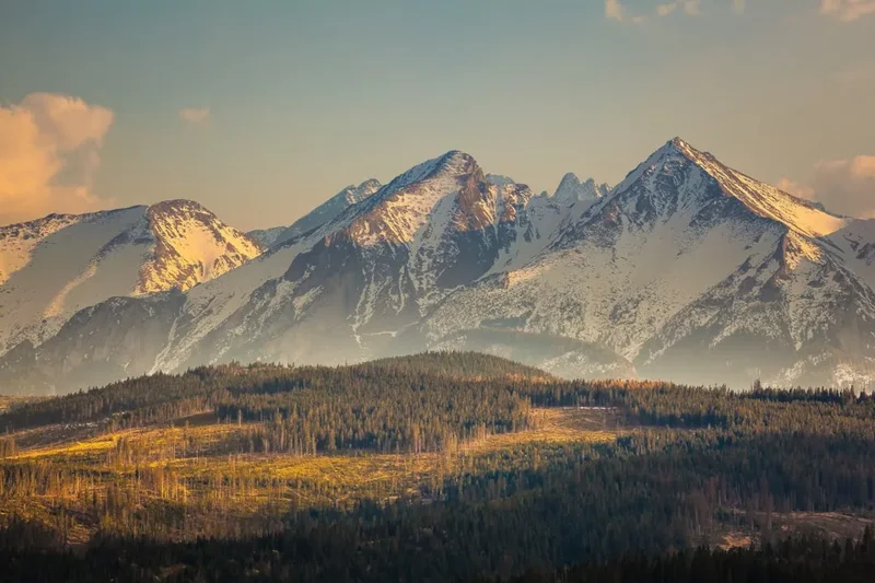
The Tatra High Route is the definitive alpine traverse of the High Tatras, the loftiest range within the Carpathian Mountains. Spanning approximately 70 kilometres and crossing the international border between Poland and Slovakia, this route offers a concentrated dose of high-altitude drama, technical challenge, and breathtaking glacial scenery. Known locally as the Tatranská magistrála on the Slovak side and incorporating the rugged approaches from Zakopane in Poland, the journey takes trekkers through a landscape of jagged granite peaks, deep emerald-green tarns (plesá), and narrow mountain passes that demand both physical stamina and a steady head for heights. With a total elevation gain of 5,000 metres, this is not a casual stroll; it is a serious mountain undertaking that rewards the adventurous with some of the most spectacular alpine vistas in Central Europe.
- Distance: 70.0 km (approximate traverse)
- Duration: 6–8 days
- Season: July to September (high-altitude passes are snow-bound and closed to hikers from November to mid-June)
- Accommodation: Mountain huts (Chata/Schronisko) - mandatory booking recommended
- Highest point: Rysy (2,503 m) - the highest peak in Poland and a key crossing point
- Difficulty: Very Challenging (includes steep ascents, exposed ridges, and sections with fixed chains)
- Direction: Typically walked West to East, starting in Zakopane (Poland) and ending in Tatranská Kotlina (Slovakia)
Overview
The Tatra Mountains may be the smallest "high" mountain range in the world, but what they lack in footprint, they more than make up for in verticality and ruggedness. The Tatra High Route is a masterclass in alpine topography, carved by ancient glaciers into a series of sharp ridges and deep, U-shaped valleys. The route is characterised by its "staircase" nature—long, grueling climbs to high mountain passes followed by steep descents into pristine valleys where mountain huts provide a warm refuge. Unlike the rolling hills of the Beskids or the Bieszczady, the High Tatras are composed of hard granite, resulting in a landscape that feels more akin to the Swiss Alps than the surrounding Central European plains.
The experience of walking the Tatra High Route is defined by its transitions. You begin in the lush, pine-scented forests of the lower valleys, where the air is thick with the sound of rushing streams. As you ascend, the forest gives way to the dwarf pine zone (kosodrevina), and eventually to the high alpine meadows where the rare Tatra chamois and marmots can often be spotted. The final tier is the world of rock and sky—vast boulder fields, narrow ledges, and the iconic granite spires that have challenged mountaineers for centuries. The weather here is a powerful protagonist; the range acts as a barrier to weather systems moving across Europe, meaning that clear blue skies can transform into dramatic thunderstorms with startling speed.
Culturally, the route is just as rich. The Tatras are the spiritual home of Polish and Slovak mountaineering. The mountain huts along the way are not merely places to sleep; they are historic institutions, some dating back over a century, where the "Goral" (highlander) culture is still palpable in the architecture, the food, and the hospitality. Whether you are navigating the exposed chains of the Polish High Tatras or traversing the long, scenic balconies of the Slovak Magistrála, the Tatra High Route offers a profound sense of connection to a landscape that is both fiercely protected and deeply loved by the two nations that share it.
History and Cultural Context
The history of the Tatra High Route is inextricably linked to the birth of alpine tourism in Central Europe. For centuries, the high valleys were the domain of shepherds, herbalists, and miners seeking gold and copper. However, the late 19th century saw a surge in interest from scientists and explorers, led by figures such as Tytus Chałubiński in Poland, who promoted the Tatras for their health benefits and majestic beauty. The first mountain huts were established during this era, and the "Magistrála" concept—a continuous high-level trail—was formalised in the 1930s to connect these remote outposts.
The cultural significance of the Tatras cannot be overstated. For Poles, Zakopane became the "winter capital" and a sanctuary for artists and intellectuals during the partitions of Poland. The unique Zakopane style of architecture, with its intricate wood carvings and steep roofs, was inspired by the traditional dwellings of the Goral people. On the Slovak side, the mountains are a symbol of national identity, featured on the national coat of arms and celebrated in countless folk songs. The establishment of the Tatra National Park (TANAP) in Slovakia in 1949 and the Tatrzański Park Narodowy (TPN) in Poland in 1954 marked a turning point in the conservation of this fragile ecosystem, ensuring that the "Crown of the Carpathians" remained wild.
Today, the route serves as a bridge between two nations. The 1990s saw the removal of strict border controls, allowing hikers to cross freely between Poland and Slovakia at designated points like the summit of Rysy. This freedom of movement has transformed the Tatra High Route into a truly international adventure, where one can enjoy a Polish "bigos" (hunter's stew) for lunch and a Slovak "kapustnica" (cabbage soup) for dinner, all while traversing the same geological spine.
Want more background? Read extended notes on history and cultural context → Learn more
Seasonal Highlights and Weather Reality
The window for completing the full Tatra High Route is relatively narrow. Due to the high altitude and the technical nature of the passes, the route is only fully accessible during the summer and early autumn months. In Slovakia, high-altitude trails are legally closed from 1 November to 14 June to protect the environment and ensure hiker safety, making the summer season a busy but vibrant time.
Summer (July and August): This is the peak season. The weather is generally at its warmest, and the alpine flora is in full bloom. However, this is also the season of the "Tatra storms." Afternoon thunderstorms are common and can be extremely dangerous on exposed ridges. Hikers are advised to start their days at dawn to ensure they are off the high passes by early afternoon. This is also the busiest time, and huts must be booked months in advance.
Autumn (September to early October): Many experienced hikers consider September the best month for the Tatra High Route. The summer crowds dissipate, the air becomes crisper and clearer (offering the best visibility for photography), and the dwarf pines and grasses turn a beautiful golden hue. While the days are shorter and the nights are colder, the weather is often more stable than in mid-summer. However, early snowfalls can occur as early as late September, potentially making passes like Rysy or Zawrat treacherous.
Winter and Spring (November to June): During this period, the High Tatras become the domain of ski mountaineers and experienced winter climbers. The High Route as described is not suitable for standard trekking. Avalanches are a significant and frequent hazard, and the technical sections require ice axes, crampons, and high-level winter navigation skills. Most high-altitude huts remain open but operate with limited services, and the trails are often buried under several metres of snow.
Recommended Itinerary

7-Day Tatra High Route Traverse
Day 1: Zakopane (Kuźnice) to Murowaniec Hut
- Distance: 7 km
- Elevation gain: 600 m
- Time: 3–4 hours
- Start at Kuźnice, the gateway to the Polish Tatras
- Ascend through the Jaworzynka Valley or via Skupniów Upłaz for expansive views of the Podhale region
- Arrive at Schronisko Murowaniec in the Gąsienicowa Valley
- Explore the nearby Czarny Staw Gąsienicowy, a stunning black glacial lake beneath the towering walls of Kościelec
- This day serves as an essential warm-up and acclimatisation period
Day 2: Murowaniec to Five Polish Lakes Valley (Dolina Pięciu Stawów)
- Distance: 8 km
- Elevation gain: 750 m
- Time: 5–6 hours
- A challenging day crossing the Zawrat Pass (2,158 m)
- The ascent to Zawrat involves steep sections with fixed chains—a head for heights is required
- Descend into the spectacular Valley of the Five Polish Lakes, often cited as the most beautiful valley in Poland
- Stay at Schronisko w Dolinie Pięciu Stawów Polskich, the highest hut in Poland
- Views of the Wielka Siklawa waterfall, the largest in the Tatras
Day 3: Five Lakes Valley to Popradské Pleso (Slovakia) via Rysy
- Distance: 12 km
- Elevation gain: 1,100 m
- Time: 8–9 hours
- The "Queen Stage" of the route, crossing the international border
- Descend to Morskie Oko, the most famous lake in the Tatras, then begin the long ascent of Rysy (2,503 m)
- The Polish side of Rysy is very steep with extensive chain sections
- Summit Rysy for a 360-degree view of the entire range
- Descend the easier Slovak side, passing Chata pod Rysmi (the highest hut in the Tatras)
- Finish at the picturesque Popradské Pleso
Day 4: Popradské Pleso to Sliezsky dom
- Distance: 11 km
- Elevation gain: 600 m
- Time: 4–5 hours
- Join the Tatranská magistrála, the red-marked traverse trail
- Ascend to Ostrva (1,984 m) via a series of steep switchbacks for a bird's-eye view of the Mengusovská Valley
- Follow the high-level balcony trail with constant views of the Slovak plains to the south
- Pass Batizovské pleso, reflecting the massive wall of Gerlachovský štít (the highest peak in the Carpathians)
- Arrive at Sliezsky dom, a modern mountain hotel located at the base of Gerlach
Day 5: Sliezsky dom to Zamkovského chata
- Distance: 10 km
- Elevation gain: 300 m
- Time: 4 hours
- A relatively gentler day following the contour of the mountains
- Pass through the Hrebienok area, a popular tourist hub
- Visit the Cold Water Waterfalls (Vodopády Studeného potoka), a series of powerful cascades
- Ascend slightly to Zamkovského chata, nestled in the forest at the mouth of the Malá Studená Valley
- This hut is famous for its cosy atmosphere and traditional herbal teas
Day 6: Zamkovského chata to Chata pri Zelenom plese
- Distance: 9 km
- Elevation gain: 700 m
- Time: 5–6 hours
- Ascend to the Skalnaté pleso, located beneath the dramatic Lomnický štít
- Cross the Veľká Svišťovka pass (2,023 m), the final high pass of the route
- The descent to Zelené pleso (Green Lake) is steep and involves some chain-assisted sections
- Arrive at Chata pri Zelenom plese, arguably the most spectacularly situated hut in the range, surrounded by vertical granite walls
Day 7: Chata pri Zelenom plese to Tatranská Kotlina
- Distance: 13 km
- Elevation gain: 200 m (mostly descent)
- Time: 4–5 hours
- Walk through the Belianske Tatras, a limestone range with different flora and softer landscapes
- Pass the Veľké Biele pleso (Great White Lake)
- Long descent through the forest to the village of Tatranská Kotlina
- Optional visit to the Belianska Cave, the only cave in the Tatras open to the public
- End of the traverse; take a bus back to Poprad or Zakopane
Important Notes:
- The itinerary involves technical sections (chains). If weather is poor, these sections become dangerous.
- Mountain huts must be booked well in advance, especially for weekends.
- The crossing of Rysy is physically demanding; ensure you have sufficient water and energy.
- Always check the weather forecast from HZS (Slovakia) or TOPR (Poland) before setting out.
Planning and Bookings
Book Your Trip
Everything you need to plan your journey
Accommodation
Find places to stay near Zakopane
Flights
Search flights to Zakopane
Essential Preparation
The Tatra High Route requires a high level of physical fitness and careful logistical planning. Because the route crosses an international border and stays at high altitudes, you must coordinate your transport, accommodation, and insurance. The base town for the Polish side is Zakopane, which is easily reached from Krakow by bus or train (approx. 2–3 hours). On the Slovak side, the town of Poprad serves as the main transport hub, connected to the mountain villages by the "Tatra Electric Railway."
Before departing, you should familiarise yourself with the trail markings. In the Tatras, trails are marked by colour (Red, Blue, Green, Yellow, Black). The colour does not indicate difficulty, but rather the type of trail (Red is usually the main traverse or long-distance route). You will need a high-quality topographical map (1:25,000 scale) covering both the Polish and Slovak sides of the High Tatras.
Trail Accommodation
Accommodation on the Tatra High Route is provided by a network of mountain huts, known as "Schronisko" in Poland and "Chata" in Slovakia. These huts are an integral part of the experience, offering a unique alpine atmosphere.
Hut Facilities:
- Dormitory-style bunk beds (pillows and blankets usually provided, but a silk liner is recommended)
- Dining rooms serving hot meals (soups, stews, dumplings, and local beer)
- Common washrooms with toilets and (usually) hot showers (showers may require a fee or tokens)
- Drying rooms for wet gear
- Charging stations for phones (though these can be crowded)
- Emergency floor space (in Poland, huts are legally required to provide floor space if you arrive after dark, though this is not the case in Slovakia)
What Huts Don't Provide:
- Towels and toiletries
- Free WiFi (some have it, but it is often unreliable)
- Private rooms (some huts have them, but they sell out instantly)
- Quiet—huts are social and can be noisy until the 10:00 PM "silent hours"
Booking Requirements:
- Bookings for peak summer (July–August) should be made 3–6 months in advance.
- Most huts have online booking systems or can be contacted via email.
- Costs range from €20 to €45 per night for a dormitory bed, depending on the hut and the country.
- Sliezsky dom is a higher-end mountain hotel and is significantly more expensive than the traditional huts.
Required Gear
- Technical hiking boots - Must have stiff soles and excellent grip for granite and wet rock. Ankle support is essential.
- Waterproof jacket and trousers - High-quality hardshell (Gore-Tex or similar) is mandatory. The Tatras are famous for sudden, heavy downpours.
- Backpack - 35–45 litres is usually sufficient for a hut-to-hut trip. Ensure it has a rain cover.
- Trekking poles - Highly recommended for the steep descents to save your knees.
- Navigation - Physical map (1:25,000) and a compass. A GPS app with offline maps (like Mapy.cz) is excellent but should not be your only source.
- Head torch - Essential for early starts and navigating huts at night.
- First aid kit - Include blister plasters (Compeed), antiseptic wipes, and any personal medication.
- Sun protection - High-altitude sun is intense. Bring SPF 50+, sunglasses (Category 3 or 4), and a hat.
What to Bring
- Water - At least 2 litres of carrying capacity. While there are streams, they may be contaminated by livestock or heavy hiker traffic in lower areas; treatment is advised.
- High-energy snacks - Nuts, chocolate, energy bars, and dried fruit for the long climbs.
- Cash - Many huts in the Tatras (especially on the Slovak side) prefer cash (Euros) for meals and drinks. Polish huts take Złoty.
- Silk sleeping bag liner - For hygiene in hut dormitories.
- Lightweight towel - Microfibre towels save space and dry quickly.
- Earplugs - Essential for sleeping in crowded dormitories.
- Warm layers - Even in summer, temperatures at 2,000 metres can drop to near freezing. Bring a fleece and a lightweight down jacket.
- Personal ID/Passport - You are crossing an international border. While there are no checkpoints, you must carry valid identification.
Permits
The Tatra High Route passes through two national parks: Tatrzański Park Narodowy (TPN) in Poland and Tatranský národný park (TANAP) in Slovakia. Both parks have specific regulations and fees that hikers must adhere to.
Entry Fees:
- Poland (TPN): There is a daily entry fee to enter the park from Zakopane. As of 2024, this is approximately 10 PLN (approx. €2.30) per day. You can purchase multi-day passes at the entry gates or online via the TPN website to avoid queues.
- Slovakia (TANAP): Currently, there is no general entry fee for hikers entering the Slovak Tatra National Park, though this is subject to change. However, parking at trailheads usually incurs a fee.
Regulations:
- No Wild Camping: Camping is strictly prohibited in both national parks. You must stay in designated mountain huts. Fines for wild camping are heavy and strictly enforced by park rangers.
- Trail Closures: In Slovakia, all trails above the mountain huts are closed from 1 November to 14 June. Walking on these trails during the closure period can result in a significant fine.
- Stay on Trails: You must remain on marked trails at all times to protect the fragile alpine flora and prevent erosion.
- Dogs: Dogs are generally prohibited on trails in the Slovak High Tatras. In Poland, they are allowed only on certain lower-level paths (e.g., Droga pod Reglami) and are not permitted on the High Route.
Mountain Rescue Insurance: This is the most critical "permit" you need. In Slovakia, mountain rescue services (HZS) are NOT free. If you require assistance and do not have specific mountain rescue insurance, you will be billed thousands of Euros. Ensure your travel insurance specifically covers "mountain hiking up to 2,500m" and "search and rescue." In Poland, rescue (TOPR) is currently free, but insurance is still highly recommended for medical costs.
Other Activities in the Area
The regions surrounding the Tatras offer a wealth of activities for those looking to rest their legs or extend their stay:
- Thermal Baths: After a week of hiking, soak your muscles in the region's famous thermal waters. In Poland, Terma Bania or Termy Chochołowskie are popular. In Slovakia, AquaCity Poprad or the thermal park in Vrbov offer excellent facilities.
- Zakopane Culture: Explore the wooden architecture of Zakopane, visit the Tatra Museum, and walk down Krupówki Street for local crafts and "oscypek" (smoked sheep's cheese).
- Lomnický štít Cable Car: For those who want the view without the climb, a spectacular cable car runs from Tatranská Lomnica to the summit of Lomnický štít (2,634 m), the second-highest peak in the range.
- Belianska Cave: Located near the end of the route in Tatranská Kotlina, this is a stunning limestone cave with impressive stalactite formations.
- Spiš Castle: A UNESCO World Heritage site located about an hour's drive from Poprad. It is one of the largest castle complexes in Central Europe.
- Rafting on the Dunajec: Experience a traditional wooden raft trip through the Pieniny Gorge, located just north of the Tatras on the border.
Safety and Conditions
Weather Awareness: The Tatras are notorious for rapid weather changes. A sunny morning can turn into a violent thunderstorm by 2:00 PM. Lightning is a lethal threat on the exposed ridges and chain sections of the High Route. If you hear thunder or see dark clouds gathering, descend immediately. Do not wait for the rain to start. In the event of a storm, avoid standing near metal chains or ladders.
Technical Terrain: Sections of the route, particularly the Zawrat Pass and the Polish side of Rysy, involve fixed chains, ladders, and iron steps. These are not "climbing" routes in the technical sense, but they require a high degree of sure-footedness and a lack of vertigo. If the rock is wet or icy, these sections become significantly more dangerous. If you are uncomfortable with exposure, consider hiring a mountain guide for these stages.
Wildlife: The Tatras are home to brown bears. While encounters on the high-altitude trails are rare, they do occur, especially in the forested zones. Never leave food or rubbish outside huts, and if you encounter a bear, do not run; speak calmly and back away slowly. The Tatra chamois is a more common sight; please keep your distance to avoid stressing these protected animals.
Emergency Contacts:
- Slovakia (HZS): Call 18 300 or the international emergency number 112. The HZS app is highly recommended for real-time location tracking during an emergency.
- Poland (TOPR): Call 985 or +48 601 100 300.
Hydration and Nutrition: The physical exertion of gaining 1,000 metres of elevation in a day is significant. Carry electrolyte powder and ensure you are eating enough calories. Dehydration and exhaustion are the leading causes of accidents in the Tatras.
Side Trips and Points of Interest
Gerlachovský štít (2,655 m): The highest peak in the entire Carpathian range. It is not accessible via a marked hiking trail. To stand on the summit, you must hire a certified UIAGM mountain guide. The ascent is a classic alpine scramble and is a popular "extra" for those staying at Sliezsky dom.
Kasprowy Wierch: A prominent peak on the border between Poland and Slovakia. It is accessible by cable car from Zakopane and offers a fantastic ridge walk that can be integrated into the first day of the route for those wanting more views and less forest walking.
The Orla Perć (Eagle's Path): Known as the most difficult and dangerous marked trail in the Tatras. It branches off from the Zawrat Pass. It is a long, extremely exposed ridge walk with constant chains and ladders. It is only recommended for very experienced hikers with no fear of heights and should never be attempted in poor weather.
Morskie Oko and Czarny Staw pod Rysami: While the High Route passes these lakes, taking the time to walk the full circumference of Morskie Oko (Eye of the Sea) allows you to appreciate the scale of the Mięguszowiecki peaks reflecting in the water. The climb from Morskie Oko to the higher Czarny Staw (Black Pond) offers one of the most iconic views in Poland.
Symbolic Cemetery at Popradské Pleso: A moving memorial dedicated to those who have lost their lives in the Tatra Mountains. It is located in a pine grove near the lake and features colourful hand-carved wooden crosses and plaques. It is a sobering reminder of the power of the mountains.
Leave No Trace
The Tatra Mountains are a small, high-pressure environment. With millions of visitors each year, the impact on the ecosystem is significant. As a hiker on the High Route, you have a responsibility to minimise your footprint and preserve this wilderness.
Leave No Trace Principles in the Tatras:
- Pack it in, pack it out: There are no rubbish bins on the trails or at the high-altitude huts. You must carry all your waste (including fruit peels and tissues) back down to the valleys.
- Respect the water: The glacial tarns (plesá) are extremely fragile ecosystems. Swimming is strictly prohibited in all mountain lakes in both national parks. Even the chemicals in sunscreen can harm the rare aquatic life.
- Do not feed the wildlife: Feeding marmots or foxes makes them dependent on humans and can lead to aggressive behaviour or disease.
- Keep it quiet: The Tatras are a sanctuary. Avoid shouting or playing music on speakers. Let the sounds of nature prevail.
- Use the toilets: Use the facilities at the mountain huts. If you are caught between huts, ensure you are at least 50 metres from water sources and bury waste deeply. Carry out your toilet paper.
- No shortcuts: Cutting switchbacks causes severe erosion and destroys alpine vegetation that takes years to grow in the harsh climate.
Useful Links
- HZS - Slovak Mountain Rescue Service (Weather & Alerts)
- TOPR - Polish Mountain Rescue Service
- TPN - Polish Tatra National Park (Official Site)
- TANAP - Slovak Tatra National Park (Official Site)
- Mapy.cz - Excellent Offline Hiking Maps
- SHMÚ - Slovak Hydrometeorological Institute
- Polish Tatra Huts Booking Portal