Tadiandamol Trek - Coorg's Majestic Peak
The Tadiandamol Trek is a captivating day hike located in the verdant hills of Kodagu (Coorg) district in Karnataka, India. Standing as the highest peak in the district, Tadiandamol offers a rewarding ascent through diverse landscapes, from lush shola forests to open grasslands, culminating in breathtaking panoramic views from its summit. This trek is a popular choice for nature enthusiasts, trekkers, and photographers seeking a moderate challenge and a profound connection with the Western Ghats' natural beauty. The journey to the peak is an immersion into the rich biodiversity of the region, with opportunities to spot various flora and fauna. While primarily a day hike, the experience is often extended by exploring the surrounding areas, making it a comprehensive outdoor adventure.
- Distance: 13.0 km (round trip)
- Duration: 5-6 hours (trekking time)
- Season: September to May (post-monsoon to pre-summer)
- Elevation Gain: 1150 m
- Difficulty: Moderate
- Base Town: Kakkabe
- Trailhead: Nalknad Palace
- Highest Point: Tadiandamol Peak (1748 m)
- Permits: Generally not required, but check local regulations
Overview
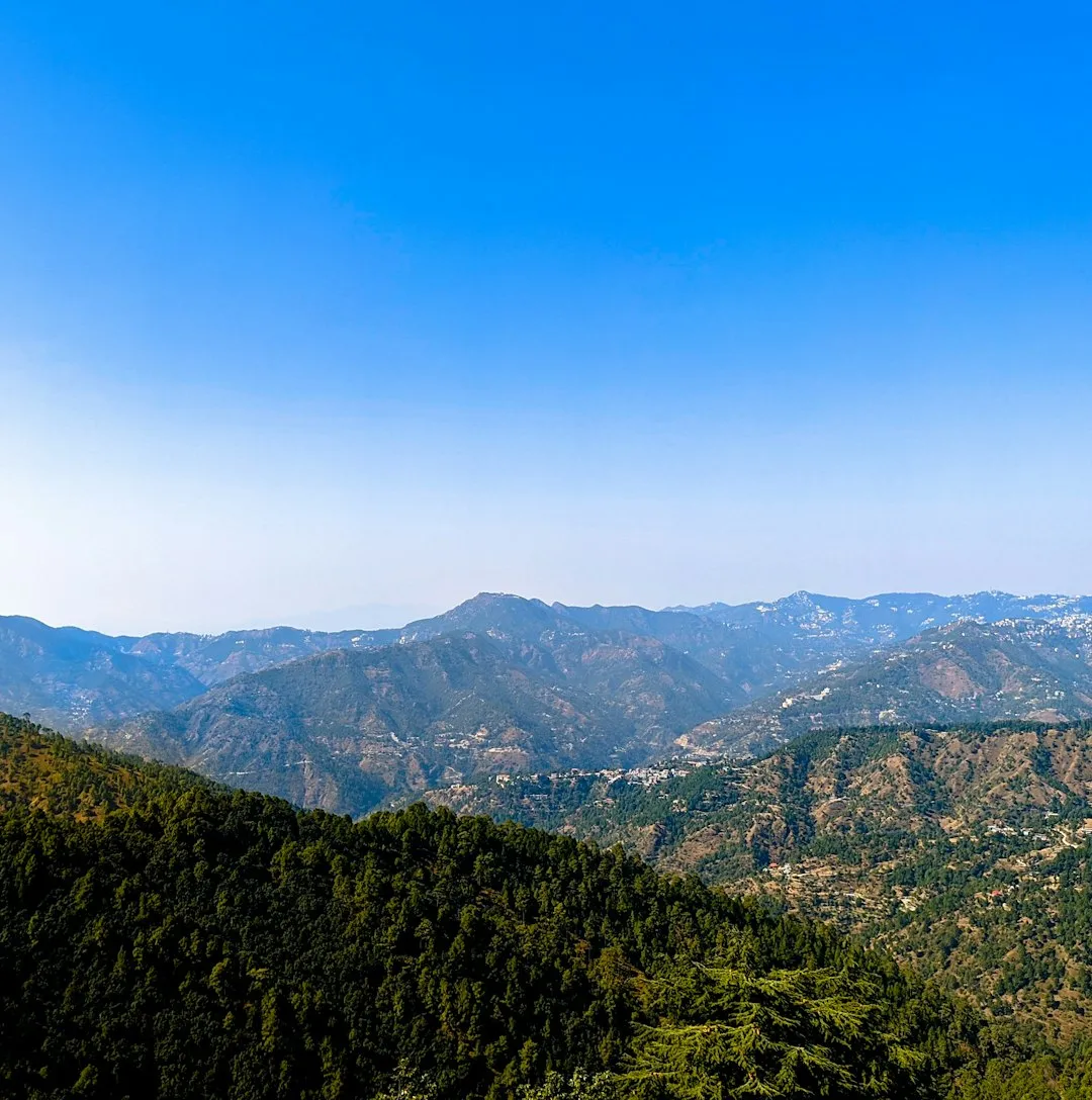
Tadiandamol, meaning "large mountain" in the local dialect, is a prominent peak in the Brahmagiri Range, offering a quintessential Coorg trekking experience. The trail begins near the historic Nalknad Palace and gradually ascends through a mosaic of landscapes. Initially, trekkers navigate through dense shola forests, characterised by stunted trees and thick undergrowth, providing a cool and shaded environment. As the altitude increases, the forest gives way to expansive grasslands, offering wider vistas and a sense of openness. The final ascent to the summit is a steady climb across these rolling meadows, often dotted with wildflowers during the post-monsoon season.
The summit of Tadiandamol, at 1748 metres, provides a spectacular 360-degree view of the surrounding Western Ghats. On clear days, one can see the mist-covered hills stretching as far as the eye can see, the valleys below dotted with coffee plantations and paddy fields, and the distant plains. The descent offers a different perspective, allowing trekkers to appreciate the scale and beauty of the terrain they have conquered. The trek is well-suited for individuals and groups looking for a day-long adventure that combines physical exertion with immense natural beauty. The moderate difficulty level makes it accessible to most fitness levels, provided they are prepared for the elevation gain.
The best time to undertake this trek is after the monsoon season, from September to May. During this period, the weather is generally pleasant, the skies are clearer, and the landscape is lush and green. The post-monsoon months (September to November) are particularly beautiful, with the residual rains having revitalised the vegetation and the air being fresh and clean. The pre-summer months (March to May) offer warmer weather, but the views remain stunning. The monsoon season itself (June to August) is generally avoided due to heavy rainfall, slippery trails, and reduced visibility, although it offers a dramatically different, albeit challenging, experience for seasoned trekkers.
History and Cultural Context
The Tadiandamol region, like much of Coorg, has a rich history intertwined with the local Kodava people and their traditions. The peak itself, being the highest point in the district, has likely held cultural and spiritual significance for centuries. The Nalknad Palace, located near the trailhead, adds a historical dimension to the trek. Built in the 18th century by the Haleri dynasty, it served as a fort and a summer retreat. It was also the site where the last ruler of Coorg, Chikka Virarajendra, surrendered to the British in 1834, marking the end of Kodagu's independent rule.
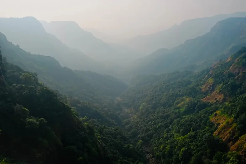
The Brahmagiri Range, of which Tadiandamol is a part, is known for its biodiversity and has been a source of natural resources for the local communities for generations. The shola forests and grasslands have supported unique ecosystems, and the streams originating from these hills are vital water sources for the surrounding villages and agricultural lands, particularly the famous Coorg coffee plantations. The trek route itself is a well-trodden path, used by locals for generations, though it has gained popularity as a trekking destination in recent decades.
The cultural landscape of Coorg is deeply connected to its natural environment. The Kodava people have a strong reverence for nature, and their festivals and traditions often reflect this connection. While Tadiandamol is not associated with specific major religious festivals, its prominence as a natural landmark means it is part of the collective consciousness and geographical identity of the region. The trek offers a glimpse into this harmonious relationship between people and nature that characterises the Coorg district.
Seasonal Highlights and Weather Reality
The Tadiandamol trek is best enjoyed during specific times of the year, each offering a distinct experience shaped by the prevailing weather and landscape conditions.
Post-Monsoon (September to November): This is arguably the most popular and rewarding season. The heavy monsoon rains have subsided, leaving the landscape incredibly lush and green. Waterfalls are at their most impressive, and the air is fresh and clean. Wildflowers often bloom during this period, adding vibrant colours to the grasslands. The weather is generally pleasant, with moderate temperatures and clear skies, offering excellent visibility from the summit. However, some patches of the trail might still be damp or muddy.
Winter (December to February): The winter months are characterised by cool to cold temperatures, especially in the mornings and evenings. Daytime temperatures are pleasant, making it ideal for trekking. The skies are typically clear, providing excellent panoramic views. This season is also less crowded than the immediate post-monsoon period. However, the landscape might appear less vibrant compared to the post-monsoon months, with grasslands turning golden-brown.
Pre-Summer (March to May): As summer approaches, temperatures begin to rise. While the days can become warm, the mornings and evenings remain relatively cool. The skies are generally clear, offering good views. This period is suitable for trekking, but it's advisable to start early in the morning to avoid the midday heat. The vegetation might start to look drier compared to the post-monsoon season.
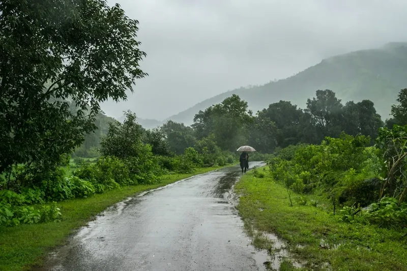
Monsoon (June to August): This season is generally not recommended for trekking Tadiandamol due to heavy rainfall, leeches, slippery trails, and poor visibility. The shola forests can become dense and challenging to navigate, and the risk of landslides, though low, is present. However, for experienced trekkers seeking a raw, challenging, and intensely green experience, the monsoon can offer a unique perspective, with the landscape coming alive with water and mist. It is crucial to check local conditions and exercise extreme caution if attempting the trek during this period.
Recommended Itinerary
Tadiandamol Day Trek Itinerary
Early Morning (6:00 AM - 7:00 AM): Arrival at Trailhead
- Reach Nalknad Palace, the designated starting point for the Tadiandamol trek.
- Brief acclimatisation and preparation.
- Engage with local guides if hired.
- Final checks of water and snacks.
Morning (7:00 AM - 10:00 AM): Ascent through Shola Forests
- Begin the trek from Nalknad Palace.
- The initial part of the trail winds through dense shola forests.
- Experience the cool, shaded environment and the sounds of the forest.
- Observe diverse flora, including various species of trees, ferns, and mosses.
- The path is relatively well-defined but can be uneven.
Late Morning (10:00 AM - 12:00 PM): Transition to Grasslands
- The forest cover gradually thins out, giving way to open grasslands.
- The gradient becomes steeper as you gain altitude.
- Enjoy the first expansive views of the surrounding valleys and hills.
- This section offers a good opportunity for short breaks and hydration.
Midday (12:00 PM - 1:30 PM): Summit Push and Exploration
- The final ascent to Tadiandamol peak.
- The terrain is primarily open grassland with a steady incline.
- Reach the summit (1748 m).
- Spend time at the peak, soaking in the 360-degree panoramic views.
- Enjoy packed lunch and capture photographs.
- Observe the unique rock formations at the summit.
Afternoon (1:30 PM - 4:30 PM): Descent and Return to Trailhead
- Begin the descent, retracing your steps.
- The descent can be quicker but requires careful footing, especially on steeper sections.
- Pass through grasslands and then back into the shola forest.
- Arrive back at Nalknad Palace.
Late Afternoon (4:30 PM onwards): Departure
- Refresh and relax at the trailhead.
- Option to visit Nalknad Palace if time permits.
- Depart from the Tadiandamol trailhead.
Important Notes:
- This is a day hike; no overnight accommodation is required on the trail.
- Carry sufficient water and snacks for the entire duration.
- Start early to avoid the midday sun and allow ample time for the descent.
- Wear appropriate trekking shoes with good grip.
- Be prepared for changing weather conditions.
- Respect the natural environment and follow Leave No Trace principles.
Planning and Bookings
Book Your Trip
Everything you need to plan your journey
Accommodation
Find places to stay near Madikeri
Flights
Search flights to Madikeri
Essential Preparation
The Tadiandamol trek is a popular day hike, and while it doesn't require extensive pre-booking like multi-day treks, proper planning ensures a smooth and enjoyable experience. The closest major town is Madikeri, which serves as a convenient base for most visitors. From Madikeri, one can hire a taxi or take a local bus to Kakkabe, a small town situated about 35 kilometres away and closer to the trailhead. Kakkabe is the primary access point for reaching Nalknad Palace, the starting point of the trek. From Kakkabe, hiring a local jeep or auto-rickshaw is the most common way to reach the palace, as the roads can be narrow and winding, and public transport options are limited.
It is advisable to arrange your transportation to and from the trailhead in advance, especially if travelling during peak season or on weekends. While permits are generally not required for trekking Tadiandamol, it is always prudent to check with local authorities or forest department officials in Madikeri or Kakkabe for any updated regulations or specific entry requirements, particularly concerning the Nalknad Palace vicinity. The nearest airport is Kannur International Airport (CNN) in Kerala, approximately 130 kilometres away, from where you can hire a taxi or take a bus to Madikeri. Mangalore International Airport (IXE) is another option, about 140 kilometres away.
Trail Accommodation
This is a day hike requiring no overnight accommodation.
Required Gear
- Trekking Shoes: Sturdy, waterproof trekking shoes with good ankle support and excellent grip are essential. Ensure they are well broken-in to prevent blisters.
- Backpack: A comfortable daypack (20-30 litres) to carry essentials like water, snacks, first-aid kit, and extra clothing.
- Clothing: Lightweight, quick-drying trekking attire. Layers are recommended, including a moisture-wicking base layer, an insulating mid-layer (fleece or light jacket), and a waterproof and windproof outer shell.
- Headwear: A wide-brimmed hat or cap for sun protection and a beanie for cooler mornings or evenings.
- Navigation: While the trail is generally well-marked, a GPS device or a reliable offline map application on your smartphone is recommended, especially for identifying the exact summit and potential alternative routes. A compass can also be useful.
- Safety Gear: A basic first-aid kit including bandages, antiseptic wipes, pain relievers, blister treatment, and any personal medications. A whistle for emergencies.
- Insect Repellent: Especially important during and immediately after the monsoon season to ward off mosquitoes and other biting insects.
What to Bring
- Water: Carry at least 2-3 litres of water per person. Water sources on the trail might be available, but it is highly recommended to carry treated or bottled water. A water filter or purification tablets are advisable if you plan to refill from natural sources.
- Food: High-energy snacks such as nuts, dried fruits, energy bars, and biscuits. A packed lunch is essential for enjoying at the summit.
- Sun Protection: High SPF sunscreen, sunglasses, and lip balm with SPF.
- Toiletries: Hand sanitiser, biodegradable wet wipes, and toilet paper.
- Personal Items: Camera, power bank for your phone, identification documents, and a small amount of cash for local transport or purchases.
- Rain Gear: A lightweight, packable rain jacket and possibly rain pants, as weather can change rapidly in the mountains.
- Trekking Poles: Optional, but can be very helpful for stability, especially during the descent.
Permits
For the Tadiandamol trek, specific permits are generally not required for individuals or small groups undertaking it as a day hike. The trail is accessible, and the area is not typically under strict conservation regulations that mandate permits for basic trekking activities. However, it is always advisable to confirm the latest regulations with local authorities in Madikeri or Kakkabe before your trek. Sometimes, there might be nominal entry fees associated with the Nalknad Palace vicinity or specific forest areas, especially if you are visiting as part of a larger organised group or if local rules have recently changed.
Key points regarding permits:
- No formal permit required for day trekking: Typically, you can start the trek without obtaining a permit in advance.
- Check local regulations: It is best practice to inquire at the local forest department office in Madikeri or the tourism information centre in Kakkabe a day or two before your trek. They can provide the most up-to-date information on any entry fees or specific guidelines.
- Nalknad Palace: If you plan to visit the Nalknad Palace itself, there might be separate entry fees or timings to adhere to.
- Organised Treks: If you are joining an organised trekking tour, the tour operator will usually handle any necessary permissions or fees as part of their package.
The focus for visitors should be on respecting the natural environment and adhering to general guidelines for responsible trekking, rather than worrying about complex permit procedures.
Other Activities in the Area
The region surrounding Tadiandamol offers several other attractions and activities that can complement your trekking experience:
- Nalknad Palace: Explore the historic Nalknad Palace, located near the trailhead. This 18th-century palace offers a glimpse into the region's royal past and architectural heritage. It was the last seat of the Haleri dynasty and holds significant historical importance.
- Kakkabe Town: Spend some time in Kakkabe, a charming town known for its coffee plantations and local culture. You can sample local delicacies and interact with the friendly Kodava people.
- Honey Processing Centre: Kakkabe is also known for its honey production. Visiting a local honey processing centre can be an interesting experience, offering insights into beekeeping and the production of local honey.
- Chelavara Falls: A beautiful waterfall located a short drive from Kakkabe. It's a scenic spot, especially during and after the monsoon season, though swimming is not recommended due to strong currents.
- Iruppu Falls: Further afield, Iruppu Falls is another picturesque waterfall with religious significance, believed to be the site where Lord Rama bathed. It's part of the Brahmagiri Wildlife Sanctuary.
- Coffee Plantation Tours: Coorg is synonymous with coffee. Many estates offer guided tours where you can learn about the coffee cultivation process, from bean to cup, and enjoy the serene plantation landscapes.
- Madikeri Town: The district headquarters, Madikeri, offers several attractions including the Madikeri Fort, Raja's Seat (a popular viewpoint offering sunset views), and the Omkareshwara Temple.
Safety and Conditions
Trail Conditions: The Tadiandamol trail is generally well-defined, but conditions can vary significantly depending on the season. During the monsoon (June-August), trails can become muddy, slippery, and overgrown, increasing the risk of falls. Leeches are also prevalent during this period. Post-monsoon and winter months offer the most stable trail conditions.
Weather: Mountain weather is unpredictable. While the best trekking season offers pleasant conditions, sudden changes can occur. Be prepared for rain, fog, and strong winds, especially at higher altitudes. Check the weather forecast before you start your trek and carry appropriate rain gear and warm layers.
Hydration and Nutrition: Carry sufficient water and high-energy snacks. Dehydration can occur even in cooler weather. It is advisable to carry a water filter or purification tablets if you intend to refill from natural sources, as water quality can be variable.
Wildlife: While Tadiandamol is not known for dangerous wildlife encounters, it is important to be aware of your surroundings. You might encounter snakes, leeches, and various insects. Avoid disturbing wildlife and maintain a safe distance. Do not feed any animals you encounter.
Navigation: Although the main trail to Tadiandamol is relatively straightforward, it is always wise to have a map, compass, or GPS device, especially if you plan to explore any offshoots or if visibility is poor due to fog. Inform someone about your trekking plans, including your expected return time.
First Aid: Carry a comprehensive first-aid kit for minor injuries, cuts, scrapes, and blisters. Know basic first-aid procedures. In case of a serious emergency, contact local authorities or emergency services immediately. Mobile network coverage can be patchy in some areas, so be prepared for this.
Leeches: During and immediately after the monsoon, leeches can be a significant nuisance. Wearing long socks, tucking trousers into socks, and carrying salt or a leech-repellent can help manage them. Check yourself for leeches periodically.
Side Trips and Points of Interest
Tadiandamol Summit Rock Formations: The summit of Tadiandamol is adorned with unique rock formations that add to its natural appeal. These large boulders provide natural seating and vantage points for enjoying the panoramic views. They are also popular spots for photography, offering a dramatic foreground against the expansive landscape.
Shola Forest Ecosystem: The shola forests encountered on the lower slopes of Tadiandamol are a unique and vital ecosystem of the Western Ghats. These forests, characterised by stunted trees with thick, gnarled branches and a dense undergrowth of herbs and shrubs, are adapted to the high-altitude, high-rainfall environment. Observing the biodiversity within these forests, including various bird species and unique plant life, can be a rewarding experience.
Grassland Flora: As the trail transitions to open grasslands, especially during the post-monsoon season, trekkers can witness a variety of wildflowers and grasses. These grasslands are crucial habitats for many endemic species and contribute significantly to the scenic beauty of the trek, particularly when carpeted in vibrant colours.
Panoramic Viewpoints: Beyond the summit itself, several points along the ascent and descent offer spectacular viewpoints. These spots provide opportunities to appreciate the vastness of the Coorg landscape, including the rolling hills, coffee plantations, and distant villages. Early morning or late afternoon light can enhance the visual appeal of these vistas.
Nalknad Palace Vicinity: While not a side trip on the trail itself, the historical Nalknad Palace near the trailhead is a significant point of interest. Its architecture and historical context add a layer of cultural exploration to the trekking experience, making the starting point more than just a trailhead.
Leave No Trace
The Tadiandamol trek traverses a beautiful and ecologically sensitive region of the Western Ghats. To preserve its natural beauty and ecological integrity for future generations, it is imperative that all trekkers adhere to the principles of Leave No Trace (LNT).
Your responsibility as a trekker:
- Plan Ahead and Prepare: Familiarise yourself with the trail, weather conditions, and local regulations. Pack appropriately to minimise waste and ensure safety.
- Travel and Camp on Durable Surfaces: Stick to the marked trails to avoid damaging vegetation and causing erosion. Avoid creating new paths.
- Dispose of Waste Properly: Pack out everything you pack in, including all food scraps, wrappers, and any other litter. Use designated waste bins if available, or carry your waste back to dispose of it responsibly. Avoid burying waste, as it can take a long time to decompose and can attract animals.
- Leave What You Find: Do not pick wildflowers, collect rocks, or disturb natural features. Leave the environment as you found it.
- Minimise Campfire Impacts: As this is a day hike, campfires are not applicable. However, if you were to camp, use established fire rings and keep fires small.
- Respect Wildlife: Observe wildlife from a distance and never feed them. Feeding animals can disrupt their natural behaviours and diets, and can make them dependent on human food.
- Be Considerate of Other Visitors: Keep noise levels down, yield to other trekkers on narrow paths, and maintain a respectful attitude towards fellow visitors and local communities.
By practising these principles, you help ensure that the Tadiandamol trek remains a pristine and enjoyable experience for everyone.