Trilha da Cachoeira do Tabuleiro
The Trilha da Cachoeira do Tabuleiro, or Tabuleiro Waterfall Trail, is a spectacular day hike located in the heart of Minas Gerais, Brazil. This trail leads to one of the most impressive waterfalls in the state, the Cachoeira do Tabuleiro, a breathtaking cascade that plunges over 180 metres into a clear, inviting pool. The hike itself is an adventure, traversing varied terrain through the Serra do Espinhaço mountains, offering stunning natural beauty and a rewarding destination for those seeking a connection with nature.
- Category: Day Walk
- Distance: 11.0 km (round trip)
- Elevation Gain: 600 m
- Duration: 5-7 hours
- Difficulty: Moderate
- Best Time: Dry season (April to September)
- Closest City: Conceição do Mato Dentro
- Trailhead Access: Requires local transport (4x4 recommended) from Conceição do Mato Dentro
- Permits: Not required, but registration at the trailhead is recommended
Overview
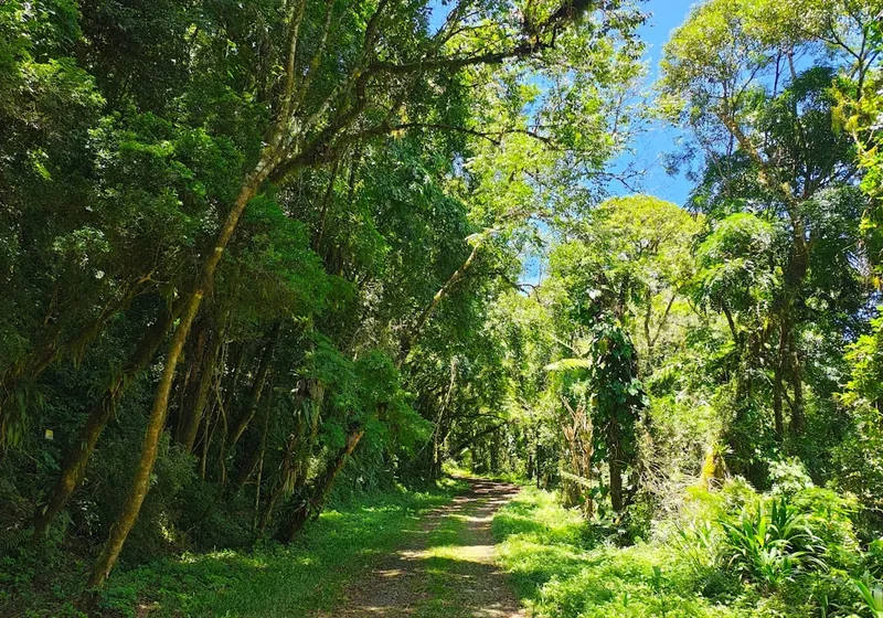
The Trilha da Cachoeira do Tabuleiro is a journey into a landscape sculpted by water and time. Starting from a modest elevation, the trail gradually ascends through a mosaic of cerrado vegetation, transitioning into denser Atlantic Forest remnants as it climbs. The path is well-trodden but can be challenging, with sections of rocky terrain, steep inclines, and stream crossings. The elevation gain of 600 metres over 11 kilometres means a consistent workout, making it a moderate to challenging day hike, particularly in warmer months.
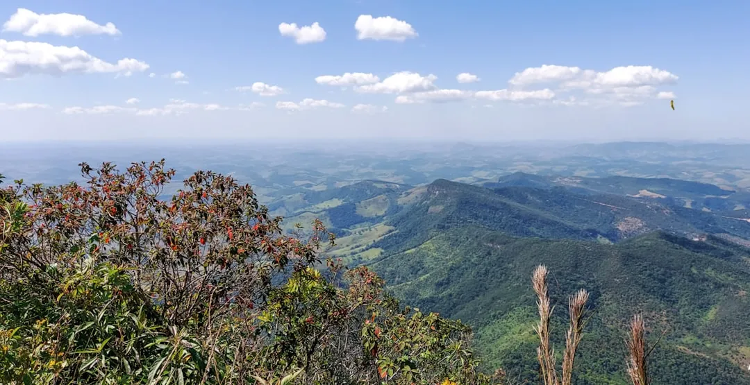
As you progress, the sounds of the forest intensify, and the air grows cooler, hinting at the approaching grandeur of the waterfall. The trail is not merely a path to a destination but an experience in itself, offering glimpses of local flora and fauna, and panoramic views of the surrounding valleys. The final approach to Cachoeira do Tabuleiro is marked by the increasing roar of falling water, a powerful auditory cue that builds anticipation.
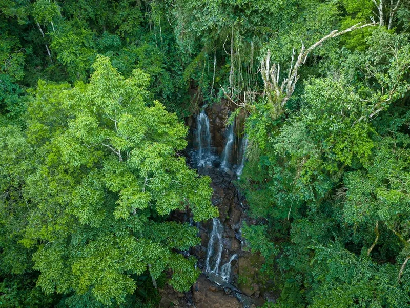
Upon arrival, the sheer scale of the waterfall is awe-inspiring. Cachoeira do Tabuleiro is a majestic sight, its water cascading down a sheer rock face into a large, natural pool. The mist generated by the falling water creates a refreshing microclimate, and the surrounding rocks offer natural seating to admire the spectacle. While swimming is possible in the pool, caution is advised due to the powerful currents and submerged rocks. The return journey offers a different perspective on the landscape, allowing for reflection on the natural beauty encountered.
History and Cultural Context
The region surrounding Conceição do Mato Dentro and the Serra do Espinhaço has a rich history deeply intertwined with Brazil's colonial past and its mineral wealth. This area was historically significant for mining, particularly for gold and diamonds, attracting prospectors and settlers for centuries. The rugged terrain and abundant natural resources shaped the lives and livelihoods of the communities that developed here.
The Trilha da Cachoeira do Tabuleiro, while not a historical route in the same vein as ancient pilgrimage paths, has been a local attraction for generations. Its accessibility has improved over time, transforming from a challenging trek known only to locals into a popular destination for ecotourism and adventure seekers. The trail's current form reflects a balance between preserving its natural state and facilitating visitor access.
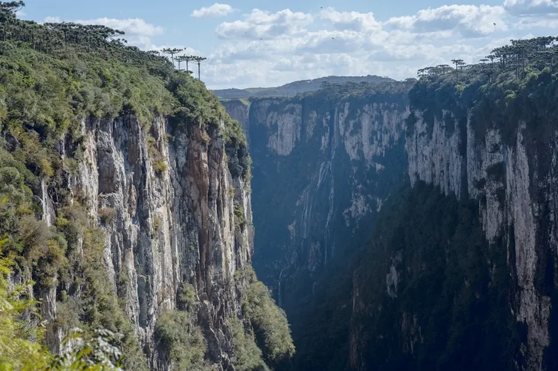
The Serra do Espinhaço itself is a geological marvel, a vast mountain range that stretches across Minas Gerais and Bahia, known for its unique biodiversity and mineral deposits. The presence of waterfalls like Tabuleiro is a testament to the region's hydrographic network, carved over millennia by the persistent action of water on the ancient rock formations. The cultural significance of the area also extends to its indigenous heritage, though specific historical records tied directly to this particular trail are scarce, the broader region holds deep ancestral connections for various indigenous groups.
Seasonal Highlights and Weather Reality
The Trilha da Cachoeira do Tabuleiro is best experienced during the dry season, which typically runs from April to September. During these months, rainfall is significantly reduced, leading to clearer skies, more stable weather conditions, and a lower risk of flash floods or impassable river crossings. The trails are generally drier and easier to navigate.
Dry Season (April to September): This is the prime time for hiking. Temperatures are generally pleasant, with daytime highs ranging from 20-25°C and cooler evenings. The reduced water flow in rivers makes crossings safer, and the vegetation is less dense, offering better visibility. The waterfall, while still impressive, may have less volume than during the wet season.
Wet Season (October to March): This period brings higher temperatures and humidity, with frequent and often heavy thunderstorms. While the increased rainfall can make the Cachoeira do Tabuleiro even more spectacular with a higher volume of water, the trail can become muddy, slippery, and potentially dangerous. River levels can rise rapidly, posing a significant risk for crossings. Some local guides may advise against hiking during periods of intense rain due to safety concerns.
Shoulder Seasons (March/April and September/October): These months can offer a good balance, with the tail end of the wet season or the beginning of the dry season. Weather can be more unpredictable, but you might experience fewer crowds and still enjoy a good volume of water at the falls.
Regardless of the season, always check the local weather forecast before setting out. The mountainous terrain can experience microclimates, and conditions can change rapidly.
Recommended Itinerary
Day Hike: Trilha da Cachoeira do Tabuleiro
Early Morning (Approx. 7:00 AM - 8:00 AM): Departure from Conceição do Mato Dentro
- Arrange for local transport (ideally a 4x4 vehicle) from Conceição do Mato Dentro to the trailhead. The journey takes approximately 1 hour and can be rough due to unpaved roads.
- Ensure you have had breakfast and are ready for an early start.
Morning (Approx. 8:00 AM - 9:00 AM): Arrival at Trailhead and Registration
- Arrive at the designated trailhead. There may be a small registration point or information centre where you can sign in.
- Final gear check: ensure you have water, snacks, sun protection, and appropriate footwear.
- Begin the hike. The initial section is relatively flat, allowing for warm-up.
Late Morning (Approx. 9:00 AM - 12:00 PM): Ascent through Cerrado and Forest
- The trail begins to gain elevation. You will pass through typical cerrado vegetation, characterized by scattered trees and shrubs.
- As you climb higher, the vegetation transitions into more dense Atlantic Forest remnants.
- The path can be rocky and uneven in places.
- Key Waypoints: Look for distinctive rock formations and changes in vegetation as indicators of progress.
Midday (Approx. 12:00 PM - 1:30 PM): Reaching the Waterfall and Lunch Break
- The sound of the waterfall will become increasingly audible.
- Arrive at Cachoeira do Tabuleiro. Spend time admiring the 180-metre cascade and its impressive pool.
- Find a suitable spot to rest and have your packed lunch.
- Optional: If conditions are safe and you are comfortable, you can take a dip in the pool at the base of the waterfall. Be extremely cautious of currents and submerged rocks.
Afternoon (Approx. 1:30 PM - 4:30 PM): Descent and Return to Trailhead
- Begin the descent back towards the trailhead. The downhill section can be as demanding as the ascent, requiring careful footing.
- Enjoy the changing light and perspectives of the landscape on your way down.
- Arrive back at the trailhead.
Late Afternoon (Approx. 4:30 PM onwards): Return to Conceição do Mato Dentro
- Meet your pre-arranged transport.
- Return to Conceição do Mato Dentro.
- Consider a well-deserved meal at a local restaurant to celebrate your hike.
Important Notes:
- This is a day hike; no overnight accommodation is required on the trail.
- Carry all your food and water; there are no facilities along the trail.
- Wear sturdy, closed-toe hiking boots.
- Sun protection (hat, sunscreen) is essential, even on cloudy days.
- Insect repellent is recommended, especially during warmer months.
- Inform someone of your hiking plans and expected return time.
Planning and Bookings
Book Your Trip
Everything you need to plan your journey
Accommodation
Find places to stay near Conceição do Mato Dentro
Flights
Search flights to Conceição do Mato Dentro
Essential Preparation
The Trilha da Cachoeira do Tabuleiro is a day hike, but its moderate difficulty and the remoteness of the trailhead necessitate careful planning. The closest major city with an airport is Belo Horizonte (CNF). From Belo Horizonte, you can take a bus to Conceição do Mato Dentro, a journey of approximately 3 hours. Once in Conceição do Mato Dentro, hiring a local taxi or, preferably, a 4x4 vehicle is essential to reach the trailhead. The road to the trailhead is unpaved and can be rough, especially after rain, making a standard car unsuitable.
It is highly recommended to arrange your transport to and from the trailhead in advance, especially if you are not familiar with the area. Staying overnight in Conceição do Mato Dentro before and after your hike is advisable to allow for flexibility with transport and to acclimatise to the region. The town offers basic accommodation and dining options.
Trail Accommodation
This is a day hike requiring no overnight accommodation.
Required Gear
- Hiking Boots: Sturdy, broken-in hiking boots with good ankle support and grip are essential for navigating the rocky and uneven terrain.
- Waterproof Jacket: Lightweight and breathable, suitable for sudden rain showers common in mountainous regions.
- Backpack: A comfortable daypack (20-30 litres) to carry essentials.
- Navigation: While the trail is generally well-marked, a map of the area or a GPS device/app with offline maps is recommended.
- First Aid Kit: A basic kit including plasters, antiseptic wipes, pain relievers, and any personal medications.
- Head Torch: Essential in case of unexpected delays, though unlikely for a day hike if started early.
What to Bring
- Food: Plenty of high-energy snacks (nuts, dried fruit, energy bars) and a packed lunch. There are no food services along the trail.
- Water: At least 2-3 litres of water per person. Water sources may be available but should be treated before consumption.
- Water Treatment: A water filter or purification tablets are highly recommended if you plan to refill from natural sources.
- Sun Protection: High SPF sunscreen, a wide-brimmed hat, and sunglasses. The sun can be intense, especially at higher elevations.
- Insect Repellent: Especially important during warmer months to ward off mosquitoes and other biting insects.
- Toiletries: Hand sanitiser, biodegradable wet wipes, and any personal hygiene items. Pack out all waste.
- Camera: To capture the stunning scenery and the magnificent waterfall.
- Cash: For potential local transport arrangements or small purchases in Conceição do Mato Dentro.
Permits
No specific permits are required to hike the Trilha da Cachoeira do Tabuleiro. However, it is recommended to register your visit at the trailhead if a designated point is available. This helps local authorities monitor visitor numbers and track potential safety incidents.
While no fees are associated with accessing the trail itself, you will incur costs for transportation to the trailhead, which often involves hiring local guides or 4x4 vehicles due to the road conditions. It is advisable to confirm any local access fees or registration requirements with your transport provider or accommodation in Conceição do Mato Dentro before your trip.
Other Activities in the Area
Conceição do Mato Dentro and its surroundings offer several other attractions for nature enthusiasts and cultural explorers:
- Cachoeira do Congonhas: Another beautiful waterfall in the region, often less crowded than Tabuleiro, offering a different but equally rewarding hiking experience.
- Cachoeira do Tabuleiro (Lower Falls): While the main attraction is the upper 180-metre cascade, there are smaller, more accessible falls downstream that can be visited.
- Parque Estadual do Pico do Itambé: For experienced hikers and those seeking a more challenging adventure, Pico do Itambé offers stunning panoramic views from its summit. This requires more significant planning and potentially overnight stays.
- Exploring Conceição do Mato Dentro: The town itself has a charming historic centre with colonial architecture, a main church (Igreja Matriz de Nossa Senhora da Conceição), and local markets where you can sample regional cuisine and crafts.
- Local Cuisine: Minas Gerais is renowned for its distinctive cuisine. Enjoy traditional dishes like pão de queijo, feijão tropeiro, and doce de leite in local restaurants.
- Rock Climbing and Rappelling: The dramatic rock formations in the Serra do Espinhaço attract climbers, and guided tours for rappelling down waterfalls (including Tabuleiro, with expert guidance) are sometimes available.
Safety and Conditions
Trail Conditions: The Trilha da Cachoeira do Tabuleiro is a natural trail with sections of uneven, rocky, and potentially slippery terrain. During the wet season, mud can make the path treacherous. Always wear appropriate footwear.
Weather: Mountain weather can change rapidly. Be prepared for sudden rain showers, strong winds, and temperature fluctuations. Check the forecast before you go and be ready to turn back if conditions deteriorate significantly.
Water Crossings: Several small streams may need to be crossed. During the wet season, these can become swollen and difficult to cross. Assess the depth and current carefully before attempting to cross. If in doubt, do not cross.
Hydration and Nutrition: Carry ample water and high-energy snacks. Dehydration and fatigue can increase the risk of accidents. Do not rely on finding potable water sources along the trail.
Wildlife: While generally not dangerous, be aware of local wildlife. Avoid disturbing animals and never feed them. Snakes and insects are present; watch where you step and sit.
Communication: Mobile phone signal is likely to be non-existent for most of the trail. Inform someone of your hiking plans, including your expected return time, and your route. Consider carrying a personal locator beacon (PLB) for remote areas.
Swimming: Swimming in the pool at the base of Cachoeira do Tabuleiro is possible but carries risks. The water can be cold, currents can be strong, and submerged rocks are present. Swim only if you are a strong swimmer and are aware of the conditions. Local advice should be sought.
Local Guides: Hiring a local guide is highly recommended, especially if you are unfamiliar with the area or hiking in Brazil. Guides can provide invaluable knowledge about the trail, local conditions, safety, and cultural insights.
Side Trips and Points of Interest
Cachoeira do Tabuleiro (Upper Falls): The primary destination, this magnificent 180-metre waterfall is the highlight of the hike. Its sheer drop and the powerful mist it generates are a spectacular sight. The pool at its base offers a refreshing, albeit cold, swimming opportunity for the brave.
The Pool at the Base: The large, clear pool formed by the falling water is a natural wonder. Surrounded by rocks and lush vegetation, it's an ideal spot for a picnic and to simply soak in the atmosphere. Be mindful of the water's depth and currents if you choose to swim.
Panoramic Views: As you ascend and descend, there are several points along the trail that offer expansive views of the surrounding Serra do Espinhaço landscape. These vistas provide a sense of the scale of the region and the geological forces that shaped it.
Flora and Fauna: The trail passes through diverse ecosystems, from open cerrado to denser Atlantic Forest. Keep an eye out for unique plant species, colourful birds, and other local wildlife that inhabit the area. The transition in vegetation as you gain altitude is a point of interest in itself.
Rock Formations: The Serra do Espinhaço is known for its striking geological formations. Along the trail, you will encounter various rock types and interesting shapes sculpted by erosion over millennia.
Leave No Trace
The Trilha da Cachoeira do Tabuleiro traverses a beautiful natural environment that deserves respect and preservation. Adhering to Leave No Trace principles ensures that this stunning location remains pristine for future visitors and for the health of the ecosystem.
Your responsibility as a hiker:
- Pack It In, Pack It Out: Carry out all litter, including food scraps, wrappers, and any other waste you generate. Do not bury or burn trash.
- Stay on the Trail: Stick to the marked path to prevent erosion and protect fragile vegetation. Venturing off-trail can damage the environment and increase your risk of getting lost.
- Respect Wildlife: Observe animals from a distance and never feed them. Feeding wildlife can alter their natural behaviour and diet, making them dependent on humans and potentially aggressive.
- Dispose of Waste Properly: Use designated toilet facilities if available at the trailhead. If not, dig a cathole at least 60 metres away from water sources, trails, and campsites, and bury human waste. Pack out toilet paper.
- Leave What You Find: Do not take rocks, plants, or any natural objects from the environment. Leave them for others to enjoy and for the ecosystem to thrive.
- Minimise Campfire Impacts: As this is a day hike, campfires are generally not applicable. However, if you were to camp, use established fire rings and ensure fires are completely extinguished.
- Be Considerate of Other Visitors: Keep noise levels down and yield to other hikers. Enjoy the natural sounds of the environment.
By following these principles, you help maintain the natural beauty and ecological integrity of the Trilha da Cachoeira do Tabuleiro and its surroundings.