
Table Mountain Platteklip Gorge - The Direct Ascent to the Sky
Table Mountain’s Platteklip Gorge is arguably the most iconic and frequented hiking route in South Africa. Serving as the most direct path to the summit of one of the New 7 Wonders of Nature, this trail is a relentless, steep, and rewarding "stairway to heaven" that carves through the massive sandstone ramparts of the mountain’s front face. While the distance is a deceptively short 3.0 kilometres, the vertical gain of 700 metres over that distance makes it a significant physical undertaking. The trail follows a natural cleft in the mountain, offering hikers a dramatic perspective of the sheer cliffs that define the Cape Town skyline. From the trailhead on Tafelberg Road to the upper plateau, the journey is a masterclass in Cape geology and botanical diversity, providing unparalleled views of the City Bowl, Table Bay, and the distant Boland Mountains.
- Distance: 3.0 km one-way (to the Upper Cable Station)
- Duration: 2–3 hours (ascent only)
- Season: Year-round (October to April is optimal for dry conditions)
- Difficulty: Moderate to Strenuous (due to steepness and exposure)
- Highest point: 1,067 m (at the summit plateau)
- Elevation Gain: 700 m
- Trailhead: Tafelberg Road, Cape Town
Overview
Platteklip Gorge, which translates from Afrikaans as "Flat Rock Gorge," is the quintessential Table Mountain experience for those who prefer to earn their views on foot rather than via the cable car. The trail is often described as a "giant's staircase," consisting of thousands of stone steps meticulously laid to manage the steep gradient and prevent erosion. Unlike the more forested routes on the eastern slopes, such as Skeleton Gorge, Platteklip is largely exposed to the elements, offering little shade but providing constant, breathtaking vistas of the Atlantic Ocean and the urban sprawl of Cape Town below.
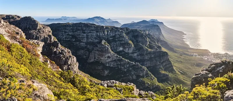
The landscape is dominated by the Cape Supergroup’s Table Mountain Sandstone, a hard, quartzitic rock that has resisted erosion for millions of years. As you ascend, you move through various layers of the Cape Floral Kingdom, the smallest yet most diverse of the world’s six floral kingdoms. The vegetation here is primarily fynbos—a Mediterranean-style shrubland characterised by proteas, ericas, and restios. The sheer scale of the gorge walls is humbling; at certain points, the cliffs rise hundreds of metres on either side, creating a natural amphitheatre that echoes with the calls of the Red-winged Starling and the occasional rustle of a Rock Hyrax (locally known as a "dassie") scurrying across the rocks.
While the trail is technically straightforward—requiring no rock climbing or specialised mountaineering skills—it demands a high level of cardiovascular fitness. The ascent is a test of endurance, particularly in the summer months when the African sun reflects off the light-coloured sandstone, creating a radiant heat that can be punishing. However, the reward at the top is one of the most famous panoramas on Earth: a 360-degree view that encompasses the Twelve Apostles mountain range, the Cape Peninsula stretching toward Cape Point, and the vast expanse of the South Atlantic. For many, the descent is handled by the Table Mountain Aerial Cableway, though the hardy can choose to hike back down the same way or explore the various contour paths that criss-cross the mountain’s face.
History and Cultural Context
Table Mountain, known to the indigenous Khoe-Sān people as *Huri ǂoaxa* (the Mountain in the Sea), has been a site of spiritual and practical significance for millennia. The Khoe-Sān were the original inhabitants of the Cape, and the mountain provided them with water, medicinal plants, and a landmark for navigation. Platteklip Gorge itself has likely been used as a route to the summit for as long as humans have inhabited the region, providing the most accessible break in the mountain's formidable northern cliffs.
The first recorded ascent of Table Mountain by a European was made via Platteklip Gorge in 1503 by the Portuguese explorer Antonio de Saldanha. He climbed the mountain to get his bearings after his fleet became separated, naming the bay below "Aguada de Saldanha" (now Table Bay). Since then, the gorge has hosted a long list of historical figures. In 1797, Lady Anne Barnard became the first woman of European descent to record her ascent of the mountain, a feat she accomplished in heavy Victorian skirts, accompanied by a party of friends and servants. Her detailed journals provide a fascinating glimpse into the early colonial perception of the mountain as a wild and untamed frontier.
The name "Platteklip" refers to the large, flat rocks found in the stream bed at the base of the gorge. In the 18th and 19th centuries, these rocks were used by the "washerwomen of Cape Town"—many of whom were enslaved people or poor freed citizens—who would carry heavy loads of laundry from the city to the mountain streams to wash them in the fresh, mountain water. Today, the trail is a protected part of the Table Mountain National Park, a UNESCO World Heritage Site, and serves as a symbol of Cape Town’s natural heritage and the enduring spirit of exploration that defines the city.
Want more background? Read extended notes on history and cultural context → Learn more
Seasonal Highlights and Weather Reality
The weather on Table Mountain is notoriously fickle, often described as having "four seasons in one day." Because Platteklip Gorge is located on the northern face, it is highly susceptible to the prevailing winds and solar radiation. Understanding the seasonal nuances is critical for a safe and enjoyable hike.
Summer (October to April): This is the most popular time to hike, characterised by long, sunny days and warm temperatures. However, summer also brings the "South Easter," a powerful wind known as the "Cape Doctor." This wind is responsible for the "Tablecloth"—a thick layer of orographic cloud that pours over the mountain’s edge. While spectacular to watch from below, being caught in the Tablecloth can lead to a sudden drop in temperature and near-zero visibility. Summer hikers must start early (ideally before 7:00 AM) to avoid the intense midday heat, as the gorge becomes a heat trap by noon.
Winter (May to September): The Cape winter is the rainy season. While the landscape becomes lush and the streams in the gorge begin to flow, the trail can become slippery and dangerous. Cold fronts from the Atlantic bring heavy rain and gale-force winds. However, between these fronts, Cape Town often experiences "crystal days"—crisp, clear, and cool days with perfect visibility. Hiking during these windows is magnificent, but one must be prepared for cold temperatures at the summit, which can hover near freezing.
Shoulder Seasons (April/May and September/October): These months often provide the best hiking conditions. The temperatures are moderate, the fynbos is often in bloom (particularly the spectacular Proteas in spring), and the wind is generally less aggressive than in mid-summer. The visibility is often at its best during these periods, allowing for views that stretch all the way to the Cedarberg Mountains, over 200 kilometres to the north.
Recommended Itinerary

Platteklip Gorge Route Progression
Phase 1: The Lower Contours (Tafelberg Road to Gorge Base)
- Distance: 0.5 km
- Elevation gain: 100 m
- Time: 20–30 minutes
- Start at the clearly marked trailhead on Tafelberg Road, approximately 1.5 km past the Lower Cable Station.
- The trail begins with a well-maintained gravel path that winds through low-lying fynbos.
- Cross the lower contour path, which runs horizontally across the mountain.
- This section is a gentle warm-up, offering views of Lion's Head and the Atlantic seaboard.
- Look out for the historic stone waterworks and the "Platteklip" stream crossings.
Phase 2: Entering the Gorge (The Lower Zig-Zags)
- Distance: 1.0 km
- Elevation gain: 250 m
- Time: 45–60 minutes
- The trail narrows and the gradient increases significantly as you enter the mouth of the gorge.
- The path transitions into a series of stone steps built into the mountainside.
- The cliffs of the gorge begin to tower above you, providing some shade in the very early morning.
- This is the section where the "stairmaster" effect begins; maintain a steady, rhythmic pace.
- Stop frequently to look back at the City Bowl and the harbour—the perspective changes rapidly with every 50 metres of gain.
Phase 3: The Mid-Section (The Heart of the Chute)
- Distance: 0.8 km
- Elevation gain: 200 m
- Time: 40–50 minutes
- The gorge tightens, and the trail becomes a relentless series of switchbacks (zig-zags).
- The vegetation changes as you gain altitude; look for hardy ericas and restios clinging to the rock faces.
- This section is the most physically demanding and is often the hottest part of the trail due to the lack of air movement within the high walls.
- Hydration is key here; there are no reliable water sources on the trail itself.
- You will likely encounter many other hikers; it is customary to give way to those ascending.
Phase 4: The Upper Chute and Summit Crest
- Distance: 0.7 km
- Elevation gain: 150 m
- Time: 30–40 minutes
- The final push toward the "skyline" where the gorge meets the upper plateau.
- The trail becomes steeper but the end is in sight as the V-shape of the gorge opens up to the sky.
- As you crest the ridge, the wind often picks up, providing a welcome cooling effect.
- The trail tops out at a signposted junction on the plateau.
- Turn right to head toward the Upper Cable Station (15-minute walk) or left to head toward Maclear's Beacon, the highest point on the mountain.
Important Notes:
- The trail is strictly for hiking; no mountain biking or dogs are permitted on this specific route.
- The descent can be harder on the knees than the ascent; many hikers choose to take the cable car down.
- Always check if the cable car is running before you start, as it closes in high winds.
- There are no toilets or facilities on the trail; the nearest are at the Lower and Upper Cable Stations.
- Cell phone reception is generally good but can be spotty within the deep sections of the gorge.
Planning and Bookings
Book Your Trip
Everything you need to plan your journey
Accommodation
Find places to stay near Cape Town
Flights
Search flights to Cape Town
Essential Preparation
Planning for Platteklip Gorge is less about permits and more about timing and physical readiness. Because it is a free-access trail within a National Park, no prior booking is required to hike. However, the logistical coordination of your transport is vital. Most hikers choose to park near the Lower Cable Station or use the MyCiTi bus service (Route 110), which drops passengers at the cableway. From there, it is a 1.5-kilometre walk along Tafelberg Road to the Platteklip trailhead.
Fitness is the most critical preparation. While the trail is short, it is a 700-metre vertical climb. If you are not accustomed to steep inclines, your calves and quads will feel the strain. It is highly recommended to do a few smaller hills or stair-climbing sessions in the weeks leading up to your hike. Additionally, ensure you have downloaded an offline map of Table Mountain, as the network of trails on the plateau can be confusing if the mist rolls in.
Trail Accommodation
This is a day hike requiring no overnight accommodation on the trail itself. Most hikers complete the ascent in 2 to 3 hours and either hike down or take the cable car. For those wishing to stay near the mountain, Cape Town offers a vast array of options:
- Gardens and Oranjezicht: These suburbs sit directly at the foot of the mountain and offer numerous boutique hotels, guesthouses, and backpacker hostels. Staying here allows for a very early start.
- Overseas Visitors: Many choose to stay in the City Bowl or the V&A Waterfront, which are a 10-to-15-minute Uber or taxi ride from the trailhead.
- SANParks Accommodation: For a unique experience, the South African National Parks (SANParks) offers the "Platteklip Wash House" at the base of the mountain, which provides self-catering accommodation in a beautifully restored historic building.
Required Gear
- Footwear: Sturdy hiking boots or high-quality trail running shoes with good grip. The stone steps can be uneven and slippery when wet.
- Sun Protection: A wide-brimmed hat, high-SPF sunscreen, and UV-protective sunglasses. The gorge is highly exposed.
- Clothing: Moisture-wicking base layers. Avoid cotton, which stays wet and cold. Even in summer, bring a lightweight windbreaker or fleece, as the temperature at the summit is significantly lower than at the base.
- Navigation: A fully charged smartphone with a GPS app (like AllTrails or Strava) and a backup power bank.
- Communication: A mobile phone with local emergency numbers saved (Table Mountain Emergency: +27 21 937 0300).
What to Bring
- Water: Minimum 2–3 litres per person. There is no potable water on the trail, and dehydration is the leading cause of mountain rescues on Platteklip.
- Snacks: High-energy foods such as nuts, dried fruit, energy bars, or biltong (South African dried meat).
- First Aid: A basic kit containing plasters (bandaids), antiseptic wipes, and any personal medication.
- Trash Bag: A small bag to carry out all your waste, including fruit peels and tissues.
- Cash/Card: For the cable car ticket (if you plan to ride down) and for refreshments at the Upper Cable Station café.
Permits
One of the great appeals of Platteklip Gorge is that it is a free-access trail. No permits are required for individual hikers or small groups to ascend the mountain via this route. The trail falls within the Table Mountain National Park, which is managed by SANParks, but unlike many other South African parks, there is no entrance gate or fee for this specific trailhead.
Important Considerations:
- Commercial Groups: If you are leading a guided tour for profit, you must have a valid commercial operator's permit from SANParks.
- Cableway Tickets: While the hike is free, the Table Mountain Aerial Cableway is a private operation. If you intend to take the cable car down, it is highly recommended to buy your ticket online in advance to avoid long queues at the summit ticket office. Prices vary by season and time of day (morning vs. afternoon).
- Operating Hours: The cableway's operation is entirely weather-dependent. If the wind exceeds a certain threshold, the service is suspended. Always check the live status on the official Table Mountain Cableway website before you start your hike.
- Parking: Parking along Tafelberg Road is free but extremely limited. During peak season (December and January), parking can be backed up for kilometres. Arriving before 7:30 AM is essential to secure a spot near the trailhead.
Other Activities in the Area
Cape Town is a world-class destination with a wealth of activities to complement your hike:
- Lion's Head: The neighbouring peak offers a shorter, more social hike with incredible sunset views. It involves some light scrambling and ladder climbing.
- Kirstenbosch National Botanical Garden: Located on the eastern slopes of the mountain, this is one of the world's great botanical gardens. You can hike from Kirstenbosch to the summit via Skeleton Gorge or Nursery Ravine.
- Robben Island: Take a ferry from the V&A Waterfront to visit the historic prison where Nelson Mandela was held, offering a profound look into South Africa's journey to democracy.
- Cape Point and Boulders Beach: A day trip south to the tip of the peninsula to see the dramatic cliffs of Cape Point and the famous African Penguin colony at Boulders Beach.
- Signal Hill: Drive up for a sundowner and watch the paragliders launch over the Atlantic Seaboard.
- Wine Tasting: The Constantia Wine Valley is located on the back slopes of Table Mountain, offering world-class vineyards just 20 minutes from the city centre.
Safety and Conditions
Pre-Departure Checks:
- Check the weather forecast specifically for Table Mountain, not just Cape Town city. The mountain creates its own microclimate.
- Save the Table Mountain Emergency number (+27 21 937 0300) and the general emergency number (107 from a landline or 112 from a mobile).
- Tell someone exactly which route you are taking and when you expect to be back.
- Check the Cableway's Twitter/X feed or website for live operational status.
Heat and Hydration: Heatstroke is the most common danger on Platteklip Gorge. The trail is north-facing and acts as a sun trap. There is zero shade for 90% of the route. Hikers often underestimate the intensity of the African sun. If you feel dizzy, nauseous, or develop a headache, stop immediately in whatever sliver of shade you can find, drink water, and do not continue upward until you feel stable.
The "Tablecloth" Trap: When the South Easter wind blows, clouds can form on the summit in minutes. This "Tablecloth" can reduce visibility to less than five metres. If you are on the plateau and the mist rolls in, stay on the marked paths. The plateau is a labyrinth of rocks and bushes, and it is very easy to become disoriented and walk off a cliff edge. If you are lost in the mist, stay put and call for help rather than wandering.
Crime and Personal Safety: While Table Mountain is generally safe, it is a wilderness area adjacent to a major city. It is strongly advised to hike in groups of at least three people. Avoid carrying large amounts of cash or wearing expensive jewellery. Stick to the main Platteklip path, which is usually busy enough to provide "safety in numbers."
Mountain Rescue: The Wilderness Search and Rescue (WSAR) team is a highly professional volunteer organisation. If you or someone in your party is injured, stay calm, provide your exact location (GPS coordinates from your phone are best), and wait for instructions. Do not attempt to move someone with a suspected spinal or leg injury unless they are in immediate danger from rockfall.
Side Trips and Points of Interest
Maclear's Beacon: Once you reach the top of Platteklip Gorge, a 45-minute walk across the plateau will take you to Maclear's Beacon. At 1,087 metres, this is the highest point on Table Mountain. It is marked by a large stone cairn built by Sir Thomas Maclear in 1844 for a trigonometric survey. The walk to the beacon takes you through the heart of the summit fynbos and offers views toward False Bay.
The Upper Cable Station: Even if you don't ride the cable car, the station is worth a visit. It features several lookout decks, a café, and a gift shop. The "Sky-Hi" walk around the station provides some of the most vertigo-inducing views of the sheer cliffs dropping into the Atlantic.
The Valley of the Red Gods: For those with extra energy, a detour toward the Twelve Apostles side of the mountain leads to the Valley of the Red Gods and the Valley of Isolation. these areas are much quieter than the main plateau and offer a sense of the mountain's vastness and silence.
Echo Valley: Located between Platteklip and the reservoirs on the back table, this valley is known for its impressive acoustics and unique high-altitude wetlands. It is a great place to see the rare Disa uniflora (the "Pride of Table Mountain" orchid) if you are visiting in late January or February.
Leave No Trace
Table Mountain National Park is a fragile ecosystem under immense pressure from millions of annual visitors. As a hiker, you are a steward of this World Heritage Site. The fynbos vegetation is highly susceptible to trampling and fire.
Your responsibility as a walker:
- Stay on the Path: Platteklip Gorge is heavily eroded. Stepping off the stone stairs destroys the small plants that hold the soil together, leading to further degradation.
- No Fires: Smoking and open fires are strictly prohibited. Table Mountain is a tinderbox, and a single spark can cause a catastrophic wildfire that endangers lives and destroys biodiversity.
- Take Your Trash: This includes "organic" waste like orange peels and banana skins. In the nutrient-poor fynbos soil, these take a long time to decompose and can encourage invasive species or pests.
- Respect the Wildlife: Do not feed the dassies or birds. Feeding them makes them aggressive and dependent on human food, which is detrimental to their health.
- Silence is Golden: Keep noise to a minimum. Many people hike to escape the city's din; respect their right to experience the sounds of nature.
- Water Conservation: Do not use soaps or detergents in the mountain streams. These are vital water sources for the local fauna.