
Table Mountain via Platteklip Gorge - The Stairway to the Sky
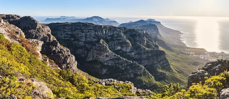
Table Mountain is not merely a backdrop to the city of Cape Town; it is the ancient, sandstone heart of South Africa’s "Mother City." Rising 1,086 metres above the Atlantic Ocean, this UNESCO World Heritage site is one of the New 7 Wonders of Nature. While there are over 350 recognised routes to the summit, Platteklip Gorge remains the most iconic, direct, and popular path for those seeking to conquer the mountain on foot. Often described as a "giant natural staircase," the gorge is a dramatic cleft in the mountain’s northern face, offering a relentless but rewarding ascent that provides unparalleled views of the city bowl, the harbour, and the vast expanse of Table Bay. This is a hike that demands physical stamina and respect for the mountain’s volatile weather, but it rewards every step with a sense of scale and geological grandeur that few urban hikes in the world can match.
- Distance: 6.0 km return (or 3.0 km one-way if using the cableway)
- Elevation Gain: 700 m
- Duration: 2–3 hours (ascent only)
- Difficulty: Moderate (physically demanding due to steepness)
- Best Time: October to April (summer months for stable weather)
- Closest City: Cape Town, South Africa
- Trailhead: Tafelberg Road, approximately 1.5 km past the Lower Cable Station
Overview
Platteklip Gorge (meaning "Flat Stone Gorge" in Afrikaans) is the oldest and most straightforward route up Table Mountain. It follows a deep, shaded ravine that cuts through the massive sandstone ramparts of the mountain's front face. Unlike the more technical routes like India Venster or the forested scrambles of Skeleton Gorge, Platteklip is a well-constructed trail consisting of thousands of stone steps. However, do not let the lack of technical climbing fool you; the ascent is a sustained, high-gradient climb that tests the cardiovascular fitness of even seasoned hikers. The path is hemmed in by towering cliffs that provide welcome shade in the early morning, but as the sun rises, the gorge can become a heat trap, reflecting the intense South African sun off the light-coloured rock.
The experience of hiking Platteklip is one of vertical progression. As you ascend, the city of Cape Town begins to shrink below you. The skyscrapers of the Central Business District, the colourful houses of Bo-Kaap, and the iconic bowl of the DHL Stadium become miniature models in a vast landscape. The geology of the gorge is a masterclass in deep time. You are walking through Table Mountain Sandstone, a resilient rock formation that has withstood hundreds of millions of years of erosion. The sheer walls of the gorge reveal the horizontal bedding of the sediment, laid down in an ancient sea long before the continents took their current form.
Reaching the top of the gorge—the "Upper Table"—is a moment of profound transition. The narrow, enclosed world of the ravine suddenly opens up into the vast, flat plateau that gives the mountain its name. From here, the wind often picks up, and the temperature can drop by several degrees in an instant. The summit is not just a peak but a sprawling wilderness of fynbos—a unique floral kingdom found nowhere else on Earth. Whether you choose to walk back down the same way or take the effortless ride on the Table Mountain Aerial Cableway, the Platteklip Gorge route provides the most visceral connection to the mountain’s physical presence.
History and Cultural Context
Table Mountain, known as *Hoerikwaggo* ("Mountain in the Sea") by the indigenous Khoisan people, has been a site of spiritual and practical significance for millennia. The Khoisan were the original inhabitants of the Cape, and the mountain provided them with fresh water, medicinal plants, and a vantage point to observe the seasonal migrations of game. For the Khoisan, the mountain was a sacred space, often associated with the Great Spirit, and its presence dominated their cosmology and daily life.
The first recorded ascent of Table Mountain by a European was in 1503 by the Portuguese explorer Antonio de Saldanha. He climbed the mountain via Platteklip Gorge to get his bearings after his fleet had become lost. Upon reaching the summit, he named the bay below *Aguada de Saldanha* (Watering Place of Saldanha), though it was later renamed Table Bay. Saldanha’s ascent marked the beginning of a long history of European fascination with the mountain. Throughout the 17th and 18th centuries, as Cape Town grew as a victualling station for the Dutch East India Company, the mountain became a source of timber and water, but also a formidable barrier to the interior.
In the Victorian era, hiking Table Mountain became a popular pastime for the residents of Cape Town. Platteklip Gorge was the primary route, and early hikers would often spend the night on the summit to witness the sunrise. The construction of the Table Mountain Aerial Cableway in 1929 transformed the mountain from a hiker’s preserve into a global tourist destination, but the allure of the "hard way up" remained. Today, the trail is a melting pot of local trail runners, international tourists, and spiritual seekers, all following in the footsteps of Saldanha and the Khoisan before him. The mountain remains a symbol of resilience and a central pillar of Cape Town’s identity, standing as a silent witness to the city’s complex history of colonialism, apartheid, and its eventual transition to democracy.
Want more background? Read extended notes on history and cultural context → Learn more
Seasonal Highlights and Weather Reality
The weather on Table Mountain is notoriously unpredictable, often described as having "four seasons in one day." Because the mountain stands at the confluence of two great oceans—the Atlantic and the Indian—it creates its own microclimate. Understanding the seasonal variations is crucial for a safe and enjoyable hike up Platteklip Gorge.
Summer (October to April): This is the most popular time to hike, characterised by long, sunny days and warm temperatures. However, summer also brings the "South-Easter," a powerful wind known locally as the "Cape Doctor." This wind pushes moist air up the mountain slopes, where it condenses into a thick layer of white cloud that spills over the edge like a tablecloth. While the "Tablecloth" is a beautiful sight from below, it can be dangerous for hikers, as visibility can drop to near zero and temperatures can plummet. In peak summer (January and February), the heat in Platteklip Gorge can be intense, often exceeding 30 degrees Celsius. It is essential to start your hike at sunrise to avoid the midday sun.
Winter (May to September): Cape Town receives most of its rainfall during the winter months. The mountain becomes lush and green, and the streams in the gorge flow with fresh water. Hiking during this time offers a different kind of beauty, with dramatic clouds and crisp air. However, the stone steps of Platteklip can become extremely slippery when wet, and the gorge can act as a funnel for cold, rain-bearing winds from the north-west. Snow is rare but does occasionally fall on the highest peaks of the plateau. Winter hikers must be prepared for sudden rainstorms and should always check the forecast for "cold fronts" moving in from the Atlantic.
Shoulder Seasons (April/May and September/October): These are often the best times for hiking. The wind is generally calmer than in summer, and the temperatures are more moderate. The fynbos is often in spectacular bloom during the spring (September), with proteas, ericas, and orchids adding splashes of colour to the grey sandstone landscape. The light during these months is also particularly beautiful for photography, with softer shadows and clearer horizons.
Recommended Itinerary

Platteklip Gorge Day Hike Itinerary
Early Morning: The Approach
- 06:30 – 07:00: Arrive at the trailhead on Tafelberg Road. Parking is limited, so an early start is essential to secure a spot near the start of the trail.
- Ensure you have at least 2 litres of water and have applied high-factor sunscreen.
- The trailhead is clearly marked with a SANParks (South African National Parks) signpost.
- The first few hundred metres are a gentle traverse along the base of the cliffs, allowing your legs to warm up before the vertical work begins.
Morning: The Ascent
- 07:00 – 08:30: Enter the gorge itself. The trail begins its relentless zigzag pattern.
- The path consists of well-maintained stone steps. Focus on a steady rhythm rather than speed.
- Take frequent short breaks to look back at the view. The higher you go, the more the Cape Town harbour and Robben Island come into focus.
- Midway up the gorge, the walls narrow, providing shade in the early morning. This is a good spot for a quick snack and water break.
- Listen for the calls of the Orange-breasted Sunbird or the rustle of a Rock Hyrax (Dassie) among the boulders.
Late Morning: The Summit Push
- 08:30 – 09:30: The final section of the gorge is the steepest. The "skyline" at the top of the gorge seems tantalisingly close but requires a final, concerted effort.
- As you crest the top of the gorge, the terrain levels out instantly. You have reached the Upper Table.
- Follow the signs toward the Upper Cable Station (about a 10–15 minute flat walk).
- Spend time exploring the various lookout points. The view from the Western Table toward Lion's Head and the Atlantic Seaboard is world-class.
- Optional: Walk an additional 45 minutes (one-way) to Maclear’s Beacon, the highest point on the mountain at 1,086 metres.
Midday: The Descent
- 10:30 – 11:30: Decide on your descent. Many hikers choose to take the Table Mountain Aerial Cableway down to save their knees (ensure you have checked if the cableway is running, as it closes in high winds).
- If walking down, return via the same Platteklip Gorge route. Be aware that the descent can be harder on the joints than the ascent; take your time on the steps.
- 12:30: Arrive back at Tafelberg Road. Head into the city or to the nearby Camps Bay beachfront for a well-deserved lunch.
Important Notes:
- The cableway is weather-dependent. If the "Tablecloth" cloud descends or winds exceed 30 km/h, the cableway will close, and you MUST be prepared to walk down.
- There is no water available on the trail itself; you must carry everything you need.
- Cell phone reception is generally good in the gorge but can be spotty on the plateau.
- Always hike in a group of at least two or three people for safety.
Planning and Bookings
Book Your Trip
Everything you need to plan your journey
Accommodation
Find places to stay near Cape Town
Flights
Search flights to Cape Town
Essential Preparation
While Platteklip Gorge is a popular and well-trodden path, it should not be treated as a casual stroll. The primary requirement is a moderate level of cardiovascular fitness. The "stairmaster" nature of the trail can be taxing on the heart and lungs, especially in the heat. If you are not accustomed to steep inclines, consider doing some preparatory walks or gym work in the weeks leading up to your hike.
Logistically, the hike is very accessible. Most visitors base themselves in Cape Town city centre, Sea Point, or Gardens. From these areas, the trailhead is a 10–15 minute drive. Uber is a highly reliable and recommended way to reach the trailhead, as it eliminates the stress of finding parking on the narrow Tafelberg Road. If you are driving yourself, arrive before 07:30, especially on weekends and during the December holiday season. The MyCiTi bus service also runs to the Lower Cable Station, from where you can walk the 1.5 km to the Platteklip trailhead.
Trail Accommodation
This is a day hike requiring no overnight accommodation on the trail itself. The vast majority of hikers complete the route in 3 to 5 hours and return to their accommodation in Cape Town. However, for those looking for a multi-day experience on the mountain, SANParks operates the "Hoerikwaggo Trail," which includes overnight stays in tented camps like the Orange Kloof Tented Camp or the Overseer’s Cottage. These require advanced booking through the SANParks website and are located on different parts of the mountain, not directly in Platteklip Gorge.
For the Platteklip hike, your "base camp" will be the city of Cape Town. There are hundreds of options ranging from luxury hotels at the V&A Waterfront to boutique guest houses in Tamboerskloof and budget-friendly backpackers in Long Street. Staying in the "City Bowl" area provides the easiest access to the mountain.
Required Gear
- Footwear: Sturdy trail running shoes or hiking boots with good grip. The stone steps can be uneven and slippery. Avoid flip-flops or smooth-soled fashion sneakers.
- Clothing: Use a layering system. Even if it is hot at the bottom, the summit can be cold and windy. A moisture-wicking base layer, a lightweight fleece, and a windproof/waterproof shell jacket are essential.
- Sun Protection: A wide-brimmed hat or cap, high-quality sunglasses, and SPF 50+ sunscreen. The African sun is exceptionally strong, and there is very little shade in the upper half of the gorge.
- Backpack: A small daypack (15–25 litres) to carry your water, food, and extra clothing. Ensure it has a comfortable waist or chest strap to distribute the weight.
- Navigation: While the trail is well-marked, having a digital map (like AllTrails or Google Maps) or a physical map of Table Mountain National Park is recommended.
What to Bring
- Water: Minimum 2 litres per person. In summer, 3 litres is safer. There are no taps or reliable streams in the gorge.
- Food: High-energy snacks such as nuts, dried fruit, energy bars, and a sandwich for the summit. Salty snacks are also helpful to replace electrolytes lost through sweat.
- Communication: A fully charged mobile phone. Save the Table Mountain emergency numbers (see Safety section) before you start. A portable power bank is a wise addition.
- First Aid: A basic kit containing plasters (for blisters), antiseptic wipes, and any personal medication (e.g., asthma pumps or allergy medication).
- Whistle: For signalling in case of thick mist or emergency.
- Cash/Card: If you plan to take the cableway down or buy a coffee/snack at the summit restaurant.
Permits
One of the great advantages of the Platteklip Gorge route is that no permits are required for individual hikers. Table Mountain National Park is an open-access park for most of its hiking trails. You can simply arrive at the trailhead and begin your ascent. There are no entrance fees for the Platteklip Gorge trail itself.
Cableway Tickets:
While the hike is free, most people choose to take the Table Mountain Aerial Cableway for the descent. It is highly recommended to book your cableway tickets online in advance. This allows you to skip the ticket office queue at the top, although you will still need to queue for the cable car itself. Tickets can be purchased for a "One Way" descent. Be aware that the cableway is strictly weather-dependent. If the wind is too strong, the cableway will close, and you will have to walk back down the gorge. Always check the live status on the official Table Mountain Cableway website before you start your hike.
Commercial Groups:
If you are an organised group or a commercial guide leading a tour, you may require a specific permit from SANParks. However, for the average recreational hiker or tourist, no paperwork is necessary. Simply respect the park rules, stay on the path, and enjoy the mountain.
Parking:
There is no fee for parking along Tafelberg Road, but it is "park at your own risk." Do not leave any valuables visible in your car, as opportunistic theft can occur. During peak season, parking attendants (informal but often helpful) may assist you in finding a spot; a small tip (R5–R10) is customary if they help you.
Other Activities in the Area
Cape Town is a world-class destination with a wealth of activities within a short distance of Table Mountain:
- Lion's Head: The neighbouring peak to Table Mountain offers a shorter, more social hike with incredible 360-degree views. It is particularly popular for "Full Moon" hikes.
- Kirstenbosch National Botanical Garden: Located on the eastern slopes of the mountain, this is one of the world's great botanical gardens. It features the "Boomslang" canopy walkway and is the starting point for the Skeleton Gorge hike.
- V&A Waterfront: A bustling hub of shopping, dining, and entertainment. It is also the departure point for the ferry to Robben Island, where Nelson Mandela was imprisoned.
- Camps Bay and Clifton Beaches: After a hot hike, there is nothing better than a dip in the (admittedly chilly) Atlantic Ocean. These beaches offer white sand and a vibrant sunset strip of bars and restaurants.
- Signal Hill: A great spot for a sundowner drive, offering views of the city and the Atlantic Seaboard without the effort of a hike. It is also the launch site for tandem paragliding.
- The Pipe Track: A flat, easy walk that follows the old water pipes along the Atlantic side of the mountain. Perfect for those who want the views without the vertical climb.
Safety and Conditions
Emergency Contact Numbers:
- Table Mountain Emergency (Metro Rescue): +27 (0)21 937 0300
- SANParks Emergency: +27 (0)86 110 6417
- General Emergency: 107 (from a landline) or 112 (from a mobile)
Weather Hazards: The most common safety issue on Table Mountain is the weather. The "Tablecloth" cloud can descend in minutes, reducing visibility to less than 5 metres. If you are caught in thick mist, stay on the marked path. If you lose the path, stay where you are and call for help. Do not attempt to "shortcut" down the cliffs. Hypothermia is a genuine risk on the summit, even in summer, if you are wet and the wind picks up. Always carry a windproof jacket.
Heat and Dehydration: Platteklip Gorge is a north-facing ravine, meaning it catches the full force of the sun for much of the day. Heatstroke and dehydration are frequent occurrences. Drink water regularly, even if you don't feel thirsty, and wear a hat. If you start to feel dizzy or nauseous, find shade immediately and rest.
Crime: While Table Mountain is generally safe, it is an urban national park, and incidents of mugging have occurred. To minimise risk: hike in groups, avoid carrying large amounts of cash or expensive jewellery, and stay on the main trails. Be aware of your surroundings and report any suspicious activity to the SANParks rangers.
Technical Safety: Platteklip is not a technical climb, but the steps are high and can be taxing on the knees. Ankle sprains are the most common injury. Wear shoes with good ankle support and take care on the descent. If you are hiking alone, always tell someone your intended route and estimated return time.
Side Trips and Points of Interest
Maclear’s Beacon: This is the highest point on Table Mountain, marked by a large stone cairn. It was built by Sir Thomas Maclear in 1844 as a triangulation station for a trigonometric survey. The walk from the top of Platteklip Gorge to the beacon takes about 45 minutes across the flat plateau. The path is well-marked and takes you through beautiful sections of fynbos. The view from the beacon looks south toward the Cape Peninsula and False Bay.
The Upper Cable Station: Even if you don't use the cable car, the station area is worth a visit. It has a restaurant, a cocktail bar, and several paved pathways with telescopes and information boards. The "Western Table" views from here are the most famous, looking down over Lion's Head and the Twelve Apostles mountain range.
Echo Valley and Valley of the Red Gods: For those with more time and energy, the paths leading away from the top of Platteklip toward the back of the mountain are spectacular. Echo Valley is a deep, forested depression that feels miles away from the city. The Valley of the Red Gods offers dramatic rock formations and a sense of true wilderness. These areas are much quieter than the main Platteklip route.
The Dassies: You are almost guaranteed to see Rock Hyraxes (Dassies) at the summit. Despite looking like large rodents, their closest living relative is actually the elephant. They are habituated to humans but should never be fed, as they can bite and human food is harmful to them.
Leave No Trace
Table Mountain is a fragile ecosystem. The fynbos biome is one of the most biodiverse areas on the planet, with more plant species per square kilometre than the Amazon rainforest. Many of these species are found only on this mountain. As a hiker, you have a responsibility to protect this heritage.
The Principles of Leave No Trace:
- Stay on the Path: Cutting corners on the zigzags causes erosion and destroys delicate plants. The stone steps are there for a reason—use them.
- Pack It In, Pack It Out: There are no bins on the trail. Take all your litter, including organic waste like orange peels and apple cores, back down with you. Organic waste does not "decompose" quickly in this environment and can attract pests.
- No Fires: Table Mountain is extremely fire-prone. A single cigarette butt or a small cooking fire can devastate thousands of hectares of fynbos and threaten homes in the city below. Smoking is strongly discouraged on the trail.
- Respect Wildlife: Do not feed the dassies, birds, or any other animals. Observe them from a distance.
- Leave What You Find: Do not pick flowers or remove rocks. The "King Protea" is a magnificent sight, but it belongs on the mountain, not in a vase.
- Be Considerate: Keep noise levels down. Many people hike the mountain for peace and solitude. If you must use a phone, use headphones.