Svaneti Panorama Trail - The Throne of the Great Caucasus
The Svaneti Panorama Trail is Georgia’s most spectacular high-altitude odyssey—a 55-kilometre journey through the rugged heart of the Greater Caucasus Mountains. Located in the ancient region of Upper Svaneti, a UNESCO World Heritage site, this trail offers a profound immersion into a landscape where medieval stone towers stand guard over emerald valleys and jagged, ice-clad peaks pierce the sky. Unlike the more crowded village-to-village routes, the Panorama Trail prioritises elevation and exposure, tracing dramatic ridgelines that provide 360-degree views of the region’s most iconic giants, including the double-headed peak of Mt Ushba and the massive wall of Shkhara. This is a route that demands physical resilience and a spirit of adventure, rewarding walkers with a sense of isolation and grandeur that is increasingly rare in the modern world. To walk the Svaneti Panorama is to step back in time, traversing a land where the traditions of the Svan people remain as steadfast as the granite mountains they inhabit.
- Distance: 55.0 km total
- Duration: 4–5 days
- Season: June to September (high summer is essential for pass accessibility)
- Accommodation: A mix of wild camping and traditional Svan guesthouses
- Highest point: Guli Pass (2,954 m) or optional ridges up to 3,200 m
- Difficulty: Challenging (significant elevation gain and steep, technical descents)
- Direction: Generally walked from Mestia to the western villages (Etseri/Pari)
Overview
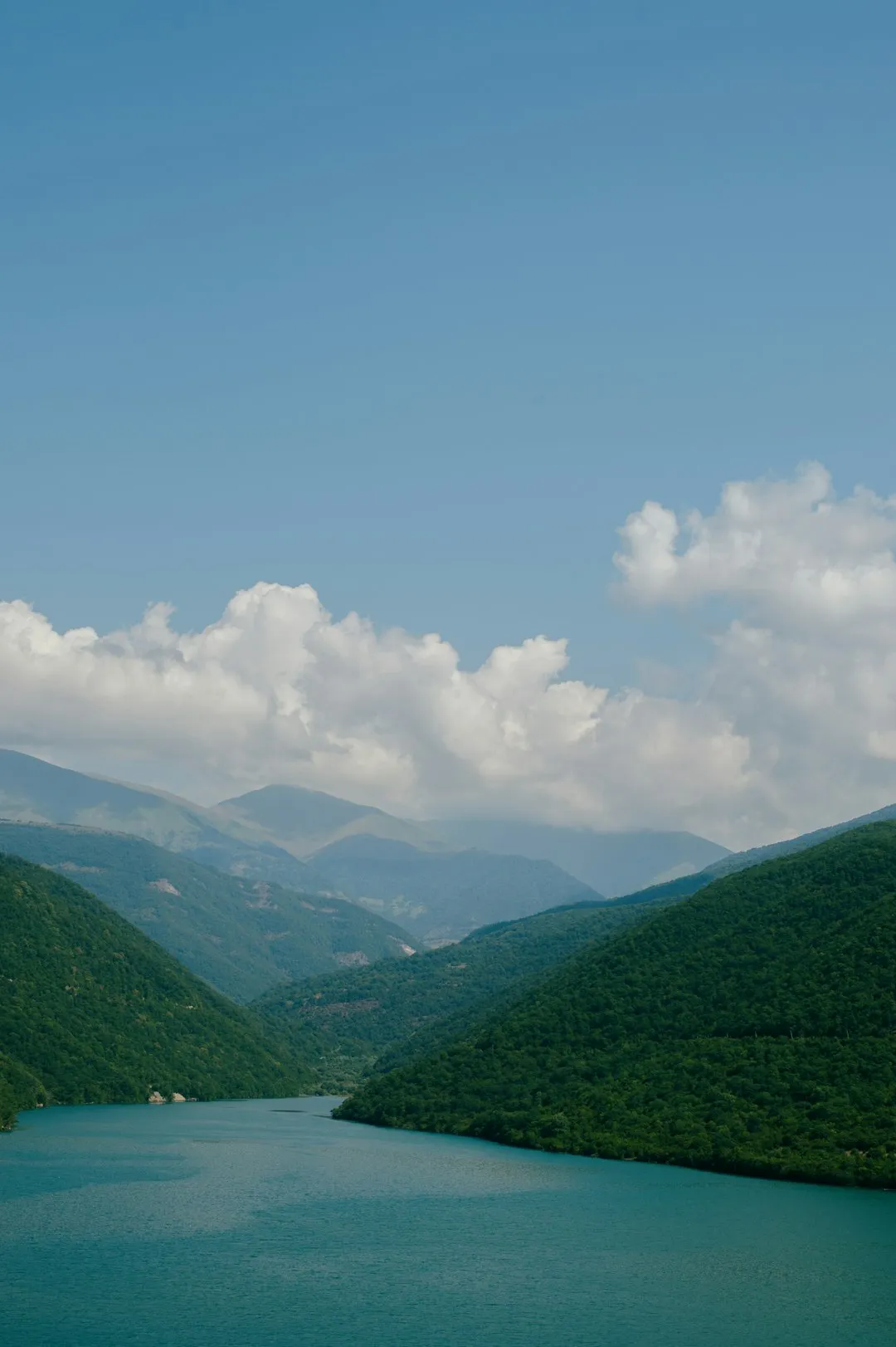
The Svaneti Panorama Trail is often described as the "high road" of Georgian trekking. While the popular Mestia-to-Ushguli route winds through valley floors and inhabited villages, the Panorama Trail seeks the sky. It is designed for those who wish to escape the valley dust and stand eye-to-eye with the glaciers. The route begins in Mestia, the regional capital, and immediately challenges walkers with a relentless ascent to the Koruldi Lakes—a series of alpine tarns that reflect the surrounding peaks like shattered mirrors. From here, the trail stays high, traversing the Guli Pass and skirting the base of Mt Ushba, arguably the most beautiful and intimidating mountain in the entire Caucasus range.
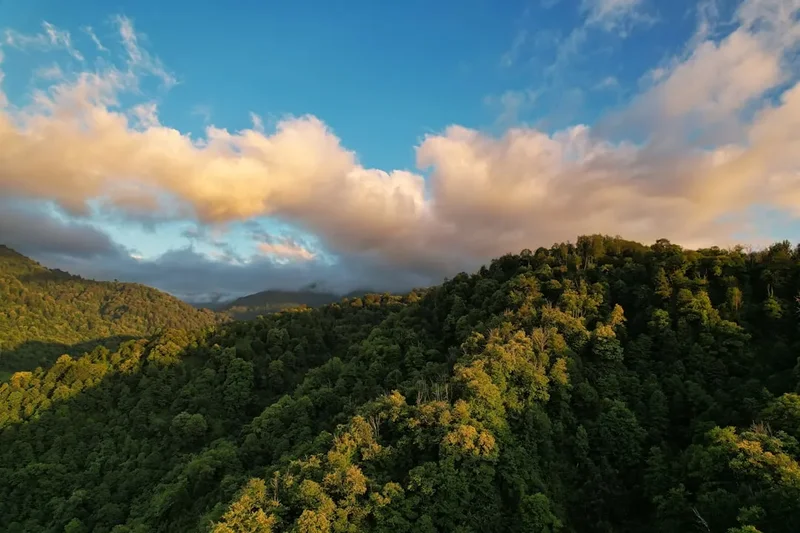
The landscape is one of extreme contrasts. You will move from the humid, lush forests of the lower valleys, where ancient walnut trees and wild rhododendrons thrive, into the stark, monochromatic world of the high alpine zone. Above 2,500 metres, the trees vanish, replaced by vast meadows of wildflowers that bloom in a frantic riot of colour during the short summer window. The geological scale here is humbling; the Caucasus are younger and more jagged than the Alps, creating a verticality that can feel overwhelming. The trail is not merely a physical path but a visual narrative of the Earth’s tectonic power, with folded limestone and dark shales forming the backdrop to your journey.
What sets this trail apart is the "Panorama" itself. For much of the middle three days, you are walking along ridges or high balconies. To the north, the Russian border is marked by a wall of 4,000 and 5,000-metre peaks. To the south, the Svaneti Range rolls away toward the Black Sea. The silence at these heights is absolute, broken only by the whistle of a mountain chough or the distant thunder of a calving glacier. It is a demanding trek, requiring a total elevation gain of approximately 3,500 metres, but for those with the fitness to tackle it, the Svaneti Panorama Trail offers a perspective on the Caucasus that no other route can match.
History and Cultural Context
The history of Svaneti is a saga of isolation and defiance. For centuries, the Greater Caucasus served as a natural fortress, protecting the Svan people from the waves of conquest that swept through the rest of Georgia. This isolation allowed the Svans to preserve a unique culture, a distinct language (Svan, which is unwritten and pre-dates Georgian), and a fierce code of honour. The most visible remnants of this history are the "Koshki"—the iconic Svan towers. Built primarily between the 9th and 12th centuries, these stone structures served as both family homes and defensive fortifications against invaders and the frequent threat of avalanches. Walking through the villages of Mazeri and Etseri, you are walking through a living museum where these towers still dominate the skyline.
The region was also a vital part of the legendary Kingdom of Colchis. Ancient Greek myths suggest that the "Golden Fleece" sought by Jason and the Argonauts may have been inspired by the Svan practice of using sheepskins to trap gold particles in the rushing mountain streams—a technique still practiced by some locals today. The mountains themselves are steeped in folklore; Mt Ushba is often referred to as the "Witch's Sabbath" or the "Throne of the Gods," and local legends speak of Dali, the goddess of the hunt, who was said to lure hunters to their deaths on the sheer granite faces of the peaks.
In the Soviet era, Svaneti became a centre for elite mountaineering, with Mestia serving as the base for expeditions across the USSR. However, after the fall of the Soviet Union, the region suffered through a period of lawlessness and extreme poverty. It is only in the last two decades that Svaneti has re-emerged as a safe and welcoming destination for international travellers. The Panorama Trail follows many of the ancient paths used by shepherds and hunters for millennia, connecting the high summer pastures (jailoos) with the permanent settlements below. By walking this trail, you are supporting the revitalisation of these mountain communities, helping to ensure that the Svan way of life continues to thrive in the 21st century.
Want more background? Read extended notes on history and cultural context → Learn more
Seasonal Highlights and Weather Reality
The window for successfully completing the Svaneti Panorama Trail is narrow, dictated by the heavy snowpack that blankets the Caucasus for most of the year. Unlike lower-altitude trails in Georgia, the high passes on this route—particularly Guli Pass—can remain blocked by snow well into June. The weather in Svaneti is notoriously fickle; even in the height of summer, a clear morning can transform into a violent afternoon thunderstorm within thirty minutes.
Summer (July to August): This is the peak season and the most reliable time to hike. The wildflowers are at their zenith, covering the alpine meadows in shades of electric blue, yellow, and deep purple. Daytime temperatures in the valleys can reach 25–30°C, but at the high camps and passes, it rarely exceeds 15°C, and night-time temperatures can drop toward freezing. This is also the time when the "Caucasian heat" can trigger afternoon storms, so early starts are essential to ensure you are off the high ridges before the clouds build up.
Autumn (September): Many experienced hikers consider September the best month for the Panorama Trail. The air becomes incredibly crisp and clear, offering the best photographic conditions for capturing the distant peaks. The summer crowds have thinned, and the vegetation turns to a brilliant palette of gold and rust. While the days are shorter and the nights are significantly colder, the weather is generally more stable than in July. By late September, the first dustings of "new snow" begin to appear on the passes, signalling the end of the trekking season.
Spring (May to June): This is a dangerous time for the Panorama Trail. While the lower valleys are beautiful, the high ridges are still under several metres of snow. Avalanche risk is high as the snowpack melts, and the rivers are swollen and difficult to cross. Unless you are an experienced winter mountaineer with crampons and an ice axe, the full Panorama route should not be attempted before late June.
Winter (October to April): The trail is completely impassable for hikers. Svaneti becomes a world of deep snow and extreme cold, suitable only for ski touring and professional mountaineering. Many of the higher villages become isolated, and the trail markers are buried under metres of snow.
Recommended Itinerary
4-Day Svaneti Panorama Itinerary
Day 1: Mestia to Koruldi Lakes
- Distance: 12 km
- Elevation gain: 1,400 m
- Time: 5–7 hours
- Start in Mestia (1,500 m) and begin the steep climb toward the Cross viewpoint
- The trail winds through dense pine forest before emerging onto open ridges
- Pass the "Cross" (a popular day-hike destination) and continue upward
- Arrive at Koruldi Lakes (2,740 m), a series of small alpine tarns
- Spectacular views of Mt Ushba (4,710 m) and the Mestiachala Valley
- Camp near the lakes or return to a mountain hut if available
- This is a physically demanding first day with a relentless vertical gain
Day 2: Koruldi Lakes to Guli Pass and Mazeri
- Distance: 15 km
- Elevation gain: 600 m
- Elevation loss: 1,400 m
- Time: 7–9 hours
- Traverse the high ridge from Koruldi toward the Guli Pass
- The trail is narrow and exposed in sections, requiring steady footing
- Reach Guli Pass (2,954 m), the highest point of the trek
- Unrivalled views of the south face of Mt Ushba—you are closer to the peak here than anywhere else
- Begin the long, knee-jarring descent into the Dolra Valley
- Pass the ruins of Gul village, destroyed by an avalanche in the 19th century
- Arrive in Mazeri (1,600 m), a beautiful village known for its traditional guesthouses
Day 3: Mazeri to Etseri via Baki Pass
- Distance: 16 km
- Elevation gain: 1,000 m
- Elevation loss: 1,000 m
- Time: 6–8 hours
- Leave Mazeri and climb through ancient forests toward the Baki Pass (2,416 m)
- The trail offers a different perspective, looking back at the "horns" of Ushba
- Cross the pass and enter the Etseri community, a collection of small hamlets
- The descent takes you through lush meadows and past several Svan towers
- Stay in a local guesthouse in Etseri to experience authentic Svan hospitality
- This day is less technical than Day 2 but still involves significant climbing
Day 4: Etseri to Pari and Departure
- Distance: 12 km
- Elevation gain: 500 m
- Elevation loss: 700 m
- Time: 4–5 hours
- A final ridge walk offering views down toward the Enguri River
- The trail passes through the village of Pari, home to some of the oldest churches in Svaneti
- Finish the trek in Pari or continue to the main road for transport
- Catch a marshrutka (minibus) back to Mestia or onward to Zugdidi/Kutaisi
- This day is a gentle conclusion to the high-altitude drama of the previous days
Important Notes:
- Water is scarce on the ridges; fill up at every available spring in the valleys
- The descent from Guli Pass is very steep and can be slippery after rain
- Navigation can be tricky in low visibility; a GPS or offline map is essential
- Shepherd dogs can be aggressive; always carry trekking poles and know how to behave around them
- Guesthouses in Mazeri and Etseri should be booked in advance during July and August
Planning and Bookings
Book Your Trip
Everything you need to plan your journey
Accommodation
Find places to stay near Mestia
Flights
Search flights to Mestia
Essential Preparation
The Svaneti Panorama Trail is a serious undertaking that requires a high level of physical fitness and mountain experience. You should be comfortable with daily elevation gains of over 1,000 metres and walking on varied terrain, including loose scree and narrow ridges. Preparation should begin months in advance with cardiovascular training and hill walking. Logistics in Georgia can be unpredictable; the primary gateway is Kutaisi International Airport (KUT). From Kutaisi, you must take a marshrutka (minibus) or a private taxi to Mestia, a journey of 5–7 hours through winding mountain roads. It is highly recommended to spend at least one or two days in Mestia (1,500 m) before starting the trek to allow your body to acclimatise to the altitude.
Mestia is a well-equipped base town with supermarkets, pharmacies, and several outdoor shops where you can buy camping gas (which cannot be taken on planes). However, the selection of high-end technical gear is limited, so bring your primary equipment from home. Ensure you have downloaded offline maps (such as Maps.me or Gaia GPS) as mobile signal is non-existent once you leave the immediate vicinity of the villages.
Trail Accommodation
Accommodation on the Svaneti Panorama Trail is a mix of wild camping and village guesthouses. There are no formal mountain huts or serviced shelters on the high ridges, meaning you must be self-sufficient for the nights spent at altitude.
Wild Camping:
- The most popular spot is near the Koruldi Lakes. There are no facilities here—no toilets, no shelters, and no rubbish bins.
- Water can be sourced from the lakes, but it MUST be treated or filtered as livestock frequently graze in the area.
- Camping is free, but you must follow Leave No Trace principles strictly.
Village Guesthouses (Mazeri and Etseri):
- These are family-run establishments offering a bed in a shared or private room.
- Facilities usually include hot showers, flushing toilets, and communal dining areas.
- Cost: Approximately 60–100 GEL (Georgian Lari) per person, which typically includes a massive breakfast and a multi-course dinner.
- Food is a highlight: expect fresh khachapuri (cheese bread), kubdari (meat-filled bread), and plenty of home-grown vegetables.
- Booking: Many guesthouses are now on Booking.com, but in smaller hamlets, you may simply need to show up and ask for a "Guesthouse."
Required Gear
- Trekking boots: High-cut, waterproof boots with a stiff sole are essential for the scree slopes and steep descents.
- Backpack: 50–65L if camping; 30–40L if staying only in guesthouses (though camping is required for the full Panorama experience).
- Clothing layers: A moisture-wicking base layer, a warm fleece or down mid-layer, and a high-quality waterproof/breathable shell jacket.
- Trekking poles: Non-negotiable. They are vital for saving your knees on the 1,400 m descent from Guli Pass and for warding off aggressive shepherd dogs.
- Navigation: A dedicated GPS device or a smartphone with offline maps and a high-capacity power bank.
- Sleeping system: A 3-season tent capable of withstanding high winds, a sleeping bag with a comfort rating of 0°C, and an insulated sleeping mat.
- Sun protection: High-SPF sunscreen, polarised sunglasses, and a wide-brimmed hat. The alpine sun at 3,000 m is exceptionally strong.
What to Bring
- Water treatment: A high-quality filter (like a Sawyer Squeeze) or purification tablets. Stream water is often contaminated by cattle and horses.
- Food: If camping, bring lightweight dehydrated meals for the nights at Koruldi Lakes. You can restock on fresh bread and cheese in the villages.
- Stove and fuel: A lightweight canister stove. Screw-top gas canisters (Primus style) are available in Mestia.
- First aid kit: Include blister pads (Compeed), ibuprofen, rehydration salts, and any personal medications.
- Personal items: Biodegradable wet wipes, a small trowel for waste, and a lightweight travel towel.
- Emergency gear: A whistle, a multi-tool, and a headlamp with spare batteries.
- Cash: Georgian Lari (GEL) is essential. While some hotels in Mestia take cards, guesthouses in Mazeri and Etseri are cash-only. There are no ATMs outside of Mestia.
Permits
One of the great appeals of the Svaneti Panorama Trail is the lack of bureaucracy. Currently, no permits are required to hike the trail, and there are no entrance fees for the Upper Svaneti region or the areas surrounding the Koruldi Lakes and Guli Pass. However, because the trail runs close to the border with the Russian Federation, there are several important logistical and legal considerations to keep in mind.
Border Zone Awareness:
- The ridgelines you traverse are near the international border. While the trail itself stays on the Georgian side, you should never attempt to cross the mountain crests into Russia.
- Always carry your original passport (not a photocopy). Border police patrols are common in the high mountains, and they will ask to see your identification. They are generally friendly and are there for your safety.
- If you plan to take a side trip toward the base of the glaciers (like the Ushba glacier), you may encounter a border checkpoint. You simply need to show your passport and tell them your plans; they will log your details and let you pass.
Registration:
- While not a "permit," it is highly recommended to register your trekking plans with the Emergency Management Service in Mestia. They can provide up-to-date information on trail conditions and weather warnings.
- Ensure someone (your guesthouse host or a friend) knows your intended route and expected return date.
Insurance:
- Standard travel insurance often excludes "high-altitude trekking" above 2,500 or 3,000 metres. Check your policy carefully. You need insurance that covers search and rescue, including helicopter evacuation, as there is no formal mountain rescue service in Georgia like the ones found in the Alps.
Other Activities in the Area
Svaneti is a treasure trove of culture and nature. If you have extra days, consider these activities:
- Svaneti Museum of History and Ethnography: Located in Mestia, this world-class museum houses an incredible collection of medieval icons, manuscripts, and traditional Svan jewellery. It provides essential context for the landscapes you are walking through.
- Day Trip to Ushguli: Often cited as the highest continuously inhabited settlement in Europe, Ushguli is a stunning collection of four villages at the foot of Mt Shkhara. It is accessible by a 2-hour 4WD trip from Mestia.
- Chalaadi Glacier: A popular and relatively easy half-day hike from Mestia that takes you to the snout of a massive glacier.
- Hatsvali Ski Resort Cable Car: Even in summer, the cable car runs to the top of Zuruldi Ridge (2,348 m), offering a "lazy" way to get incredible views of Mt Ushba while enjoying a coffee at the highest restaurant in the region.
- Traditional Polyphonic Singing: Svaneti is famous for its haunting, complex polyphonic music. Ask at your guesthouse in Mestia if there are any local performances or rehearsals you can attend.
Safety and Conditions
Mountain Weather: The Greater Caucasus create their own weather systems. Storms can be violent and accompanied by heavy hail and lightning. If you see dark clouds building or hear thunder, descend from the ridges immediately. Hypothermia is a real risk even in summer if you get wet and the wind picks up.
Shepherd Dogs: The Caucasian Shepherd (Nagazi) is a massive, powerful dog bred to protect livestock from wolves and bears. They can be very aggressive toward hikers who get too close to their flock. How to handle them:
- Never run away; this triggers their chase instinct.
- Stop walking, keep your trekking poles between you and the dog, and wait for the shepherd to call them off.
- If no shepherd is visible, speak in a calm, firm voice and slowly back away.
- Never try to pet them or throw stones at them unless you are in immediate danger.
Terrain and Navigation: The trail is marked with red and white paint, but these markers can be sparse or faded. In fog, it is incredibly easy to lose the path and end up on dangerous, steep ground. Always have a GPS backup. The descent from Guli Pass involves loose shale; take your time and use your poles to avoid a fall.
Water Safety: Giardia and other waterborne pathogens are present due to the high density of livestock. Never drink untreated water from the lakes or streams, no matter how clear it looks.
Emergency Contacts: The general emergency number in Georgia is 112. However, mobile coverage is very poor on the Panorama Trail. A satellite messenger (like a Garmin inReach) is a highly recommended safety investment for this route.
Side Trips and Points of Interest
Ushba Base Camp: From the village of Mazeri, you can take a spectacular side trip toward the base of the Ushba Glacier. This adds a day to your itinerary but brings you to the very foot of the "Matterhorn of the Caucasus." The trail passes the Shdugra Waterfall, the tallest in Georgia, before climbing steeply to the glacier's edge.
The "Cross" Viewpoint: On the climb from Mestia to Koruldi, the Cross offers a perfect spot for a break. From here, you can see the entire Mestia valley laid out below you, with the towers looking like tiny stone toys. It is a popular spot for locals and a great place to meet other hikers.
Mkhieri Ridge: For those with extra energy in Etseri, a climb to the Mkhieri Ridge offers a final, breathtaking panorama of the entire Svaneti range. There is a small, ancient church at the top where locals gather for a festival every July.
The Ruins of Gul: Located on the descent from Guli Pass, these ruins are a somber reminder of the power of the mountains. The village was once a thriving community before it was wiped out by a catastrophic avalanche. Walking through the stone remains is a haunting experience that underscores the fragility of life in the high Caucasus.
Leave No Trace

Upper Svaneti is a fragile ecosystem under increasing pressure from tourism. Because there is no formal waste management system in the high mountains, every hiker must take personal responsibility for their impact. The alpine meadows take years to recover from damage, and the water sources are vital for the communities living below.
The Seven Principles in Svaneti:
- Plan Ahead and Prepare: Know the weather and have the right gear to avoid needing emergency assistance.
- Travel and Camp on Durable Surfaces: At Koruldi Lakes, use existing campsites. Do not create new fire rings or trample virgin meadows.
- Dispose of Waste Properly: Pack out EVERYTHING. This includes orange peels, tea bags, and cigarette butts. If you must "go" in the wild, dig a cat-hole at least 15 cm deep and 60 metres from water. Pack out your toilet paper in a sealed bag.
- Leave What You Find: Do not pick the wildflowers or remove stones from the Svan towers or ruins.
- Minimise Campfire Impacts: Wood is scarce at high altitudes. Use a stove for cooking instead of building a fire.
- Respect Wildlife and Livestock: Give the cows and horses plenty of space. Do not feed the dogs.
- Be Considerate of Others: Svaneti is a place of peace. Keep noise to a minimum and respect the privacy of the local people in the villages.