Sunshine Coast Trail - A Coastal Wilderness Adventure
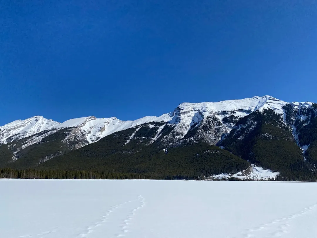
The Sunshine Coast Trail (SCT) is British Columbia's longest trail, a rugged and remote 180-kilometre journey that winds through coastal rainforest, along rugged shorelines, and over challenging mountain passes. Stretching from the village of Lund in the north to the community of Sechelt in the south, this trail offers an unparalleled opportunity to experience the wild beauty of the Sunshine Coast. It's a true wilderness experience, demanding self-sufficiency, careful planning, and a spirit of adventure. The SCT is not a manicured path; it's a true backcountry trail that tests your resilience and rewards you with breathtaking vistas, abundant wildlife, and a profound sense of accomplishment.
- Distance: 180.0 km one-way
- Duration: 8–12 days
- Season: April to October (best conditions)
- Difficulty: Challenging
- Elevation Gain: 6300 m
- Closest City: Powell River
- Trailhead Access: Nearest airport: Vancouver (YVR). Take a BC Ferries to Powell River. From Powell River, drive north on Hwy 101 to Lund (northern terminus) or south to Sarah Point (southern terminus). Parking available at both termini. Road conditions generally good. Check BC Ferries schedules. No permits needed for hiking, but registration recommended at trailheads.
- Coordinates: 49.7019, -124.0207
Overview
The Sunshine Coast Trail is a testament to the untamed spirit of British Columbia's coastal wilderness. Unlike many well-trodden paths, the SCT is a true expedition, a multi-day trek that immerses you in a diverse range of ecosystems. You'll traverse ancient temperate rainforests, where moss-draped cedars and firs create a cathedral-like canopy, and emerge onto exposed headlands offering panoramic views of the Salish Sea and its surrounding islands. The trail is a mosaic of challenging ascents and descents, often involving steep, rugged terrain, muddy sections, and stream crossings. It's a journey that requires a high level of fitness, navigation skills, and preparedness.
The trail is divided into distinct sections, each offering its own unique character. From the northern end, you begin near the picturesque village of Lund, a historic gateway to the coast. As you head south, the landscape gradually shifts, from the dense forests of the northern Sunshine Coast to the more exposed, rocky terrain closer to the southern end. You'll encounter pristine lakes, cascading waterfalls, and the constant presence of the ocean, its tides shaping the shoreline and influencing the coastal environment. Wildlife sightings are common, including deer, black bears, eagles, and various marine life if you're near the coast.
The SCT is a trail for those seeking a genuine backcountry experience. It's a place where you can disconnect from the demands of modern life and reconnect with the raw power of nature. The remoteness of sections of the trail means you'll often find yourself alone, surrounded only by the sounds of the forest and the sea. This solitude, combined with the physical challenge, makes completing the Sunshine Coast Trail a deeply rewarding achievement.
History and Cultural Context
The Sunshine Coast Trail's history is deeply intertwined with the Indigenous peoples who have inhabited this land for millennia. The Tla'amin Nation (formerly Sliammon First Nation) and the shíshálh Nation (Sechelt Indian Band) have ancestral ties to the lands traversed by the trail. Their traditional territories encompass the diverse ecosystems, waterways, and coastlines that the SCT now follows. For thousands of years, these lands provided sustenance, shelter, and spiritual connection. Traditional routes, often following waterways and coastal areas, were used for hunting, fishing, gathering, and trade. The modern trail often overlaps with or runs parallel to these ancient pathways, a reminder of the enduring human presence in this region.
The development of the Sunshine Coast Trail as a modern hiking route began in the late 20th century, driven by the vision of local enthusiasts and the Powell River Parks and Wilderness Society (PRWS). The goal was to create a long-distance trail that showcased the unique natural beauty of the Sunshine Coast and provided a challenging, multi-day hiking experience. The trail was built and maintained primarily by volunteers, a testament to the community's dedication to preserving and promoting this wild landscape. Over the years, the PRWS has worked tirelessly to clear, mark, and maintain the trail, often in challenging terrain and remote locations. This volunteer effort has been crucial in making the SCT accessible to hikers.
The trail's route has evolved over time, with sections being rerouted or improved to enhance safety and the hiking experience. The establishment of huts and shelters along the way has also been a significant development, providing essential refuge for multi-day hikers. The Sunshine Coast Trail represents a modern endeavour to connect people with the natural environment, built upon a foundation of ancient human history and sustained by the passion of a dedicated community.
Seasonal Highlights and Weather Reality
The Sunshine Coast Trail experiences distinct seasonal variations, each offering a different perspective on this dynamic coastal environment. The primary hiking season runs from April to October, when the weather is generally more favourable for trekking.
Spring (April to May): This is an excellent time to hike the SCT, especially the lower elevations. Snowmelt begins, and the forests start to awaken with vibrant green foliage. Wildflowers begin to bloom, and wildlife becomes more active. However, higher elevations may still hold snow, particularly in shaded areas or on north-facing slopes, potentially making some sections challenging or impassable without appropriate gear. Rivers and streams can be high due to snowmelt, requiring careful crossing.
Summer (June to August): Summer offers the most stable weather, with longer daylight hours and generally warmer temperatures. This is the peak season for many hikers. However, it can also be the busiest time, and sandflies can be prevalent, especially in damp, forested areas. Coastal fog is also common, particularly in the mornings, which can obscure views but also adds a mystical atmosphere to the rainforest. Temperatures can vary significantly between the coast and higher inland sections.
Autumn (September to October): Autumn is a spectacular time to hike the SCT. The deciduous trees in the rainforest turn brilliant shades of gold and red, creating a stunning visual display. The air is crisp, and the insect population typically diminishes. The weather can be more unpredictable, with increased chances of rain and cooler temperatures, especially at higher elevations. Early snowfalls are possible in late October.
Winter (November to March): The SCT is generally not recommended for hiking during the winter months. Heavy snowfall at higher elevations can make the trail impassable and dangerous. Many huts may be inaccessible or unmaintained. Coastal areas can experience significant rainfall and strong winds. Winter hiking on the SCT requires advanced backcountry and winter mountaineering skills, appropriate equipment, and thorough knowledge of avalanche conditions.
Weather Considerations: The Sunshine Coast's weather is heavily influenced by the Pacific Ocean. Expect rain at any time of year, often in the form of persistent drizzle or heavy downpours. Coastal fog is common, especially in the mornings and evenings. Temperatures can fluctuate significantly with elevation and proximity to the coast. Always be prepared for a wide range of conditions, including wind, rain, and cooler temperatures, even in summer.
Recommended Itinerary
10-Day Sunshine Coast Trail Itinerary (Sample)
This is a sample itinerary and can be adjusted based on fitness, pace, and desired side trips. Distances and times are approximate.
Day 1: Lund to Lois Lake Hut
- Distance: 15 km
- Elevation gain: 400 m
- Time: 5–7 hours
- Start at the historic village of Lund
- Follow logging roads and then singletrack trail through coastal forest
- Pass through areas of old-growth forest
- Arrive at Lois Lake Hut
- This section offers a gentle introduction to the trail's character
Day 2: Lois Lake Hut to Powell Lake Hut
- Distance: 18 km
- Elevation gain: 550 m
- Time: 6–8 hours
- Continue through dense rainforest
- Sections of muddy trail and stream crossings
- Ascend to viewpoints overlooking Powell Lake
- Arrive at Powell Lake Hut
- A more challenging day with significant elevation changes
Day 3: Powell Lake Hut to Goat Lake Hut
- Distance: 20 km
- Elevation gain: 700 m
- Time: 7–9 hours
- Follow the shores of Powell Lake for a section
- Climb into more rugged, mountainous terrain
- Pass through alpine meadows (seasonal)
- Arrive at Goat Lake Hut, situated near a beautiful alpine lake
- This day marks a transition into higher, more exposed terrain
Day 4: Goat Lake Hut to grey Creek Hut
- Distance: 16 km
- Elevation gain: 600 m
- Time: 6–8 hours
- Descend from Goat Lake towards grey Creek
- Trail can be steep and rocky in places
- Cross grey Creek (potential for challenging crossings depending on water levels)
- Arrive at grey Creek Hut
- A day of significant descent and potential water challenges
Day 5: grey Creek Hut to Rainy Lake Hut
- Distance: 14 km
- Elevation gain: 450 m
- Time: 5–7 hours
- Follow the grey Creek valley
- Trail conditions can be variable, including muddy sections
- Arrive at Rainy Lake Hut, located near a serene lake
- A moderate day focusing on valley travel
Day 6: Rainy Lake Hut to Skookumchuck Hut
- Distance: 22 km
- Elevation gain: 500 m
- Time: 7–9 hours
- Longer day with varied terrain
- Pass through different forest types
- Potential for wildlife sightings
- Arrive at Skookumchuck Hut
- A substantial day requiring good stamina
Day 7: Skookumchuck Hut to Halfway Log Hut
- Distance: 18 km
- Elevation gain: 400 m
- Time: 6–8 hours
- Continue through coastal forests
- Sections of shoreline walking possible
- Arrive at Halfway Log Hut
- A day of steady progress through varied coastal landscapes
Day 8: Halfway Log Hut to Dakota Ridge Hut
- Distance: 17 km
- Elevation gain: 750 m
- Time: 7–9 hours
- Significant climb towards Dakota Ridge
- Exposed ridge walking with panoramic views (weather permitting)
- Arrive at Dakota Ridge Hut
- A challenging day with a substantial climb and potential for stunning views
Day 9: Dakota Ridge Hut to Lang Bay Hut
- Distance: 15 km
- Elevation gain: 300 m
- Time: 5–7 hours
- Descend from Dakota Ridge towards Lang Bay
- Trail can be steep and rocky
- Pass through coastal forest
- Arrive at Lang Bay Hut
- A day of descent and transition back towards coastal communities
Day 10: Lang Bay Hut to Sechelt
- Distance: 10 km
- Elevation gain: 200 m
- Time: 3–4 hours
- Final section of the trail
- Easy walking towards the community of Sechelt
- Trail ends near Sechelt, with access to amenities and transportation
- Celebratory end to a challenging trek
Important Notes:
- Huts are first-come, first-served and not reservable. Bring a tent as a backup.
- Water sources are generally plentiful but should be treated.
- Trail conditions can vary significantly; be prepared for mud, steep sections, and stream crossings.
- Navigation skills are essential, especially in foggy or wet conditions.
- Carry a map, compass, and GPS device.
- Inform someone of your itinerary and expected return date.
Planning and Bookings
Book Your Trip
Everything you need to plan your journey
Accommodation
Find places to stay near Powell River
Flights
Search flights to Powell River
Essential Preparation
The Sunshine Coast Trail is a serious undertaking that requires meticulous planning. Due to its remote nature and the lack of regular resupply points, hikers must be entirely self-sufficient. This means carrying all necessary food, shelter, and safety equipment for the duration of the trek. Thorough research into trail conditions, weather forecasts, and potential hazards is paramount. Given the trail's length and challenging terrain, a high level of physical fitness is essential. Hikers should be comfortable carrying a heavy pack for extended periods over varied and often difficult terrain. It is also highly recommended to inform a reliable contact of your detailed itinerary, including your expected start and end dates, and to check in with them upon completion of your hike. The closest major city with an international airport is Vancouver (YVR). From Vancouver, you will need to take a BC Ferries service to Powell River (on the north end) or to Langdale (closer to the south end, requiring a bus connection to Sechelt). From Powell River, you can drive north on Highway 101 to the northern trailhead at Lund. From Sechelt, you can access the southern terminus. Road conditions to the trailheads are generally good, but it's always wise to check for any advisories before travelling.
Trail Accommodation
The Sunshine Coast Trail features a network of backcountry huts and shelters maintained by the Powell River Parks and Wilderness Society (PRWS). These structures offer basic refuge from the elements but are not luxurious accommodations. They are typically simple, open-plan shelters with wooden bunks and a roof. Some may have a wood stove, but fuel is not guaranteed. There are no reservations for these huts; they operate on a first-come, first-served basis. Hikers should always carry a tent and sleeping bag as a backup, as huts can be full, especially during peak season.
Hut Facilities:
- Basic wooden bunks (bring your own sleeping bag)
- Shelter from rain and wind
- Some huts may have a wood stove (bring your own fire starter and be aware of fire bans)
- Outdoor pit toilets (carry your own toilet paper and trowel for emergencies)
What Huts Don't Provide:
- Food or cooking supplies
- Sleeping bags, pillows, or bedding
- Cooking equipment (pots, pans, utensils)
- Water treatment facilities (always treat water from natural sources)
- Electricity or charging facilities
- Heating (unless a wood stove is present and functional)
- Regular maintenance or cleaning services
Booking Requirements:
- No bookings are required or accepted for huts.
- Hikers must be prepared to camp if huts are full.
- There are no designated campsites; choose durable surfaces away from water sources.
- Costs: While the huts are generally free to use, donations to the Powell River Parks and Wilderness Society are highly encouraged to support trail maintenance.
Seasonal Availability: Huts are generally accessible year-round, but snow can make access difficult or impossible during winter months. Spring and autumn can bring challenging weather conditions that make hut use more critical.
Required Gear
- Backpack (60-80 litres): A sturdy, comfortable pack capable of carrying all your gear for an extended period.
- Tent: A lightweight, durable tent is essential as a backup for huts.
- Sleeping bag: Rated for temperatures down to 0°C or lower, as nights can be cool.
- Sleeping pad: For insulation and comfort.
- Waterproof and windproof jacket and trousers: Essential for the unpredictable coastal weather.
- Insulating layers: Fleece or down jacket, thermal base layers.
- Hiking boots: Sturdy, waterproof, and well broken-in boots with good ankle support.
- Camp shoes or sandals: For use around camp and at huts.
- Navigation tools: Map of the Sunshine Coast Trail, compass, and a GPS device or smartphone with offline maps.
- Headlamp or flashlight: With extra batteries.
- First-aid kit: Comprehensive kit including blister treatment, pain relievers, bandages, antiseptic wipes, and any personal medications.
- Sun protection: Sunscreen, sunglasses, and a wide-brimmed hat.
- Insect repellent: Especially important during summer months for sandflies and mosquitoes.
- Trekking poles: Highly recommended for stability on steep and uneven terrain.
- Knife or multi-tool.
- Water bottles or hydration reservoir (minimum 3-litre capacity).
- Water filter or purification tablets.
What to Bring
- Food: Sufficient non-perishable food for the entire duration of your hike, plus extra for emergencies. Plan meals carefully to balance nutrition and weight.
- Cooking stove and fuel: A reliable backpacking stove and enough fuel.
- Cookware: Lightweight pot, mug, bowl, and eating utensils.
- Toiletries: Biodegradable soap, toothbrush, toothpaste, toilet paper, hand sanitiser, small trowel for digging catholes if away from pit toilets.
- Trash bags: To pack out all your waste.
- Repair kit: Duct tape, cordage, safety pins, needle and thread for gear repairs.
- Whistle: For signalling in emergencies.
- Personal items: Camera, book, journal, identification, cash for emergencies or potential ferry fares.
- Bear spray: Recommended for personal safety in bear country. Know how to use it.
- Dry bags: To keep essential gear dry inside your backpack.
Permits
Currently, no permits are required to hike the Sunshine Coast Trail. The trail is managed by the Powell River Parks and Wilderness Society (PRWS) with support from local government and volunteer efforts. However, it is always advisable to check the official PRWS website or local tourism information for any updates or changes to regulations before your trip. While no permits are needed for hiking, registration at trailheads is recommended. This helps authorities track who is on the trail and can be crucial in case of an emergency. Many hikers choose to leave their itinerary with a trusted friend or family member, which serves a similar purpose.
Registration:
- It is highly recommended to register your hike at the trailhead information boards located at both the northern (Lund) and southern (Sechelt) termini.
- Record your name, contact information, expected start and end dates, and your intended route.
- This information is invaluable for search and rescue operations if needed.
Hut Usage:
- As mentioned, huts are first-come, first-served. There is no fee to use the huts, but donations to the PRWS are greatly appreciated to help fund trail maintenance and improvements.
- If huts are full, hikers are expected to camp in designated areas or on durable surfaces away from water sources, following Leave No Trace principles.
Parking:
- Parking is available at both the Lund and Sechelt trailheads. It is advisable to secure your vehicle appropriately and be aware of any local parking regulations or fees.
- Consider leaving a note on your dashboard with your expected return date.
BC Ferries:
- If you are travelling from Vancouver, you will need to book BC Ferries. It is recommended to check ferry schedules and book in advance, especially during peak travel times.
- Ferry fares apply for both passengers and vehicles.
Other Activities in the Area
The Sunshine Coast offers a wealth of activities beyond the trail itself, allowing for a richer and more varied experience:
- Kayaking and Canoeing: Explore the numerous lakes and coastal inlets. Powell Lake and the surrounding waters are particularly popular for paddling.
- Fishing: The region is renowned for its excellent fishing opportunities, both in freshwater lakes and the ocean.
- Wildlife Viewing: Keep an eye out for whales, dolphins, seals, sea lions, eagles, and various land mammals like deer and black bears. Boat tours can offer excellent opportunities for marine wildlife spotting.
- Exploring Coastal Communities: Visit charming towns like Lund, Powell River, and Sechelt. Enjoy local shops, restaurants, and learn about the area's history and culture.
- Beachcombing: The rugged coastline offers many opportunities to explore beaches, discover driftwood, and enjoy the ocean air.
- Scuba Diving: The waters around the Sunshine Coast are known for their clear visibility and diverse marine life, making it a popular destination for divers.
- Hiking shorter trails: Numerous day hikes and shorter multi-day trails exist throughout the Sunshine Coast, offering different perspectives of the landscape.
- Visiting Local Art Galleries and Studios: The Sunshine Coast is home to a vibrant arts community, with many local artists showcasing their work.
Safety and Conditions
Trail Conditions: The Sunshine Coast Trail is a challenging wilderness route. Trail conditions can vary significantly due to weather, season, and maintenance levels. Expect muddy sections, overgrown areas, steep and rocky ascents and descents, and numerous stream crossings. Some crossings may be hazardous, especially after heavy rain or during spring snowmelt. Always assess water levels and flow before attempting a crossing.
Weather: Coastal weather is notoriously unpredictable. Be prepared for rain, wind, fog, and temperature fluctuations at any time of year. Hypothermia is a risk, even in summer, especially at higher elevations or during prolonged wet conditions. Always carry adequate rain gear and warm layers.
Wildlife: The Sunshine Coast is home to black bears, cougars, and other wildlife. It is crucial to be bear-aware. Carry bear spray and know how to use it. Store food properly in bear-resistant containers or hang it securely away from your campsite. Make noise while hiking to avoid surprising animals. Never feed wildlife.
Navigation: While the trail is marked, it is not always extensively signed. Navigation skills are essential. Carry a detailed map, compass, and GPS device, and know how to use them. Fog can reduce visibility significantly, making navigation more difficult.
Water: Water sources are generally available along the trail, but all water should be treated (filtered, boiled, or chemically purified) before consumption to prevent waterborne illnesses.
Communication: Cell phone reception is unreliable and often non-existent along large sections of the trail. Consider carrying a satellite communication device (e.g., satellite messenger or personal locator beacon) for emergencies.
Emergency Preparedness: Inform someone of your detailed itinerary and expected return date. Carry a comprehensive first-aid kit and know how to use it. Be prepared to self-rescue or wait for assistance if necessary.
Physical Fitness: The SCT is a demanding hike. Ensure you are physically fit and have trained adequately for carrying a heavy pack over challenging terrain for multiple days.
Side Trips and Points of Interest
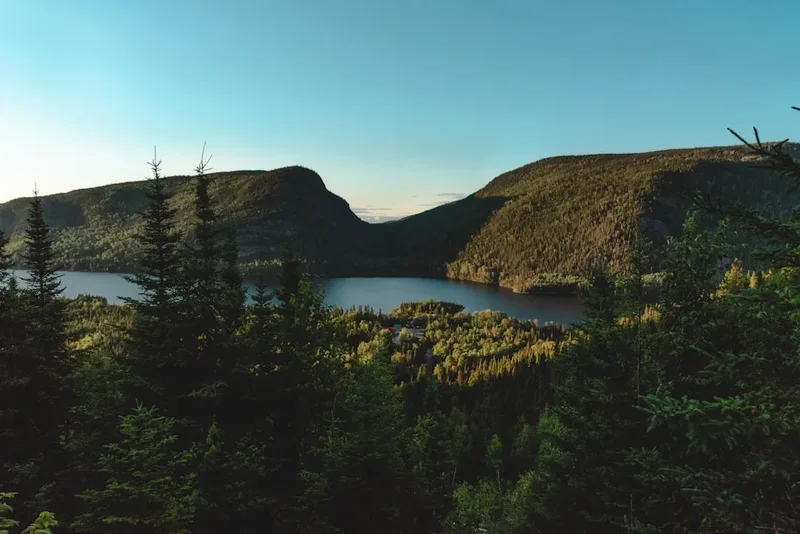
Powell Lake: A significant feature of the trail, Powell Lake is a large, glacially-carved lake that the SCT follows for a considerable distance. Its stunning turquoise waters and surrounding rugged mountains offer beautiful scenery and opportunities for reflection. Sections of the trail run along its shores.
Goat Lake: Located at a higher elevation, Goat Lake is a picturesque alpine lake that provides a scenic backdrop and a potential camping spot. The area around Goat Lake offers a different landscape from the coastal rainforest, with more open terrain and mountain views.
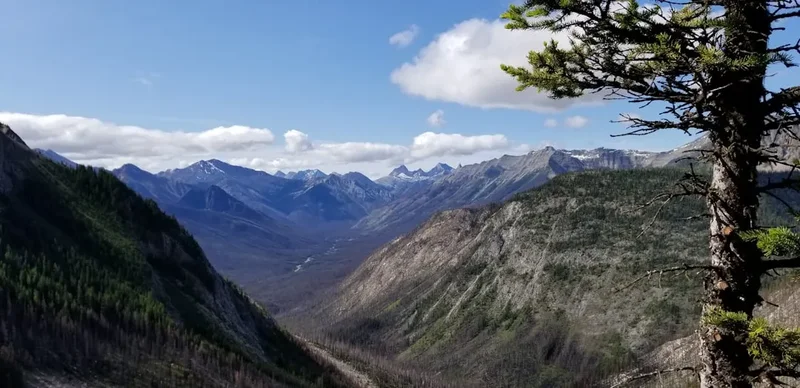
Dakota Ridge: This section of the trail offers expansive views of the surrounding mountains and coastal inlets. In clear weather, the vistas from Dakota Ridge are spectacular, providing a sense of the vastness of the Sunshine Coast wilderness.
Lund Village: The northern terminus of the trail, Lund is a historic and charming village. It's a great place to start or end your hike, offering amenities and a sense of the coastal lifestyle. The historic Lund Hotel is a notable landmark.
Sechelt: The southern terminus, Sechelt is a larger community with more services. It provides a convenient point for resupply, accommodation, and transportation after completing the trail.
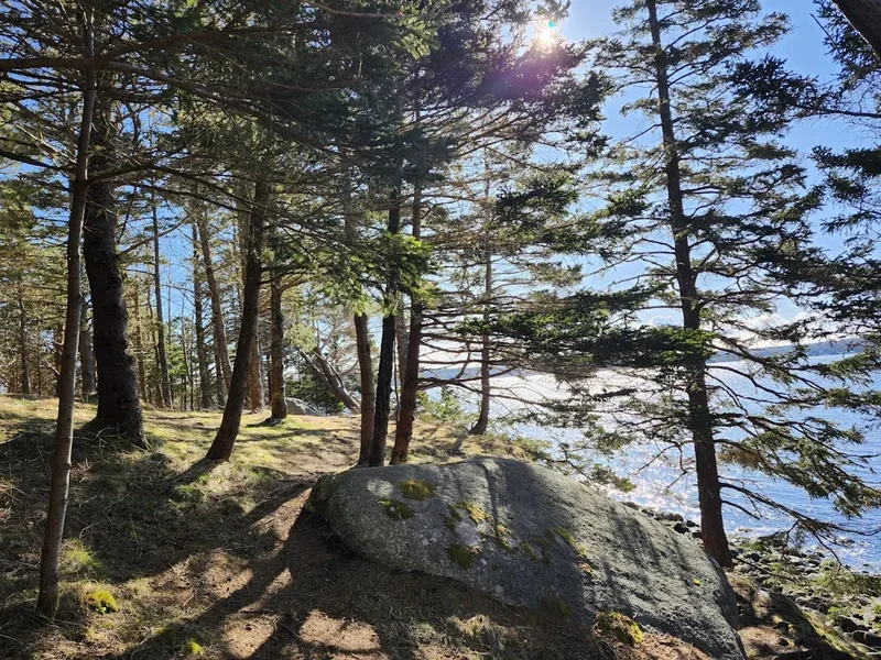
Old-Growth Forests: The SCT passes through magnificent stands of old-growth temperate rainforest, featuring towering cedars, firs, and hemlocks draped in moss. These ancient forests are a highlight of the trail, offering a sense of awe and timelessness.
Leave No Trace
The Sunshine Coast Trail traverses a sensitive and wild environment. Adhering to Leave No Trace principles is crucial for preserving its natural beauty and ensuring a positive experience for future hikers. The trail is maintained largely by volunteers, and respecting the environment helps reduce the burden on these efforts.
Plan Ahead and Prepare: Research the trail thoroughly, know your capabilities, and be prepared for all conditions. Pack appropriate gear and sufficient food. Inform someone of your plans.
Travel and Camp on Durable Surfaces: Stick to the marked trail to avoid damaging vegetation. When camping, use established sites or choose durable surfaces like rock, gravel, or dry grass, at least 70 metres away from water sources.
Dispose of Waste Properly: Pack out everything you pack in, including all food scraps, wrappers, and toilet paper. Use designated pit toilets where available. If no toilet is available, dig a cathole 15-20 cm deep at least 70 metres from water, camp, and trails. Pack out all toilet paper.
Leave What You Find: Do not remove or disturb natural objects, cultural artifacts, or plants. Leave them for others to enjoy.
Minimize Campfire Impacts: Use a lightweight stove for cooking. If a campfire is permitted and necessary, use existing fire rings and keep fires small. Ensure fires are completely extinguished before leaving.
Respect Wildlife: Observe wildlife from a distance. Never feed animals, as it can harm their health, alter their natural behaviours, and put you at risk. Store food securely.
Be Considerate of Other Visitors: Yield to other hikers, especially those going uphill. Keep noise levels down to enjoy the natural sounds of the wilderness. Respect the solitude of others.
Useful Links
- Sunshine Coast Trail Official Website (Powell River Parks and Wilderness Society)
- Powell River Parks and Recreation - Sunshine Coast Trail Information
- BC Ferries
- DriveBC - Road Conditions
- BC Parks - Skookumchuck Provincial Park (near trail section)
- BC Parks - Smelters Bay Provincial Park (near trail section)