
Calimani Volcano Trail - A Journey to Romania's Volcanic Heart
The Calimani Volcano Trail, also known as the "11 Lakes Trail" or "Tihuța Pass Trail," is a captivating day walk located in the Calimani Mountains of Romania. This route offers a unique opportunity to explore a dormant volcanic caldera, traverse alpine meadows dotted with glacial lakes, and witness breathtaking panoramic views. The trail is renowned for its diverse landscapes, ranging from dense coniferous forests to open, windswept plateaus, making it a rewarding experience for hikers seeking natural beauty and geological wonders. The journey culminates at the impressive crater lake, Iezerul Calimani, a testament to the region's fiery past.
- Distance: 10.5 km (one-way to crater lake and back)
- Duration: 5-7 hours (round trip)
- Season: June to September (summer and early autumn)
- Elevation Gain: 750 m
- Difficulty: Moderate
- Trailhead Access: Accessible by car, approximately 20 km from Vatra Dornei
- Closest City: Vatra Dornei
- Coordinates: 47.3333, 25.2833
Overview
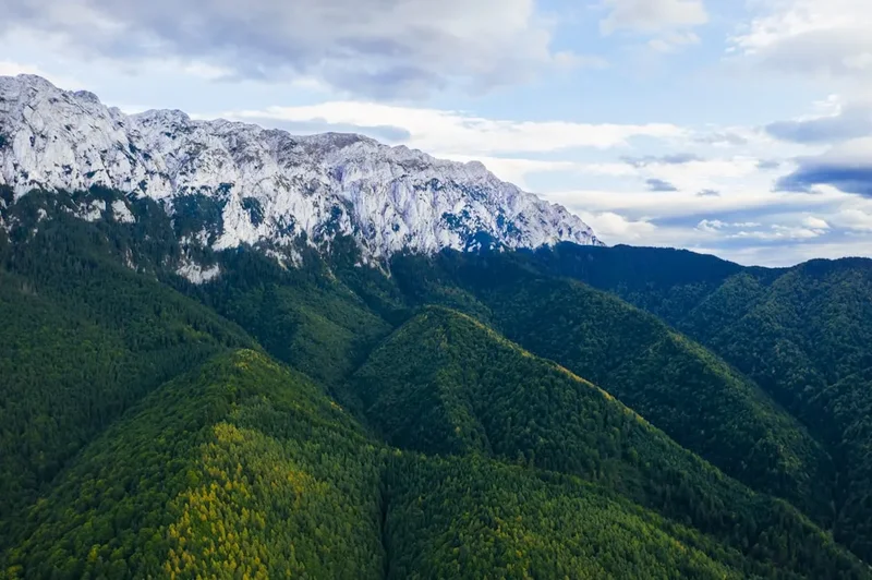
The Calimani Volcano Trail is a moderate day hike that ascends into the heart of the Calimani Mountains, a range known for its volcanic origins. The trail begins in a forested area, gradually climbing through mixed woodlands before emerging into alpine meadows. As the elevation increases, the landscape opens up, revealing sweeping vistas of the surrounding peaks and valleys. The highlight of the hike is reaching the caldera of the Calimani Volcano, a vast, ancient crater that now cradles a series of stunning glacial lakes, the most prominent being Iezerul Calimani.
The trail is well-marked for the most part, though some sections can be steep and rocky, requiring a reasonable level of fitness. The ascent is steady, allowing hikers to acclimatise to the altitude. Along the way, you'll encounter diverse flora and fauna, with wildflowers blooming profusely in the summer months. The air is crisp and clean, and the sense of remoteness is palpable. The final approach to the crater rim offers spectacular views, and the sight of the deep blue Iezerul Calimani lake nestled within the volcanic bowl is a truly memorable reward.
This trail is particularly appealing for its geological significance. The Calimani Mountains are the remnants of a large stratovolcano that was active millions of years ago. The erosion of this ancient volcano has sculpted the dramatic landscape, creating the unique features seen today. The presence of glacial lakes, formed in the depressions left by volcanic activity and subsequent glaciation, adds to the area's natural charm. While the volcano is dormant, the evidence of its power is etched into the very fabric of the mountains.
History and Geological Significance
The Calimani Mountains are a testament to Romania's volcanic past. Geologically, they form part of the Călimani-Gurghiu range, a chain of extinct volcanoes that were active during the Neogene period, primarily between 10 and 5 million years ago. The Calimani massif itself is the largest volcanic structure in the Romanian Carpathians, with its highest peak, Vârful Pietrosul Călimanilor (2,102 m), being the highest point in the range. The formation of this massive stratovolcano involved numerous eruptions, lava flows, and pyroclastic events, shaping the distinctive topography that hikers experience today.
The trail's route often follows paths that have historically been used by shepherds and local communities for accessing high-altitude pastures and resources. While not as extensively documented as some other European trails, the Calimani Volcano Trail is part of a network of routes that connect various points of interest within the Calimani National Park. The park was established to protect the unique geological formations, diverse ecosystems, and rich biodiversity of the region.
The "11 Lakes Trail" moniker hints at the numerous glacial lakes that dot the caldera and surrounding slopes. These lakes, including the prominent Iezerul Calimani, were formed by glacial erosion and subsequent filling of depressions. The presence of these pristine alpine lakes, set against the backdrop of volcanic rock and alpine meadows, creates a landscape of exceptional natural beauty. The area has also been a subject of scientific interest, particularly for its geological formations and the unique flora and fauna that have adapted to the volcanic soil and alpine climate.
Seasonal Highlights and Weather Considerations
The best time to hike the Calimani Volcano Trail is during the summer months, from June to September. During this period, the weather is generally more stable, and the snow has melted from the higher elevations, making the trails accessible and safe.
Summer (June to August): This is peak season for hiking in the Calimani Mountains. The alpine meadows are in full bloom, creating a vibrant tapestry of colours. The days are long, offering ample time for hiking and enjoying the scenery. However, summer can also bring afternoon thunderstorms, which are common in mountainous regions. Hikers should be prepared for sudden changes in weather, including rain, wind, and cooler temperatures, especially at higher altitudes.
Early Autumn (September): September offers a beautiful transition period. The crowds of summer have thinned, and the autumn colours begin to appear in the forests, adding a golden hue to the landscape. The weather can still be pleasant, with crisp, clear days, but the risk of early snow increases towards the end of the month. Temperatures will be cooler, and frost is possible at night.
Late Autumn and Winter (October to May): These months are generally not recommended for hiking the Calimani Volcano Trail. Heavy snowfall can make the trails impassable and dangerous. The volcanic caldera and higher elevations can be covered in deep snow, and avalanche risk is a serious concern. Access to the trailhead may also be difficult due to snow-covered roads.
Weather Variability: Mountain weather is notoriously unpredictable. Even during the summer, temperatures can drop significantly, and conditions can change rapidly. It is crucial to check the weather forecast before setting out and to be prepared for all eventualities with appropriate clothing and gear.
Recommended Itinerary

Calimani Volcano Trail - Day Hike Itinerary
Early Morning (Approx. 8:00 AM): Departure from Vatra Dornei
- Begin your journey from Vatra Dornei.
- Drive towards the Tihuța Pass (Pasul Tihuța), following signs for the Calimani Mountains.
- The trailhead is located approximately 20 km from Vatra Dornei, often near the area of the Tihuța Pass or a designated parking area.
- Ensure you have a full tank of fuel and any necessary supplies.
Morning (Approx. 9:00 AM - 10:00 AM): Trailhead and Initial Ascent
- Arrive at the trailhead and prepare for your hike.
- Begin the ascent into the coniferous forest.
- The initial part of the trail is generally well-marked and involves a steady climb through dense woodland.
- Enjoy the cool, shaded environment and the sounds of the forest.
Late Morning (Approx. 11:00 AM - 1:00 PM): Transition to Alpine Meadows
- The forest begins to thin as you gain elevation.
- You will start to emerge into open alpine meadows.
- The landscape opens up, offering the first glimpses of the surrounding mountain ranges.
- Keep an eye out for wildflowers, especially during the summer months.
- The trail may become steeper and rockier in sections.
Midday (Approx. 1:00 PM - 2:30 PM): Reaching the Caldera Rim and Lake Iezerul Calimani
- Continue your ascent towards the volcanic caldera.
- The trail leads you to the rim of the ancient volcano.
- The first sight of Iezerul Calimani, the largest glacial lake within the caldera, is a spectacular moment.
- Take time to admire the panoramic views of the crater and the surrounding mountains.
- This is an ideal spot for a picnic lunch and to rest.
Afternoon (Approx. 2:30 PM - 4:00 PM): Exploration and Descent Preparation
- Explore the immediate vicinity of the lake and the caldera rim.
- Note the unique geological formations and the stark beauty of the volcanic landscape.
- Begin your descent back towards the trailhead.
- The descent will follow the same path as the ascent.
Late Afternoon (Approx. 4:00 PM - 6:00 PM): Return to Trailhead and Departure
- Continue your descent through the alpine meadows and back into the forest.
- Arrive back at the trailhead.
- Begin your drive back to Vatra Dornei.
Important Notes:
- This is a day hike, and no overnight accommodation is required on the trail itself.
- The trail is marked, but carrying a map and compass or GPS device is recommended.
- Be prepared for changing weather conditions.
- Carry sufficient water and food for the entire duration of the hike.
- Respect the natural environment and follow Leave No Trace principles.
Planning and Bookings
Book Your Trip
Everything you need to plan your journey
Accommodation
Find places to stay near Vatra Dornei
Flights
Search flights to Vatra Dornei
Essential Preparation
The Calimani Volcano Trail is a day hike, meaning no complex booking coordination for accommodation is required. However, essential preparation focuses on logistics, fitness, and understanding the trail's demands. The closest major town and logistical hub is Vatra Dornei, which offers a range of accommodation options from guesthouses to hotels, as well as essential services like supermarkets, pharmacies, and outdoor equipment shops. Ensure your vehicle is in good condition for the drive to the trailhead, as some access roads may be unpaved or rough. A moderate level of fitness is required due to the significant elevation gain over a relatively short distance. Familiarise yourself with the trail's route using maps or GPS devices, as while generally marked, remote sections can be challenging.
Trail Accommodation
This is a day hike requiring no overnight accommodation. Hikers typically base themselves in Vatra Dornei or nearby villages and complete the trail within a single day.
Required Gear
- Sturdy hiking boots: Waterproof and with good ankle support are essential for the rocky and uneven terrain.
- Backpack: A daypack (20-30 litres) to carry essentials.
- Waterproof and windproof jacket: Mountain weather can change rapidly; be prepared for rain and wind.
- Warm layers: Fleece or synthetic mid-layers are recommended, as temperatures can be significantly cooler at higher altitudes.
- Navigation tools: A map of the Calimani Mountains, a compass, and/or a GPS device or smartphone with offline maps.
- First-aid kit: Including blister treatment, bandages, antiseptic wipes, pain relievers, and any personal medications.
- Sun protection: Sunscreen (SPF 30+), sunglasses, and a wide-brimmed hat or cap, as the sun can be intense at higher elevations.
- Head torch: With spare batteries, in case of unexpected delays or early starts/late finishes.
What to Bring
- Sufficient water: At least 1.5-2 litres per person, as water sources on the trail may be unreliable or require treatment.
- Food and snacks: High-energy snacks, sandwiches, and a packed lunch. There are no facilities for purchasing food on the trail.
- Water treatment method: If you plan to refill water from natural sources, carry a water filter or purification tablets.
- Insect repellent: Especially important during summer months to ward off flies and mosquitoes.
- Trekking poles: Optional, but can be very helpful for steep ascents and descents, reducing strain on knees.
- Camera: To capture the stunning volcanic landscapes and alpine scenery.
- Personal items: Mobile phone (note that signal may be intermittent), power bank, hand sanitiser, and toilet paper.
Permits
No specific permits are required for hiking the Calimani Volcano Trail. The trail is located within the Calimani National Park, and while there are no entry fees or booking systems for day hikers, it is always advisable to check for any local regulations or advisories issued by the park authorities. Information can typically be found through Romanian national park services or local tourism offices.
Park Regulations: While no permits are needed, visitors are expected to adhere to the rules of the national park, which generally include:
- Staying on marked trails to protect the fragile alpine environment.
- Not disturbing wildlife or removing plants.
- Proper disposal of waste (pack it in, pack it out).
- Avoiding campfires outside designated areas (though this is a day hike, so camping is not applicable).
Best Practice: It is good practice to inform someone of your hiking plans, including your intended route and estimated return time, especially when hiking in remote areas.
Other Activities in the Area
The region surrounding the Calimani Mountains and Vatra Dornei offers several other attractions and activities for visitors:
- Vatra Dornei: Explore the spa town of Vatra Dornei, known for its mineral springs and sanatoriums. You can enjoy a relaxing spa treatment or a walk through the town's parks.
- Skiing: In winter, Vatra Dornei is a popular ski resort with several slopes suitable for various skill levels.
- Hiking in other parts of Calimani National Park: The park offers numerous other trails, including routes to other peaks, waterfalls, and geological formations.
- Traditional villages: Explore nearby traditional Romanian villages to experience local culture, architecture, and cuisine.
- Rarău Mountains: A short drive from Vatra Dornei, the Rarău Mountains offer dramatic rock formations like the "Lady's Rocks" (Pietrele Doamnei) and hiking opportunities.
- Danube Delta (further afield): For a more extensive trip, the Danube Delta, a UNESCO World Heritage site, offers unique biodiversity and boat tours, though it requires significant travel time from Vatra Dornei.
Safety and Conditions
Trail Conditions: The Calimani Volcano Trail is generally well-marked, but conditions can vary. The path can be steep, rocky, and uneven, especially as you approach the caldera. In wet weather, sections can become slippery and muddy. Snow can persist on higher ground well into early summer, and early snowfalls can occur in autumn.
Weather: Mountain weather is highly unpredictable. Be prepared for rapid changes, including sudden rain, strong winds, fog, and significant temperature drops, even on a sunny day. Always check the weather forecast before you go and be ready to turn back if conditions deteriorate.
Altitude: The trail reaches significant altitudes, and while it is a day hike, acclimatisation is still a factor. Be aware of the symptoms of altitude sickness, such as headache, nausea, and dizziness. If you experience these, descend to a lower altitude.
Wildlife: While large predators like bears are present in the Romanian Carpathians, encounters on well-trafficked trails are rare. However, it is always wise to be aware of your surroundings. Smaller wildlife, such as marmots and various bird species, are common. Insects, particularly flies and mosquitoes, can be prevalent in summer; carry effective repellent.
Navigation: While the main trail is marked, it is essential to carry a map and compass or a GPS device. Do not rely solely on mobile phone signal, as it can be intermittent in mountainous areas. Inform someone of your hiking plans, including your expected return time.
Emergency: In case of an emergency, try to contact local mountain rescue services or emergency numbers. Mobile phone reception may be limited, so consider carrying a personal locator beacon (PLB) if hiking in very remote areas or during off-peak seasons.
Hydration and Nutrition: Carry ample water and high-energy food. Dehydration and low blood sugar can lead to fatigue and poor decision-making, increasing the risk of accidents.
Side Trips and Points of Interest
Iezerul Calimani (Crater Lake): The primary point of interest and the culmination of the hike. This large, stunning glacial lake sits within the ancient volcanic caldera. Its deep blue waters and the surrounding rugged terrain create a dramatic and memorable scene. It's an ideal spot for photography and a well-deserved rest.
Other Glacial Lakes: While Iezerul Calimani is the most prominent, the caldera and surrounding slopes are dotted with smaller glacial lakes, often referred to collectively as the "11 Lakes." Depending on the exact route and time available, some of these smaller lakes can be visited as short detours from the main path, offering further opportunities to appreciate the unique alpine environment.
Volcanic Formations: The entire area is a showcase of volcanic geology. As you ascend, observe the rock types, the layering of ancient lava flows, and the erosional features that have shaped the landscape over millennia. The caldera rim itself is a significant geological feature.
Alpine Meadows and Flora: During the summer months, the alpine meadows are carpeted with a variety of wildflowers. These vibrant displays add colour and life to the rugged landscape. Keep an eye out for endemic species and enjoy the natural beauty.
Panoramic Viewpoints: Numerous points along the trail, especially as you gain elevation and reach the caldera rim, offer spectacular panoramic views of the Calimani Mountains, the surrounding valleys, and on clear days, distant peaks. These viewpoints are perfect for appreciating the scale and grandeur of the landscape.
Leave No Trace
The Calimani Volcano Trail traverses a sensitive natural environment within the Calimani National Park. Adhering to Leave No Trace principles is crucial to preserving its beauty and ecological integrity for future visitors and for the health of the ecosystem.
Plan Ahead and Prepare: Understand the trail's conditions, weather, and any specific regulations before you go. Pack appropriately to avoid needing to improvise or leave waste behind.
Travel and Camp on Durable Surfaces: Stick to marked trails. Avoid walking on fragile vegetation, especially in alpine meadows where plants are slow to recover. The trail itself is the designated durable surface.
Dispose of Waste Properly: Pack out everything you pack in. This includes all food scraps, wrappers, and any other litter. Use designated bins if available at the trailhead, but assume you will need to carry all waste back with you.
Leave What You Find: Do not take rocks, plants, or any other natural objects. Leave them for others to enjoy and for the ecosystem to thrive.
Minimize Campfire Impacts: This is a day hike, so campfires are not applicable. However, if you were to camp in designated areas (not on this trail), use established fire rings and keep fires small.
Respect Wildlife: Observe wildlife from a distance. Never feed animals, as this can disrupt their natural behaviours and diets. Store food securely to prevent attracting animals.
Be Considerate of Other Visitors: Keep noise levels down, especially in natural settings. Yield to other hikers on narrow sections of the trail. Respect the peaceful nature of the environment.