Sugarloaf Mountain Trail - The Gateway to Rio’s Atlantic Forest
The Sugarloaf Mountain Trail, known locally as the Trilha do Morro da Urca, is one of Rio de Janeiro’s most accessible yet rewarding outdoor experiences. While millions of tourists ascend the iconic Pão de Açúcar (Sugarloaf Mountain) via the world-famous cable car system, the more adventurous choose to traverse the lush, emerald slopes of the Morro da Urca on foot. This 2.3-kilometre journey serves as a profound introduction to the Mata Atlântica (Atlantic Forest), a biodiversity hotspot that once covered the entire Brazilian coastline. Rising from the golden sands of Praia Vermelha, the trail winds through dense tropical canopies, offering glimpses of marmosets, exotic birdlife, and the shimmering turquoise waters of Guanabara Bay. It is a walk that bridges the gap between the urban sprawl of one of the world’s most vibrant cities and the ancient, rugged geology of the Brazilian Highlands. For those seeking to earn their view of the "Marvellous City," this trail provides a physical and spiritual connection to the landscape that defines Rio’s identity.
- Distance: 2.3 km return (or one-way with cable car descent)
- Duration: 0.5–1 hour (ascent only)
- Season: Year-round (best from April to October)
- Difficulty: Easy to Moderate (steep sections but well-maintained)
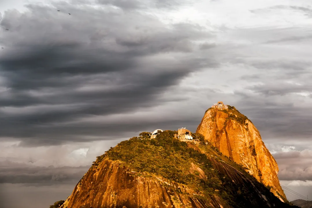
- Highest point: Morro da Urca (220 m)
- Trailhead: Pista Cláudio Coutinho, Praia Vermelha, Urca
- Access: Free entry to the trail; tickets required for the second stage of the cable car
Overview
The Sugarloaf Mountain Trail is more than just a shortcut to a viewpoint; it is a sensory immersion into the heart of Rio de Janeiro’s natural heritage. The trail is situated within the Monumento Natural dos Morros do Pão de Açúcar e da Urca, a protected area established to preserve the unique geological formations and the remaining fragments of the Atlantic Forest. The route begins at the Pista Cláudio Coutinho, a paved seaside path popular with local joggers and fishers, before veering sharply into the forest. The transition is immediate: the sound of crashing waves is replaced by the rhythmic hum of cicadas and the rustle of wind through palm fronds.
The ascent is relatively short but involves a steady incline over a mix of dirt paths, stone steps, and exposed tree roots. Despite its proximity to the city, the trail feels remarkably wild. The canopy overhead provides a welcome respite from the intense Brazilian sun, creating a microclimate that is often several degrees cooler than the surrounding streets. Along the way, hikers are frequently greeted by the "Mico-estrela" (black-tufted marmoset), small, inquisitive primates that have become the unofficial mascots of the trail. While their presence is a delight, they serve as a reminder of the delicate balance between urban expansion and wildlife preservation.
Upon reaching the summit of Morro da Urca (the first of the two peaks in the Sugarloaf complex), the forest opens up to reveal a sprawling 360-degree panorama. To the south lies the vast Atlantic Ocean; to the west, the iconic silhouette of Christ the Redeemer atop Corcovado Mountain; and to the north, the bustling downtown centre and the Rio-Niterói Bridge. The Morro da Urca serves as the middle station for the cable car system, offering facilities such as cafés, shops, and an amphitheatre. From here, hikers can choose to purchase a ticket to continue to the higher Pão de Açúcar peak via cable car, or simply soak in the views before descending back through the forest. This trail is the perfect introduction for those new to hiking in the tropics, offering high rewards for a relatively modest physical investment.
History and Cultural Context
The history of the Sugarloaf Mountain complex is inextricably linked to the founding of Rio de Janeiro. The name "Pão de Açúcar" was coined by the Portuguese in the 16th century. During the height of the sugar cane trade, sugar was boiled and placed in conical clay moulds called "sugar loaves" to be transported. The shape of the granite peak rising from the bay bore a striking resemblance to these moulds, and the name has persisted for over 400 years. However, long before the Europeans arrived, the indigenous Tupi-Guarani people called the peak "Pau-nh-Açu," which translates to "High Hill" or "Isolated Peak" in their native tongue.
Geologically, the mountains are part of a family of granite and gneiss monoliths that rise directly from the water’s edge. These formations are among the oldest in the world, dating back over 600 million years to the Neoproterozoic era. They are the remnants of a massive mountain range that existed when the supercontinent Gondwana was still intact. The sheer vertical walls of the Sugarloaf have made it a world-class destination for rock climbing, with the first recorded ascent of the main peak occurring in 1817 by an Englishwoman named Henrietta Carstairs.
The cultural significance of the Morro da Urca trail evolved significantly in the 20th century. In 1912, the first aerial cable car in Brazil (and only the third in the world) was inaugurated, connecting Praia Vermelha to Morro da Urca and then to Pão de Açúcar. This engineering marvel transformed the peaks from formidable obstacles into global tourist icons. The trail itself was originally used by military personnel and early explorers, but it was eventually formalised and opened to the public as part of the city’s efforts to promote eco-tourism. Today, the trail is a symbol of Rio’s "Carioca" lifestyle—a blend of urban sophistication and a deep-seated love for the outdoors. It is a place where locals come to exercise before work and where visitors come to find a moment of peace amidst the city’s famous energy.
Want more background? Read extended notes on history and cultural context → Learn more
Seasonal Highlights and Weather Reality
Rio de Janeiro is a tropical city, meaning the Sugarloaf Mountain Trail is accessible year-round. However, the experience varies significantly depending on the season. The "best" time to hike is generally considered the dry season, which runs from April to October. During these months, the humidity is lower, and the temperatures are more manageable, typically ranging from 18°C to 26°C. The skies are often a brilliant, clear blue, providing the best visibility for photography and long-range views of the city.
Summer (December to March) brings a different set of challenges. Temperatures frequently soar above 35°C, and the humidity can make even a short hike feel strenuous. Afternoon thunderstorms are common; these "pancadas de chuva" are often intense but brief. If you are hiking in summer, it is essential to start as early as possible (the trail opens at 8:00 AM) to avoid the midday heat and the potential for lightning on the exposed summit. The forest canopy provides shade, but the air can feel heavy and still.
The shoulder seasons of spring (September to November) and autumn (March to May) offer a beautiful middle ground. In spring, the Atlantic Forest is in full bloom, and the scent of tropical flowers fills the air. This is also a fantastic time for birdwatching, as many species are more active during the breeding season. Regardless of the season, hikers should be aware of the "Veranico"—short periods of intense summer-like weather that can occur even in the middle of winter. Always check the local forecast for "chuva forte" (heavy rain), as the trail can become slippery and prone to minor mudslides after prolonged precipitation.
Recommended Itinerary
Sugarloaf Mountain (Morro da Urca) Day Hike
Early Morning: Arrival and Warm-up
- 08:00 AM: Arrive at Praia Vermelha in the Urca district. This is one of Rio's most picturesque and safest neighbourhoods.
- 08:15 AM: Begin walking along the Pista Cláudio Coutinho. This 1.25-km paved path hugs the base of the mountain and offers stunning views of the Atlantic.
- Look for the trailhead entrance on the left-hand side, approximately 300 metres from the start of the Pista Cláudio Coutinho. There is a clear signpost marking the "Trilha do Morro da Urca."
- Take a moment to check your water supply and ensure your footwear is secure before leaving the pavement.
Mid-Morning: The Ascent
- 08:30 AM: Enter the forest. The first section is the steepest, consisting of a series of zig-zags and stone steps designed to manage erosion.
- 08:45 AM: Reach the halfway point. The gradient levels out slightly, and the trail winds through denser forest. Keep an eye out for marmosets (Micos) in the trees.
- 09:00 AM: The final push. The trail emerges from the deep forest into a more scrub-like environment as you approach the plateau of Morro da Urca.
- 09:15 AM: Arrive at the summit of Morro da Urca (220 m). You will emerge near the cable car station and the helipad.
Late Morning: Summit Exploration
- Explore the various lookout points. The "Mirante" facing the Pão de Açúcar peak offers the most iconic photo opportunities.
- Visit the "Cocuruto" exhibition area, which details the history of the cable car and the geological formation of the peaks.
- Optional: Purchase a ticket at the station to take the second cable car up to the main Sugarloaf peak (Pão de Açúcar, 396 m). Note that you cannot buy a ticket to go down to the base from here unless you have already purchased a full ticket or use a digital payment method at the kiosks.
- Enjoy a fresh coconut water or a snack at one of the summit cafés while watching the planes take off from Santos Dumont Airport below.
Midday: The Return
- Option A: Hike back down the same trail. The descent is much faster (approx. 20 minutes) but requires care on the slippery sections.
- Option B: Take the cable car down to Praia Vermelha. (Note: This requires a paid ticket).
- 12:30 PM: Finish the hike back at Praia Vermelha. Reward yourself with a swim in the calm waters of the beach or a cold drink at one of the kiosks in Urca.
Important Notes:
- The trail officially closes for ascent at 16:00 (4:00 PM). Ensure you start well before this time.
- The path is well-marked, but stay on the main track to avoid damaging the undergrowth.
- Monkeys may approach you; do not feed them, as it disrupts their natural diet and can lead to aggressive behaviour.
- The trail can be crowded on weekends and public holidays; a weekday morning is the best time for solitude.
Planning and Bookings
Book Your Trip
Everything you need to plan your journey
Accommodation
Find places to stay near Rio de Janeiro
Flights
Search flights to Rio de Janeiro
Essential Preparation
The Sugarloaf Mountain Trail is a relatively low-commitment hike, but basic preparation is key to an enjoyable experience. No permits or advanced bookings are required to walk the trail itself. However, if you plan to use the cable car for any portion of your journey, it is highly recommended to purchase tickets online in advance to avoid long queues at the ticket office. The base town for this hike is the city of Rio de Janeiro, specifically the Urca neighbourhood. Urca is a quiet, residential, and military-influenced area, making it one of the safest places in the city for tourists.
Fitness requirements are modest; anyone with a basic level of walking fitness can complete the ascent. The main challenge is the humidity and the initial steepness. If you are not accustomed to tropical climates, allow extra time for breaks. Logistics are simple: the trailhead is easily reached by taxi, ride-sharing apps (Uber is very common in Rio), or public bus. There is limited parking at Praia Vermelha, so public transport or taxis are preferred.
Trail Accommodation
This is a day hike requiring no overnight accommodation. The trail is located entirely within the urban limits of Rio de Janeiro. Most hikers stay in the nearby neighbourhoods of Copacabana, Ipanema, or Botafogo, which are all within a 10-to-20-minute drive of the trailhead. There are no campsites or huts on the mountain. The summit of Morro da Urca features modern facilities, including toilets, restaurants, and shops, but these are only open during the operating hours of the cable car (typically 08:00 to 20:00).
Required Gear
- Footwear: Sturdy trainers with good grip are sufficient. Hiking boots are not strictly necessary but provide better ankle support on the root-filled sections. Avoid flip-flops or smooth-soled sandals.
- Clothing: Lightweight, moisture-wicking fabrics are essential. Rio’s humidity means cotton stays wet and becomes heavy. A hat and sunglasses are vital for the exposed summit.
- Navigation: The trail is very well-defined and signposted. A physical map is not necessary, but having a charged phone with an offline map (like Google Maps or AllTrails) is a good safety precaution.
- Safety Gear: A small personal first aid kit with plasters (band-aids) and antiseptic wipes.
What to Bring
- Water: At least 1.5 litres per person. While you can buy water at the top, the ascent is humid and you will need to hydrate along the way.
- Sun Protection: High SPF sunscreen (50+) is non-negotiable. The Brazilian sun is intense, even on overcast days.
- Insect Repellent: Essential for the forest sections, especially during the rainy season when mosquitoes are more active.
- Snacks: Energy bars, fruit, or nuts. There are restaurants at the top, but they can be expensive.
- Camera/Phone: For the spectacular views. A portable power bank is useful if you plan on taking many photos.
- Cash/Card: For the cable car ticket or refreshments at the summit. Most vendors in Rio accept international credit cards.
Permits
One of the greatest draws of the Sugarloaf Mountain Trail is that it is free to access. There are no entry fees, permits, or bureaucratic hurdles for hikers wishing to walk from the base to the Morro da Urca summit. The trail is managed by the Rio de Janeiro Municipal Secretariat for the Environment, and access is generally open from 08:00 to 16:00 for the ascent, and until 18:00 for the descent.
Cable Car Logistics:
- If you wish to continue from Morro da Urca to the higher Pão de Açúcar peak, you must purchase a ticket. This can be done at the ticket office on the Morro da Urca plateau.
- Prices for the cable car (Bondinho) vary. As of 2024, a full adult ticket for the entire circuit (Praia Vermelha - Morro da Urca - Pão de Açúcar and back) is approximately R$160–R$180. There are discounts for students, seniors, and children, provided you have valid identification.
- Important: In the past, hikers could take the cable car down for free after a certain hour. This is no longer the case. You must have a valid ticket to use the cable car for the descent. If you hike up and want to ride down, you will need to pay the "descent-only" or "partial" fare at the summit kiosks.
Group Access: Large organised groups or commercial tour operators may need to register with the park authorities, but for individual hikers and small groups of friends, no such requirement exists. Always check the official "Bondinho Pão de Açúcar" website for any temporary closures due to maintenance or private events, although the trail itself usually remains open even if the cable car is closed.
Other Activities in the Area
The Urca district and the surrounding coastline offer a wealth of activities that can be combined with your hike:
- Praia Vermelha (Red Beach): Located right at the trailhead, this small, sheltered beach is famous for its coarse, reddish sand and calm waters. It is a perfect spot for a post-hike swim or to rent a stand-up paddleboard.
- Pista Cláudio Coutinho: Even if you don't do the full hike, walking the length of this 1.25-km paved path is a must. It offers a unique perspective of the mountain's vertical granite walls, often dotted with rock climbers.
- Mureta da Urca: A local tradition. In the late afternoon, head to the low stone wall (mureta) along the harbour in Urca. Order a "empada" and a cold beer from Bar e Restaurante Urca and watch the sunset over the bay.
- Rock Climbing: The Sugarloaf complex is one of the largest urban climbing areas in the world. There are over 270 routes ranging from beginner slabs to expert vertical faces. Local guiding companies offer "intro to climbing" sessions on the Morro da Urca.
- Enseada de Botafogo: A short walk or taxi ride away, this bay offers the classic "postcard" view of Sugarloaf Mountain. It is a great spot for a scenic stroll or to visit the Rio Sul shopping centre for some air-conditioned relief.
Safety and Conditions
Environmental Hazards:
- Heat Exhaustion: This is the most common safety issue. The combination of high temperatures and humidity can lead to rapid dehydration. Drink water proactively, even if you don't feel thirsty.
- Slippery Terrain: The trail consists of decomposed granite and clay. After rain, it becomes incredibly slick. Wear shoes with deep tread and use extra caution on the descent.
- Wildlife: While the marmosets are cute, they are wild animals. Do not touch them, as they can bite or carry diseases. Be aware of the "Jararaca" (pit viper), which is native to the Atlantic Forest. While sightings on this busy trail are rare, always watch where you step and avoid sticking your hands into thick brush.
Personal Security:
- Urca is generally very safe, and the trail is well-trafficked by locals and tourists alike. However, as in any major city, exercise common sense. Do not carry excessive amounts of cash or wear expensive jewellery.
- Try to finish your hike well before sunset. The trail is not illuminated, and navigating the forest in the dark is dangerous due to the uneven terrain.
- There is a municipal guard presence at the entrance of Pista Cláudio Coutinho, which adds an extra layer of security.
Emergency Contacts:
- Fire Department/Ambulance (Bombeiros): 193
- Military Police: 190
- Tourist Police (DEAT): +55 21 2332-2924 (Located in Leblon, but handles tourist-related incidents city-wide).
Side Trips and Points of Interest
The "Secret" Lookout: About two-thirds of the way up the trail, there is a small, unofficial clearing to the right. It offers a framed view of Praia Vermelha and the military palaces below. It is a quieter spot for a photo than the main summit.
The Helipad: Once you reach the Morro da Urca, you will see a helipad. While you cannot walk on it, the area around it provides the best view of the cable cars as they glide between the two peaks. It is a fascinating study in 20th-century engineering.
Cocuruto: This is a small museum/exhibition space located on the Morro da Urca. It houses the original cable cars from 1912 and 1972. Seeing the tiny, wooden 1912 car makes you appreciate the bravery of early tourists and the incredible progress of Brazilian engineering.
Atlantic Forest Flora: Take a moment to look for the "Pau-Brasil" (Brazilwood) tree, which gave the country its name. You can also see massive Jackfruit trees (Jaqueiras). While the fruit is delicious, be careful—a falling jackfruit can weigh up to 30 kg and is a genuine hazard during the fruiting season!
Leave No Trace
The Sugarloaf Mountain Trail is located within a fragile urban ecosystem. With thousands of visitors each week, the cumulative impact can be devastating if Leave No Trace principles are not followed. The Atlantic Forest is one of the most threatened biomes on Earth, with only about 12% of its original cover remaining.
Guidelines for Responsible Hiking:
- Carry Out All Trash: There are bins at the trailhead and at the summit, but none along the trail itself. If you bring a snack, ensure every piece of plastic or organic waste (like banana peels) is carried out. Organic waste can attract invasive species and disrupt the local fauna's diet.
- Do Not Feed the Wildlife: This is the most frequently broken rule. Feeding marmosets makes them dependent on humans and can make them aggressive. It also exposes them to human bacteria that can be fatal to small primates.
- Stay on the Path: Cutting corners on the zig-zags causes severe soil erosion, especially during Rio's heavy rains. This can eventually lead to trail closures and damage to the mountain's root systems.
- Respect the Silence: Many people hike this trail to escape the noise of the city. Avoid using speakers or shouting. Let the sounds of the forest prevail.
- No Smoking: The leaf litter in the Atlantic Forest can be highly flammable during the dry season. Smoking is prohibited on the trail to prevent forest fires.