South West Coast Path - England's Ultimate Coastal Odyssey
The South West Coast Path (SWCP) is the longest of England's National Trails, stretching a formidable 1,014 kilometres from the Somerset town of Minehead to the shores of Poole Harbour in Dorset. This is not merely a walk; it is a monumental journey through some of the most diverse and dramatic maritime landscapes in Europe. Traversing the entire coastlines of Devon and Cornwall, as well as parts of Somerset and Dorset, the path offers an immersive experience into the geological history of the Earth, from the ancient red sandstones of Exmoor to the Jurassic fossils of the eastern reaches. With a total elevation gain of approximately 35,000 metres—equivalent to climbing Mount Everest nearly four times—the SWCP is a world-class thru-hiking challenge that tests the endurance of even the most seasoned walkers while rewarding them with unparalleled coastal vistas, hidden coves, and historic fishing villages.
- Distance: 1,014 km one-way
- Duration: 8–10 weeks (for a full thru-hike)
- Season: May to September (best weather; accessible year-round for experienced walkers)
- Accommodation: B&Bs, campsites, hostels, and local inns
- Highest point: Great Hangman, Devon (244 m)
- Total Elevation Gain: 35,000 m
- Difficulty: Challenging (due to length and constant ascent/descent)
- Direction: Traditionally walked westwards/southwards from Minehead to Poole
Overview
The South West Coast Path is a masterclass in coastal topography. It follows the undulating edge of the Atlantic Ocean and the English Channel, providing a front-row seat to the raw power of the sea. The trail is characterised by its "rollercoaster" nature; walkers rarely find a flat stretch of path for long. Instead, the route consists of a relentless series of steep descents into wooded "mouths" or "combes" followed by immediate, lung-busting climbs back onto the cliff tops. This constant change in elevation is what gives the path its legendary difficulty rating, far exceeding what the modest maximum height of 244 metres might suggest.
The journey is divided into several distinct geographical regions, each with its own unique character. The North Devon and Somerset section features the highest cliffs in England, where the moorland of Exmoor meets the sea in a dramatic wall of rock. Moving into North Cornwall, the landscape becomes more rugged and exposed, with jagged slate cliffs and world-famous surfing beaches like Bude and Newquay. The far west of Cornwall, around Land's End and the Lizard Peninsula, offers a wild, granite-hewn landscape where the Atlantic swell is at its most ferocious. The South Coast of Cornwall and Devon provides a softer, more sheltered environment with deep-water estuaries, subtropical gardens, and historic naval ports like Plymouth and Dartmouth. Finally, the trail concludes along the Jurassic Coast in Dorset, a UNESCO World Heritage site where 185 million years of geological history are exposed in the crumbling limestone and chalk cliffs.
Walking the SWCP is as much a cultural journey as a physical one. The path passes through dozens of quintessential English villages where life has revolved around the sea for centuries. From the narrow, cobbled streets of Clovelly to the artistic enclave of St Ives and the bustling harbour of Brixham, the trail connects the dots of England's maritime heritage. Whether you are seeking the solitude of a remote cliff-top or the warmth of a traditional pub at the end of a long day, the South West Coast Path delivers an experience that is both humbling and deeply life-affirming.
History and Cultural Context
The origins of the South West Coast Path are rooted in the necessity of law enforcement rather than recreation. Much of the current route was originally created by the Coastguard to facilitate the patrolling of the shoreline to catch smugglers. In the 18th and 19th centuries, smuggling was a major industry in the South West, with tea, brandy, and silk being brought ashore in remote coves to avoid heavy government taxes. The Coastguards needed a path that followed the very edge of the cliffs, providing a clear view into every hidden bay and inlet. This explains why the path often hugs the cliff edge so closely, even when a more direct route inland might have been easier to construct.
As the threat of smuggling diminished, the paths remained, used by local fishermen and villagers. It wasn't until the mid-20th century that the idea of a continuous long-distance trail for walkers began to take shape. The South West Coast Path was officially designated as a National Trail in 1978, though it took many more years to negotiate access and link all the various sections together. Today, the path is managed by the South West Coast Path Association in partnership with the National Trust, Natural England, and local authorities.
The cultural impact of the path is immense. It has inspired countless artists, writers, and poets. From the "Wessex" of Thomas Hardy in Dorset to the haunting landscapes of Daphne du Maurier in Cornwall, the coast has long been a muse for the British creative imagination. The path also passes through areas of significant industrial heritage, including the Cornish Mining World Heritage site, where the iconic engine houses of tin and copper mines still stand as sentinels on the cliffs, reminding walkers of the region's hardworking past.
Want more background? Read extended notes on history and cultural context → Learn more
Seasonal Highlights and Weather Reality
The South West of England enjoys a maritime climate, which means it is generally milder than the rest of the UK, but also significantly wetter and windier. The weather can change with startling speed; a morning of brilliant sunshine can easily transition into a misty afternoon with horizontal rain and gale-force winds.
Spring (March to May): This is arguably the most beautiful time to walk. The cliff tops are carpeted in wildflowers, including sea pinks (thrift), gorse, and bluebells. Birdlife is at its most active, with puffins, razorbills, and guillemots returning to the cliffs to breed. The weather is often crisp and clear, though the ground can still be muddy from winter rains.
Summer (June to August): The most popular time for walking. The days are long, with twilight lasting until nearly 10:00 PM in June. The sea is at its warmest for those brave enough to swim, and all seasonal ferries and amenities are fully operational. However, the path can be crowded in popular areas, and accommodation must be booked months in advance. Heatwaves can occur, making the steep climbs particularly taxing.
Autumn (September to November): September is often the "golden month," offering settled weather, fewer crowds, and warm seas. As autumn progresses, the landscape turns to shades of ochre and gold. This is a prime time for spotting grey seals and their pups in the secluded coves of North Cornwall and Devon. However, the risk of Atlantic storms increases significantly from October onwards.
Winter (December to February): Only recommended for experienced, well-equipped walkers. The path can be extremely muddy and slippery, and short daylight hours limit the distance that can be covered. Many seasonal ferries and cafes close during this period. However, for those who enjoy the raw power of the ocean, winter storm-watching on the SWCP is a spectacular experience.
Recommended Itinerary
8-Week South West Coast Path Thru-Hike Itinerary
Week 1: Minehead to Westward Ho! (The Exmoor & North Devon Coast)
- Distance: ~125 km
- Key Waypoints: Porlock Weir, Lynton & Lynmouth, Valley of Rocks, Combe Martin, Ilfracombe, Woolacombe, Croyde
- Highlights: The highest cliffs in England at Great Hangman; the unique water-powered cliff railway at Lynton; the vast golden sands of Woolacombe Beach
- Terrain: Very strenuous with significant climbs and descents through wooded combes
Week 2: Westward Ho! to Padstow (The Rugged North Coast)
- Distance: ~130 km
- Key Waypoints: Clovelly, Hartland Quay, Bude, Boscastle, Tintagel, Port Isaac
- Highlights: The cobbled, car-free village of Clovelly; the dramatic, folded strata of Hartland Quay (the toughest section of the path); the legendary Tintagel Castle, linked to King Arthur
- Terrain: Extremely rugged and exposed; Hartland to Bude is considered the most demanding section of the entire 1,014 km
Week 3: Padstow to St Ives (The Surfing Coast)
- Distance: ~110 km
- Key Waypoints: Trevose Head, Mawgan Porth, Newquay, Perranporth, St Agnes, Portreath, Hayle
- Highlights: The "Seven Bays" near Padstow; the surfing mecca of Newquay; the iconic engine houses at Wheal Coates near St Agnes
- Terrain: Moderate to strenuous; long sandy beaches provide some flatter walking, but cliff sections remain undulating
Week 4: St Ives to Falmouth (The Far West & The Lizard)
- Distance: ~135 km
- Key Waypoints: Zennor, Land's End, Porthcurno, Mousehole, Penzance, Marazion (St Michael's Mount), Porthleven, The Lizard, Coverack
- Highlights: The wild granite landscape of West Penwith; the Minack Theatre carved into the cliff; the southernmost point of mainland Britain at The Lizard; the tidal island of St Michael's Mount
- Terrain: Strenuous and rocky around Zennor; flatter around Mount's Bay; rugged again around the Lizard Peninsula
Week 5: Falmouth to Plymouth (South Cornwall's Hidden Coast)
- Distance: ~120 km
- Key Waypoints: St Mawes, Portloe, Mevagissey, Fowey, Polperro, Looe, Kingsand & Cawsand
- Highlights: Multiple ferry crossings (Falmouth, Fowey); the picturesque fishing village of Polperro; the historic naval heritage of Plymouth Sound
- Terrain: Moderate; many estuaries require ferry coordination or long inland detours if ferries are not running
Week 6: Plymouth to Exmouth (The South Devon Riviera)
- Distance: ~130 km
- Key Waypoints: Wembury, Bigbury-on-Sea, Salcombe, Dartmouth, Brixham, Torquay, Teignmouth, Dawlish
- Highlights: Crossing the River Yealm; the stunning estuary at Salcombe; the historic port of Dartmouth; the red sandstone cliffs of Dawlish
- Terrain: Strenuous around the South Hams; more urban and flatter through the "English Riviera" towns of Torbay
Week 7: Exmouth to Weymouth (The Western Jurassic Coast)
- Distance: ~125 km
- Key Waypoints: Budleigh Salterton, Sidmouth, Beer, Seaton, Lyme Regis, Charmouth, West Bay, Abbotsbury
- Highlights: The Triassic red cliffs of Sidmouth; fossil hunting at Lyme Regis and Charmouth; the towering golden cliffs of West Bay (Broadchurch filming location); the 29 km long shingle bank of Chesil Beach
- Terrain: Strenuous; the Undercliff between Seaton and Lyme Regis is a unique, jungle-like wilderness area
Week 8: Weymouth to Poole (The Eastern Jurassic Coast)
- Distance: ~139 km (including the Isle of Portland loop)
- Key Waypoints: Isle of Portland, Lulworth Cove, Durdle Door, Kimmeridge, Worth Matravers, Swanage, Old Harry Rocks, South Haven Point
- Highlights: The limestone arch of Durdle Door; the perfect circular bay of Lulworth Cove; the chalk stacks of Old Harry Rocks; the official finish marker at South Haven Point
- Terrain: Strenuous; the section through the Lulworth Ranges features some of the steepest, albeit short, climbs on the entire path
Important Notes:
- Ferry crossings are a vital part of the SWCP. Always check seasonal timetables, as some only operate from April to October.
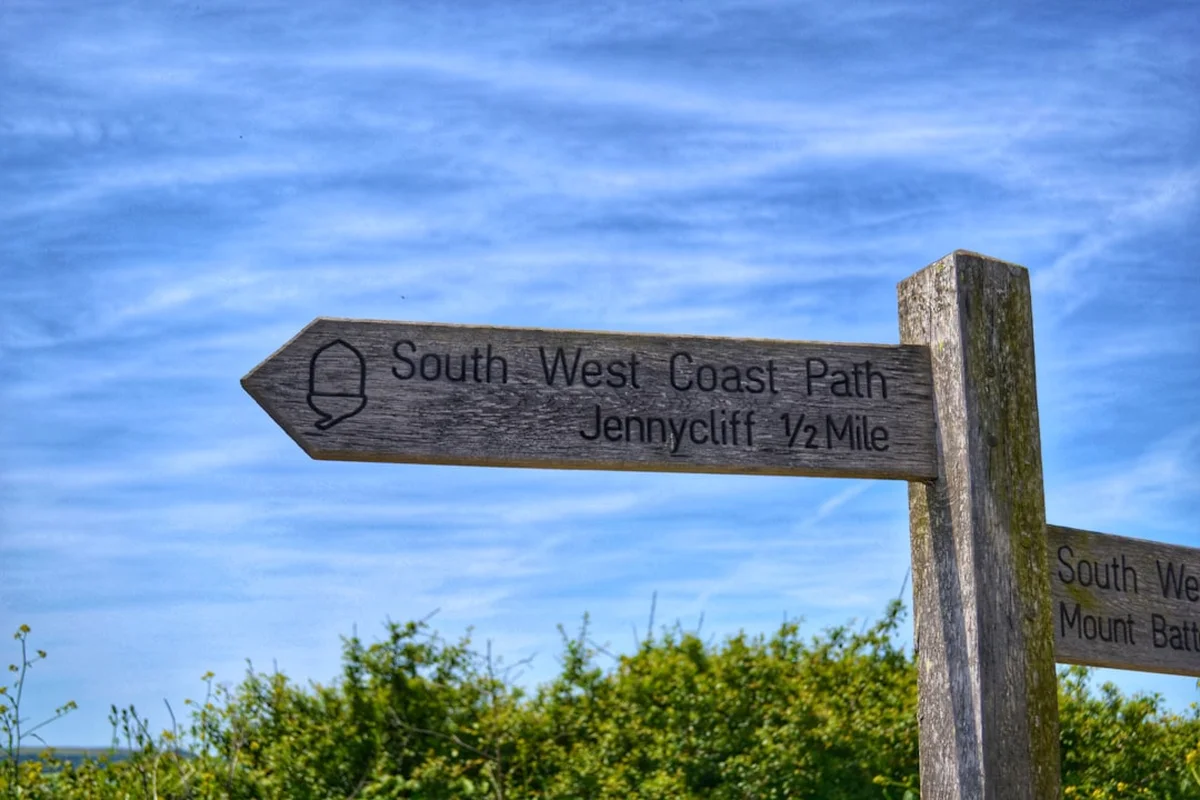
- The path is marked with an acorn symbol, the hallmark of UK National Trails.
- Tide times are critical for certain beach crossings and estuary fords (e.g., the Erme and Yealm in South Devon).
- The total distance of 1,014 km includes the Isle of Portland loop, which many thru-hikers choose to include.
Planning and Bookings
Book Your Trip
Everything you need to plan your journey
Accommodation
Find places to stay near Exeter
Flights
Search flights to Exeter
Essential Preparation
Planning a full thru-hike of the South West Coast Path requires significant logistical coordination. Unlike many mountain trails, the SWCP passes through or near towns almost daily, meaning you do not need to carry weeks of food. However, the sheer length of the trail means that physical preparation is paramount. You should be comfortable walking 20–25 kilometres per day with a loaded pack over hilly terrain. Training should focus on repetitive ascent and descent to condition the knees and calves.
Logistically, you must decide whether to walk the path in one go or in sections. For a thru-hike, Minehead is the traditional starting point, accessible via train to Taunton and then a bus (No. 28). The finish at South Haven Point is a short ferry ride from Sandbanks, which has bus links to Bournemouth and Poole railway stations. If you are not carrying your own gear, several luggage transfer services operate along the entire length of the path, moving your bags from one accommodation to the next for a fee.
Trail Accommodation
The South West Coast Path offers a wide variety of accommodation, but availability varies significantly by region and season. Because the path is a National Trail and not a wilderness route, there are no "huts" in the alpine sense. Instead, walkers rely on commercial accommodation.
Accommodation Types:
- Bed & Breakfasts (B&Bs) and Inns: The most common choice. They provide a bed, a hot shower, and a substantial breakfast. Costs typically range from £70 to £120 per night for a double room.
- Campsites: Plentiful in summer, especially in Cornwall and Devon. Many are geared towards families and caravans, but most have space for "backpacking tents." Costs are usually £10 to £20 per night.
- Youth Hostels (YHA): There are several YHAs located directly on or very near the path (e.g., Minehead, Penzance, Beer). These offer the most budget-friendly indoor accommodation.
- Wild Camping: In England, wild camping is technically illegal without the landowner's permission (except in parts of Dartmoor, which the path does not cross). However, it is often tolerated if you pitch late, leave early, and stay well away from residential areas and livestock.
Booking Requirements: During July and August, booking accommodation weeks or even months in advance is essential. In the shoulder seasons, you may have more flexibility, but popular villages like Clovelly, St Ives, and Padstow always fill up quickly.
Required Gear
- Footwear: High-quality, waterproof hiking boots with good ankle support are recommended for the rugged sections. Some walkers prefer trail runners for the flatter Dorset sections, but the mud of North Devon usually demands boots.
- Waterproofs: A high-spec waterproof jacket and overtrousers are non-negotiable. The South West is prone to heavy Atlantic rain and sea spray.
- Backpack: 50–65L for thru-hikers carrying camping gear; 25–35L for those using luggage transfers. A waterproof rain cover is essential.
- Navigation: While the path is well-marked with acorn signs, a dedicated guidebook (like the South West Coast Path Association's official guide) or GPS mapping (OS Maps app) is vital for navigating through towns and finding accommodation detours.
- Trekking Poles: Highly recommended to save your knees during the 35,000 metres of total descent.
- Gaiters: Very useful in the shoulder seasons to protect against mud and wet grass.
What to Bring
- Water Treatment: While you can often refill at cafes or pubs, a lightweight filter or purification tablets are useful for long stretches between villages.
- Sun Protection: The coastal sun is deceptively strong due to the reflection off the water. Bring SPF 30+ sun cream, a hat, and sunglasses.
- First Aid: Focus on blister care (Compeed, zinc oxide tape), antiseptic cream, and ibuprofen for muscle aches.
- Power Bank: Essential for keeping your phone/GPS charged, especially if camping.
- Clothing Layers: Merino wool base layers are excellent for moisture management. Bring a lightweight fleece or down jacket for chilly evenings on the cliffs.
- Swimwear: You will pass hundreds of tempting beaches; a lightweight travel towel and swimwear are worth the weight.
- Cash: While most places take cards, some small ferries and remote honesty stalls (selling cakes or fruit) still require cash.
Permits
One of the great advantages of the South West Coast Path is that no permits or fees are required to walk the trail itself. As a National Trail, it is a public right of way, open to everyone at no cost. However, there are several logistical "costs of entry" that walkers must plan for.
Ferry Costs: The path crosses numerous rivers and estuaries. While some have bridges, many rely on small passenger ferries. These typically cost between £3 and £10 per crossing. Key ferries include the Karrek Dhu (Padstow), the King Harry Ferry (River Fal), the Dartmouth Lower Ferry, and the Sandbanks Ferry (Poole). Most operate seasonally (April to October), so winter walkers must plan for significant inland detours.
Lulworth Ranges: A section of the path in Dorset passes through the Lulworth Ranges, a military firing range. This section is only open at weekends and during major public holidays. If the range is closed, a long inland detour is required. Always check the "Lulworth Ranges firing times" online before reaching Weymouth.
National Trust Parking: If you are doing day hikes and driving to trailheads, parking can be expensive. Many coastal car parks are owned by the National Trust. Membership (£80–£90 per year) provides free parking at these sites and is often more cost-effective than paying daily fees for a multi-week trip.
Other Activities in the Area
The South West is England's premier holiday destination, offering a wealth of activities to complement your walk:
- Surfing: North Devon and North Cornwall offer world-class surf. Croyde, Saunton Sands, Bude, and Newquay are the top spots for both beginners and pros.
- Fossil Hunting: The beaches of Lyme Regis and Charmouth on the Jurassic Coast are famous for ammonites and ichthyosaur remains. Guided fossil walks are highly recommended.
- The Eden Project: Located near St Austell, these massive biomes house the world's largest indoor rainforest and are a short detour from the path.
- Minack Theatre: An open-air theatre carved into the granite cliffs at Porthcurno. Watching a play here with the Atlantic as a backdrop is a bucket-list experience.
- St Michael's Mount: A medieval castle and church perched on a tidal island near Penzance. Accessible by a stone causeway at low tide or a small boat at high tide.
- Sea Kayaking and Coasteering: For a different perspective of the cliffs, many operators in places like Swanage, Salcombe, and St Ives offer guided water-based adventures.
- Vineyard and Brewery Tours: The South West has a burgeoning wine industry (e.g., Camel Valley) and a long tradition of cider making and craft brewing.
Safety and Conditions
Cliff Safety: The most significant danger on the SWCP is the cliff edge. Coastal erosion is a constant process, and cliff falls can occur at any time, especially after heavy rain. Always stay on the marked path, never climb over fences, and keep dogs on short leads. Do not stand near the edge to take photographs, as the ground can be undercut and unstable.
Tides: Several sections of the path involve crossing beaches or tidal estuaries. The River Erme and River Yealm in South Devon are famous for requiring low-tide crossings (wading). Attempting these at high tide is dangerous. Always carry a tide table or check the "tide times" for the local area daily.
Weather and Exposure: On the high, exposed cliffs of North Devon and Cornwall, wind speeds can be significantly higher than inland. In gale-force winds, it is safer to take an inland route. Heat exhaustion is also a risk in summer, as there is very little shade on the cliff tops. Carry at least 2 litres of water per person.
Livestock: The path frequently passes through fields with cattle and sheep. Always close gates behind you. If walking with a dog, keep it under close control. If cattle approach you aggressively, let your dog off the lead so it can run away, and move calmly to the nearest exit.
Emergency Services: In an emergency, dial 999 or 112 and ask for the Coastguard. Because mobile signal can be patchy in remote coves, it is wise to tell someone your planned route and expected arrival time each day.
Side Trips and Points of Interest
Lundy Island: Located 19 km off the North Devon coast, Lundy is a granite outcrop famous for its puffins, seals, and unique flora. A day trip via the MS Oldenburg from Ilfracombe or Bideford is a fantastic addition to the Week 1 itinerary.
Tintagel Castle: While the path passes right by it, taking 2–3 hours to explore the ruins and the spectacular new footbridge is essential. The site is managed by English Heritage and offers incredible views of the "Island" and Merlin's Cave below.
The Lizard Wireless Station: Located at Bass Point, this is where Guglielmo Marconi conducted his pioneering radio experiments. It is a fascinating stop for those interested in the history of technology.
Chapman's Pool: A remote and beautiful cove in Dorset, accessible via a steep side path from the main trail. It is much quieter than Lulworth Cove and offers a sense of true coastal isolation.
The South West Coast Path Markers: Look out for the various "halfway" and "finish" markers. The official halfway point is at Reach Brake, near Porthallow in Cornwall, marked by a large stone monument. The finish at South Haven Point features a beautiful bronze sculpture of the path's various landscapes.
Leave No Trace
The South West Coast Path passes through numerous Sites of Special Scientific Interest (SSSI), National Parks, and Areas of Outstanding Natural Beauty (AONB). The ecosystem of the maritime turf and cliff-top heathland is extremely fragile and easily damaged by foot traffic and litter.
Your responsibility as a walker:
- Stick to the Path: Avoid taking shortcuts, especially on steep slopes, as this causes erosion and damages rare plants like the early gentian or wild asparagus.
- Litter: Pack out everything you bring in. This includes fruit peels and nut shells, which can take years to decompose in the salty coastal air and can harm local wildlife.
- Human Waste: Use public toilets in villages whenever possible. If you must go on the trail, ensure you are at least 50 metres from the path and any water sources, and bury waste deep in a hole. Carry out all toilet paper and sanitary products.
- Wildlife: Observe seals and nesting birds from a distance. Using binoculars is better than getting close and causing distress, which can lead to birds abandoning their nests or seals injuring themselves while rushing into the sea.
- Fire: Never light fires or disposable BBQs on the path or beaches. Wildfires are a significant risk to the dry coastal heathland.