South Sister Summit - Oregon's Majestic Volcanic Climb
The South Sister Summit trail is a challenging and rewarding ascent to the highest point in the Oregon Cascade Range, standing at an impressive 3,157 metres. This strenuous day hike offers unparalleled panoramic views of the surrounding volcanic landscape, including neighbouring peaks like Mount Bachelor, Broken Top, and Mount Hood on clear days. The route traverses diverse terrain, from alpine meadows bursting with wildflowers in summer to stark, rocky scree slopes near the summit. It's a true test of endurance and a bucket-list climb for experienced hikers and mountaineers seeking a significant alpine challenge in the Pacific Northwest.
- Distance: 19.3 km one-way
- Elevation Gain: 1,829 m
- Duration: 8–12 hours
- Difficulty: Challenging
- Best Time: July to September (snow-free conditions)
- Closest City: Bend, Oregon
- Trailhead Access: Nearest airport: Redmond (RDM). Drive ~30 mins from Bend via Cascade Lakes Hwy (46). Road is paved but can be congested in summer. Large parking lot at trailhead. Northwest Forest Pass or America the Beautiful Pass required. No permits needed for day hikes, but wilderness permits are required for overnight stays. Trailhead GPS: 44.1021, -121.7697
- Coordinates: 44.1021, -121.7697
Overview
The South Sister Summit trail is a formidable undertaking, demanding a high level of fitness and mental fortitude. It is not a casual stroll but a serious mountain climb that requires careful preparation and respect for the alpine environment. The journey begins at the Devil's Lake Trailhead, situated at an elevation of approximately 2,164 metres. From here, the trail embarks on a relentless ascent, gaining over 1,800 metres of elevation in just under 10 kilometres to the summit.
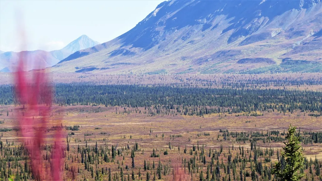
The initial section of the hike winds through subalpine forests of lodgepole pine and fir, gradually opening up to expansive meadows. During the peak summer months, these meadows are a riot of colour, adorned with a vibrant display of wildflowers. As the elevation increases, the vegetation thins, and the trail transitions to a more rugged, rocky terrain. The path becomes increasingly steep and exposed, with sections of loose scree and talus requiring careful foot placement and concentration. The final push to the summit involves navigating a steep, boulder-strewn slope, often referred to as the "scree field," which can be particularly challenging due to its unstable nature.
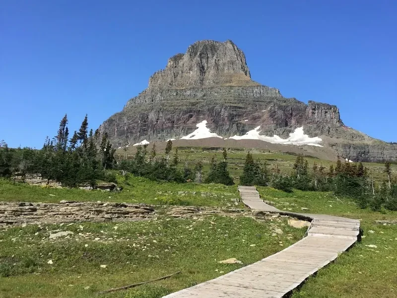
Reaching the summit of South Sister is a monumental achievement. The reward is an awe-inspiring 360-degree panorama that stretches across the vast volcanic plateau of Central Oregon. On a clear day, the views encompass the entire Cascade Range, including the prominent peaks of Mount Bachelor, Broken Top, Mount Jefferson, Mount Hood, and the Three Sisters themselves. The summit crater, a stark and beautiful testament to the volcano's geological past, offers a unique perspective on the forces that shaped this dramatic landscape. The descent, while often faster, is equally demanding on the body, particularly the knees, due to the steep, loose terrain.
Due to its challenging nature and the potential for rapidly changing weather conditions, the South Sister Summit trail is best attempted by experienced hikers who are well-prepared for an all-day alpine expedition. The window for safe passage is typically limited to the summer months when snow has receded from the higher elevations.
History and Geological Context
South Sister, also known by its Sahaptin name "K'i K'i" or "K'i K'i'i," is the youngest and most volcanically active of the Three Sisters volcanic complex. Its geological history is a fascinating narrative of explosive eruptions and effusive lava flows that have shaped the Central Oregon landscape over millennia. The volcano last erupted approximately 2,000 years ago, a relatively recent event in geological terms, and is considered dormant rather than extinct.
The area surrounding South Sister has a rich human history, with indigenous peoples, including the Warm Springs, Wasco, and Paiute tribes, utilising the land for hunting, gathering, and spiritual purposes for thousands of years. The mountains and surrounding forests provided vital resources, and the peaks themselves held cultural significance. The name "South Sister" reflects its position relative to the other two prominent peaks in the range, North Sister and Middle Sister.
The modern era of exploration and recreation in the region began with the arrival of European-American settlers and explorers in the 19th century. The development of roads and trails in the early 20th century, particularly the Cascade Lakes Scenic Highway, opened up the area to a wider range of visitors. The South Sister Summit trail, while not a formally designated "Great Walk" like some of New Zealand's iconic tracks, has long been a popular objective for serious hikers and climbers drawn to its challenging ascent and spectacular summit views. The establishment of the Three Sisters Wilderness in 1964 further protected the pristine alpine environment, ensuring its preservation for future generations.
The trail itself has evolved over time, with sections being maintained and improved by the U.S. Forest Service and volunteer groups. However, it remains a wild and rugged path, reflecting the natural character of the volcanic terrain. Understanding the geological forces that created South Sister and the human history of the region adds a deeper dimension to the experience of climbing this magnificent peak.
Seasonal Highlights and Weather Reality
The South Sister Summit trail is a strictly seasonal hike, primarily accessible during the summer months when snow and ice have melted from the higher elevations. Attempting the climb outside this window requires advanced mountaineering skills, specialised equipment, and a thorough understanding of winter alpine conditions.
Summer (July to September): This is the prime season for summiting South Sister. The snow typically recedes from the upper reaches of the trail by mid-July, making the path navigable. The alpine meadows are at their most vibrant, showcasing a spectacular display of wildflowers in July and August. Days are generally longer, offering more daylight hours for the strenuous climb. However, summer weather in the Cascades can be unpredictable. Afternoon thunderstorms are common and can develop rapidly, bringing lightning, heavy rain, and a significant drop in temperature. Hikers must be prepared for all conditions, including sun, wind, rain, and even occasional snow flurries at higher elevations.
Late Spring (June): Snowpack can linger well into June, especially on north-facing slopes and at higher elevations. While some ambitious hikers may attempt the summit in late June, it is often still too early for safe passage without snow gear and navigation skills. Conditions can be highly variable, with deep snowdrifts and icy patches posing significant hazards.
Autumn (October): As autumn approaches, snow begins to fall again on the upper slopes. By October, the trail is often impassable without winter gear. The vibrant colours of autumn foliage in the lower elevations can be beautiful, but the summit becomes increasingly inaccessible and dangerous. Early season snowstorms can occur without warning.
Winter and Early Spring (November to May): The South Sister Summit is a serious winter mountaineering objective during these months. The trail is completely covered in snow and ice, and avalanche danger is a significant concern. Ascending South Sister in winter requires expertise in ice climbing, crampon and ice axe use, avalanche assessment, and winter navigation. It is not a route for recreational hikers.
Weather Considerations: Regardless of the season, always check the mountain forecast before heading out. Conditions at the summit can be drastically different from those at the trailhead. Expect strong winds, significant temperature drops with altitude, and the potential for rapid weather deterioration. Hypothermia is a real risk, even on a sunny summer day.
Recommended Itinerary
South Sister Summit - Day Hike Itinerary
Early Morning (Approx. 5:00 AM - 6:00 AM): Trailhead Arrival and Preparation
- Arrive at the Devil's Lake Trailhead (44.1021, -121.7697).
- Ensure you have a valid Northwest Forest Pass or America the Beautiful Pass displayed.
- Final gear check: confirm all essential items are packed and accessible.
- Hydrate and have a light, energy-rich breakfast.
- Apply sunscreen and insect repellent.
- Begin the hike as early as possible to maximise daylight and avoid afternoon thunderstorms.
Morning (Approx. 6:00 AM - 11:00 AM): Ascent Through Forests and Meadows
- Distance: ~6.5 km
- Elevation Gain: ~700 m
- Follow the well-marked trail from Devil's Lake.
- The initial 3-4 km pass through lodgepole pine and fir forests.
- The trail begins to ascend more steeply, opening into subalpine meadows.
- Enjoy the vibrant wildflowers if hiking in July or August.
- Keep an eye out for the junction that leads towards the South Sister.
- The terrain becomes more exposed as you gain elevation.
Midday (Approx. 11:00 AM - 2:00 PM): The Scree Field and Summit Push
- Distance: ~3.5 km
- Elevation Gain: ~1100 m
- The trail transitions to a steep, rocky, and often loose scree field.
- This section is the most physically demanding part of the climb.
- Pace yourself, take frequent short breaks, and focus on your footing.
- The summit is now visible, providing motivation for the final push.
- Navigate carefully through the boulder-strewn terrain.
- Reach the summit crater rim and then the true summit marker.
Afternoon (Approx. 2:00 PM - 4:00 PM): Summit Experience and Descent Commencement
- Spend time at the summit (3,157 m) enjoying the panoramic views.
- Take photos and appreciate the vastness of the Cascade Range.
- Be mindful of the rapidly changing weather and the need to descend.
- Begin the descent, which is often as challenging as the ascent due to loose scree.
- Use trekking poles to aid stability and reduce impact on knees.
Late Afternoon/Early Evening (Approx. 4:00 PM - 7:00 PM): Descent to Trailhead
- Continue the descent through the scree field and meadows.
- Maintain focus on footing, especially on the steeper sections.
- The descent can be faster but is hard on the joints.
- Re-enter the forest as you approach the trailhead.
- Arrive back at Devil's Lake Trailhead.
- Ensure you have adequate water and snacks for the entire duration.
Important Notes:
- This is a strenuous day hike; start very early.
- Carry at least 3-4 litres of water per person, or a reliable water filter/purifier.
- Be prepared for rapidly changing weather conditions.
- Trekking poles are highly recommended for both ascent and descent.
- Inform someone of your hiking plans and expected return time.
- Cell service is unreliable; consider a personal locator beacon (PLB) for emergencies.
Planning and Bookings
Book Your Trip
Everything you need to plan your journey
Accommodation
Find places to stay near Bend, Oregon
Flights
Search flights to Bend, Oregon
Essential Preparation
The South Sister Summit is a significant undertaking that requires meticulous planning. Given its challenging nature and remote alpine location, thorough preparation is paramount for a safe and enjoyable experience. The closest major city is Bend, Oregon, which serves as the primary gateway for accessing the trailhead. Bend offers a full range of services, including accommodation, gear shops, grocery stores, and outdoor recreation outfitters.
Fitness: This hike demands exceptional cardiovascular fitness and leg strength. Regular training that includes hiking with a weighted pack, stair climbing, and long-distance walking is essential. Aim to be able to comfortably hike for 8-12 hours with significant elevation gain. Practice hiking on steep, uneven terrain to prepare your body for the scree and boulder fields.
Logistics: The trailhead is accessible via the Cascade Lakes Scenic Highway (Forest Road 46). This road is typically open from late May or June through October, depending on snow conditions. It can become very busy during peak summer weekends, so an early start is highly recommended to secure parking. Ensure your vehicle is in good condition, as the road can be rough in places.
Base Town: Bend, Oregon, is the ideal base for this hike. It offers a wide array of accommodation options, from budget-friendly hostels and motels to upscale hotels and vacation rentals. Bend also boasts numerous restaurants, breweries, and outdoor gear shops, making it a convenient and enjoyable place to prepare for and recover from your climb.
Trail Accommodation
This is a day hike requiring no overnight accommodation on the trail itself. Hikers typically base themselves in the nearby city of Bend, Oregon, or in smaller surrounding communities. Bend offers a comprehensive range of lodging options to suit all budgets and preferences.
Accommodation in Bend:
- Hotels and Motels: A wide selection of chain hotels and independent motels are available.
- Vacation Rentals: Numerous houses and apartments can be rented through platforms like Airbnb and VRBO.
- Campgrounds: Several campgrounds are located in and around Bend, offering tent and RV sites.
- Hostels: Budget-friendly hostel accommodations are also available.
Trailhead Facilities: The Devil's Lake Trailhead has a large parking area, but no camping facilities or overnight accommodation. It is a staging area for day hikes and overnight backpacking trips into the Three Sisters Wilderness.
Required Gear
- Sturdy Hiking Boots: Waterproof, broken-in hiking boots with good ankle support are essential for navigating the varied and challenging terrain.
- Trekking Poles: Highly recommended for stability on scree and to reduce impact on knees during the descent.
- Waterproof and Windproof Jacket: A high-quality, breathable rain jacket is crucial for protection against sudden weather changes, including rain, wind, and hail.
- Waterproof Overtrousers: Essential for staying dry and comfortable in wet conditions.
- Layered Clothing: Multiple synthetic or wool layers (base layer, mid-layer fleece or insulated jacket) are necessary to adapt to changing temperatures. Avoid cotton.
- Warm Hat and Gloves: Even in summer, temperatures at the summit can be near freezing.
- Sun Protection: High SPF sunscreen, sunglasses, and a wide-brimmed hat are vital due to the intense sun at high altitudes and reflective surfaces.
- Navigation Tools: A detailed map of the area, a compass, and a GPS device or reliable navigation app on your phone (with downloaded offline maps) are essential. Cell service is unreliable.
- Head Torch: With fresh batteries, for early starts or unexpected delays.
- First-Aid Kit: Comprehensive kit including blister treatment, pain relievers, bandages, antiseptic wipes, and any personal medications.
- Emergency Shelter: A lightweight emergency bivy sack or space blanket.
- Backpack: A comfortable daypack (30-40 litre capacity) with a rain cover.
What to Bring
- Water: Carry at least 3-4 litres of water per person. A water filter or purification tablets are highly recommended as a backup or primary source from streams.
- Food: High-energy, non-perishable food for the entire day. This includes breakfast, lunch, and plenty of snacks (energy bars, nuts, dried fruit, jerky). Pack more than you think you'll need.
- Toiletries: Biodegradable toilet paper, hand sanitiser, and a small trowel for burying human waste if away from designated areas (though packing out is preferred).
- Insect Repellent: Especially important during summer months to ward off mosquitoes and biting flies.
- Camera: To capture the stunning scenery.
- Personal Locator Beacon (PLB) or Satellite Messenger: Highly recommended for emergency communication in areas without cell service.
- Identification and Emergency Contact Information.
- Cash: For any unexpected needs or purchases in Bend.
Permits
For day hikes into the Three Sisters Wilderness, including the South Sister Summit trail, a wilderness permit is required. These permits are free and can be obtained in a couple of ways:
Self-Issue Permits at Trailhead:
- The most common method for day hikers is to self-issue a permit at the trailhead. There are usually permit stations located at popular trailheads, including Devil's Lake.
- You will need to fill out a permit card with your group's information, intended route, and dates of travel.
- Keep a copy of the permit with you at all times during your hike.
Online Reservations (Recommended for Overnight Trips):
- While not strictly mandatory for day hikes, overnight trips into the Three Sisters Wilderness require advance reservations. These can be made through the Recreation.gov website.
- It is advisable to check the Recreation.gov website for the most up-to-date information on permit requirements and availability, especially if you plan to hike during peak season or on a weekend.
Northwest Forest Pass / America the Beautiful Pass:
- A Northwest Forest Pass or an America the Beautiful Pass is required for parking at the Devil's Lake Trailhead. These passes can be purchased at ranger stations, some outdoor retailers, or online.
- If you do not have a pass, you may be able to purchase one at a self-service kiosk at the trailhead, though availability can vary.
Important Considerations:
- Always carry your permit with you. Rangers may check for compliance.
- Understand the regulations for the Three Sisters Wilderness, which include rules about campfires, group size, and waste disposal.
- For the most current information, it is always best to consult the official U.S. Forest Service website for the Deschutes National Forest or the Three Sisters Wilderness.
Other Activities in the Area
The region around South Sister and Bend, Oregon, offers a wealth of outdoor recreational opportunities beyond the summit climb:
- Hiking in the Three Sisters Wilderness: Explore numerous other trails, including the easier hikes around Devil's Lake, the Soda Creek Trail, or longer treks to Collier Memorial State Park.
- Climbing the other Sisters: For experienced mountaineers, North Sister and Middle Sister offer even more technical climbing challenges.
- Mount Bachelor Ski Resort: In winter, Mount Bachelor is a premier destination for skiing and snowboarding. In summer, it offers scenic chairlift rides and hiking opportunities.
- Cascade Lakes Scenic Highway: Drive this picturesque route, stopping at various lakes for fishing, kayaking, paddleboarding, or simply enjoying the views. Popular lakes include Sparks Lake, Elk Lake, and Hosmer Lake.
- Smith Rock State Park: Located about an hour north of Bend, Smith Rock is world-renowned for its rock climbing and offers stunning desert scenery and hiking trails.
- Lava River Cave: Explore a mile-long lava tube, one of the longest in Oregon, and experience the unique geology of the area.
- High Desert Museum: Learn about the natural and cultural history of the high desert region, with live animal exhibits and historical displays.
- Bend's Craft Beer Scene: Bend is a craft beer mecca, with numerous breweries offering a wide variety of local brews.
- Whitewater Rafting: The nearby rivers, such as the Deschutes River, offer opportunities for thrilling whitewater rafting adventures.
Safety and Conditions
Weather: The most significant safety concern on South Sister is the unpredictable mountain weather. Afternoon thunderstorms are common during summer and can bring lightning, heavy rain, hail, and rapid temperature drops. Always check the mountain forecast before you go and be prepared to turn back if conditions deteriorate. Hypothermia is a risk even in summer.
Altitude Sickness: South Sister's summit is over 3,100 metres. Some individuals may experience symptoms of altitude sickness, such as headache, nausea, and dizziness. Acclimatise by spending time at higher elevations in Bend or on shorter hikes before attempting the summit. Descend if symptoms worsen.
Trail Conditions: The trail is steep, rocky, and often covered in loose scree, especially in the upper sections. Proper footwear and trekking poles are essential for stability and to prevent injuries. Be aware of loose rocks and potential for falls.
Water Availability: While there are streams and snowmelt sources at lower elevations, water can be scarce higher up. Carry sufficient water (3-4 litres per person) and a reliable water filter or purification method.
Navigation: The trail is generally well-marked, but visibility can be severely reduced in fog or storms. Carry a map, compass, and GPS device, and know how to use them. Inform someone of your hiking plans, including your expected return time.
Wildlife: While large predators are rare, be aware of your surroundings. Black bears are present in the area, though encounters are uncommon. Store food properly if camping overnight.
Emergency Preparedness: Consider carrying a Personal Locator Beacon (PLB) or satellite messenger for emergency communication, as cell service is unreliable. Know basic first-aid and be prepared to handle minor injuries.
Leave No Trace: Adhere to Leave No Trace principles to minimise your impact on the fragile alpine environment.
Side Trips and Points of Interest
Devil's Lake: Located near the trailhead, Devil's Lake is a beautiful alpine lake offering a pleasant short hike or a place to relax before or after your summit attempt. The views of South Sister from the lake are impressive.
Moraine Lake: A smaller, often overlooked lake situated on the ascent route. It provides a tranquil spot for a break and offers lovely reflections of the surrounding peaks.
Summit Crater: Upon reaching the summit ridge, you will find yourself on the rim of the volcano's crater. While the true summit is a small rocky outcrop slightly higher, exploring the edge of the crater offers a unique geological perspective and a sense of the volcano's power.
Panoramic Views: The primary "point of interest" is the breathtaking 360-degree vista from the summit. On a clear day, you can identify numerous prominent peaks of the Cascade Range, including Mount Bachelor, Broken Top, the Middle and North Sisters, Mount Jefferson, and on exceptionally clear days, Mount Hood far to the north. The vastness of the volcanic landscape and the Deschutes National Forest stretching out below is truly awe-inspiring.
Wildflower Meadows: During the summer months (typically July and August), the meadows along the lower and middle sections of the trail burst into a spectacular display of alpine wildflowers. This offers a beautiful and colourful contrast to the starker, rocky terrain higher up.
Leave No Trace
The South Sister Summit trail traverses a sensitive alpine environment within the Three Sisters Wilderness. Practicing Leave No Trace (LNT) principles is crucial to preserving this beautiful landscape for future generations. As a visitor, you play a vital role in minimising your impact.
Plan Ahead and Prepare:
- Know the regulations for the Three Sisters Wilderness, including campfire restrictions and permit requirements.
- Pack appropriate gear for all weather conditions.
- Be prepared for self-sufficiency, as services are limited.
Travel and Camp on Durable Surfaces:
- Stay on the marked trail at all times. The alpine vegetation is fragile and slow to recover from damage.
- Avoid cutting switchbacks, especially on the steep scree sections.
- If camping overnight (which is not recommended for this hike but is permitted in designated areas), camp at least 30 m from water sources and on established campsites or durable surfaces.
Dispose of Waste Properly:
- Pack it in, pack it out. This includes all food scraps, wrappers, and any other trash.
- Use designated toilets where available. If not, dig a cathole 6-8 inches deep at least 60 m from water, trails, and campsites. Pack out all toilet paper.
Leave What You Find:
- Do not pick wildflowers or remove natural objects.
- Avoid carving or marking rocks or trees.
Minimise Campfire Impacts:
- Campfires are often prohibited in the Three Sisters Wilderness, especially during dry periods. Check current restrictions.
- If fires are permitted and you choose to have one, use an established fire ring and keep it small. Ensure the fire is completely out and cold before leaving.
Respect Wildlife:
- Observe wildlife from a distance. Never feed animals, as it can harm their health and alter their natural behaviours.
- Store food securely to prevent attracting animals.
Be Considerate of Other Visitors:
- Yield to uphill hikers.
- Keep noise levels down to preserve the wilderness experience for others.
- Allow others to enjoy the solitude and natural beauty of the area.