Snowdon Llanberis Path - The Classic Ascent of Yr Wyddfa
The Llanberis Path is the most popular and accessible route to the summit of Yr Wyddfa (Snowdon), the highest mountain in Wales and England. Standing at 1,085 metres above sea level, the peak is the crown jewel of Eryri (Snowdonia) National Park. The Llanberis Path, often referred to as the "Tourist Path," follows the line of the famous Snowdon Mountain Railway for much of its length, offering a steady, manageable gradient that makes it the preferred choice for first-time climbers, families, and those looking for a less technical but equally rewarding mountain experience. Spanning 14.5 kilometres return, the trail provides a grand introduction to the scale of the Welsh highlands, weaving through ancient landscapes shaped by volcanic activity and glacial erosion.
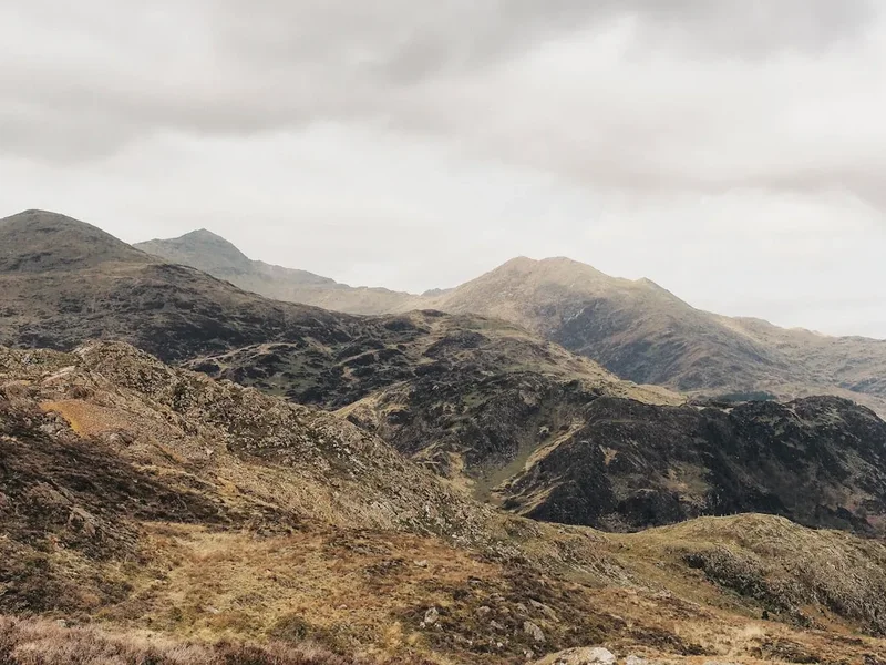
Starting from the vibrant village of Llanberis, the path ascends through a mix of paved tracks, gravel paths, and rocky steps. While it is considered the "easiest" route up the mountain, this description is relative; it remains a significant physical undertaking requiring nearly 1,000 metres of vertical gain. The journey offers breathtaking views of the Glyderau range to the north, the deep emerald waters of Llyn Du'r Arddu, and the dramatic cliffs of Clogwyn Du'r Arddu—one of the most famous rock-climbing crags in Britain. On a clear day, the summit panorama extends across the Irish Sea to the Wicklow Mountains in Ireland and south towards the peaks of Cadair Idris. This is a walk of endurance and spectacular vistas, steeped in the mountaineering heritage of North Wales.
- Distance: 14.5 km return
- Duration: 5–7 hours
- Elevation Gain: 975 m
- Difficulty: Moderate (Mountain walking experience recommended)
- Highest Point: 1,085 m (Summit of Yr Wyddfa)
- Trailhead: Victoria Terrace, Llanberis
- Terrain: Tarmac, gravel, and loose rock/scree
Overview
The Llanberis Path is a masterclass in mountain accessibility. Originally used as a pony track to carry Victorian tourists to the summit, the path today serves as the primary artery for the hundreds of thousands of visitors who flock to Yr Wyddfa each year. Its design is intentional: a wide, well-defined track that avoids the sharp ridges and scrambling sections found on the more technical routes like Crib Goch or the Watkin Path. However, its length—the longest of the six main paths—demands a steady pace and respect for the changing mountain environment. The route is characterised by its proximity to the Snowdon Mountain Railway, providing the unique experience of watching the rack-and-pinion steam engines chug their way up the steep inclines as you ascend on foot.
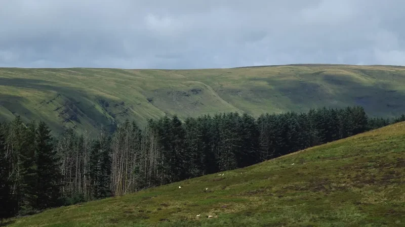
The landscape of the Llanberis Path is one of dramatic contrasts. The lower sections are dominated by the lush greenery of the Llanberis valley and the remnants of the area's industrial past, including the massive slate quarries that once defined the local economy. As you gain elevation, the vegetation thins, replaced by hardy alpine grasses and the rugged, grey rhyolite rock that forms the mountain's core. The path passes several key landmarks, including the "Halfway House" (a seasonal café) and the dramatic Clogwyn station, where the views open up to reveal the sheer scale of the Snowdon Horseshoe. The final push to the summit involves a steeper section known as Allt Moses, followed by a traverse along the ridge where the Llanberis Path joins the PyG and Miners' tracks at Bwlch Glas.
Despite its popularity, the Llanberis Path offers moments of profound mountain solitude, especially during the early morning or late afternoon. The weather on Yr Wyddfa is notoriously fickle; the mountain acts as a barrier to Atlantic weather systems, meaning the summit is often shrouded in cloud even when Llanberis is bathed in sunshine. This atmospheric variability is part of the mountain's charm, transforming the landscape from a sun-drenched playground into a moody, ethereal wilderness within minutes. Whether you are seeking a personal challenge, a family adventure, or a photographic journey, the Llanberis Path provides a safe yet exhilarating passage to the roof of Wales.
History and Cultural Context
The history of the Llanberis Path is inextricably linked to the birth of British mountaineering and the Victorian obsession with the "sublime" landscape. Before the 19th century, Yr Wyddfa was largely the domain of local shepherds and early botanists. However, the arrival of the railway in Llanberis and the subsequent construction of the Snowdon Mountain Railway in 1896 transformed the mountain into a major tourist destination. The Llanberis Path was developed from an existing bridleway used by ponies to transport wealthy visitors to the summit, where a series of rudimentary wooden huts provided basic refreshments and shelter. These early structures eventually evolved into the modern Hafod Eryri visitor centre that stands today.
Culturally, the mountain holds a sacred place in Welsh identity. In Welsh mythology, Yr Wyddfa is said to be the tomb of Rhitta Gawr, a giant defeated by King Arthur. The name "Yr Wyddfa" itself translates to "The Tumulus" or "The Burial Mound." For centuries, the mountain has inspired poets, artists, and climbers. It was here that members of the 1953 British Mount Everest expedition, including Sir Edmund Hillary and Tenzing Norgay, trained for their historic ascent, using the rugged terrain of Eryri to test their equipment and endurance. The local community in Llanberis remains deeply connected to the mountain, with many families having worked in the nearby Dinorwig slate quarry, which was once the second-largest slate mine in the world.
In recent years, there has been a significant movement to reclaim the mountain's Welsh heritage. In 2022, the Snowdonia National Park Authority voted to officially use the Welsh names Yr Wyddfa (for Snowdon) and Eryri (for Snowdonia) in all its communications. This shift reflects a broader commitment to preserving the linguistic and cultural landscape of the region. Walking the Llanberis Path is not just a physical journey; it is an immersion into a landscape where every peak, lake, and valley carries a name rooted in Welsh history and folklore.
Want more background? Read extended notes on history and cultural context → Learn more
Seasonal Highlights and Weather Reality
The experience of climbing the Llanberis Path varies dramatically with the seasons. During the peak summer months (June to August), the path is a bustling social hub. The long daylight hours and generally milder temperatures make it the safest time for less experienced walkers. However, summer also brings the largest crowds and the highest demand for parking in Llanberis. The summit visitor centre, Hafod Eryri, is typically open from late spring to autumn, providing a welcome refuge and a place to buy a famous Snowdon summit oggie (pasty).
Autumn (September to October) is many locals' favourite time to walk. The bracken on the lower slopes turns a deep russet gold, and the air is often crisper and clearer, offering the best visibility for long-distance views. The crowds begin to thin, though the weather becomes more unpredictable, with a higher frequency of Atlantic gales. Spring (April to May) brings the mountain back to life, with wildflowers appearing in the lower valleys and the last remnants of winter snow clinging to the north-facing gullies. Walkers should be aware that even in May, the summit can experience sub-zero temperatures and sudden snow showers.
Winter (November to March) transforms the Llanberis Path into a serious mountaineering undertaking. While the path is technically the "easiest," it becomes extremely hazardous when covered in snow and ice. The section known as the "Killer Convex" above Clogwyn station is particularly notorious; snow accumulates here, creating a steep, slippery slope that has led to numerous fatalities when walkers without proper equipment (ice axes and crampons) have slipped and fallen into the cliffs below. In winter, the summit visitor centre is closed, the railway does not run, and the mountain should only be attempted by those with winter mountain skills and appropriate gear. The weather can be brutal, with whiteout conditions and wind speeds exceeding 100 kilometres per hour.
Recommended Itinerary

Snowdon Llanberis Path Route Progression
Early Morning: Llanberis to the Mountain Gate
- Distance: 1.5 km
- Elevation gain: 150 m
- Time: 30–45 minutes
- Start at the Victoria Terrace trailhead, just past the Royal Victoria Hotel
- The initial section is a steep tarmac road that serves as a "wake-up call" for the legs
- Pass through a cattle grid and enter the open mountainside
- Views back over Llyn Padarn and the village of Llanberis begin to open up
- The path transitions from tarmac to a well-maintained gravel track
Morning: The First Ascent to Halfway House
- Distance: 3 km
- Elevation gain: 300 m
- Time: 1–1.5 hours
- The gradient levels out slightly as you contour around the slopes of Moel Eilio
- The Snowdon Mountain Railway track becomes visible on your left
- Pass under the first railway bridge
- Arrive at the Halfway House (approx. 570 m elevation), a seasonal café serving drinks and snacks
- This is an ideal spot for a first break and to check the weather conditions higher up
Midday: Halfway House to Clogwyn Station
- Distance: 2 km
- Elevation gain: 250 m
- Time: 1 hour
- The path steepens significantly after the Halfway House in a section known as Allt Moses
- The terrain becomes rockier and more uneven
- Pass under the second railway bridge
- Reach Clogwyn Station (approx. 770 m elevation), where the views into the Cwm Brwynog valley are spectacular
- Look down at the dark waters of Llyn Du'r Arddu and the massive cliffs of Clogwyn Du'r Arddu
- Be aware of the "Killer Convex" section here if there is any snow on the ground
Early Afternoon: The Final Push to the Summit
- Distance: 1.5 km
- Elevation gain: 275 m
- Time: 45–60 minutes
- The path follows the ridge line, offering views of the Pass of Llanberis to the north
- Reach Bwlch Glas, where the Llanberis Path meets the PyG and Miners' tracks
- The final 15 minutes follow a wide, stepped path alongside the railway line to the summit
- Arrive at the summit of Yr Wyddfa (1,085 m)
- Touch the summit cairn and enjoy 360-degree views (weather permitting)
- Visit Hafod Eryri (the visitor centre) if open for a celebratory coffee
Late Afternoon: The Descent
- Distance: 7.25 km
- Elevation loss: 975 m
- Time: 2–3 hours
- Retrace your steps down the Llanberis Path
- The descent can be surprisingly taxing on the knees; take your time on the rocky sections
- Enjoy the changing light over the Glyderau mountains as you head back towards the valley
- Finish back in Llanberis for a well-earned meal in one of the local pubs
Important Notes:
- The descent usually takes about two-thirds of the time of the ascent
- Always keep an eye on the time to ensure you are off the mountain before sunset
- The path is wide, but in thick mist, it is easy to wander off-track near the summit
- The railway line is private property; do not walk on the tracks
Planning and Bookings
Book Your Trip
Everything you need to plan your journey
Accommodation
Find places to stay near Llanberis
Flights
Search flights to Llanberis
Essential Preparation
Preparation is key to a successful day on Yr Wyddfa. While the Llanberis Path is well-marked, you should never rely solely on your phone for navigation. Download offline maps (such as OS Maps) and carry a physical map and compass. Check the mountain-specific weather forecast via the Met Office or the Mountain Weather Information Service (MWIS) before you set off. If the forecast predicts winds over 60 kilometres per hour or heavy rain, consider postponing your walk.
Llanberis is the primary hub for this trail. It is a busy village with several outdoor shops where you can buy last-minute gear or seek advice. Parking is the biggest logistical challenge; the main car parks in Llanberis fill up very early (often by 8:00 AM on weekends). Consider using the "Sherpa'r Wyddfa" bus service, which connects the various trailheads and villages around the mountain, allowing for more flexible planning and reducing the pressure on local infrastructure.
Trail Accommodation
This is a day hike requiring no overnight accommodation on the mountain itself. Camping is strictly prohibited on Yr Wyddfa and within the Eryri National Park without prior permission from the landowner. However, Llanberis offers a wide range of accommodation options for before and after your hike.
Accommodation Options in Llanberis:
- Hotels: The Royal Victoria Hotel is located right at the foot of the path. Other options include the Padarn Hotel and various boutique guest houses.
- Hostels: The YHA Llanberis is a popular choice for hikers, offering both dorm beds and private rooms. There are also several independent climbers' hostels in the village.
- Campsites: There are several well-equipped campsites on the outskirts of Llanberis and in the nearby Nant Peris valley. These offer facilities for tents, campervans, and motorhomes.
- Bunkhouses: Ideal for groups, these provide basic, affordable accommodation with shared kitchen facilities.
Required Gear
- Walking Boots: Sturdy, waterproof boots with good ankle support and a "vibram" style sole for grip on wet rock. Trainers are not recommended for the upper sections.
- Waterproof Layers: A high-quality waterproof jacket and overtrousers. The weather can turn from sun to torrential rain in minutes.
- Clothing: Use a layering system. Avoid cotton (which stays cold and wet); instead, wear moisture-wicking synthetic or merino wool base layers and a warm fleece mid-layer.
- Backpack: A 20–30 litre day pack with a waterproof cover or internal dry bags.
- Navigation: OS Landranger Map 115 or Explorer OL17, and a reliable compass.
- Head Torch: Essential even if you plan to be back by daylight, in case of delays or emergencies.
- First Aid Kit: Including blister plasters, antiseptic wipes, and any personal medication.
- Whistle: For signalling in an emergency (six short blasts, one minute pause, repeat).
What to Bring
- Water: At least 2 litres per person. There are no reliable water sources on the path itself, and the water at the Halfway House is for customers.
- Food: High-energy snacks (nuts, dried fruit, chocolate) and a substantial lunch. You will burn a significant number of calories during the 975 m ascent.
- Sun Protection: Sunscreen, sunglasses, and a hat. The sun is much stronger at high altitudes, and there is very little shade on the path.
- Warm Hat and Gloves: Even in summer, the summit can be 10–15 degrees Celsius colder than the valley, with significant wind chill.
- Mobile Phone and Power Bank: For emergency calls and navigation, but remember that signal is intermittent in the valleys.
- Emergency Shelter: A lightweight foil blanket or group shelter (bothy bag) is a wise addition to any mountain pack.
Permits
There are no permits required to walk the Llanberis Path or any of the other main routes up Yr Wyddfa. Access to the mountain is free under the Countryside and Rights of Way (CROW) Act 2000. However, while the walking is free, the associated logistics often require advance booking and payment.
Parking and Transport Costs:
- Llanberis Parking: Expect to pay between £10 and £15 for a full day of parking in the main village car parks. These are "pay and display" or app-based. During peak season, it is highly recommended to arrive before 8:00 AM.
- Sherpa'r Wyddfa Bus: A day ticket for the Sherpa bus network costs approximately £5 for adults. This is a cost-effective and environmentally friendly way to reach the trailhead.
- Snowdon Mountain Railway: If you plan to take the train up or down (subject to availability), tickets must be booked well in advance, especially for the steam service. A return trip costs approximately £40–£70 depending on the service and season. Note: You cannot rely on buying a "standby" ticket at the summit to get down; these are rarely available.
Group Events: If you are organising a large charity event or a guided group of more than 10 people, you are encouraged to register your event with the Snowdonia National Park Authority. This helps the wardens manage the volume of people on the mountain and ensures your group has the latest safety information. There is no fee for this registration, but donations to the "Snowdonia Society" or "Real 3 Peaks" are encouraged to help with path maintenance.
Other Activities in the Area
Llanberis is the "outdoor capital" of North Wales, and there is plenty to do if you have extra time or if the weather is too poor for a summit attempt:
- National Slate Museum: Located in the Victorian workshops of the Dinorwig Quarry, this free museum offers a fascinating look at the industry that shaped the region. Don't miss the slate splitting demonstrations.
- Llyn Padarn: This stunning glacial lake offers opportunities for kayaking, paddleboarding, and wild swimming. The "Lonely Tree" on the northern shore is a famous spot for photographers.
- Electric Mountain: Take a tour of the Dinorwig Power Station, a massive pumped-storage hydroelectric scheme built inside the mountain (check for reopening dates as it has been undergoing refurbishment).
- Dolbadarn Castle: A 13th-century tower built by Llywelyn the Great, offering commanding views over the lakes and the mountain passes.
- The Snowdon Mountain Railway: Even if you don't take it to the summit, visiting the station and watching the trains depart is a classic Llanberis experience.
- Padarn Country Park: Offers several lower-level woodland walks and trails through the old quarry hospital and workshops.
Safety and Conditions
Pre-Departure Checks:
- Check the Met Office Mountain Forecast for Yr Wyddfa. Pay close attention to "Feels Like" temperatures and wind gust speeds.
- Ensure your phone is fully charged and you have a backup power source.
- Tell someone exactly which route you are taking and what time you expect to be back.
- Check the Snowdon Live website or social media for real-time updates on summit conditions and visitor centre opening times.
Mountain Hazards: The Llanberis Path is often underestimated because of its "tourist" reputation. The most common hazards include:
- Hypothermia: Can occur even in summer if you get wet and the wind picks up. Always carry a dry spare warm layer.
- Dehydration: The climb is long and exposed. There is no shade, and the physical exertion is high.
- The "Killer Convex": As mentioned, this section above Clogwyn station is lethal in winter conditions. If the path is covered in snow and you do not have an ice axe and crampons, turn back.
- Navigation in Mist: The summit plateau is wide and featureless. In thick cloud, it is very easy to follow the wrong path down (e.g., accidentally taking the Watkin Path instead of the Llanberis Path). Use a compass to verify your direction of travel.
Emergency Procedures: If you get into serious difficulty and cannot continue, dial 999 and ask for Police and then Mountain Rescue. Be prepared to give your location (ideally using a grid reference or a "What3Words" address), the number of people in your party, and the nature of the injuries or emergency. The Llanberis Mountain Rescue Team is one of the busiest in the UK; please only call them in a genuine emergency.
Travel insurance: While mountain rescue in the UK is a free service provided by volunteers, having insurance that covers "hiking up to 1,500m" is recommended for any medical costs or trip cancellations.
Side Trips and Points of Interest
Ceunant Mawr Waterfall: Located just a short detour from the start of the path in Llanberis. This spectacular waterfall (also known as Llanberis Falls) plunges over 30 metres in two stages into a deep wooded gorge. It is particularly impressive after heavy rain and is a great spot for a quick photo before you begin the main ascent.
Clogwyn Du'r Arddu: Known to climbers as "Cloggy," this is one of the most significant cliffs in the history of British rock climbing. While the Llanberis Path stays well away from the edge, you can look down into the cwm (valley) from near Clogwyn Station to see the dark, imposing face of the cliff. It is a place of great atmosphere and geological drama.
Hafod Eryri (Summit Visitor Centre): Designed by architect Ray Hole and opened in 2009, the visitor centre is built from Welsh granite and designed to withstand the extreme summit weather. It houses a café, toilets, and a small gift shop. Even if you don't buy anything, the floor-to-ceiling windows offer a unique perspective on the surrounding peaks while you shelter from the wind.
The Summit Cairn: The very highest point is marked by a man-made stone plinth with a brass circular map (a toposcope) that identifies the distant landmarks visible on the horizon. On a clear day, you can see as far as the Isle of Man and the Lake District.
Leave No Trace
Yr Wyddfa is one of the most visited mountains in the world, and the sheer volume of people places an enormous strain on the environment. As a walker, you have a responsibility to minimise your impact and help preserve this landscape for future generations. The "Leave No Trace" principles are essential here.
Your responsibility as a walker:
- Take your litter home: This includes "organic" waste like banana skins and orange peels. In the cold mountain environment, these can take years to decompose and are unsightly and harmful to local wildlife.
- Stick to the path: The Llanberis Path is wide for a reason. Walking on the edges causes "path creep," where the vegetation is destroyed and the soil erodes, leading to ugly scars on the mountainside.
- No Wild Camping: Use the official campsites in the valley. Wild camping on the mountain leads to soil compaction, litter, and human waste issues.
- Respect the Wildlife: You may see feral goats, ravens, or even the rare Snowdon Lily (Lloydia serotina) in the higher gullies. Observe from a distance and never pick flowers.
- Human Waste: Use the toilets in Llanberis or at the summit visitor centre (when open). If you are caught short, ensure you are at least 50 metres from any water source and bury waste deeply. Carry out all toilet paper and sanitary products.
- Keep Dogs on Leads: There are often sheep grazing on the lower and middle slopes. Even the most well-behaved dog can spook livestock, leading to injury or death.
The "Real 3 Peaks" challenge and local volunteer groups spend hundreds of hours every year picking up tonnes of rubbish from the mountain. Please don't add to their workload. Leave the mountain cleaner than you found it.