Slieve Donard Ascent
The Slieve Donard Ascent is a classic mountain walk in the heart of the Mourne Mountains, County Down, Northern Ireland. This challenging route takes you to the highest peak in the range, offering breathtaking panoramic views across the Irish Sea, the surrounding mountains, and on a clear day, even to the Isle of Man and the Scottish coast. The ascent is steep and can be demanding, particularly the final push to the summit, but the rewards are immense. The trail winds through varied terrain, from open moorland and rocky paths to the iconic Mourne Wall, a testament to the region's agricultural history.
- Distance: 9.0 km one-way
- Elevation gain: 850 m
- Duration: 3-4 hours (one-way)
- Difficulty: Challenging
- Best Time: April to October
- Closest City: Newcastle
- Trailhead Access: Nearest airport: Belfast International (BFS). From Belfast, take bus/train to Newcastle. By car: A2 to Newcastle, follow signs to Donard Car Park. Parking available (fee may apply). No permits needed. GPS: 54.2053, -5.8854.
- Coordinates: 54.2053, -5.8854
Overview
The Slieve Donard Ascent is a quintessential Mourne Mountains experience, a journey to the summit of Northern Ireland's highest peak. This route is not for the faint-hearted; it demands a good level of fitness and preparation due to its significant elevation gain and often rugged terrain. The walk typically begins from the Donard Car Park in Newcastle, a popular seaside town that serves as the gateway to the Mournes.
The initial stages of the ascent are often on well-trodden paths, gradually leading you away from the coastal plains and into the embrace of the mountains. As you climb, the landscape transforms. You'll traverse open moorland, dotted with heather and gorse, with the distinctive granite formations of the Mournes becoming increasingly prominent. The air grows cooler, and the sounds of the town fade, replaced by the whisper of the wind and the calls of mountain birds.
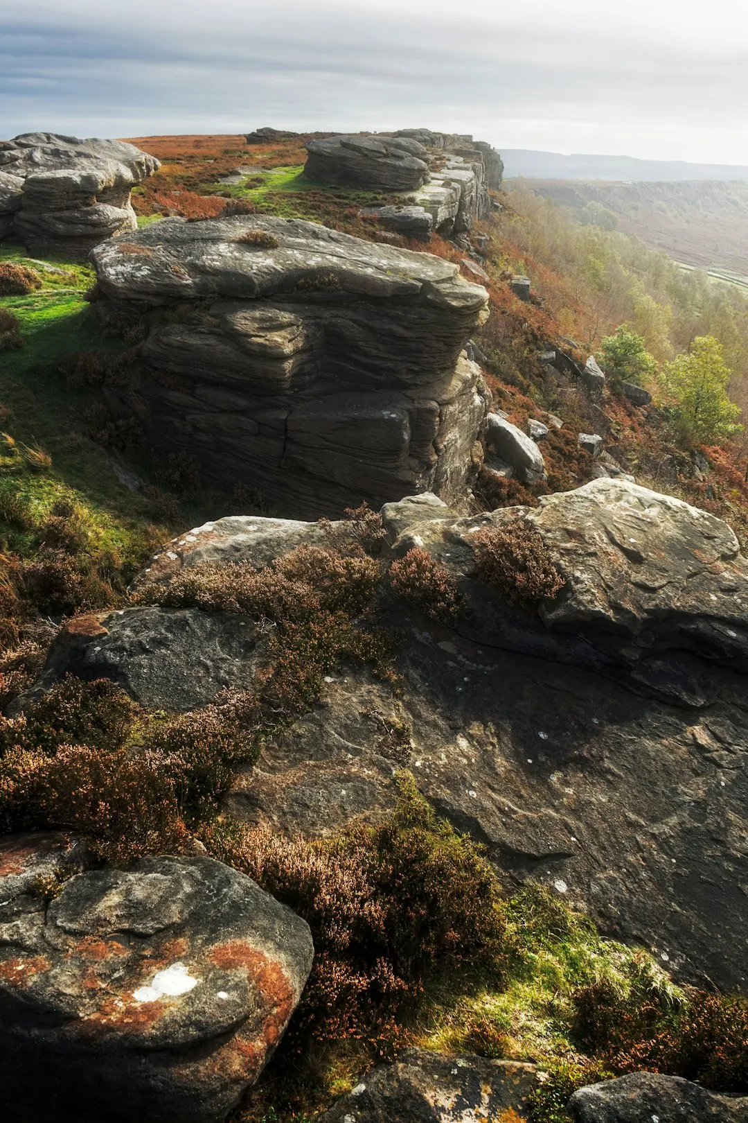
A significant feature of the route is the Mourne Wall. This dry-stone wall, stretching for over 35 kilometres and built between 1904 and 1922 by the Belfast Water Commissioners, encloses the catchment area for the Silent Valley Reservoir. Following sections of this wall provides a sense of historical context and a clear navigational aid for much of the climb. The wall itself is a remarkable feat of engineering, constructed without mortar and using local granite.
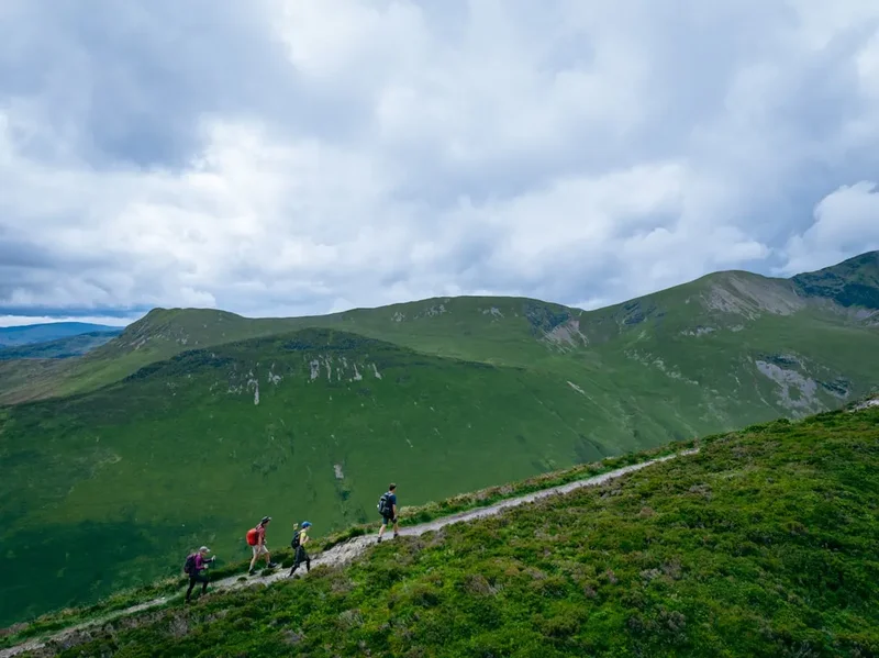
The final push to the summit of Slieve Donard (850 metres) is the most demanding part of the hike. The path becomes steeper and rockier, requiring careful foot placement. The summit itself is marked by a large cairn and the remains of an ancient stone fort. From this vantage point, the views are truly spectacular. On a clear day, you can see the entire sweep of Dundrum Bay, the coast stretching north and south, the rugged peaks of the Mournes spreading out below, and across the Irish Sea to the Mull of Galloway in Scotland and the Isle of Man. The sense of accomplishment upon reaching the summit is profound.
The descent offers a different perspective, allowing you to appreciate the scale and beauty of the landscape you've just conquered. It's crucial to be mindful of your footing on the way down, as tired legs can lead to missteps. The Slieve Donard Ascent is a rewarding challenge that offers a deep connection with the wild beauty of the Mourne Mountains.
History and Cultural Context
The Mourne Mountains have a rich history, shaped by both natural forces and human endeavour. For centuries, these mountains have been a source of granite, a vital resource for building and industry. The dry-stone walls that crisscross the landscape, including the iconic Mourne Wall, are a testament to the hard work and ingenuity of generations of farmers and labourers who shaped the land for agriculture and water management.
The construction of the Mourne Wall is a particularly significant chapter in the region's history. Built between 1904 and 1922, this massive undertaking by the Belfast Water Commissioners was designed to protect the water catchment area for the Silent Valley Reservoir. The wall, stretching over 35 kilometres and using an estimated 1.5 million stones, was a monumental task, employing hundreds of local men. It stands today not only as a functional boundary but also as a symbol of human perseverance and a remarkable feat of dry-stone masonry.
Slieve Donard itself, at 850 metres, has been a focal point for human activity for millennia. Archaeological evidence suggests human presence in the Mournes dating back to the Neolithic period. The summit is crowned by the remains of a large stone fort, believed to have been constructed by Iron Age inhabitants. This suggests the mountain was considered a place of strategic importance or spiritual significance long before modern times.
In more recent history, the Mourne Mountains have become a popular destination for walkers, climbers, and artists. Their dramatic landscapes have inspired countless paintings, poems, and stories, capturing the wild beauty and rugged character of the region. The area's natural beauty and historical significance are recognised through its designation as an Area of Outstanding Natural Beauty (AONB).
Seasonal Highlights and Weather Reality
The Mourne Mountains experience distinct seasons, each offering a different character to the Slieve Donard Ascent.
Spring (April-May): This is a beautiful time to ascend Slieve Donard. The landscape begins to awaken, with wildflowers appearing on the lower slopes and the heather starting to show signs of new growth. The weather can be variable, with a mix of sunny days and occasional showers. Temperatures are generally cool, making for comfortable hiking conditions. The longer daylight hours are also a significant advantage.
Summer (June-August): Summer offers the warmest temperatures and the longest daylight hours, ideal for extended hikes. The heather is often in full bloom, creating a vibrant purple carpet across the hillsides. However, summer can also bring increased visitor numbers, and the weather can still be unpredictable. Sandflies can be present, though generally less of an issue than in some other mountainous regions. Clear summer days provide the best opportunities for far-reaching views from the summit.
Autumn (September-October): Autumn is a spectacular season in the Mournes. The heather turns to shades of russet and gold, and the bracken takes on rich autumnal colours. The air is often crisp and clear, offering excellent visibility. This is a popular time for hikers, and the cooler temperatures are very pleasant for strenuous ascents. However, days are shorter, and the possibility of early snow on the higher peaks increases as the season progresses.
Winter (November-March): Winter ascents of Slieve Donard are for experienced and well-equipped hikers only. The mountain can be covered in snow and ice, requiring the use of crampons and ice axes. Visibility can be extremely poor due to fog and low cloud. Temperatures will be significantly colder, and the wind chill can be severe. While challenging, a winter ascent can offer a unique and dramatic experience for those with the necessary skills and gear.
Weather Reality: It is crucial to understand that mountain weather is notoriously changeable. Even on a clear summer morning, conditions can deteriorate rapidly. Fog, strong winds, and heavy rain can descend without warning, significantly impacting visibility and making navigation difficult. Always check the mountain forecast before setting out and be prepared for all eventualities.
Recommended Itinerary
Slieve Donard Ascent (One-Way)
Start: Donard Car Park, Newcastle
- Early Morning (Approx. 9:00 AM): Arrive at Donard Car Park. Ensure you have checked the weather forecast and are prepared for the conditions. Familiarise yourself with the route and any potential hazards.
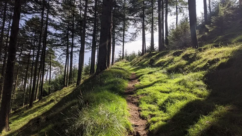
- Morning (Approx. 9:30 AM - 12:30 PM): Begin the ascent from the car park. The initial section follows a clear path, often alongside the Glen River. You will soon reach the edge of the forest and begin climbing onto the open moorland. The path can be steep and rocky in places.
- Midday (Approx. 12:30 PM - 1:30 PM): Reach the Mourne Wall. This is a good point to take a break, have some lunch, and assess your progress. The wall will guide you for a significant portion of the remaining climb. The terrain becomes more rugged as you gain altitude.
- Afternoon (Approx. 1:30 PM - 3:00 PM): Continue the ascent along or near the Mourne Wall. The final push to the summit is the most challenging, with a steep, rocky incline. Take your time, maintain a steady pace, and focus on your footing.
- Summit (Approx. 3:00 PM): Arrive at the summit of Slieve Donard (850 m). Enjoy the panoramic views, take photographs, and celebrate your achievement. Spend time appreciating the vastness of the landscape.
- Descent (Approx. 3:30 PM onwards): Begin your descent back towards Newcastle. The descent can be as challenging as the ascent, requiring careful navigation and attention to your footing, especially on loose or rocky sections.
- Late Afternoon (Approx. 5:00 PM - 6:00 PM): Arrive back at Donard Car Park.
Important Notes:
- This is a challenging hike requiring good physical fitness.
- The route is approximately 9.0 km one-way, with a significant elevation gain of 850 m.
- Allow ample time for the ascent and descent, including breaks.
- Weather can change rapidly; always check the forecast and be prepared for adverse conditions.
- Wear sturdy, broken-in hiking boots with good ankle support.
- Carry sufficient water and high-energy snacks.
- A map and compass are essential, even on well-marked routes, as visibility can be poor.
- Inform someone of your hiking plans and expected return time.
Planning and Bookings
Book Your Trip
Everything you need to plan your journey
Accommodation
Find places to stay near Newcastle
Flights
Search flights to Newcastle
Essential Preparation
Planning your Slieve Donard Ascent is crucial for a safe and enjoyable experience. The primary considerations are physical fitness, appropriate gear, and understanding the weather conditions. Given the challenging nature of the climb, a good level of cardiovascular fitness and leg strength is essential. Regular hiking or strenuous exercise in the weeks leading up to your trip will be beneficial.
The closest town to the trailhead is Newcastle, a popular seaside resort that offers a range of accommodation options, from budget guesthouses and bed and breakfasts to hotels. Newcastle also provides essential services such as supermarkets for purchasing food and supplies, outdoor gear shops for last-minute purchases, and numerous cafes and restaurants for pre- or post-hike meals. Public transport links to Newcastle are available from major cities like Belfast, making it accessible for those travelling without a car. If driving, the Donard Car Park is well-signposted from the town centre.
Trail Accommodation
This is a day hike requiring no overnight accommodation. Hikers typically start from Newcastle, complete the ascent and descent within a single day, and return to their accommodation in the town or depart from the area.
Required Gear
- Hiking Boots: Sturdy, waterproof, ankle-supporting hiking boots are essential. Ensure they are well broken-in to prevent blisters.
- Waterproof Jacket: A high-quality waterproof and windproof jacket with a hood is vital. Mountain weather can change rapidly, and you must be prepared for rain and strong winds.
- Waterproof Overtrousers: Essential for keeping your legs dry and protected from wind and rain.
- Warm Layers: Several layers of clothing are recommended, including a moisture-wicking base layer (e.g., merino wool or synthetic), an insulating mid-layer (e.g., fleece or down jacket), and a warm hat and gloves. Even in summer, the summit can be cold and windy.
- Backpack: A comfortable daypack (20-30 litres) to carry your essentials.
- Navigation: A detailed map of the Mourne Mountains and a compass are crucial. Familiarise yourself with how to use them. A GPS device or a reliable smartphone with offline maps can be a useful supplement, but should not be relied upon solely.
- Head Torch: With spare batteries, in case your hike takes longer than expected or you encounter unexpected delays.
- First Aid Kit: A comprehensive kit including blister treatment, pain relievers, antiseptic wipes, bandages, and any personal medications.
- Sun Protection: Sunscreen, sunglasses, and a sun hat, even on cloudy days, as UV radiation can be strong at higher altitudes.
What to Bring
- Food: High-energy snacks such as energy bars, nuts, dried fruit, and sandwiches. Pack more than you think you will need.
- Water: At least 2 litres of water per person. There are no reliable water sources on the upper slopes of Slieve Donard, so carry all you need.
- Water Treatment (Optional): If you plan to refill from streams lower down, a water filter or purification tablets can be considered, but carrying sufficient water is the safest approach.
- Toiletries: Hand sanitiser, toilet paper (and a bag to pack it out), and any personal hygiene items.
- Mobile Phone: Fully charged, for emergency use. Signal can be intermittent in the mountains.
- Emergency Whistle: For signalling in an emergency.
- Trekking Poles (Optional): Can help reduce strain on knees during the descent and provide stability on uneven terrain.
- Small Towel: Useful for drying off after rain or for wiping sweat.
Permits
No permits are required to hike Slieve Donard. The Mourne Mountains are largely accessible to the public, and the trails are open for recreational use. However, it is important to be aware of the regulations and guidelines set by the local authorities, such as the National Trust and the Mourne Heritage Trust, to ensure responsible access and to protect the natural environment.
While no specific permits are needed for individuals or small groups undertaking the standard ascent, larger organised groups or those planning commercial activities may need to seek permission or adhere to specific guidelines. It is always advisable to check with local information centres or relevant authorities if you are planning an expedition that deviates from a standard day hike.
The primary "requirement" for hiking Slieve Donard is preparedness. This includes having the correct gear, a good level of fitness, and a thorough understanding of the route and potential weather conditions. Respecting the environment and following Leave No Trace principles are paramount.
Other Activities in the Area
Newcastle and the surrounding Mourne Mountains offer a wealth of activities for visitors:
- Mourne Way: A long-distance walking route that traverses the entire Mourne range, offering multi-day hiking opportunities.
- Silent Valley Reservoir: Visit the impressive reservoir and its visitor centre, learning about the history of the Mourne Wall and the water supply for Belfast.
- Tollymore Forest Park: Explore the ancient woodland with its network of walking trails, natural play areas, and opportunities for cycling.
- Castlewellan Forest Park: Home to the National Arboretum, a beautiful lake for watersports, and challenging mountain bike trails.
- Coastal Walks: Enjoy the scenic coastline around Newcastle, with opportunities for bracing walks along the beach or promenade.
- Rock Climbing and Bouldering: The Mourne Mountains offer numerous opportunities for climbers, with a variety of crags and boulder problems.
- Mountain Biking: Designated trails in Castlewellan and Tollymore Forest Parks cater to various skill levels.
- Kayaking and Water Sports: Newcastle offers opportunities for sea kayaking and other water-based activities.
- Local Cuisine: Enjoy fresh seafood and traditional Irish fare in the many restaurants and pubs in Newcastle.
Safety and Conditions
Weather Preparedness: The most critical safety aspect for Slieve Donard is being prepared for the weather. Mountain weather is unpredictable and can change rapidly. Always check the Met Éireann mountain forecast for the Mourne Mountains before you set off. Be prepared for strong winds, heavy rain, fog, and significantly lower temperatures at the summit compared to Newcastle. Hypothermia is a real risk, even in summer, if you become wet and cold.
Navigation: While the main path to Slieve Donard is relatively well-trodden, visibility can drop to near zero in fog or heavy rain. Relying solely on the path can be dangerous. Carry a map and compass and know how to use them. The Mourne Wall serves as a useful navigational aid for much of the route, but it is not infallible, especially in poor visibility.
Terrain: The terrain is varied and can be challenging. The lower slopes may be boggy, while the upper sections are rocky and uneven. Loose scree can be present, especially on steeper sections. Ensure you have appropriate footwear with good grip and ankle support. Take care with your footing, particularly on the descent, as tired legs can lead to mistakes.
Physical Fitness: Slieve Donard is a strenuous hike with a significant elevation gain. Ensure you are physically fit enough for the challenge. If you are unsure, consider starting with shorter, less demanding walks in the Mournes.
Communication: Mobile phone signal can be unreliable in the mountains. Inform someone of your hiking plans, including your intended route and estimated return time. Carry a fully charged mobile phone and consider a personal locator beacon (PLB) for remote areas or if hiking alone.
Emergency Procedures: In case of an emergency, call 999 or 112 and ask for Mountain Rescue. Provide your location as accurately as possible. If you encounter someone in distress, offer assistance if it is safe to do so, but do not put yourself at risk.
Sandflies: While not as prevalent as in some other regions, sandflies can be present, particularly during warmer months. Carry insect repellent if you are concerned.
Side Trips and Points of Interest
The Mourne Wall: This iconic dry-stone wall is a significant feature of the Slieve Donard ascent. Following sections of it provides a sense of historical context and a clear navigational aid. The wall itself is a remarkable feat of engineering, built without mortar and using local granite.
Glen River Path: The initial section of the hike often follows the Glen River. This picturesque path offers lovely views of the river and the surrounding woodland before you ascend onto the open mountain.
Summit Cairn and Fort Remains: At the summit of Slieve Donard, you will find a large cairn and the remnants of an ancient stone fort. These historical features offer a glimpse into the past and the long human history of the Mourne Mountains.
Panoramic Views: The primary point of interest is the breathtaking 360-degree view from the summit. On a clear day, you can see across Dundrum Bay, the Irish Sea, the Isle of Man, Scotland, and the vast expanse of the Mourne Mountains themselves. This is the ultimate reward for your efforts.
Silent Valley Reservoir: While not directly on the ascent route, the Silent Valley Reservoir is a significant landmark in the Mourne Mountains and the reason for the construction of the Mourne Wall. It is worth visiting as part of a broader exploration of the area.
Leave No Trace
The Mourne Mountains are a precious natural environment, and it is essential that all visitors practice Leave No Trace principles to preserve their beauty and ecological integrity for future generations. As you ascend Slieve Donard, remember that you are treading on a landscape that has been shaped by nature and human history over millennia.
Plan Ahead and Prepare: Understand the route, check the weather forecast, and pack appropriate gear. This minimises the need for unexpected actions that could impact the environment.
Travel and Camp on Durable Surfaces: Stick to marked trails and paths. Avoid walking on fragile vegetation, especially mosses and heather, which can take a long time to recover. The paths on Slieve Donard are generally well-defined, but care should be taken on steeper, looser sections.
Dispose of Waste Properly: Pack out everything you pack in. This includes all food scraps, wrappers, and any other litter. Do not bury or burn waste. Use designated bins where available, but be prepared to carry all your rubbish back with you.
Leave What You Find: Do not remove rocks, plants, or any other natural or historical items from the mountains. Take photographs and memories instead.
Minimise Campfire Impacts: Campfires are generally not permitted in the Mourne Mountains, and are certainly not relevant for a day hike like the Slieve Donard Ascent. If camping overnight in designated areas (which is not typical for this hike), use a stove for cooking.
Respect Wildlife: Observe wildlife from a distance and do not feed any animals. Feeding wild animals can harm their health and alter their natural behaviours.
Be Considerate of Other Visitors: Keep noise levels down, especially on the summit. Yield to other hikers on narrow paths. Respect the peace and tranquility of the mountains.
By adhering to these principles, you help ensure that the Slieve Donard Ascent remains a wild and beautiful experience for everyone.