Skyline Trail - Jasper's High-Altitude Masterpiece
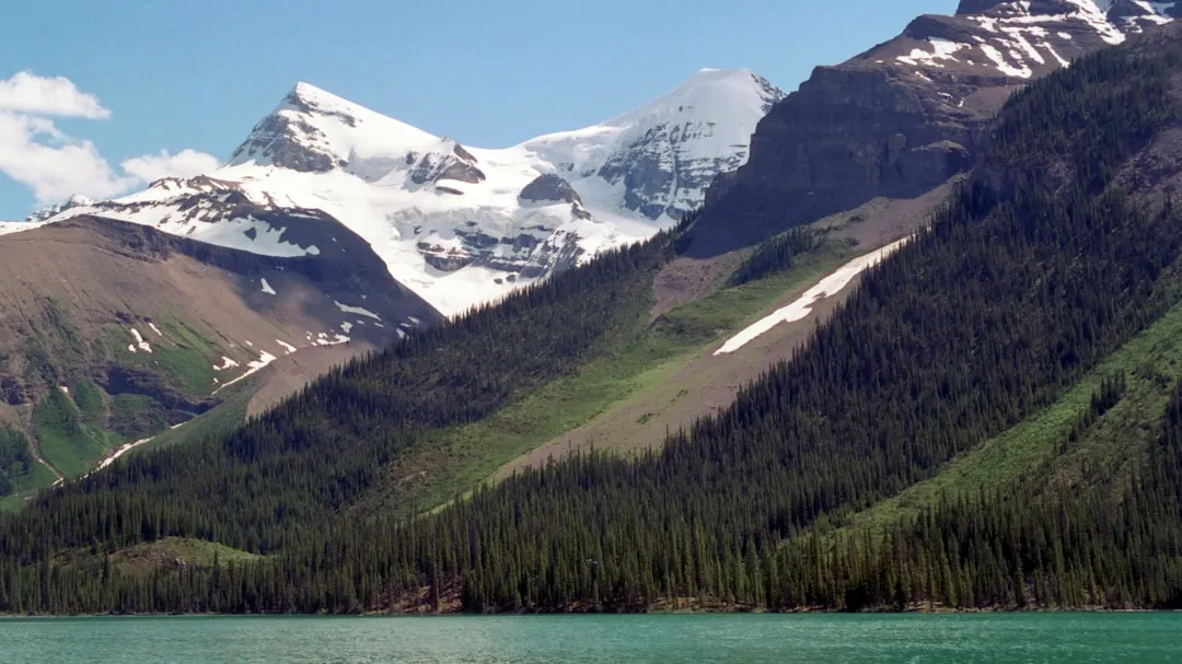
The Skyline Trail is widely considered the crown jewel of Jasper National Park and one of the most spectacular multi-day backpacking routes in the Canadian Rockies. Stretching 44.0 kilometres across the Maligne Range, this trail is defined by its extraordinary elevation profile: more than 25 kilometres of the journey takes place above the treeline, offering hikers an unparalleled experience of walking along the "spine" of the mountains. This sustained high-altitude exposure provides constant, 360-degree panoramas of jagged limestone peaks, sprawling glacial valleys, and the turquoise shimmer of Maligne Lake far below. It is a journey through a landscape of extremes, where delicate alpine wildflowers bloom in the shadow of permanent snowfields and the weather can shift from summer heat to a winter blizzard in a matter of minutes.
Unlike many mountain trails that climb to a single pass before descending back into the forest, the Skyline Trail maintains its height, traversing three major mountain passes—Little Shovel, Big Shovel, and the formidable Notch. This unique geography creates a sense of immense scale and isolation, even though the trail is located within one of Canada's most famous national parks. The route is typically completed in two to four days, allowing walkers to immerse themselves in the silence of the high alpine. From the lush subalpine meadows of Snowbowl to the stark, lunar-like terrain of the Amber Mountain ridge, the Skyline Trail is a masterclass in Rocky Mountain ecology and geology. It is a challenging, rewarding, and deeply moving trek that demands careful preparation and a deep respect for the unpredictable nature of the Canadian wilderness.
- Distance: 44.0 km one-way
- Elevation Gain: 1,450 m
- Duration: 2–4 days
- Difficulty: Challenging
- Best Time: Late July to mid-September
- Highest Point: The Notch (2,510 m)
- Trailhead: Maligne Lake (South) to Signal Mountain (North)
- Direction: Recommended South to North (Maligne Lake to Jasper)
Overview
The Skyline Trail is a high-altitude odyssey that captures the raw essence of the Canadian Rockies. While the total distance of 44 kilometres might seem manageable for experienced hikers, the challenge lies in the sustained elevation and the technical nature of the terrain. The trail begins at the world-famous Maligne Lake, at an elevation of approximately 1,690 metres, and climbs steadily into the alpine. The defining characteristic of the Skyline is its commitment to the heights; once you ascend Little Shovel Pass on the first day, you rarely drop back into the dense forest until the final descent on the last day. This makes the trail highly susceptible to weather, but also ensures that the views are constant and breathtaking.
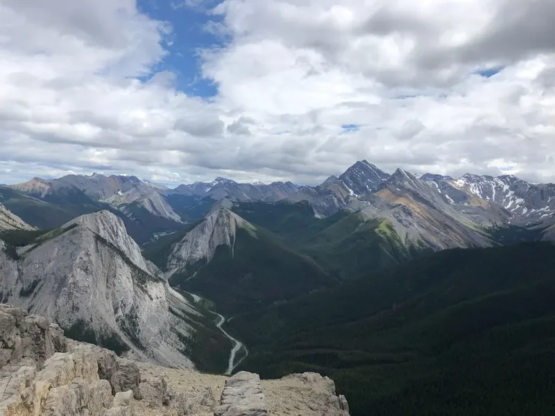
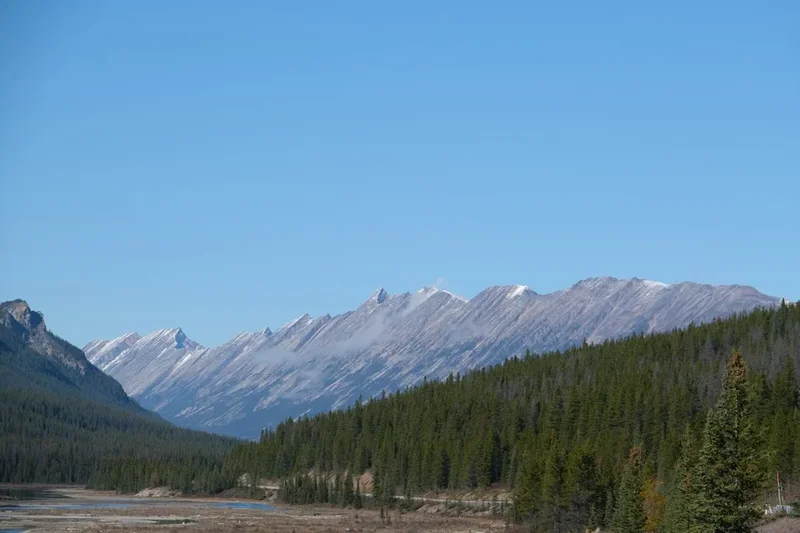
The route is traditionally hiked from South to North, starting at Maligne Lake and ending at the Signal Mountain trailhead near the Jasper townsite. This direction is favoured because it begins at a higher elevation, meaning you do less total climbing than if you started from the Jasper side. The "crux" of the trail is a section known as The Notch, a narrow gap in the mountain ridge that requires a steep, often snow-covered scramble to reach the highest point of the trek at 2,510 metres. From here, the trail follows the ridgeline for several kilometres, providing what many consider the best views in all of Jasper National Park. To the west, the peaks of the Trident Range pierce the sky, while to the east, the vast Maligne Valley stretches toward the horizon.
The landscape is a tapestry of diverse ecosystems. You will traverse "Snowbowl," a wide subalpine basin famous for its vibrant displays of Indian Paintbrush, Western Anemone, and Arnica. You will cross high-altitude plateaus where the only residents are whistling marmots and the occasional herd of woodland caribou. The final leg of the journey involves a long, knee-testing descent down an old fire road, transitioning from the stark beauty of the alpine back into the thick Douglas fir and lodgepole pine forests of the Athabasca Valley. Because of its popularity and the fragility of the alpine environment, the trail is strictly managed by Parks Canada, with designated campsites that must be booked months in advance. This regulation preserves the sense of solitude that makes the Skyline Trail so special, ensuring that every hiker can experience the mountains in their purest form.
History and Cultural Context
The history of the Skyline Trail is inextricably linked to the broader story of Jasper National Park and the exploration of the Canadian Rockies. Long before European surveyors arrived, the Maligne Range was part of the traditional territories of the Stoney Nakoda, Cree, and Métis peoples. These Indigenous groups used the valleys and passes for hunting, gathering, and travelling between the Athabasca and Saskatchewan River systems. The mountains were not merely physical barriers but spiritual landscapes, rich with oral histories and traditional knowledge. While the high ridges of the Skyline were not permanent settlement sites, the passes were vital corridors for seasonal movement.
The "modern" discovery of the route is often attributed to Mary Schäffer Warren, a Quaker explorer, artist, and photographer from Philadelphia. In 1911, Schäffer was commissioned by the Geological Survey of Canada to survey Maligne Lake, which she had "rediscovered" based on maps provided by Stoney guide Samson Beaver. During her explorations of the region, her party traversed sections of what would become the Skyline Trail. Schäffer’s writings and stunning photographs of the Maligne Range helped popularise the area, leading to the eventual establishment of Jasper National Park as a premier destination for mountain tourism. Her legacy is still felt today, with many landmarks in the area bearing names she bestowed upon them.
In the early 20th century, the trail was further developed by the Canadian National Railway (CNR) and the Brewster brothers, who saw the potential for high-altitude tourism. They established Shovel Pass Lodge in the 1920s, which remains the oldest backcountry lodge in Jasper National Park. The lodge was originally a tent camp used by horse-packing expeditions, allowing wealthy travellers to experience the "Skyline" without the hardships of traditional camping. Today, the trail remains a testament to the golden age of mountain exploration, maintained by Parks Canada to balance the high demand for access with the critical need to protect the delicate alpine tundra and the habitat of the endangered woodland caribou.
Want more background? Read extended notes on history and cultural context → Learn more
Seasonal Highlights and Weather Reality
The Skyline Trail has a very short window of accessibility, typically from late July to mid-September. Because so much of the trail is above 2,100 metres, snow lingers long into the summer. It is not uncommon for Little Shovel Pass and The Notch to remain impassable to anyone without mountaineering equipment until the second or third week of July. Attempting the trail too early in the season often results in "post-holing" through deep, wet snow, which is both exhausting and dangerous. By late July, the meadows of Snowbowl erupt in a spectacular display of wildflowers, and the alpine lakes lose their icy crust, turning a brilliant, glacial turquoise.
August is the most popular month for the Skyline, offering the most stable weather and the warmest temperatures. However, "stable" is a relative term in the Rockies. Even in the height of summer, hikers must be prepared for freezing temperatures at night and sudden afternoon thunderstorms. Lightning is a significant hazard on the exposed ridges; if clouds begin to build, it is essential to get off the high ground as quickly as possible. September brings a different kind of beauty, as the subalpine larches turn a golden yellow and the first dustings of "termination dust" (early autumn snow) appear on the peaks. The air is crisper, the mosquitoes have finally vanished, and the light takes on a soft, ethereal quality perfect for photography.
Winter comes early to the Skyline. By late September, heavy snowfalls can obscure the trail and make navigation difficult. Outside of the summer season, the trail is an advanced winter mountaineering route. The risk of avalanches is extreme, particularly on the steep slopes leading up to The Notch. For the average hiker, the season ends when the first major autumn storm hits. Regardless of when you go, the "Skyline weather reality" is that you should expect four seasons in a single day. Always carry a high-quality waterproof jacket and warm layers, even if the forecast in the Jasper townsite predicts a heatwave.
Recommended Itinerary
3-Day Skyline Trail Itinerary (Standard)
Day 1: Maligne Lake to Snowbowl
- Distance: 12.2 km
- Elevation gain: 460 m
- Time: 4–5 hours
- Start at the Maligne Lake trailhead (South end)
- Steady climb through thick forest for the first 5 km
- Pass the Lorraine and Mona Lakes, perfect spots for a short break
- Ascend Little Shovel Pass (2,240 m), your first taste of the high alpine
- Descend into the Snowbowl, a lush subalpine basin
- Arrive at Snowbowl Campground (designated tent pads, bear lockers, and grey water pits)
- The afternoon can be spent exploring the meadows or watching for marmots and pikas
Day 2: Snowbowl to Tekarra
- Distance: 18.4 km
- Elevation: 500 m gain, 700 m descent
- Time: 7–9 hours
- This is the "Big Day" and the highlight of the entire trail
- Climb out of Snowbowl toward Big Shovel Pass (2,320 m)
- Traverse the high plateau of Curator Mountain with views of the valley below
- Reach the junction for Shovel Pass Lodge and Curator Campground (optional detour for water)
- The Crux: Ascend "The Notch" (2,510 m), a steep and often windy scramble
- Follow the spectacular 5 km ridgeline traverse above the Maligne Valley
- Descend steeply toward the base of Mount Tekarra
- Arrive at Tekarra Campground, situated in a beautiful valley near a rushing creek
- This day offers the most sustained high-altitude walking and the most dramatic scenery
Day 3: Tekarra to Signal Trailhead
- Distance: 13.4 km
- Elevation: 150 m gain, 850 m descent
- Time: 4–5 hours
- Cross the creek and climb gently around the shoulder of Mount Tekarra
- Traverse the slopes of Signal Mountain with final views of the Athabasca Valley and Jasper townsite
- Reach the Signal Mountain fire lookout junction
- Begin the long descent down the Signal Mountain fire road (9 km of steady downhill)
- The fire road is wide and easy to follow but can be hard on the knees
- Finish at the Signal Mountain trailhead on Maligne Lake Road
- Pre-arranged shuttle or second car required to return to Jasper or Maligne Lake
Important Notes:
- The itinerary can be extended to 4 days by staying at Little Shovel or Curator campgrounds
- Water is scarce on the ridges; fill up at Snowbowl and Curator before ascending The Notch
- The Notch can be dangerous in high winds or heavy fog; use caution
- Always check the trail report at the Jasper Information Centre before starting
- Bear spray is mandatory and should be easily accessible on your person
Planning and Bookings
Book Your Trip
Everything you need to plan your journey
Accommodation
Find places to stay near Jasper
Flights
Search flights to Jasper
Essential Preparation
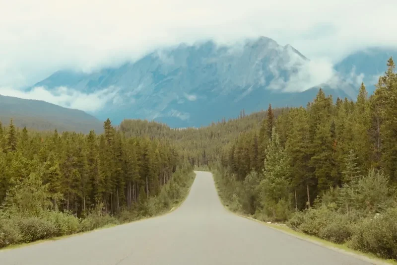
The Skyline Trail is not a walk to be taken lightly. Physical fitness is paramount, as you will be carrying a full multi-day pack over steep, rocky terrain at high altitudes where oxygen is thinner. Before booking, ensure you are comfortable with 15–20 km days and significant elevation changes. Logistics are the next major hurdle. Since the trail is point-to-point, you must arrange transport. Most hikers park at the Signal Mountain trailhead (the finish) and take a pre-booked shuttle to Maligne Lake (the start). This ensures your car is waiting for you when you finish. Companies like Maligne Adventures operate daily shuttles during the hiking season.
Jasper is the base town for this trail. It is a full-service mountain community with grocery stores, outdoor gear shops (for fuel and last-minute supplies), and a wide range of accommodation. It is highly recommended to spend at least one night in Jasper before your hike to acclimatise and double-check your gear. The Jasper Information Centre is the place to pick up your physical permit and get the latest updates on trail conditions, bear sightings, and weather warnings.
Trail Accommodation
Accommodation on the Skyline Trail consists of designated backcountry campgrounds managed by Parks Canada. Wild camping is strictly prohibited to protect the fragile alpine environment. There is also one private lodge, Shovel Pass Lodge, which offers a more comfortable (and expensive) alternative.
Campground Facilities:
- Designated dirt or wooden tent pads (to prevent soil erosion)
- Metal bear lockers or high cables for food storage (mandatory use)
- Green throne-style pit toilets (bring your own toilet paper)
- Grey water pits for disposing of cooking water
- Shared picnic tables at most sites
- Water sources are nearby creeks or lakes (must be treated)
What Campgrounds Don't Provide:
- Shelters or huts (you must bring your own tent)
- Cooking fuel or stoves
- Trash cans (you must pack out all rubbish)
- Cell phone service or electricity
Shovel Pass Lodge: This historic lodge offers catered meals and bunk-style accommodation. It must be booked separately and well in advance. It is located near the junction to Curator Campground and provides a roof over your head for those who prefer not to carry a tent and stove.
Required Gear
- Sturdy hiking boots - Waterproof and well-broken-in. The terrain is rocky and often muddy.
- Backpacking pack - 50–70L with a proper suspension system and rain cover.
- Four-season tent - Even in summer, high winds and snow are possible on the Skyline.
- Sleeping bag - Rated to at least -5°C. Alpine nights are cold.
- Sleeping pad - Essential for insulation from the cold ground.
- Bear spray - Non-negotiable. Must be carried in a holster on your belt or chest strap.
- Navigation - Topographic map and compass (and the knowledge to use them). GPS is a helpful backup.
- Headlamp - With extra batteries.
- Multi-tool or knife - For gear repairs and food prep.
What to Bring
- High-calorie food - Lightweight, dehydrated meals are best. Bring one extra day's worth of food.
- Water treatment - A high-quality filter (like a Sawyer Squeeze or Katadyn BeFree) or purification tablets.
- Layered clothing - Merino wool base layers, a fleece or down mid-layer, and a high-quality waterproof/breathable shell.
- Sun protection - SPF 50+ sunscreen, polarized sunglasses, and a wide-brimmed hat. The UV is intense at 2,500 m.
- First aid kit - Include blister pads (moleskin), antiseptic wipes, and any personal medications.
- Trowel and toilet paper - For use between campgrounds (though you should use the pit toilets whenever possible).
- Cooking system - Lightweight stove (Jetboil or MSR Pocket Rocket) and enough fuel for the duration.
- Personal items - Biodegradable soap, toothbrush, and a small pack towel.
Permits
Securing a permit for the Skyline Trail is notoriously difficult. Parks Canada uses a centralised online reservation system, and spots for the entire summer season typically sell out within minutes of the system opening. For the 2025 season, reservations usually open in late January or early February. You must have a specific itinerary in mind, including which campgrounds you will stay at each night, before you log on to book.
Booking Strategy:
- Create your Parks Canada account weeks before the reservation launch date.
- Be online and logged in at least 15 minutes before the system opens (usually 8:00 AM Mountain Time).
- Have multiple backup dates and campground configurations ready. If Snowbowl is full, try starting a day later or staying at Little Shovel instead.
- The system allows you to book for a group, but you will need the names and details of all participants.
- Payment is required in full at the time of booking via credit card.
Permit Costs:
- Backcountry Camping Fee: Approximately $13.50 per person, per night.
- Reservation Fee: Approximately $11.50 per booking (non-refundable).
- National Park Entry Fee: You must also have a valid Parks Canada Discovery Pass or daily entry pass for Jasper National Park.
Cancellations: If you fail to get a permit during the initial rush, do not give up. Check the Parks Canada reservation website daily, especially in the weeks leading up to your desired dates. Cancellations do happen, and spots are immediately released back into the system. There are also third-party "cancellation tracker" websites that can alert you when a spot becomes available.
Other Activities in the Area
Jasper National Park is a vast wilderness with endless opportunities for adventure. Consider adding these experiences to your trip:
- Maligne Lake Cruise: Before or after your hike, take the famous boat tour to Spirit Island, one of the most photographed spots in the Canadian Rockies.
- Miette Hot Springs: The perfect way to soothe sore muscles after 44 km of hiking. These are the hottest natural springs in the Rockies, cooled to a comfortable 40°C.
- Jasper SkyTram: For those who haven't had enough of high altitudes, the SkyTram takes you to the top of Whistlers Mountain for views of Mount Robson, the highest peak in the Canadian Rockies.
- Valley of the Five Lakes: A beautiful, relatively flat day hike near the Jasper townsite featuring five stunningly coloured lakes.
- Whitewater Rafting: The Athabasca and Sunwapta Rivers offer everything from gentle scenic floats to heart-pounding Class III rapids.
- Dark Sky Preserve: Jasper is one of the world's largest Dark Sky Preserves. Spend an evening at Pyramid Lake for world-class stargazing and a chance to see the Northern Lights.
Safety and Conditions
Wildlife Safety: Jasper is prime Grizzly and Black Bear habitat. The Skyline Trail passes through several "core" bear areas. You must carry bear spray in an accessible location (not inside your pack) and know how to use it. Make noise while hiking, especially in dense brush or near rushing water, to avoid surprising a bear. Store all food, toiletries, and trash in the provided bear lockers at every campground. Never eat inside your tent.
The Notch and Ridge Weather: The section between Curator and Tekarra is the most dangerous part of the trail. The Notch is a steep climb that can be covered in slick snow or ice even in August. High winds on the ridge can exceed 80 km/h, making it difficult to stand. If visibility is poor (fog or "whiteout"), navigation on the ridge becomes extremely difficult as there are few landmarks. If a storm is approaching, do not attempt The Notch; wait it out at Curator or descend to the safety of the trees.
Hypothermia: Even in July, temperatures can drop below freezing. Wet clothing combined with wind on the exposed ridges is a recipe for hypothermia. Always carry a dry set of base layers in a waterproof dry bag and put on your rain gear before you get wet, not after.
Water Safety: While water is plentiful in the valleys, it must be treated. Giardia (beaver fever) is present in the Canadian Rockies. Use a filter, UV purifier, or boiling method for all water collected from streams or lakes.
Emergency Communication: There is no cell phone service on 95% of the Skyline Trail. Carrying a satellite messenger (like a Garmin inReach or Zoleo) is highly recommended for summoning help in an emergency. Always leave a detailed trip plan with a trusted friend or family member.
Side Trips and Points of Interest
Signal Mountain Lookout: On the final day, a short 1.5 km (return) detour from the main trail leads to the old Signal Mountain fire lookout. From here, you get a bird's-eye view of the Jasper townsite, the winding Athabasca River, and the massive peaks of the Victoria Cross Range. It is the perfect place to reflect on your journey before the final descent.
Wabasso Lake Trail: For those staying at Curator Campground, there is an option to exit the trail via the Wabasso Lake route instead of continuing to Signal Mountain. This is a steeper, more forested descent that ends at the Icefields Parkway. It is less scenic than the full Skyline but can be a useful "escape route" if weather on the ridge is too dangerous.
Watchtower Basin: A spectacular side valley located between Snowbowl and Curator. A side trail leads into this rugged basin, which is surrounded by towering limestone cliffs. It is a great spot for photography and often sees fewer people than the main Skyline route. Note that there is a separate campground in Watchtower if you wish to stay overnight.
Marmot and Pika Spotting: The rock piles (talus slopes) along the high ridges are home to Hoary Marmots and American Pikas. Listen for the high-pitched "whistle" of the marmot or the "eep" of the pika. These hardy alpine mammals are a highlight of the trail's fauna.
Leave No Trace
The alpine tundra of the Skyline Trail is one of the most fragile ecosystems on Earth. A single footprint off-trail can destroy plants that have taken decades to grow in the short summer season. As a visitor to this UNESCO World Heritage site, you have a responsibility to minimise your impact.
Core Principles for the Skyline:
- Stay on the Trail: Even if the trail is muddy or snow-covered, do not walk on the surrounding vegetation. Walk through the mud or stay on the rocks.
- Pack It In, Pack It Out: This includes all food scraps (even "biodegradable" ones like orange peels), feminine hygiene products, and micro-trash.
- Respect the Bear Lockers: Use them for everything with a scent, including toothpaste, sunscreen, and lip balm. This prevents bears from becoming "habituated" to human food, which usually results in the bear being destroyed.
- Proper Waste Disposal: Use the provided pit toilets at campgrounds. If you must go between sites, dig a "cathole" at least 15 cm deep and 70 metres away from water sources. Pack out your toilet paper.
- No Campfires: Fires are strictly prohibited on the Skyline Trail. Use a lightweight backpacking stove for all cooking.
- Leave What You Find: Do not pick wildflowers or remove rocks or fossils. Take only pictures, leave only footprints.