Skye Trail (Day Section) - A Journey Through Scotland’s Geological Masterpiece
The Skye Trail is an unofficial but world-renowned long-distance route that traverses the length of the Isle of Skye, stretching approximately 128 kilometres from the northernmost tip at Rubha Hunish to the southern village of Broadford. While the full trail is a demanding week-long expedition, this specific 12-kilometre day section—focussing on the dramatic Trotternish Ridge and the Quiraing—represents the absolute pinnacle of Scottish highland scenery. This section is not merely a walk; it is a passage through a landscape that feels fundamentally ancient, where the earth has been torn, slumped, and sculpted by prehistoric forces into a series of basalt pinnacles, hidden plateaus, and sheer cliffs that defy conventional geography.
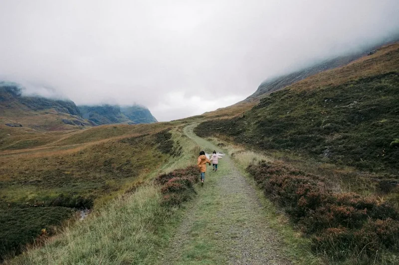
Located in the northern part of the island, this day walk captures the essence of the "Misty Isle." It offers walkers an immersive experience in the Trotternish Landslip, the largest of its kind in the United Kingdom. The route is characterised by its lack of formal waymarking, demanding a level of self-reliance and navigational competence that distinguishes it from more manicured trails in the south of Britain. Here, the path is often a mere suggestion amongst the grass and scree, leading adventurers past iconic landmarks such as The Needle, The Prison, and The Table. For those seeking the raw, unadulterated beauty of the Inner Hebrides, this section of the Skye Trail provides a concentrated dose of drama, challenge, and ethereal light that has inspired poets, filmmakers, and explorers for centuries.
- Distance: 12.0 km (Point-to-point or circuit options)
- Duration: 4–6 hours
- Elevation Gain: 600 m
- Difficulty: Moderate (Requires good fitness and navigational skills)
- Best Time: April to September (to avoid the shortest days and harshest winter gales)
- Closest Town: Portree (approx. 30 minutes by car)
- Trailhead: Quiraing Car Park or Flodigarry
Overview
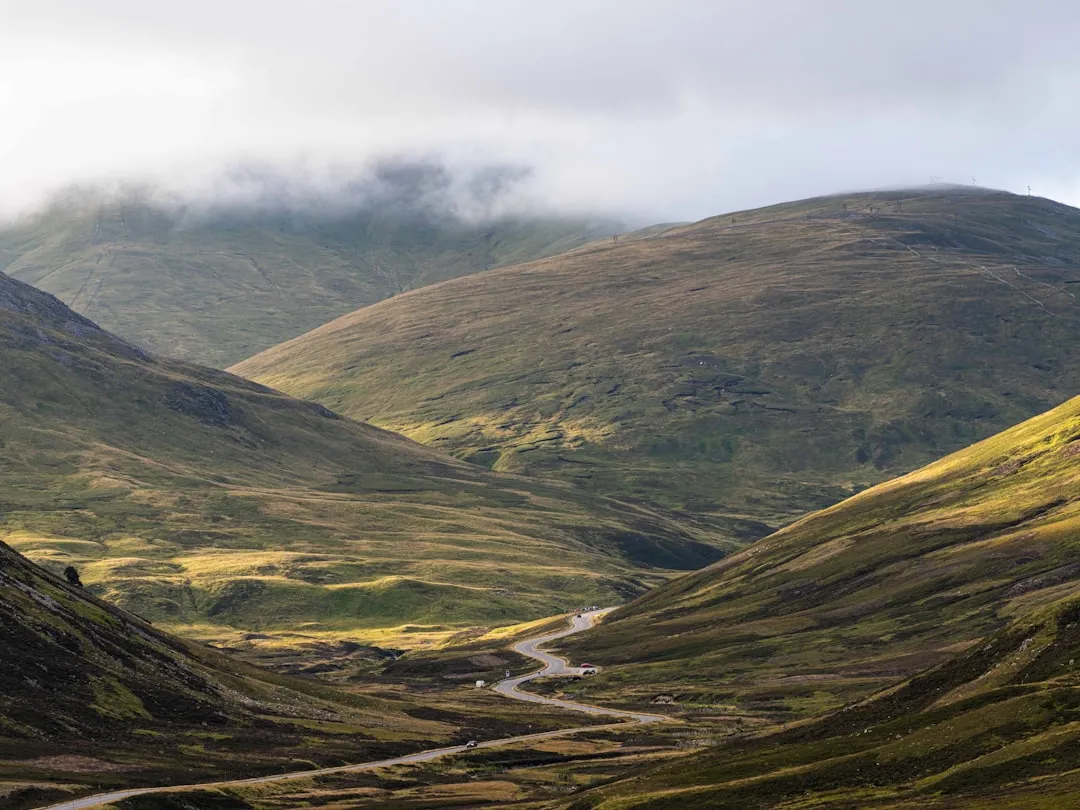
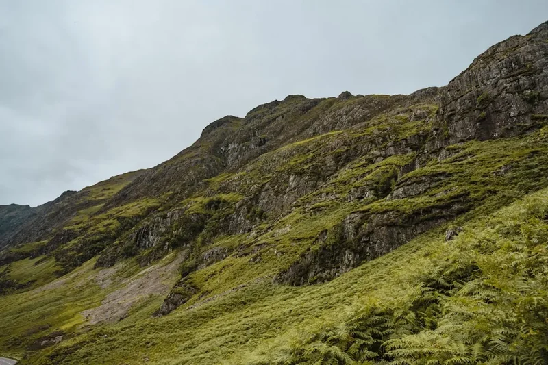
The Trotternish Ridge, which forms the backbone of this day walk, is a geological phenomenon of global significance. Formed by a series of massive landslips where heavy basaltic lava flows overthrew weaker Jurassic sedimentary rocks, the landscape has literally slid toward the sea, creating a jagged, stepped profile that is unique in the British Isles. This 12-kilometre section focuses on the Quiraing, a name derived from the Old Norse 'Kvi Rand', meaning 'Folded Round'. It is a place where the earth seems to be in a state of arrested motion, with massive blocks of stone standing like sentinels over the Sound of Raasay.
Walking this section provides a masterclass in Hebridean topography. The route begins with a steady ascent that quickly leaves the coastal greenery behind, ascending into a realm of grey stone and vibrant emerald moss. The scale of the cliffs is difficult to grasp until you are standing beneath them; the basalt walls rise hundreds of metres vertically, often shrouded in the "smirr"—a fine, Scottish mist that can appear and disappear in a matter of minutes. This constant interplay of light and shadow creates a photographic paradise, where the landscape transforms from a brooding, dark fortress into a sun-drenched emerald kingdom within the space of a single afternoon.
Unlike many popular trails, this section of the Skye Trail maintains a sense of wildness. There are no visitor centres on the ridge, no paved walkways, and very few signposts. The experience is one of genuine connection with the elements. Walkers must be prepared for the "four seasons in one day" reality of Scottish weather, where a calm morning can transition into a buffeting gale by midday. However, the reward for this unpredictability is a sense of solitude and grandeur that is increasingly rare in modern hiking. Whether you are gazing out toward the Outer Hebrides on a clear day or watching the clouds swirl through the rock pinnacles, the Quiraing section of the Skye Trail offers a profound sense of perspective on the natural world.
History and Cultural Context
The history of the Isle of Skye is as layered and dramatic as its geology. The Trotternish peninsula, where this trail is located, has been inhabited for millennia, with evidence of Mesolithic hunter-gatherers and Neolithic farmers scattered across the island. However, the cultural identity of the region is most strongly defined by its Norse-Gaelic heritage. From the 9th to the 13th centuries, Skye was part of the Kingdom of the Isles, a Norse maritime empire. The influence of the Vikings remains etched into the landscape through place names; 'Quiraing', 'Flodigarry', and 'Trotternish' all have roots in Old Norse, reflecting a time when these ridges served as vital landmarks for longships navigating the Minch.
In the centuries that followed, the land became the territory of the powerful Clan MacDonald of Sleat. The Quiraing itself served a very practical historical purpose: its hidden plateaus and "folded" geography provided the perfect sanctuary for concealing cattle from raiding parties. The "Table," a flat, grassy plateau hidden amongst the pinnacles, was famously used to hide livestock during times of conflict, as it is virtually invisible from the valleys below. This tradition of the landscape as a fortress is a recurring theme in Skye’s history, where the rugged terrain offered protection to those who knew its secrets.
The 18th and 19th centuries brought a darker chapter to the region with the Highland Clearances. Many small crofting communities in the shadow of the Trotternish Ridge were forcibly removed to make way for large-scale sheep farming. As you walk the lower sections of the trail, you may notice the "lazy beds"—ancient ridge-and-furrow patterns in the soil where crofters once grew potatoes—and the ruins of stone dwellings. These silent witnesses tell a story of a displaced population and a changing way of life. Today, the Skye Trail is part of a modern effort to celebrate this heritage, connecting the abandoned villages with the thriving Gaelic culture that still exists in Portree and the surrounding townships. The trail is not just a physical path; it is a thread through the history of a resilient people and a restless landscape.
Want more background? Read extended notes on history and cultural context → Learn more
Seasonal Highlights and Weather Reality
The Isle of Skye is famous for its volatile weather, and the Trotternish Ridge is particularly exposed to the Atlantic systems. Understanding the seasons is crucial for a safe and enjoyable walk.
Spring (April to May): Many experienced walkers consider this the best time to visit. The days are lengthening, the weather is often more stable than in mid-summer, and the infamous Scottish midges have not yet emerged. The landscape is a vibrant green, and the air is exceptionally clear, offering the best views across to the mountains of Wester Ross on the mainland. However, snow can linger on the higher parts of the ridge well into April, and temperatures can remain near freezing at night.
Summer (June to August): This is the peak tourist season. The weather is at its warmest, with temperatures occasionally reaching 20°C, though 14–16°C is more common. The main challenge in summer is the Highland Midge—tiny biting insects that can be extremely bothersome on calm, damp days. Additionally, the trail can become busier, particularly around the Quiraing car park. The benefit of summer is the incredible "Simmer Dim"—the long twilight where it never truly gets dark, allowing for very long days on the hill.
Autumn (September to October): As the heather turns purple and then a deep rusty brown, the landscape takes on a dramatic, moody character. September can offer beautiful, crisp days, but by October, the Atlantic storms begin to roll in with greater frequency. Rainfall increases significantly, and the ground can become very boggy. This is a season for experienced walkers who enjoy the atmosphere of a brooding highland landscape.
Winter (November to March): This is a serious undertaking. The Trotternish Ridge becomes an alpine environment, requiring ice axes, crampons, and high-level winter navigation skills. Daylight is extremely limited (as little as 6 hours in December), and gales can reach speeds that make standing upright impossible. While the ridge is breathtaking under a coat of snow, it should only be attempted by those with significant winter mountaineering experience.
Recommended Itinerary
The Quiraing Circuit (Day Section)
08:30 – 09:00: Arrival and Preparation
- Start at the Quiraing Car Park (located on the minor road between Uig and Staffin).
- Ensure all waterproofs are accessible; even if the sun is shining, the ridge creates its own microclimate.
- Check the compass bearing for the initial path heading north-east.
- Take a moment to view the "Prison" from the car park—a massive rock formation that resembles a medieval keep.
09:00 – 10:30: The High Path to the Needle
- Follow the well-trodden but narrow path that traverses the steep slopes beneath the main cliff line.
- Distance: 2.5 km.
- Elevation: Gradual ascent with some rocky steps.
- Key Waypoint: The Needle. This 37-metre-high jagged pinnacle is a landmark of the Quiraing. The path passes directly beneath it.
- The views to the right open up over the village of Staffin and the islands of the Sound of Raasay.
10:30 – 12:00: Ascending to The Table
- The route becomes steeper as you scramble up a gully to reach the upper plateau.
- Key Waypoint: The Table. This is a large, flat, grassy area hidden behind the pinnacles. It is an ideal spot for a break, sheltered from the wind.
- Explore the perimeter of The Table for unique perspectives of the rock formations from above.
- Be cautious of the sheer drops on the eastern edge.
12:00 – 13:30: The Ridge Traverse
- From The Table, ascend to the main crest of the Trotternish Ridge.
- Distance: 4 km.
- Elevation: Reaching the high point of the day at approximately 540 metres.
- The walking here is on short grass and can be very exposed to the wind.
- On a clear day, you can see the Outer Hebridean islands of Harris and North Uist to the west.
- The path follows the cliff edge; stay at least 5 metres back from the rim, especially in gusty conditions.
13:30 – 15:00: Descent toward Flodigarry
- The trail begins a long, steady descent toward the north-east.
- The terrain becomes more boggy as you lose elevation.
- Pass through areas of ancient landslip debris, where the ground is hummocky and uneven.
- Key Waypoint: The Lochans. Small, dark pools of water that reflect the towering cliffs above.
15:00 – 16:00: Final Stretch and Return
- The path levels out as it approaches the coastal road near Flodigarry.
- If you have organised a car ferry or are using the local bus, this is the finish point.
- Alternatively, many walkers choose to loop back via the lower path for a 12 km circuit, returning to the Quiraing Car Park.
- The lower path offers a different perspective, looking up at the massive cliffs you previously walked atop.
Important Notes:
- The path is not waymarked; a map (OS Explorer 408) and compass are essential.
- The "smirr" (mist) can reduce visibility to less than 10 metres in seconds.
- The ground is notoriously boggy in the lower sections; waterproof boots with good gaiters are highly recommended.
- There are no facilities (toilets or shops) on the trail itself.
Planning and Bookings
Book Your Trip
Everything you need to plan your journey
Accommodation
Find places to stay near Portree
Flights
Search flights to Portree
Essential Preparation
Preparation for the Skye Trail day section begins with logistics. Portree is the primary hub for the island and serves as the best base for hikers. From Portree, you can access the trailhead via the A87 and then the minor road toward Uig. Parking at the Quiraing is limited and fills up very early (often by 09:00 in summer), so arriving early or using public transport is advised. The Stagecoach 57A/57C bus service runs from Portree to the Quiraing junction, though the schedule is infrequent and requires careful checking.
Fitness requirements are moderate. While 12 kilometres may seem short, the 600 metres of elevation gain and the uneven, often boggy terrain make it feel significantly longer. You should be comfortable walking on steep, rocky ground and have basic navigational skills. There is no mobile phone reception in many of the gullies, so do not rely on Google Maps; download offline maps or, better yet, carry a physical map and compass.
Trail Accommodation
This is a day hike requiring no overnight accommodation on the trail itself. Wild camping is permitted in Scotland under the Scottish Outdoor Access Code, but the Trotternish Ridge is very exposed and finding a flat, sheltered spot can be difficult. Most walkers stay in Portree or the nearby villages of Staffin and Uig.
Accommodation Options in the Area:
- Portree: A wide range of hotels, B&Bs, and a large youth hostel. Booking 4–6 months in advance for summer is essential.
- Staffin: Closer to the trailhead, offering self-catering cottages and a small campsite with basic facilities.
- Flodigarry: Features a historic hotel and a hostel, perfect for those finishing the point-to-point walk.
- Uig: A ferry port with several inns and a campsite, located about 15 minutes from the Quiraing.
Note on Wild Camping: If you choose to wild camp, you must be self-sufficient. There are no facilities, and you must carry out all waste. Avoid camping on the fragile "Table" plateau to preserve its unique ecology.
Required Gear
- Walking Boots: Sturdy, waterproof boots with deep lugs for grip on wet grass and scree. Ankle support is vital for the uneven terrain.
- Waterproof Jacket: A high-quality hardshell (Gore-Tex or similar) with a good hood. Scottish rain is often horizontal.
- Waterproof Overtrousers: Essential for comfort. Wet legs lead to rapid cooling in the wind.
- Navigation: OS Explorer Map 408 (Skye - Trotternish and The Storr) and a reliable baseplate compass.
- Warm Layers: A fleece or synthetic insulated jacket. Even in summer, the ridge-top temperature is significantly lower than at sea level.
- Rucksack: A 20–30 litre pack with a waterproof liner or cover.
- Emergency Whistle: For signalling in low visibility.
- First Aid Kit: Including blister plasters, antiseptic wipes, and a survival bag (bivvy bag).
What to Bring
- Water: At least 2 litres per person. While there are streams (burns), they often run through sheep grazing land; water treatment is necessary if refilling.
- Food: High-energy snacks (nuts, chocolate, dried fruit) and a substantial lunch. There are no food outlets on the ridge.
- Midge Repellent: Smidge or Avon Skin So Soft are the local favourites. A midge head net is a lifesaver if the wind drops.
- Sun Protection: Sunscreen and sunglasses. The Hebridean sun can be surprisingly intense due to the clean air and water reflections.
- Mobile Phone: Fully charged, but kept in a waterproof bag. Consider a portable power bank.
- Head Torch: Even if you plan to be back by afternoon, the mist can make it very dark, and delays are common.
Permits
One of the greatest joys of hiking in Scotland is the Land Reform (Scotland) Act 2003, which established a statutory right of responsible access to most land and water. This means that no permits, fees, or bookings are required to walk the Skye Trail or any of its sections. There are no "gatekeepers" or entry fees for the Quiraing.
The Scottish Outdoor Access Code:
While access is free, it comes with the responsibility to follow the Scottish Outdoor Access Code. This is based on three main principles:
- Respect the interests of others: This includes farmers, crofters, and other trail users. Much of the Trotternish Ridge is active grazing land for sheep.
- Care for the environment: Do not disturb wildlife, and take all litter home.
- Take responsibility for your own actions: The landscape is wild and potentially dangerous. You are responsible for your own safety and must be prepared for the conditions.
Parking and Logistics:
While the trail is free, parking at the Quiraing Car Park is managed by the Highland Council and currently incurs a fee (approximately £5 for 6 hours or £10 for the day). The machines accept card payments, but the signal can be intermittent, so carrying coins is a wise backup. During the height of summer, the car park is often full by mid-morning; if the car park is full, do not park on the verges of the narrow single-track road, as this blocks emergency vehicles and local farm traffic. Instead, consider taking the local bus or starting your walk from the Flodigarry end where parking is slightly easier.
Other Activities in the Area
The Isle of Skye offers a wealth of experiences beyond the Trotternish Ridge. Consider these nearby attractions to round out your trip:
- The Old Man of Storr: Located just south of the Quiraing, this is perhaps the most famous rock formation on the island. A shorter but steeper walk leads to the base of the massive basalt pinnacle.
- The Fairy Pools: Located in Glenbrittle at the foot of the Black Cuillin mountains, these crystal-clear blue pools and waterfalls are perfect for wild swimming (if you can brave the cold).
- Talisker Distillery: Skye’s oldest working distillery, located in Carbost. Take a tour to learn about the production of their famously smoky, maritime single malt whisky.
- Dunvegan Castle: The ancestral home of the Chiefs of Clan MacLeod for 800 years. Explore the castle, its beautiful gardens, and take a boat trip to see the local seal colony.
- Kilt Rock and Mealt Falls: A viewpoint on the coast where basalt columns resemble the pleats of a kilt, and a waterfall plunges 55 metres directly into the sea.
- Portree Harbour: Enjoy a meal of fresh local seafood while watching the colourful fishing boats in the harbour of Skye’s capital.
Safety and Conditions
Navigation and Visibility: The single greatest danger on the Skye Trail is the weather, specifically the "smirr" or thick mountain mist. Because the trail is not waymarked and often consists of multiple sheep tracks, it is incredibly easy to become disoriented. If the mist descends, you must be able to use a map and compass to navigate. Do not follow other walkers blindly; they may be as lost as you are. If visibility drops to near zero and you are unsure of your position, it is often safer to stay put or slowly retrace your steps to a known point rather than wandering toward the cliff edges.
Cliff Edges and Terrain: The Trotternish Ridge is defined by its sheer drops. In high winds, the gusts can be powerful enough to knock a person off balance. Always maintain a safe distance from the edge. The terrain is also notoriously "greasy"—the combination of wet grass and basalt mud is exceptionally slippery. Take extra care on descents, and use trekking poles if you have them to provide extra stability.
Mountain Rescue: In the event of a serious emergency, dial 999 or 112 and ask for "Police" and then "Mountain Rescue." Be prepared to give your location (ideally a six-figure grid reference), the number of people in your party, and the nature of the injuries. Note that mobile signal is very poor in the gullies of the Quiraing; you may need to send someone to higher ground or toward the road to get a signal.
Livestock and Dogs: The ridge is home to thousands of sheep. If you are walking with a dog, it must be kept on a short lead at all times. Ewes can be very protective of their lambs, and sheep can easily be spooked over the cliffs. Farmers are legally entitled to protect their livestock, so please be a responsible dog owner.
Water Safety: While there are many small streams, the presence of sheep means the water may contain harmful bacteria or parasites like Giardia. Always use a filter, purification tablets, or boil the water before drinking.
Side Trips and Points of Interest
The Needle: This 37-metre-high rock pinnacle is the most striking feature of the Quiraing. While it is a popular spot for rock climbers, hikers can walk right to its base. The scale of the rock is immense, and the way the light hits the basalt columns in the late afternoon is spectacular. It is a perfect spot for photography, but be mindful of falling stones from the cliffs above.
The Prison: A massive, three-sided rock formation that, when viewed from certain angles, looks like a medieval fortress. The path winds around its base, offering a sense of being enclosed within a natural stone city. The "walls" of the Prison are home to various nesting birds, including ravens and occasionally golden eagles.
The Table: This is the "hidden" heart of the Quiraing. It is a large, flat, grassy plateau that has slipped down from the main ridge but remained perfectly level. It is surrounded by jagged peaks, making it feel like a secret garden. To reach it requires a short, steep scramble, but the reward is a unique sense of peace and a perspective of the landslip that few casual tourists ever see. It is said that in the past, locals would play shinty (a traditional Scottish sport) on the Table during the summer months.
Flodigarry Lookout: At the northern end of the section, near Flodigarry, there is a small hill that offers a panoramic view back toward the entire Trotternish Ridge. From here, you can see the "stepped" profile of the landslips stretching away into the distance, providing a clear visual of the geological forces that created this landscape.
Leave No Trace
The Isle of Skye has seen a massive increase in tourism in recent years, putting significant pressure on its fragile ecosystems. The Trotternish Ridge is a Site of Special Scientific Interest (SSSI) due to its unique geology and rare alpine flora. It is our collective responsibility to ensure that our presence does not degrade this magnificent landscape.
Core Principles for the Skye Trail:
- Litter: There are no bins on the trail. Everything you bring in—including orange peels, banana skins, and tea bags—must be carried out. These "organic" items take years to decompose in the cold, acidic highland soil and can harm local wildlife.
- Human Waste: If you must go, ensure you are at least 30 metres away from any water source. Dig a hole 15 cm deep and bury your waste. Carry out all toilet paper and sanitary products in a sealed bag.
- Path Erosion: Stay on the main path where possible. Braiding (creating multiple parallel paths) destroys the thin layer of topsoil and leads to massive erosion during heavy rain. If the path is boggy, walk through the mud rather than around it to prevent widening the scar.
- Wildlife: Do not feed the birds or any other animals. Observe from a distance. The Trotternish Ridge is a habitat for golden eagles and white-tailed sea eagles; if you see them, keep your distance and do not use drones, which are highly disruptive to nesting birds.
- Stone Stacks: Do not build "cairns" or stone stacks. Moving stones disturbs the habitat of insects and small mammals and can mislead other hikers who might mistake them for navigational markers.
By following these simple guidelines, you help ensure that the Quiraing remains as wild and beautiful for the next generation as it is today. Leave only footprints, take only photographs.