Skye Trail (Coastal Sections) - A Journey Through the Misty Isle
The Skye Trail is an unofficial, long-distance route that traverses the length of the Isle of Skye, stretching approximately 128 kilometres from the northernmost tip at Rubha Hunish to the southern village of Broadford. Unlike Scotland's more established Great Trails, the Skye Trail is not waymarked, demanding a high level of self-reliance, navigational proficiency, and physical endurance. It is a route of staggering contrasts, taking walkers from the dizzying heights of the Trotternish Ridge—a massive geological landslip of basalt cliffs and pinnacles—to the hauntingly beautiful ruins of cleared villages along the coast. This is a journey through a landscape shaped by volcanic fire, glacial ice, and a complex human history of resilience and displacement. To walk the Skye Trail is to immerse oneself in the raw, unpredictable elements of the Scottish Highlands, where the Atlantic weather dictates the pace and the scenery shifts from emerald-green glens to obsidian-black mountain massifs within a single afternoon.
- Distance: 128.0 km one-way
- Duration: 7–8 days
- Season: April to September (weather dependent; winter requires advanced mountaineering skills)
- Accommodation: Bothies, wild camping, and local B&Bs in villages
- Highest point: The Trotternish Ridge (approx. 720 m at The Storr)
- Total Elevation Gain: 7,600 m
- Difficulty: Challenging (requires navigation and mountain experience)
- Direction: North to south (Duntulm to Broadford) is the traditional route
Overview
The Skye Trail is widely regarded as one of the most spectacular and demanding walks in the United Kingdom. It was first popularised by outdoor writer Cameron McNeish and has since become a bucket-list challenge for experienced trekkers. The trail does not follow a single, continuous path; instead, it links existing footpaths, sheep tracks, and cross-country sections to create a cohesive traverse of the island. Because it lacks official status, there are no signposts or trail markers. Walkers must be adept at reading Ordnance Survey maps and using a compass, particularly when the infamous Skye mist (the "smirr") descends, reducing visibility to a few metres.
The route is traditionally divided into seven or eight stages. The northern sections are dominated by the Trotternish Peninsula, home to the Quiraing and the Old Man of Storr. This area features some of the most photographed landscapes in Scotland, characterised by bizarre rock formations and sheer cliffs that drop into the Minch. As the trail moves south, it passes through the island's capital, Portree, before heading into the heart of the Cuillin mountains. While the trail avoids the technical scrambling of the Black Cuillin ridge, it skirts the base of these formidable peaks, offering breathtaking views of Sgùrr nan Gillean and Bla Bheinn. The final sections follow the coastline of the Strathaird Peninsula, passing through abandoned settlements that serve as a poignant reminder of the Highland Clearances.
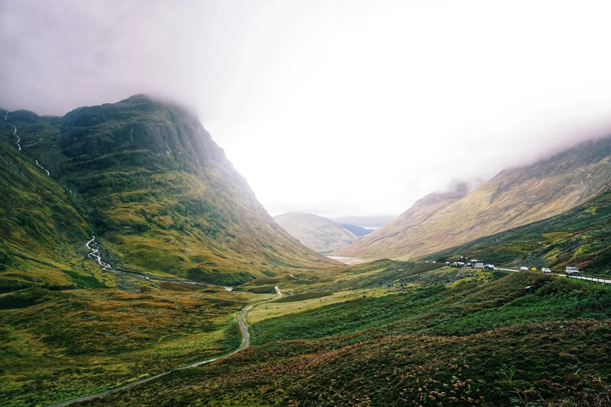
Terrain on the Skye Trail is notoriously varied. Walkers will encounter everything from well-maintained gravel paths and quiet tarmac roads to pathless peat bogs, steep scree slopes, and narrow cliff-edge trails. The "coastal sections" referred to in this guide highlight the trail's unique relationship with the sea. For much of the journey, the Atlantic Ocean is a constant companion, providing a dramatic backdrop of crashing waves, hidden sea caves, and the distant silhouettes of the Outer Hebrides and the Small Isles. The weather is the defining factor of any Skye expedition; the island is famous for experiencing "four seasons in one day," and even in mid-summer, walkers must be prepared for gale-force winds and torrential rain.
History and Cultural Context
The Isle of Skye, or *An t-Eilean Sgitheanach* in Scottish Gaelic, is a land where history is etched into the very stones. The Skye Trail passes through layers of time, from the prehistoric remains of Iron Age duns (forts) to the 19th-century ruins of crofting communities. The island's name likely derives from the Old Norse *Skuy-öy* (Cloud Island), a testament to the Viking influence that dominated the Hebrides for centuries. The Norse-Gaelic culture left a lasting legacy in the island's place names and the ancestral lineages of the powerful clans, most notably the MacLeods and the MacDonalds, whose centuries-long feuds are the stuff of local legend.
One of the most significant and somber aspects of the trail's history is the Highland Clearances (*Fuadach nan Gàidheal*). During the 18th and 19th centuries, thousands of Gaelic-speaking crofters were forcibly evicted from their ancestral lands to make way for large-scale sheep farming. The Skye Trail leads walkers directly through the remains of these "cleared" villages, such as Boreraig and Suisnish on the Strathaird Peninsula. Standing among the roofless stone shells of former homes, overlooking the sea, provides a powerful and moving connection to the people who once lived here. The trail is as much a cultural pilgrimage as it is a physical challenge, offering a window into a way of life that was irrevocably altered by economic and social upheaval.
Geologically, Skye is a masterpiece of natural history. The Trotternish Ridge was formed by a series of massive landslips, where the weight of heavy basaltic lava flows caused the underlying sedimentary rocks to collapse. This created the surreal landscape of the Quiraing and the Storr. Further south, the Cuillin mountains represent the remains of a massive volcanic centre that was active approximately 60 million years ago. The Black Cuillin is composed of gabbro, a rough volcanic rock that provides excellent grip for climbers, while the Red Cuillin is made of granite, giving the hills a smoother, more rounded appearance. Understanding this geological backdrop enhances the experience of the trail, as every climb and descent reveals a different chapter of the Earth's formation.
Want more background? Read extended notes on history and cultural context → Learn more
Seasonal Highlights and Weather Reality
The window for walking the Skye Trail is relatively narrow, dictated by the volatile North Atlantic climate. While the trail is technically open year-round, the conditions between October and March are generally unsuitable for anyone but highly experienced winter mountaineers. During these months, daylight is scarce, temperatures frequently drop below freezing, and the mountains are often covered in snow and ice.
Spring (April to May): Many experienced walkers consider this the best time to tackle the Skye Trail. The weather is often drier than in mid-summer, and the clarity of the air provides exceptional views. The hills begin to turn green, and the absence of the infamous Scottish midge makes camping much more pleasant. However, spring can still bring "winter" conditions to the high ridges, and walkers should be prepared for cold nights and occasional snow showers.
Summer (June to August): This is the peak season for the trail. The days are incredibly long—in late June, it barely gets dark at all—allowing for flexible walking schedules. The wildflowers are in full bloom, and the coastal sections are teeming with birdlife. The major drawback of summer is the midge (*Culicoides impunctatus*). These tiny biting insects can be relentless on calm, damp days, making wild camping a challenge. Summer also brings the highest rainfall, often in the form of heavy Atlantic depressions.
Autumn (September): September offers a beautiful transition as the heather turns purple and the grasses take on a golden hue. The midge population begins to decline with the first frosts, and the tourist crowds in Portree start to thin out. The weather becomes more unpredictable, with a higher frequency of autumn gales, but the light for photography is often at its most dramatic during this month.
Weather Reality: Regardless of the season, you must respect the Skye weather. Rainfall on the island can exceed 2,000 mm annually in the mountains. Wind speeds on the Trotternish Ridge can easily reach 80–100 km/h during storms, making the high-level sections dangerous. Always check the Mountain Weather Information Service (MWIS) forecast specifically for the Northwest Highlands before setting out each day.
Recommended Itinerary
7-Day Skye Trail Itinerary
Day 1: Duntulm to Flodigarry
- Distance: 11 km
- Elevation gain: 350 m
- Time: 3–4 hours
- Start at the ruins of Duntulm Castle, once a seat of Clan MacDonald
- Follow the dramatic coastline of Rubha Hunish, the northernmost point of Skye
- Visit the Lookout Bothy (a former coastguard station) for panoramic views of the Minch
- Descend steep cliffs via a hidden path to the shore
- Arrive in Flodigarry, near the former home of Jacobite heroine Flora MacDonald
- A relatively short day to allow for travel to the trailhead and acclimatisation
Day 2: Flodigarry to The Quiraing (Trotternish Ridge North)
- Distance: 15 km
- Elevation gain: 850 m
- Time: 6–7 hours
- Ascend into the heart of the Quiraing, a surreal landscape of rock pinnacles and hidden plateaus
- Pass landmarks like The Needle, The Prison, and The Table
- Continue south along the high escarpment of the Trotternish Ridge
- Pathless sections require careful navigation in mist
- Wild camp on the ridge or descend to the road for local accommodation
- This is one of the most visually stunning sections of the entire trail
Day 3: The Quiraing to The Storr (Trotternish Ridge South)
- Distance: 18 km
- Elevation gain: 900 m
- Time: 7–9 hours
- The most demanding day of the trail, staying high on the ridge for the duration
- Summit several peaks, including Beinn Edra and Hartaval
- Spectacular views across to the mountains of Wester Ross on the mainland
- Finish at the Old Man of Storr, a 50-metre basalt pinnacle
- Descend to the car park for a bus to Portree or wild camp near the base
- Requires high fitness and good weather; there are few escape routes from the ridge
Day 4: The Storr to Portree
- Distance: 14 km
- Elevation gain: 250 m
- Time: 4–5 hours
- Follow the coastline south from the Storr towards the island's capital
- Pass through forestry plantations and along cliff tops overlooking the Sound of Raasay
- Views of the Isle of Raasay and its distinctive flat-topped hill, Dun Caan
- Arrive in Portree, a vibrant town with colourful harbour buildings
- Excellent opportunity to restock supplies, enjoy a hot meal, and dry out gear
- Mostly downhill or flat, providing a much-needed recovery for the legs
Day 5: Portree to Sligachan
- Distance: 19 km
- Elevation gain: 400 m
- Time: 5–6 hours
- Follow the "Braes" road and coastal paths south of Portree
- Pass the site of the Battle of the Braes, a key event in the crofters' struggle for land rights
- Enter the glens leading towards the Cuillin mountains
- Arrive at Sligachan, home to a famous hotel and the iconic stone bridge
- The Black Cuillin peaks loom large, providing a dramatic change in scenery
- Terrain is a mix of road, track, and potentially boggy moorland
Day 6: Sligachan to Elgol
- Distance: 18 km
- Elevation gain: 500 m
- Time: 6–8 hours
- Walk through Glen Sligachan, flanked by the Black and Red Cuillin
- Pass the beautiful Loch na Creitheach
- Reach the coast at Camasunary Bay, home to a modern bothy and a stunning beach
- Navigate the "Bad Step" (a sloping rock slab over the sea) or take the high bypass route
- Follow the cliff path with incredible views of the Cuillin across Loch Scavaig
- Arrive in the small fishing village of Elgol
Day 7: Elgol to Broadford
- Distance: 28 km (can be split into two days)
- Elevation gain: 650 m
- Time: 8–10 hours
- Traverse the Strathaird Peninsula, passing the ruins of Boreraig and Suisnish
- The path follows the coastline, offering views of the Isle of Rum and Eigg
- Pass through the marble-quarrying area near Torrin
- Final stretch along the old railway track into Broadford
- Celebrate the completion of the trail in Skye's second-largest settlement
- A long final day, but the terrain is generally easier than the northern ridges
Important Notes:
- The Trotternish Ridge (Days 2 and 3) is extremely exposed; do not attempt in high winds
- The "Bad Step" near Elgol is a technical obstacle; it is a 10-metre traverse on a grippy but sloping rock. If you have a heavy pack or a fear of heights, use the bypass
- Navigation is the primary challenge; always carry a physical map and compass
- Water is plentiful in the glens but scarce on the Trotternish Ridge; carry at least 2 litres
- Public transport (Stagecoach buses) connects Portree, Sligachan, and Broadford, but is infrequent in the north
Planning and Bookings
Book Your Trip
Everything you need to plan your journey
Accommodation
Find places to stay near Portree
Flights
Search flights to Portree
Essential Preparation
The Skye Trail is a serious undertaking that requires careful logistical planning. Because it is not an official trail, there is no central booking office or "trail pass." Your primary preparation should focus on navigation and fitness. You should be comfortable walking 20–25 kilometres a day with a full pack (12–15 kg) over rough, pathless terrain. Portree is the main hub for the island and serves as the best base for pre-trail organisation. It has a large supermarket (Co-op), outdoor shops for gas canisters and waterproofs, and a variety of accommodation.
Transport to the start at Duntulm requires taking a bus from Portree. Check the Stagecoach Highlands website for the latest timetables, as services to the far north of the island are limited, especially on Sundays. If you are driving, it is best to leave your car in Broadford or Portree and use the bus to reach the trailhead. Inverness is the nearest major city with an airport and train station, with regular bus links to Skye via the Skye Bridge.
Trail Accommodation
Accommodation on the Skye Trail is a mix of wild camping, bothies, and village-based B&Bs or hostels. There are no dedicated campsites along the Trotternish Ridge or in the remote glens, so self-sufficiency is key.
Bothies: There are two main mountain bothies on the route: The Lookout (Rubha Hunish) and Camasunary (near Elgol). Bothies are basic stone shelters maintained by the Mountain Bothies Association (MBA). They are free to use but offer no facilities—no beds, no heating, and no toilets. You must bring your own sleeping mat and bag. They operate on a first-come, first-served basis and can be very busy in summer. Always have a tent as a backup.
Wild Camping: Under the Scottish Outdoor Access Code, wild camping is legal on most unenclosed land, provided it is done responsibly. This is the most flexible way to experience the trail. Ideal spots include the plateaus of the Trotternish Ridge (if the wind is low) and the coastal flats near Camasunary. Ensure you are at least 100 metres away from roads and buildings.
Villages: Portree, Sligachan, Elgol, and Broadford offer various accommodation options. - Portree: Numerous hostels, B&Bs, and hotels. Booking months in advance is essential for summer. - Sligachan: The Sligachan Hotel and an adjacent bunkhouse and campsite. - Elgol: Limited B&Bs and a small shop; very remote. - Broadford: Hostels, campsites, and B&Bs.
Required Gear
- Navigation - OS Landranger maps (Sheets 23 and 32) or Explorer maps (407, 408, 411), high-quality compass, and GPS with offline maps
- Footwear - Sturdy, waterproof trekking boots with good ankle support and deep lugs for mud and scree
- Waterproofs - A high-spec waterproof jacket and overtrousers (Gore-Tex or similar) are non-negotiable
- Backpack - 50–65L capacity with a waterproof liner or rain cover
- Shelter - A lightweight, wind-stable 3-season tent (must be able to withstand high winds)
- Sleeping System - 3-season sleeping bag (comfort rating 0°C) and an insulated sleeping mat
- Cooking - Lightweight stove (Jetboil or MSR), fuel, and a titanium pot
- Safety - Whistle, survival bag (bivvy), and a small first aid kit including blister plasters
- Lighting - Head torch with spare batteries (essential for bothies)
What to Bring
- Food - 3–4 days of lightweight, high-calorie dehydrated meals. You can restock in Portree and Broadford
- Water Treatment - A filter (like a Sawyer Squeeze) or purification tablets. While Skye water is generally clean, sheep are present everywhere
- Midge Protection - Smidge or DEET-based repellent, and a fine-mesh midge head net (essential for June–August)
- Clothing - Merino wool base layers (stay warm when wet), fleece mid-layer, and a down/synthetic insulated jacket for evenings
- Sun Protection - Sunscreen and sunglasses (the Atlantic glare is strong even when cool)
- Toiletries - Biodegradable soap, trowel for waste, and a "pack-it-out" bag for tissues
- Power - A large capacity power bank (20,000mAh) to keep phones and GPS charged
- Dry Bags - Various sizes to keep all clothing and electronics bone-dry inside your pack
Permits
One of the greatest joys of hiking in Scotland is the Land Reform (Scotland) Act 2003, which established a statutory right of responsible access to most land and water. This means that no permits, fees, or registrations are required to walk the Skye Trail or to wild camp along its route. You do not need to book "slots" or notify any authorities of your plans, though leaving your itinerary with a contact person is a standard safety practice.
The Scottish Outdoor Access Code: While access is free, it is contingent upon "responsible" behaviour. This is governed by three main principles: - Respect the interests of other people (farmers, residents, and other trail users). - Care for the environment (leave no trace, protect wildlife). - Take responsibility for your own actions (be self-sufficient and safe).
Access Restrictions: There are very few restrictions, but walkers should be aware of the deer stalking season (traditionally July to late October). While the Skye Trail mostly follows established routes where stalking is less of an issue than in the deep Highlands, it is always polite to check the "Heading for the Scottish Hills" website if you plan to venture far off the main trail during the autumn months. Additionally, during the lambing season (April–May), it is vital to keep dogs on a short lead and avoid crossing fields with young lambs.
Bothy Etiquette: If using the MBA bothies, you must follow the Bothy Code: only use the bothy for short stays, leave it cleaner than you found it, and ensure all fires are fully extinguished. Bothies cannot be booked; if a bothy is full, you are expected to use your tent.
Other Activities in the Area
If you have extra days on the island or need a break from the trail, Skye offers world-class attractions:
- Talisker Distillery: Located in Carbost, this is Skye's oldest operating distillery. Take a tour to learn about their sea-salty, peaty single malt scotch whisky. Booking in advance is highly recommended.
- The Fairy Pools: Situated at the foot of the Black Cuillin near Glenbrittle, these crystal-clear blue pools and waterfalls are famous for wild swimming (though the water is bracingly cold).
- Dunvegan Castle: The ancestral home of the Chiefs of Clan MacLeod for 800 years. Explore the castle, the gardens, and take a boat trip to see the local seal colony.
- Boat Trips from Elgol: Take the 'Misty Isle' or 'Bella Jane' boat from Elgol into Loch Coruisk. This is the most dramatic way to see the heart of the Black Cuillin without a long hike.
- Neist Point Lighthouse: The most westerly point on Skye, offering incredible sunset views and the chance to spot whales, dolphins, and basking sharks from the cliffs.
- Staffin Dinosaur Tracks: At An Corran beach, you can see genuine dinosaur footprints embedded in the rock at low tide—a reminder of Skye's Jurassic past.
Safety and Conditions
Pre-Departure Checks: The Skye Trail is a remote mountain route. Before you start, you must: - Check the MWIS (Mountain Weather Information Service) forecast for the Northwest Highlands. - Ensure your navigation skills are sharp; "following the person in front" is not a strategy on Skye. - Check for any local alerts regarding bridge closures or path erosion on the Walkhighlands website. - Verify bus times if you are relying on them for escape routes.
Navigation and Visibility: The greatest danger on the Skye Trail is the weather-induced loss of visibility. The Trotternish Ridge is a high, featureless plateau in places, and it is remarkably easy to walk off the edge of a cliff in thick mist. You must be able to use a map and compass to take bearings and follow them accurately. Do not rely solely on a smartphone; batteries fail in the cold, and touchscreens are difficult to use in heavy rain.
Terrain Hazards: - Cliff Edges: Much of the trail follows high escarpments. In high winds, stay well back from the edge, as gusts can be unpredictable. - Bogs: Skye is famous for its "peat hags" and bogs. These can be waist-deep in places. Always test the ground with a trekking pole if it looks suspiciously bright green or watery. - The Bad Step: This is a specific obstacle on the coastal path between Camasunary and Elgol. It is a crack in a sloping rock face over the sea. While not difficult for experienced scramblers, it can be terrifying for those with heavy packs or in wet conditions. There is a high-level bypass over the hill of Am Màm. - River Crossings: After heavy rain, small streams can turn into raging torrents. If a crossing looks dangerous, wait for the water to subside (often only takes a few hours) or find a wider, shallower point upstream.
Hypothermia: Even in summer, the combination of wind, rain, and exhaustion can lead to hypothermia. Carry high-energy snacks and ensure your waterproofs are effective. If you or a companion start shivering uncontrollably or become confused, stop immediately, find shelter, and get into dry clothes and a sleeping bag.
Emergency Services: In an emergency, dial 999 or 112 and ask for "Police" and then "Mountain Rescue." Note that mobile signal is non-existent in many of the glens and on the northern coast.
Side Trips and Points of Interest
Rubha Hunish and the Lookout: At the very start of the trail, don't just rush south. Spend time exploring the headland of Rubha Hunish. The Lookout bothy offers one of the best vantage points in Scotland for whale watching. Minke whales, porpoises, and even orcas are occasionally spotted in the deep waters of the Minch. The descent to the lower "shelf" of the headland is steep but rewards you with a feeling of being at the edge of the world.
The Quiraing "Table": While the trail follows the high ridge above the Quiraing, a short detour into the "labyrinth" below is highly recommended. The Table is a flat, sunken grassy plateau hidden among the pinnacles. Legend has it that locals used to hide cattle here during Viking raids. It is a surreal, quiet spot away from the main tourist path.
Loch Coruisk: When you reach Camasunary (Day 6), you are only a few kilometres from Loch Coruisk, often cited as the most magnificent loch in Scotland. It is a freshwater loch completely encircled by the jagged peaks of the Black Cuillin. You can visit it as a side trip from Camasunary before continuing to Elgol. The scale of the rock walls rising directly from the water is truly humbling.
The Cleared Villages of Boreraig and Suisnish: On the final day, the trail passes through these two abandoned settlements. Take the time to wander among the ruins. Boreraig was once a thriving community of over 100 people before they were evicted in 1853. The pathos of the site, with its beautiful views of the sea contrasted with the evidence of forced removal, is a highlight of the trail's cultural journey.
Leave No Trace
The Isle of Skye is experiencing unprecedented levels of tourism, and the fragile Highland ecosystem is under significant pressure. As a walker on the Skye Trail, you have a moral obligation to minimise your impact. The "wild" feel of the trail is its greatest asset; help preserve it for those who follow.
Core Principles for Skye: - Waste Management: There are no bins on the trail. You must pack out every single piece of litter, including fruit peels and nut shells, which take years to decompose in the cold climate. - Human Waste: If you need to go, do so at least 30 metres from water sources and 100 metres from the trail or bothies. Dig a hole 15 cm deep and bury your waste. Pack out all toilet paper and sanitary products in a sealed bag. - Fire Safety: Never light open fires on the peat. Peat is highly flammable and can burn underground for weeks, causing devastating wildfires. Use a camping stove for all cooking. - Campsite Selection: Avoid camping on fragile machair (coastal wildflower grasslands) or in the middle of archaeological ruins. Use "stealth" camping techniques—arrive late, leave early, and leave no trace that you were ever there. - Wildlife: Skye is home to golden eagles and white-tailed sea eagles. If you see large birds of prey, keep your distance and do not disturb nesting sites. Keep dogs under control at all times to protect livestock and ground-nesting birds.
By following these guidelines, you ensure that the Skye Trail remains a pristine wilderness experience rather than a degraded tourist track.