Isle of Skye Trail - A Journey Through the Misty Isle
The Isle of Skye Trail is an unofficial, long-distance route that traverses the length of one of Scotland’s most iconic islands. Stretching approximately 128.7 kilometres from the northernmost tip at Rubha Hunish to the southern village of Broadford, this trail offers a raw and unfiltered experience of the Inner Hebrides. Unlike the more famous West Highland Way, the Skye Trail is not an officially waymarked path; it is a collection of existing trails, coastal paths, and rugged ridge walks linked together to form a continuous journey. This lack of formal status is precisely what draws experienced hikers to its shores—it demands self-reliance, proficient navigation skills, and a deep respect for the volatile Scottish weather. Over the course of 7 to 8 days, walkers encounter some of the most dramatic geological formations in the United Kingdom, from the gravity-defying pinnacles of the Quiraing to the sheer basalt cliffs of the Trotternish Ridge and the jagged, dark gabbro peaks of the Cuillin mountains.
- Distance: 128.7 km one-way
- Elevation Gain: 7,800 m (cumulative)
- Duration: 7–8 days
- Difficulty: Challenging (requires navigation and high fitness)
- Best Time: April to September (shoulder seasons preferred to avoid midges)
- Closest City: Portree (Skye) or Inverness (Mainland)
- Trailhead Access: Bus from Portree to Flodigarry or Duntulm for the northern start
- Direction: Typically walked North to South (Rubha Hunish to Broadford)
Overview
The Isle of Skye Trail is a masterclass in Scottish wilderness. It is a route of two halves: the northern section is dominated by the spectacular Trotternish Ridge, a massive landslip that has created a landscape of emerald slopes and vertical rock faces. The southern section transitions into a more coastal and mountainous character, winding through abandoned villages that whisper of the island’s turbulent history before culminating in the shadow of the formidable Black Cuillin. With a cumulative elevation gain of 7,800 metres, the trail is deceptively strenuous. While the maximum altitude rarely exceeds 700 metres, the constant "yo-yoing" between sea level and high ridges, combined with the often boggy and pathless terrain, ensures that every kilometre is hard-earned.
The terrain is notoriously varied. Hikers will find themselves balancing on narrow cliff-top paths where the Atlantic wind howls, wading through "Skye gold" (the local term for the ubiquitous, ankle-deep peat bogs), and scrambling over scree slopes. Because the trail is not waymarked, the sense of isolation is profound. You will not find fingerposts pointing the way to the next village; instead, you must rely on your map, compass, and ability to read the landscape. This makes the Skye Trail one of the most rewarding walks in Europe for those who seek a genuine sense of adventure away from the manicured paths of more commercial routes.
The weather is perhaps the most defining characteristic of the experience. Skye is known as the "Misty Isle" (Eilean a' Cheò in Gaelic), and for good reason. Low cloud can descend in minutes, reducing visibility to a few metres and turning a straightforward ridge walk into a navigational challenge. However, when the clouds part, the views are unparalleled. The sight of the Outer Hebrides shimmering on the horizon, the deep blue of the Minch, and the golden light hitting the Old Man of Storr is a spectacle that stays with a walker forever. This is a trail that tests your resolve but rewards you with a landscape that feels prehistoric, powerful, and utterly unique.
History and Cultural Context
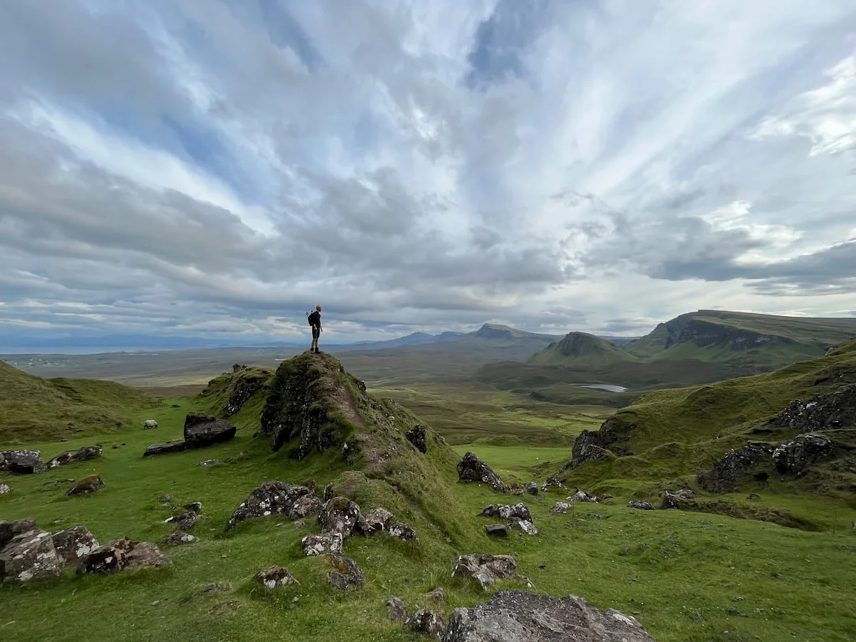
The Isle of Skye Trail is more than just a scenic walk; it is a journey through the layers of Scottish history. The landscape itself is a geological marvel, shaped by intense volcanic activity during the Tertiary period. The Trotternish Ridge, which walkers traverse on Day 2 and 3, is the longest landslip in Britain. This geological instability created the bizarre rock formations like the Needle and the Prison in the Quiraing, which served as natural fortresses and hiding places for cattle during clan raids in centuries past.
Culturally, the trail passes through the heart of the Highland Clearances—a dark period in the 18th and 19th centuries when entire communities were forcibly removed from their ancestral lands to make way for sheep farming. On the southern sections of the trail, particularly between Elgol and Broadford, walkers pass through the ruins of Boreraig and Suisnish. These roofless stone cottages stand as silent, haunting monuments to the families who were evicted and forced to emigrate to the New World. Walking through these "ghost villages" provides a somber and essential perspective on the island’s heritage, connecting the natural beauty of the land with the human struggle that shaped it.
The trail also touches upon the legends of the Jacobite Risings. Near Holm, the route passes close to Prince Charlie’s Cave, where Bonnie Prince Charlie is said to have hidden during his flight from government troops after the Battle of Culloden in 1746. The Gaelic language remains a living part of the island's identity, and you will see it reflected in the place names: "Beinn" for mountain, "Loch" for lake, and "Rubha" for headland. Understanding these names adds a layer of depth to the navigation, as the language is intimately tied to the topography of the Isle of Skye.
Want more background? Read extended notes on history and cultural context → Learn more
Seasonal Highlights and Weather Reality
Timing is everything on the Isle of Skye. The walking season generally runs from April to September, but each month brings a distinct set of conditions that can fundamentally alter the experience. Unlike the European Alps, the challenge here is not just altitude, but the combination of moisture, wind, and biological factors.
Spring (April to May): Many experienced hikers consider this the "Golden Window." These months are statistically the driest on Skye. The air is crisp, the visibility is often excellent, and the hills begin to turn from winter brown to vibrant green. Crucially, this is before the arrival of the Highland Midge. However, snow can still linger on the higher ridges of the Trotternish and the Cuillin, and temperatures can drop below freezing at night.
Summer (June to August): This period offers the longest daylight hours—at the height of June, it barely gets dark at all, allowing for massive days on the trail. However, this is also "Midge Season." The Highland Midge is a tiny biting insect that swarms in the millions on still, damp days. They can make camping or even stopping for a break nearly impossible. Summer also brings the highest rainfall, and the "Skye Mist" can be persistent. If you hike in summer, a midge net and repellent are mandatory items.
Autumn (September to October): September is a beautiful time to walk, as the midges begin to die off and the heather turns a deep purple. The light becomes softer and more golden, perfect for photography. However, the days shorten rapidly, and the frequency of Atlantic storms increases. By October, the trail becomes a serious undertaking as gales and heavy rain become the norm.
Winter (November to March): The Isle of Skye Trail in winter is an expedition-level challenge. Short daylight hours (as little as 6 hours), extreme winds, and heavy snow on the ridges require full winter mountaineering skills, including the use of ice axes and crampons. Many of the island's smaller businesses and transport links close during this time.
Recommended Itinerary
7-Day Isle of Skye Trail Itinerary
Day 1: Rubha Hunish to Flodigarry
- Distance: 11.5 km
- Elevation gain: 450 m
- Time: 4–5 hours
- Start at the telephone box near Duntulm and head north to Rubha Hunish, the island's northernmost point
- Visit the Lookout bothy (a former coastguard station) for incredible views of the Outer Hebrides
- Follow the dramatic cliff tops of the northern coast
- Pass the ruins of Duntulm Castle, perched precariously on the cliffs
- Arrive in Flodigarry, a small settlement with a hostel and hotel
- A relatively short day to ease into the coastal terrain and test your navigation
Day 2: Flodigarry to The Storr (The Trotternish Ridge)
- Distance: 28.5 km
- Elevation gain: 1,750 m
- Time: 10–12 hours
- The "Big Day": This is the most challenging and spectacular section of the trail
- Ascend the Quiraing, navigating through the Needle, the Table, and the Prison
- Follow the crest of the Trotternish Ridge for over 20 kilometres
- Summit multiple peaks including Bioda Buidhe, Beinn Edra, and The Storr
- Terrain is pathless, grassy, and often boggy with steep drops to the east
- Wild camping on the ridge is common, as there is no accommodation until the end of the ridge
- Requires excellent fitness and clear weather for safety
Day 3: The Storr to Portree
- Distance: 14.5 km
- Elevation gain: 550 m
- Time: 5–6 hours
- Descend from the high ridge past the world-famous Old Man of Storr
- Follow the coastline south towards the island's capital
- Pass the "Lealt Falls" and the dramatic cliffs of Bearreraig Bay
- Walk along the "Cliffs of Holm" with views across the Sound of Raasay
- Arrive in Portree, a bustling town with colourful harbour houses
- Excellent opportunity for a hot meal and resupply at the local supermarkets
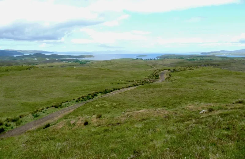
Day 4: Portree to Sligachan
- Distance: 19 km
- Elevation gain: 450 m
- Time: 6–7 hours
- Leave Portree via the coastal path towards the Braes
- Follow the quiet backroads and tracks through the crofting communities of Peinchorran
- Cross the River Sligachan as you enter the heart of the mountains
- The Black Cuillin mountains grow larger in the frame as you approach
- Arrive at Sligachan, famous for its historic hotel, bunkhouse, and iconic stone bridge
- The Sligachan Hotel is a legendary climber's haunt with an extensive whisky collection
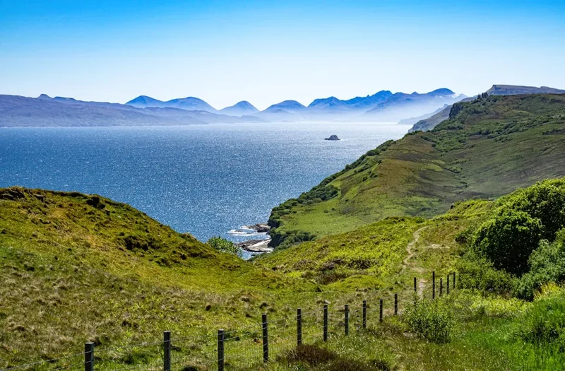
Day 5: Sligachan to Elgol
- Distance: 18.5 km
- Elevation gain: 1,100 m
- Time: 7–8 hours
- Walk through Glen Sligachan, flanked by the Black Cuillin and the Red Hills
- Pass the base of Marsco and Sgùrr nan Gillean
- Reach the shores of Loch na Creitheach
- Cross the pass to Camasunary Bay, home to a remote bothy and a stunning beach
- Follow the coastal path from Camasunary to Elgol, featuring the "Bad Step" (a short, exposed rock scramble)
- Arrive in Elgol, offering the finest view of the Cuillin ridge across Loch Scavaig
Day 6: Elgol to Torrin
- Distance: 16.5 km
- Elevation gain: 1,650 m
- Time: 7–9 hours
- Follow the road and tracks out of Elgol towards the Strathaird peninsula
- Ascend the slopes of Beinn na Caillich or traverse the coastal path around the headland
- Pass through the abandoned clearance villages of Boreraig and Suisnish
- The terrain here is notoriously boggy and requires careful route-finding
- Descend towards the shores of Loch Slapin
- Arrive in Torrin, a small village sitting beneath the massive limestone cliffs of Blà Bheinn
Day 7: Torrin to Broadford
- Distance: 20.2 km
- Elevation gain: 1,850 m
- Time: 8–10 hours
- The final push: Follow the shores of Loch Slapin before heading inland
- Traverse the marble quarries and the rugged moorland of the south
- Ascend the final ridges overlooking the Inner Sound and the mainland mountains
- Pass through the forest plantations on the outskirts of Broadford
- Finish at the pier in Broadford, marking the completion of the 128.7 km journey
- Celebrate with a meal in one of Broadford's pubs before catching a bus or heading to your accommodation
Important Notes:
- The Trotternish Ridge (Day 2) has no water sources on the crest; fill up before ascending
- The "Bad Step" near Camasunary can be bypassed by a higher, steeper route if you have a heavy pack or fear heights
- Public transport on Skye is limited; check Stagecoach bus timetables in advance
- Mobile signal is non-existent in the glens and on much of the northern coast
- Always have a "Plan B" for the ridge sections in case of high winds or low cloud
Planning and Bookings
Book Your Trip
Everything you need to plan your journey
Accommodation
Find places to stay near Portree
Flights
Search flights to Portree
Essential Preparation
The Isle of Skye Trail is an unofficial route, meaning there is no central booking office or "trail permit." Preparation is entirely the responsibility of the walker. The most critical aspect of preparation is navigation. You must be proficient with a map and compass, as the trail is not waymarked and often follows faint sheep tracks or pathless moorland. GPS is a useful tool, but the cold and damp can quickly drain batteries, making paper maps essential backups.
Physically, the trail is demanding. The 7,800 metres of elevation gain is spread across rugged, uneven ground. Training with a weighted pack on hilly terrain is highly recommended. Logistically, you should base yourself in Portree or Broadford for a night before starting. Portree has the best selection of outdoor shops for fuel canisters (which cannot be taken on planes) and last-minute gear. Most hikers fly into Inverness and take the bus or train/bus combination to Skye, which takes approximately 3.5 to 4 hours.
Trail Accommodation
Accommodation on the Skye Trail is a mix of wild camping, bothies, hostels, and B&Bs. Because Skye is a premier tourist destination, indoor accommodation must be booked months in advance, especially for the summer season.
Wild Camping: Under the Scottish Outdoor Access Code, wild camping is legal and is the most flexible way to hike the trail. There are spectacular spots on the Trotternish Ridge and at Camasunary Bay. You must follow "Leave No Trace" principles strictly.
Bothies: There are two MBA (Mountain Bothies Association) bothies on or near the route: The Lookout (Rubha Hunish) and Camasunary. These are basic stone shelters. They provide a roof and a dry floor but no beds, heating, or toilets. They are free to use but cannot be booked and may be full when you arrive.
Hostels and B&Bs:
- Flodigarry: Flodigarry Hostel (popular with hikers)
- Portree: Multiple hostels, hotels, and B&Bs
- Sligachan: Sligachan Bunkhouse and Hotel
- Elgol: Limited B&Bs and a small "Blackhouse" style accommodation
- Broadford: Youth hostel, hotels, and numerous B&Bs
What is NOT provided: Even in hostels, you will often need your own towel. In bothies, you need everything (mat, bag, stove, light). There are no luggage transfer services that cover the entire unofficial route, though some local taxis may assist with specific sections for a high fee.
Required Gear
- Footwear: Sturdy, waterproof trekking boots with good lug depth. The terrain is a mix of sharp rock and deep mud. Trail runners are only recommended for those with very strong ankles and experience in boggy conditions.
- Navigation: OS Landranger maps (8, 23, and 32) or OS Explorer maps. A high-quality baseplate compass and a GPS device with offline maps (e.g., Gaia GPS or OS Maps app).
- Waterproofs: A high-spec waterproof jacket and overtrousers (minimum 20,000mm hydrostatic head). Scottish rain is often horizontal and persistent.
- Shelter: If camping, a high-quality 3-season tent capable of withstanding 60-80 km/h winds. The Trotternish Ridge is extremely exposed.
- Gaiters: Essential for the "Skye Bog." They keep peat and water from entering the top of your boots.
- Midge Protection: A fine-mesh head net and "Smidge" or DEET-based repellent (essential from June to August).
What to Bring
- Food: You need to carry 2-3 days of food at a time. Resupply is possible in Portree (Day 3) and Broadford (Day 7). Sligachan and Elgol have very limited supplies (mostly snacks or pub meals).
- Water Treatment: While Skye’s water is generally clean, much of it flows through peat bogs and sheep grazing land. A lightweight filter (like a Sawyer Squeeze) or chlorine dioxide tablets are recommended.
- Cooking: A lightweight stove (Jetboil or MSR Pocket Rocket). Gas canisters can be bought in Portree or Broadford.
- Power: A large capacity power bank (20,000mAh) to keep phones and GPS charged, as electricity is only available in towns.
- Emergency: A whistle, a survival bag (bivvy), and a small first aid kit including blister plasters (Compeed) and tick removal tweezers.
Permits
One of the greatest joys of hiking in Scotland is the Land Reform (Scotland) Act 2003, which provides a statutory right of responsible access to most land and water. This means you do not need a permit to walk the Isle of Skye Trail, nor do you need permission to wild camp, provided you follow the Scottish Outdoor Access Code.
Key Principles of Access:
- Respect the privacy of others: Do not camp in sight of residential houses or in enclosed fields of crops or livestock.
- Help land managers: During the deer stalking season (July to October), access may be restricted in certain areas for safety. Check the "Heading for the Scottish Hills" website for updates.
- Care for the environment: Do not light open fires; use a stove instead. Peat soil is highly flammable and fires can spread underground.
While the trail itself is free, you should budget for the following costs:
- Transport: Bus fares from Inverness to Skye (approx. £30-£50 return). Local buses on Skye are roughly £5-£10 per journey.
- Accommodation: Hostels range from £25-£40 per night. B&Bs and hotels range from £80-£200+ per night.
- Resupply: Prices in Portree supermarkets are standard UK prices, but small village shops in Elgol or Torrin will be significantly more expensive.
Other Activities in the Area
If you have extra days on the island, Skye offers a wealth of world-class experiences:
- Talisker Distillery: Located in Carbost, this is Skye's oldest operating distillery. Take a tour to learn about their sea-salty, peated single malt whisky.
- The Fairy Pools: Located at the foot of the Black Cuillin, these crystal-clear blue pools and waterfalls are perfect for wild swimming (if you can brave the cold).
- Neist Point Lighthouse: The most westerly point of Skye, offering incredible sunset views and the chance to spot whales, dolphins, and basking sharks from the cliffs.
- Dunvegan Castle: The ancestral home of the Clan MacLeod for 800 years. Explore the gardens and take a boat trip to see the local seal colony.
- Boat Trips from Elgol: Take the "Bella Jane" or "Misty Isle" boat across Loch Scavaig to Loch Coruisk, a freshwater loch in the heart of the Cuillin mountains.
- The Fairy Glen: A bizarre and beautiful miniature landscape of conical hills and lochans near Uig, often described as looking like a film set.
Safety and Conditions
Navigation and Visibility: The single greatest danger on the Skye Trail is the weather. Low cloud (the "Skye Mist") can reduce visibility to near zero in minutes. On the Trotternish Ridge, this is particularly dangerous due to the sheer cliffs on the eastern side. You must be able to navigate using a compass bearing. Do not rely solely on a mobile phone, as the cold and wet can cause electronics to fail.
The "Bad Step": On the section between Camasunary and Elgol, the path encounters a sloping rock face known as the Bad Step. While not a technical climb, it is an exposed scramble over deep water. In wet or windy conditions, it can be slippery and intimidating. If you are uncomfortable, there is a bypass route that climbs steeply over the shoulder of the hill above the step.
Bog and Terrain: Much of the trail is pathless. Walking through deep peat bogs is exhausting and can lead to leg fatigue and twisted ankles. Always use trekking poles to test the depth of the mud before stepping. Hypothermia is a year-round risk in Scotland; even in summer, a combination of wind and rain can drop body temperatures rapidly. Always carry a high-quality survival bag.
Emergency Services: In an emergency, dial 999 or 112 and ask for "Police" and then "Mountain Rescue." Be prepared to give your exact location (OS Grid Reference or What3Words). Note that mobile signal is very poor in the glens.
Side Trips and Points of Interest
The Lookout Bothy: Located at Rubha Hunish, this former coastguard station is one of the most unique shelters in the UK. It features large windows for whale watching and is a perfect spot to spend your first night or wait out a storm. It is maintained by the Mountain Bothies Association.
The Quiraing: While the trail passes through it, taking an extra hour to explore the "Table"—a flat, hidden grassy plateau tucked behind the rock pinnacles—is highly recommended. It was historically used to hide cattle from Viking raiders.
Loch Coruisk: If you have an extra day at Sligachan or Elgol, a trip to Loch Coruisk is essential. Surrounded by the jagged peaks of the Black Cuillin, it is often cited as the most dramatic and "savage" landscape in the British Isles. It can be reached by a long walk-in from Sligachan or a boat from Elgol.
Boreraig and Suisnish: Take time to walk among the ruins of these villages on Day 6. Look for the "lazy beds"—ancient ridges in the soil where the villagers once grew potatoes. The sense of history here is palpable and provides a necessary context to the empty landscapes you traverse.
Leave No Trace
The Isle of Skye’s ecosystem is fragile. The increase in tourism has put significant pressure on the island’s infrastructure and environment. As a walker, you have a responsibility to minimise your impact.
Specific Skye LNT Guidelines:
- Human Waste: In the rocky and boggy terrain of Skye, burying waste can be difficult. If you cannot dig a hole 15 cm deep (at least 30 metres from water), you must pack out your waste using a "poo bag" system. Never leave toilet paper or wipes on the trail.
- Peat Bogs: Avoid creating new paths through the bogs. While it’s tempting to walk around the mud, this widens the trail and destroys more vegetation. Walk through the mud if you have waterproof boots.
- Wild Camping: Use a stove, never an open fire. Peat fires can burn underground for weeks and are nearly impossible to extinguish. Pitch your tent on durable ground and move it every night to prevent "yellowing" the grass.
- Litter: Pack out everything, including orange peels, banana skins, and tea bags, which take years to decompose in the cold Scottish climate.