Six Foot Track - Blue Mountains Wilderness
The Six Foot Track is a historic 45-kilometre, three-day walking track traversing the rugged beauty of the Blue Mountains National Park, west of Sydney, Australia. This iconic trail connects the charming mountain town of Katoomba to the Jenolan Caves, one of the world's most spectacular limestone cave systems. The track winds through diverse landscapes, from dense eucalyptus forests and fern-filled gullies to open heathlands and dramatic escarpments, offering a genuine wilderness experience within easy reach of the city.
Originally established in the 1880s as a more direct route to the caves, the Six Foot Track has evolved from a rough bridle path into a well-maintained but challenging walking trail. It demands a good level of fitness and preparedness, rewarding walkers with stunning vistas, the sounds of native birds, and the profound sense of accomplishment that comes from completing a multi-day trek through a World Heritage-listed area.
- Distance: 45.0 km one-way
- Duration: 3 days / 2 nights
- Season: Autumn and Spring (March-May & September-November)
- Accommodation: Campgrounds at Black Range and Coxs River
- Highest point: Approximately 1100 m (near Katoomba)
- Lowest point: Approximately 600 m (Coxs River)
- Direction: West to East (Katoomba to Jenolan Caves)
- Difficulty: Moderate to Hard (due to distance, elevation changes, and remoteness)
Overview
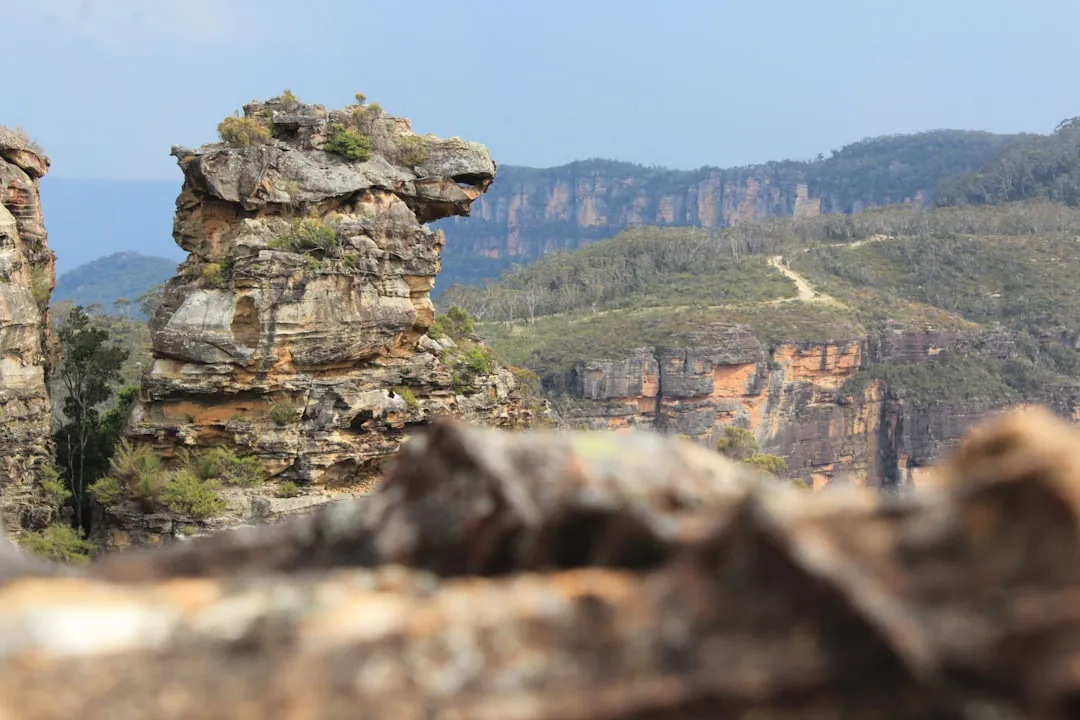
The Six Foot Track offers a compelling journey through the heart of the Blue Mountains, a region renowned for its dramatic sandstone cliffs, deep gorges, and unique flora and fauna. The trail's name originates from its initial construction as a six-foot-wide track, intended for horse-drawn carriages and riders, a testament to its historical significance as a vital link to the Jenolan Caves.
The walk begins in the bustling tourist hub of Katoomba, a town famous for the Three Sisters rock formation and its vibrant arts scene. From here, the track quickly plunges into the wilderness, descending steeply into the Jamison Valley. This initial descent is a significant challenge, testing the knees and quads of even experienced hikers. The path then follows the Coxs River, a picturesque waterway that carves its way through the landscape, offering opportunities for rest and reflection.
The second day involves a substantial climb out of the Coxs River valley, leading walkers towards the Black Range. This section is characterised by open forest and heath, with expansive views opening up as you gain elevation. The air here is often crisp and clean, filled with the scent of eucalyptus. The trail then continues towards the Jenolan Caves area, with the final day involving a shorter but still engaging walk to the cave entrance.
Throughout the trek, walkers can expect to encounter a rich diversity of plant life, including towering eucalypts, delicate ferns, and colourful wildflowers, depending on the season. The sounds of native birds—such as the kookaburra, lyrebird, and various honeyeaters—are a constant companion. While the track is generally well-marked, its remoteness and the potential for challenging weather conditions mean that preparedness is paramount. The Six Foot Track is more than just a walk; it's an immersion into the wild, untamed spirit of the Blue Mountains.
History and Cultural Context
The Six Foot Track's history is intrinsically linked to the development of tourism and exploration in the Blue Mountains during the late 19th century. As the railway line pushed westwards from Sydney, Katoomba emerged as a popular destination, and the desire to access the newly discovered and increasingly famous Jenolan Caves grew. The existing routes were arduous and time-consuming, often involving long horse-drawn coach journeys over rough terrain.
In the 1880s, a concerted effort was made to create a more direct and accessible route. The track was initially conceived and constructed as a six-foot-wide bridle track, designed to accommodate horse-drawn vehicles and riders. This width was a significant undertaking for the era, requiring considerable labour and engineering to carve through the dense bushland, across steep valleys, and over rugged ridges. The construction was driven by the burgeoning tourism industry, with hotels and businesses in Katoomba keen to attract visitors to the natural wonder of Jenolan Caves.
The track's construction was not without its challenges. The terrain is unforgiving, with steep ascents and descents, and the need to bridge or ford the Coxs River presented significant engineering hurdles. Despite these difficulties, the track was completed, providing a vital link that facilitated the growth of tourism to Jenolan Caves. For many years, it was a popular route for both adventurous travellers and those seeking a more direct way to experience the region's natural beauty.
Over time, as road access to Jenolan Caves improved, the Six Foot Track saw a decline in its use as a primary transport route. However, it remained a cherished destination for bushwalkers and nature enthusiasts. In recent decades, there has been a renewed appreciation for the track's historical significance and its value as a multi-day hiking experience. Efforts have been made to maintain and improve the track, ensuring its preservation while allowing walkers to experience the same landscapes that captivated explorers and tourists over a century ago. The track is also situated within the Greater Blue Mountains World Heritage Area, recognising its outstanding universal value and the importance of protecting its natural and cultural heritage.
Seasonal Highlights and Weather Reality
The Six Foot Track experiences distinct seasonal variations, each offering a unique perspective on the Blue Mountains environment. Understanding these differences is crucial for planning a safe and enjoyable trek.
Autumn (March-May): This is widely considered the prime season for walking the Six Foot Track. The weather is typically stable, with mild temperatures, clear skies, and lower humidity. The eucalyptus forests take on a golden hue, and the air is crisp and fresh. Rainfall generally decreases, making river crossings less hazardous. The risk of bushfires is also lower during these months. This season offers excellent visibility for the expansive views from the higher sections of the track.
Spring (September-November): Spring is another excellent time to tackle the Six Foot Track. The bush comes alive with a riot of wildflowers, and the native birdlife is particularly active. Temperatures are generally mild, though can be variable, with cooler mornings and warmer afternoons. There is a higher chance of rain compared to autumn, and occasional strong winds can occur. The track can be muddy in places after rain.
Summer (December-February): Summer on the Six Foot Track can be challenging due to heat and humidity. Daytime temperatures can soar, making strenuous climbs difficult and increasing the risk of dehydration and heatstroke. Bushfire risk is at its highest during this period, and sections of the track may be closed at short notice. While the rainforest gullies offer some shade, exposed sections can be very hot. Thunderstorms are also common in the afternoons, bringing heavy rain and potential flash flooding, particularly along the Coxs River.
Winter (June-August): Winter offers a different kind of beauty, with crisp, clear days and the possibility of frost or even light snow at higher elevations. The landscape can appear stark and dramatic. However, days are shorter, and temperatures can drop significantly, especially at night. Rainfall is common, and river crossings can be more hazardous due to higher water levels. The track can be slippery and muddy. While less crowded, winter requires careful preparation for cold weather and shorter daylight hours.
Weather Reality: The Blue Mountains are known for their unpredictable weather. Even during the best seasons, conditions can change rapidly. Rain can fall at any time of year, and flash flooding along the Coxs River is a significant hazard, especially after heavy rainfall. Always check the weather forecast immediately before your trip and be prepared for a range of conditions, including heat, cold, wind, and rain.
Recommended Itinerary
3-Day Six Foot Track Itinerary
Day 1: Katoomba to Coxs River Campground
- Distance: 15.0 km
- Elevation gain: 400 m (descent), 300 m (ascent)
- Time: 5–7 hours
- Start at Explorers Tree, Katoomba
- Steep descent into the Jamison Valley via the Six Foot Track
- Pass through dense eucalyptus forest and fern gullies
- Cross the historic wooden suspension bridge over the Coxs River
- Arrive at Coxs River Campground
- Set up camp and enjoy the riverside environment
- This day is characterised by a significant downhill section, which can be hard on the knees
Day 2: Coxs River Campground to Black Range Campground
- Distance: 18.0 km
- Elevation gain: 700 m (ascent), 400 m (descent)
- Time: 6–8 hours
- Begin with a steady climb out of the Coxs River valley
- Traverse open eucalypt forest and heathland
- Pass through the small settlement of Megalong Valley (limited facilities, water may be available)
- Continue climbing towards the Black Range
- Arrive at Black Range Campground
- This is the longest and most physically demanding day, with significant elevation gain
- The views from the higher sections can be spectacular on clear days
Day 3: Black Range Campground to Jenolan Caves
- Distance: 12.0 km
- Elevation gain: 200 m (descent), 300 m (ascent)
- Time: 4–5 hours
- Continue through forest and heathland
- The track gradually descends towards the Jenolan Caves precinct
- Pass through areas of striking rock formations
- Arrive at the Jenolan Caves Visitor Centre
- Option to book a cave tour after completing the walk
- This day is generally less strenuous than Day 2, allowing for a more relaxed finish
Important Notes:
- Water sources are available at Coxs River and Black Range campgrounds, but treatment is essential. Water may also be available at Megalong Valley, but this is not guaranteed.
- No food is available along the track; all supplies must be carried.
- Campgrounds have basic facilities: pit toilets and a picnic table. No showers or potable water.
- Bookings for campgrounds are recommended, especially during peak seasons.
- The track is well-marked but can be rough and steep in places.
- Flash flooding is a serious risk along the Coxs River; check conditions before crossing.
Planning and Bookings
Book Your Trip
Everything you need to plan your journey
Accommodation
Find places to stay near Katoomba
Flights
Search flights to Katoomba
Essential Preparation
The Six Foot Track is a multi-day hike that requires careful planning and preparation. Given its remoteness and the potential for challenging conditions, it is essential to be physically fit and well-equipped. The closest major city is Sydney, from which you can travel to Katoomba by train or car. Katoomba is the primary gateway town, offering a range of accommodation, dining, and gear supply options. It's advisable to spend at least one night in Katoomba before starting your hike to finalise preparations and acclimatise.
Logistics for the Six Foot Track involve getting to the start point (Katoomba) and arranging transport from the end point (Jenolan Caves) back to your vehicle or onward travel. Many walkers arrange a shuttle service or a taxi from Jenolan Caves back to Katoomba, or to their parked car if they have arranged for it to be moved. It is also possible to arrange for a car shuffle if hiking with a group.
Trail Accommodation
The Six Foot Track offers basic camping facilities at designated campgrounds. There are no huts or lodges along the route.
- Coxs River Campground: Located approximately 15 km from Katoomba, beside the Coxs River. This is a popular first-night stop.
- Facilities: Pit toilets, picnic tables.
- Water: River water available, must be treated.
- Booking: Recommended, especially during school holidays and weekends. Managed by NSW National Parks and Wildlife Service (NPWS).
- Cost: Typically a small fee per person per night.
- Black Range Campground: Located approximately 33 km from Katoomba, on the Black Range plateau. This is the second-night stop.
- Facilities: Pit toilets, picnic tables.
- Water: Limited water sources may be available, but treatment is essential. It is advisable to carry sufficient water from Coxs River or have a reliable filtration/purification method.
- Booking: Recommended, managed by NPWS.
- Cost: Typically a small fee per person per night.
What's NOT provided: Huts, shelters, showers, potable water, cooking facilities, electricity, mobile phone reception (patchy at best).
Seasonal Availability: Campgrounds are generally open year-round, but conditions can be challenging in winter and summer. Autumn and spring offer the most pleasant camping weather.
This is a multi-day hike requiring overnight camping.
Required Gear
- Sturdy hiking boots: Waterproof, well-worn-in boots with good ankle support are essential for the varied and often rough terrain.
- Backpack: A comfortable pack of 50-65 litres capacity, with a rain cover.
- Tent: A lightweight, waterproof tent suitable for bush camping.
- Sleeping bag: Rated for the expected overnight temperatures (consider a 0°C to 5°C comfort rating for cooler months).
- Sleeping mat: For insulation and comfort.
- Waterproof jacket and overtrousers: Essential for protection against rain and wind.
- Warm layers: Fleece or down jacket, thermal base layers (merino wool is ideal).
- Head torch: With spare batteries, as nights are dark and there is no electricity.
- Navigation tools: Map of the Six Foot Track, compass, and/or GPS device. Mobile phone reception is unreliable.
- First-aid kit: Comprehensive kit including blister treatment, pain relievers, antiseptic wipes, bandages, and any personal medications.
- Sun protection: Wide-brimmed hat, sunglasses, and sunscreen (SPF 30+).
- Insect repellent: Especially important during warmer months for flies and mosquitoes.
What to Bring
- Food: Sufficient non-perishable food for three days (breakfasts, lunches, dinners, snacks). Lightweight, high-energy meals are recommended.
- Water bottles or hydration reservoir: Capacity for at least 2-3 litres per person.
- Water treatment: Water filter, purification tablets, or a UV steriliser. All water from natural sources must be treated.
- Cooking equipment: Lightweight camping stove, fuel, pot, mug, bowl, and eating utensils.
- Toiletries: Biodegradable soap, toothbrush, toothpaste, toilet paper, hand sanitiser.
- Trowel: For burying human waste at least 100 metres from water sources and campsites (if not using designated toilets).
- Rubbish bags: To pack out all waste.
- Trekking poles: Highly recommended for steep descents and ascents, and for river crossings.
- Emergency communication device: Personal Locator Beacon (PLB) or satellite phone is strongly recommended due to unreliable mobile coverage.
- Small towel: Quick-drying microfibre towel.
- Book or journal: For downtime at the campsite.
Permits
While the Six Foot Track itself does not require a specific "walk permit" in the same way as some national parks, you are required to book and pay for camping at the designated campgrounds managed by NSW National Parks and Wildlife Service (NPWS). These fees contribute to the maintenance of the track and facilities.
Campground Booking:
- Booking System: Bookings can typically be made online through the NSW National Parks and Wildlife Service website or by phone. It is highly recommended to book your campsites in advance, especially if you plan to hike during peak seasons (school holidays, long weekends, autumn and spring).
- Fees: A nightly fee applies for each person camping at Coxs River and Black Range campgrounds. These fees are generally modest but can vary. Check the NPWS website for current pricing.
- Registration: While not a formal permit, it is good practice to register your intentions to hike the Six Foot Track with NPWS or a local visitor centre. This helps them monitor visitor numbers and provides a point of contact in case of emergencies.
National Park Entry: The Six Foot Track is located within the Greater Blue Mountains World Heritage Area and is managed by NPWS. While there is no general entry fee for the national park itself, fees apply for specific facilities like campgrounds.
Jenolan Caves: If you plan to visit the Jenolan Caves after your hike, separate entry and tour fees apply. These should be booked in advance directly with Jenolan Caves.
Important Considerations:
- Flexibility: Always have a backup plan. Weather can force track closures or make conditions unsafe.
- Information: Obtain the most up-to-date information on track conditions, campground availability, and any potential closures from the NPWS website or by contacting the local NPWS office before your trip.
Other Activities in the Area
The Blue Mountains and the Jenolan Caves region offer a wealth of activities to complement your Six Foot Track adventure:
- Jenolan Caves Tours: No visit to the area is complete without exploring the magnificent Jenolan Caves. Numerous guided tours are available, showcasing the stunning limestone formations, underground rivers, and the famous Lucas Cave and Imperial Cave. Booking tours in advance is highly recommended.
- Scenic World, Katoomba: Before or after your hike, visit Scenic World in Katoomba to experience the Three Sisters from various viewpoints, ride the Scenic Railway (the world's steepest), the Scenic Skyway, and the Scenic Cableway.
- Hiking in the Blue Mountains: The region is a hiker's paradise with countless day walks. Popular options include the Prince Henry Cliff Walk (connecting Katoomba Falls, Echo Point, and the Three Sisters), the Grand Canyon Track (a challenging loop through a spectacular gorge), and walks around Wentworth Falls.
- Katoomba and Leura Villages: Explore the charming towns of Katoomba and Leura, known for their art galleries, boutique shops, cafes, and restaurants.
- Lookouts: Visit iconic lookouts such as Echo Point, Govetts Leap, and Evans Lookout for breathtaking panoramic views of the Blue Mountains escarpments and valleys.
- Horse Riding: Several operators in the Megalong Valley offer horse riding tours through the scenic countryside, providing a different perspective on the landscape.
- Abseiling and Canyoning: For the more adventurous, guided abseiling and canyoning trips are available in various locations throughout the Blue Mountains.
Safety and Conditions
Pre-Trip Checks:
- Weather Forecast: Always check the latest weather forecast for the Blue Mountains region from the Bureau of Meteorology (BOM) and MetService. Pay close attention to warnings for heatwaves, heavy rain, thunderstorms, and bushfires.
- Track Conditions: Visit the NSW National Parks and Wildlife Service (NPWS) website for any alerts or closures affecting the Six Foot Track. Conditions can change rapidly due to weather or maintenance.
- Bushfire Information: During warmer months, monitor the Rural Fire Service (RFS) website for fire danger ratings and any active fires. The Six Foot Track can be closed at short notice due to bushfire risk.
Key Hazards:
- Steep Terrain: The track involves significant steep ascents and descents, particularly on Day 1 into the Jamison Valley and Day 2 out of the Coxs River valley. This can be hard on knees and ankles, and slippery when wet.
- River Crossings: The Coxs River crossing (via suspension bridge) and other smaller creek crossings can become dangerous or impassable after heavy rain. Always assess the water level and flow before attempting to cross. If in doubt, do not cross.
- Flash Flooding: The Coxs River and its tributaries are prone to flash flooding. Never camp or linger in low-lying areas near the river during or after heavy rainfall.
- Heat and Dehydration: Summer can bring extreme heat. Carry ample water, drink regularly, and consider hiking in the cooler parts of the day.
- Hypothermia: In cooler months, temperatures can drop significantly, especially at night. Ensure you have adequate warm clothing and a suitable sleeping bag.
- Bushfires: Bushfires are a serious risk, particularly in summer and autumn. Be aware of fire danger ratings and closures.
- Navigation: While the track is generally well-marked, it is essential to carry a map and compass and know how to use them. Mobile phone reception is unreliable.
- Wildlife: Be aware of snakes, particularly during warmer months. Keep to the track and wear sturdy footwear. Do not approach or feed wildlife.
Emergency Procedures:
- Mobile Phone Coverage: Coverage is intermittent and unreliable. Do not rely on your mobile phone for emergencies.
- Personal Locator Beacon (PLB): Carrying a PLB or satellite phone is strongly recommended for remote areas like the Six Foot Track.
- Emergency Contacts: Inform a reliable person of your hiking plans, including your intended route, start and end dates, and expected return time.
- In case of emergency: If you need to contact emergency services, try to find a location with mobile reception or use your PLB.
Travel insurance is highly recommended to cover potential medical emergencies, evacuation, and trip cancellations.
Side Trips and Points of Interest
Coxs River Suspension Bridge: A historic and iconic feature of the Six Foot Track, this sturdy wooden suspension bridge spans the Coxs River, providing a safe crossing point. It's a significant landmark and a great spot for photos, offering a sense of the track's historical engineering. The river itself is a beautiful spot to rest and refill water supplies (remember to treat it).
Jenolan Caves: While the end point of the hike, the Jenolan Caves are a major point of interest and a significant geological wonder. The network of limestone caves is one of the most spectacular in the world, with stunning stalactites, stalagmites, and underground rivers. Taking a guided tour after completing the hike is a highly recommended way to experience this natural marvel.
Lookouts near Katoomba: Before or after your hike, take time to visit the famous lookouts around Katoomba, such as Echo Point, which offers iconic views of the Three Sisters rock formation. These provide a dramatic introduction or conclusion to the Blue Mountains landscape you will be traversing.
Megalong Valley: As you traverse the track on Day 2, you will pass through or near the Megalong Valley. This fertile valley is known for its farms and vineyards. While facilities are limited, it offers a glimpse into rural life within the mountains and can be a good spot for a brief rest stop.
Diverse Flora and Fauna: The Six Foot Track passes through a variety of ecosystems, from dense eucalyptus forests to fern-filled gullies and open heathlands. Keep an eye out for native Australian wildlife, including various bird species (kookaburras, lyrebirds, parrots), wallabies, and if you're very lucky, echidnas. The changing vegetation provides a constant visual interest throughout the trek.
Leave No Trace
The Six Foot Track winds through the Greater Blue Mountains World Heritage Area, a region of immense natural beauty and ecological significance. Practising Leave No Trace principles is crucial to preserving this environment for future generations.
Your responsibility as a walker:
- Plan Ahead and Prepare: Know the regulations, carry appropriate gear, and be prepared for varying weather conditions.
- Travel and Camp on Durable Surfaces: Stick to the marked track and camp only in designated campgrounds. Avoid trampling vegetation.
- Dispose of Waste Properly: Pack out everything you pack in, including all food scraps, wrappers, and toilet paper. Use designated toilets where available, or bury human waste at least 100 metres from water sources and campsites.
- Leave What You Find: Do not remove rocks, plants, or any other natural or cultural objects.
- Minimise Campfire Impacts: Campfires are generally not permitted on the Six Foot Track. Use a lightweight camping stove for cooking. If fires are permitted in designated areas (check current regulations), use existing fire rings and ensure fires are completely extinguished.
- Respect Wildlife: Observe wildlife from a distance. Never feed animals, as it can harm their health and alter their natural behaviours.
- Be Considerate of Other Visitors: Keep noise levels down, especially at campgrounds. Yield to other walkers on the track.
By adhering to these principles, you help ensure that the Six Foot Track remains a wild and beautiful place for everyone to enjoy.