Simpson Desert Crossing - The Red Heart of Australia
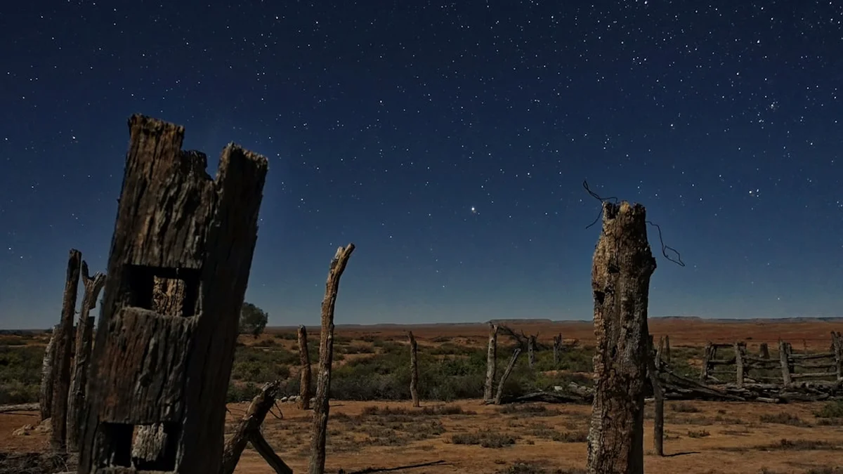
The Simpson Desert Crossing is one of the world's most formidable and evocative remote expeditions—a 400-kilometre journey across the largest parallel sand dune desert on Earth. Spanning the corners of South Australia, Queensland, and the Northern Territory, this crossing is a rite of passage for serious adventurers seeking to test their resolve against a landscape of staggering scale and profound isolation. Known to the Traditional Owners as Munga-Thirri, the desert contains over 1,100 longitudinal sand dunes, some reaching heights of 40 metres, all aligned in a north-northwest to south-southeast direction. This is not merely a trek; it is a deep immersion into a prehistoric arid ecosystem where the silence is absolute, the night skies are unparalleled in their clarity, and the sense of solitude is all-encompassing. The route typically runs from Dalhousie Springs in the west to Birdsville in the east, traversing the French Line, QAA Line, and WAA Line, challenging travellers with soft sand, steep dune faces, and the logistical complexity of total self-sufficiency in a region where help is days away.
- Distance: 400.0 km (approximate, depending on route choice)
- Duration: 10–14 days
- Season: May to September (strictly closed in summer due to lethal heat)
- Accommodation: Remote bush camping (total self-sufficiency required)
- Highest point: Big Red (Nappanerica Dune) ~40 m above surrounding plains
- Difficulty: Very Challenging (requires advanced 4WD skills and remote survival preparation)
- Direction: West to East is recommended (to tackle the gentler slopes of the dunes)
Overview
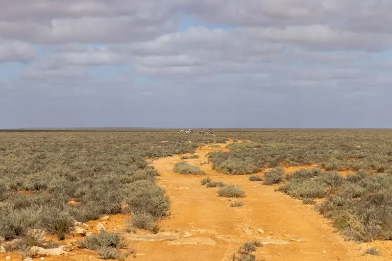
The Simpson Desert is a landscape defined by its geometry and its colour. Covering 176,500 square kilometres, it is a sea of red sand that has been shaped over millennia by prevailing winds into a series of remarkably straight, parallel ridges. For the traveller, the crossing is a rhythmic experience: the slow, low-range crawl up the western face of a dune, the brief moment of panoramic clarity at the crest, and the controlled descent into the swale (the valley between dunes) before the process repeats. This cycle occurs over a thousand times during a full crossing. The sand itself varies from deep ochre to brilliant crimson, a result of iron oxide coating the quartz grains, creating a visual spectacle that shifts dramatically with the angle of the sun.
While often perceived as a barren wasteland, the Simpson is a living desert. The swales are often filled with hardy spinifex grass, gnarled gidgee trees, and, following rare rain events, an explosion of wildflowers that transforms the red dust into a carpet of yellow, white, and purple. The wildlife is equally resilient; travellers may encounter dingoes, camels (introduced but thriving), perentie lizards, and a surprising array of birdlife around the rare bores and salt lakes. The crossing is a masterclass in patience and mechanical sympathy. It demands a slow pace to preserve both the vehicle and the track surface, allowing the immensity of the environment to truly sink in. There are no shops, no permanent settlements, and no reliable water sources between the start and end points. It is a journey that strips away the noise of modern life, leaving only the essentials: navigation, conservation of resources, and the awe-inspiring beauty of the Australian interior.
The most famous landmark of the crossing is Nappanerica, popularly known as "Big Red." Standing as the final and tallest dune before reaching Birdsville, it serves as the symbolic gateway to the desert. Reaching its summit at sunset, looking back over the endless waves of sand you have just conquered, is one of the most iconic experiences in Australian exploration. However, the true essence of the Simpson lies in the middle days—the "dead heart"—where the horizon is a perfect circle and the realisation of your own insignificance in the face of such vastness becomes a source of both humility and peace.
History and Cultural Context
The Simpson Desert, or Munga-Thirri, has been the ancestral home of the Wangkangurru Yarluyandi people for thousands of years. Their survival in one of the harshest environments on Earth is a testament to an extraordinary understanding of the land. They utilised a network of "mikiri" (native wells)—deep, hand-dug shafts that reached the water table beneath the desert floor. These wells were the only permanent water sources in the desert interior, allowing the Wangkangurru people to live in the heart of the dunes year-round, a feat that early European explorers found impossible to comprehend. The cultural landscape is rich with songlines and stories that map the desert's features, though many of the mikiri were abandoned in the early 20th century as people moved toward pastoral stations and missions.
European exploration of the Simpson was marked by failure and hardship. Charles Sturt was the first European to see the edge of the desert in 1845, describing it as a "stony desert" and a "sea of scrub" that barred his progress toward the supposed inland sea. It wasn't until 1936 that Ted Colson became the first European to successfully cross the desert, accompanied by an Aboriginal guide named Peter Powell and five camels. Colson's crossing proved that the desert could be traversed, but it remained largely unmapped. In 1939, Cecil Madigan led a scientific expedition across the desert, naming it after Alfred Allen Simpson, the president of the Royal Geographical Society of Australasia (South Australian Branch) and owner of the Simpson washing machine company, who had funded the expedition. Madigan famously dismissed the desert as having no pastoral value, ensuring it remained a wilderness.
The modern tracks used by adventurers today—the French Line and the WAA Line—were not built for tourism. They were pushed through the dunes in the 1960s and 70s by French petroleum companies (hence the name "French Line") searching for oil and gas. While the search for resources was largely unsuccessful, the seismic lines they left behind opened the desert to the public. Today, the Simpson Desert is protected by a series of national parks, including the Munga-Thirri–Simpson Desert National Park, which is Australia's largest national park, covering 3.6 million hectares. This protection ensures that the desert's unique ecology and its deep Indigenous and exploration history are preserved for those who venture into its red heart.
Want more background? Read extended notes on history and cultural context → Learn more
Seasonal Highlights and Weather Reality
The Simpson Desert is a land of extremes where temperature fluctuations can be life-threatening. Because of this, the South Australian and Queensland governments strictly close the desert to all public access from 1 December to 15 March each year. During this summer period, temperatures regularly exceed 50° Celsius, and the sand becomes so hot it can cause second-degree burns on contact. Vehicle failure in these conditions is almost certainly fatal.
Winter (June to August): This is the peak season for a crossing. Daytime temperatures are typically mild and pleasant, ranging from 15°C to 25°C, making for comfortable driving and exploring. However, the desert nights are notoriously cold. Once the sun sets, the lack of cloud cover allows heat to escape rapidly, and temperatures frequently drop below freezing (0°C to -5°C). Heavy frosts are common in the swales. This season offers the most stable weather and the clearest night skies for stargazing.
Shoulder Seasons (May and September): These months offer a transition between the cold of winter and the heat of summer. Days can be warmer (up to 30°C or 35°C), and the nights are less biting. May is particularly beautiful if there has been late summer rain, as the desert may still be in bloom. September can bring increased winds, leading to dust storms that reduce visibility and make camping uncomfortable. Travellers in these months must be prepared for sudden heatwaves.
Rainfall: While the Simpson is an arid environment, it is subject to the influence of tropical systems from the north. Rare but heavy rain events can occur, usually in late summer or autumn. When it rains, the desert becomes impassable. The clay pans between the dunes turn into a sticky, bottomless bog that can trap vehicles for weeks. If rain is forecast, travellers are advised to exit the desert immediately or seek higher ground on the dunes. Conversely, rain brings the desert to life, triggering dormant seeds and filling salt lakes with water, attracting thousands of migratory birds.
Recommended Itinerary
12-Day Simpson Desert Expedition Itinerary
Day 1: Alice Springs to Dalhousie Springs
- Distance: 500 km (via Oodnadatta Track)
- Time: 7–8 hours driving
- Depart Alice Springs and head south toward the South Australian border
- Stop at Mt Dare Hotel for final fuel, tyre checks, and a last "pub meal"
- Arrive at Dalhousie Springs, a natural artesian thermal pool (38°C year-round)
- Camp at the designated Dalhousie campground
- Evening soak in the springs to prepare for the desert crossing
Day 2: Dalhousie Springs to Purni Bore
- Distance: 70 km
- Time: 3–4 hours
- Official entry into the Simpson Desert National Park
- The track begins to transition from gibber plains to the first small sand dunes
- Visit the ruins of the Dalhousie Homestead
- Arrive at Purni Bore, an old hydrothermal bore that has created an artificial wetland
- Excellent birdwatching opportunities as desert species congregate at the water
- Last chance for a (very basic) shower at the bore head
Day 3: Purni Bore to the French Line Junction
- Distance: 80 km
- Time: 5–6 hours
- The dunes begin to increase in height and frequency
- Engagement of 4WD and lowering of tyre pressures (15–20 psi) is essential
- Navigate the first major dune crests of the French Line
- Bush camp in a swale between dunes, far from the track to avoid dust
- Experience the first night of total desert silence
Day 4: Traversing the French Line (Central Simpson)
- Distance: 60 km
- Time: 6–7 hours
- The most challenging driving section with soft, chopped-up sand on dune faces
- Slow progress as you cross dune after dune
- Stop at the "Lone Gum," a solitary Coolabah tree growing hundreds of kilometres from its nearest relative
- Observe the changing colours of the sand from pale orange to deep red
- Bush camp near the junction of the Colson Track
Day 5: French Line to Poeppel Corner
- Distance: 75 km
- Time: 6–7 hours
- The track crosses several large salt lakes, which must be skirted if wet
- Arrive at Poeppel Corner, the survey point where South Australia, Queensland, and the Northern Territory meet
- Visit the replica of the original wooden survey peg placed by Augustus Poeppel in 1880
- Camp in the vicinity of the corner (Queensland side)
- Note the change in time zones if travelling during daylight savings
Day 6: Poeppel Corner to K1 Line Junction
- Distance: 50 km
- Time: 4–5 hours
- Transition from the French Line to the QAA Line
- The dunes here are taller but often have more defined tracks
- Explore the edges of Lake Poeppel, a vast white salt pan
- Short driving day to allow for vehicle inspections and rest
- Bush camp among the gidgee trees in a wide swale
Day 7: The QAA Line and Big Red Approach
- Distance: 90 km
- Time: 6–7 hours
- The dunes become significantly higher as you move east
- The sand becomes finer and more "powdery," requiring careful momentum
- Cross the Eyre Creek (check local conditions, as this can flood and require a long bypass)
- The vegetation changes to include more desert oaks and larger shrubs
- Bush camp within 30 km of the desert's eastern edge
Day 8: Conquering Big Red and Arrival in Birdsville
- Distance: 40 km
- Time: 3–4 hours
- Reach Nappanerica (Big Red), the tallest dune in the Simpson Desert
- Multiple tracks lead to the summit; choose the one suited to your vehicle's capability
- Celebrate the crossing at the summit with views back over the desert
- Descend the eastern face and drive the final flat kilometres into Birdsville
- Check into the Birdsville Caravan Park and head to the iconic Birdsville Hotel
Day 9–12: Birdsville and Return Journey
- Rest days in Birdsville to recover and clean equipment
- Visit the Birdsville Bakery for a camel pie
- Explore the Diamantina River
- Plan the return journey via the Birdsville Track (south) or the Development Road (east)
- Final vehicle checks before the long drive back to civilisation
Important Notes:
- A Desert Parks Pass is mandatory for the South Australian section
- A sand flag is compulsory for all vehicles to prevent head-on collisions on dune crests
- UHF Radio Channel 10 is the standard for desert communication
- Total self-sufficiency in fuel, water, and food is non-negotiable
- Tyre pressures must be adjusted constantly based on sand temperature and softness
Planning and Bookings
Book Your Trip
Everything you need to plan your journey
Accommodation
Find places to stay near Alice Springs
Flights
Search flights to Alice Springs
Essential Preparation
Planning a Simpson Desert crossing is a logistical undertaking that should begin at least six months in advance. The primary requirement is a high-clearance 4WD vehicle in peak mechanical condition. The constant pounding of the dunes and the fine bulldust will find any weakness in a vehicle's suspension, cooling system, or electricals. A pre-trip inspection by a 4WD specialist is highly recommended. Drivers must be competent in sand driving techniques, including how to recover a bogged vehicle and how to manage momentum without damaging the track.
Alice Springs (NT) or Coober Pedy (SA) serve as the primary staging points for the western approach. These towns offer full supermarket facilities, mechanical workshops, and equipment hire. Mt Dare Hotel, located near the SA/NT border, is the final outpost for fuel and mechanical advice before entering the desert. On the eastern side, Birdsville (QLD) provides essential services, though prices for fuel and supplies are significantly higher due to remoteness. Booking coordination involves securing the necessary permits and ensuring your travel dates fall within the open season (16 March – 30 November).
Trail Accommodation
There is no formal accommodation within the Simpson Desert. This is a wilderness experience where you must carry your own shelter. Camping is the only option, and it is part of the desert's allure.
Camping Facilities:
- Dalhousie Springs: Designated campground with pit toilets, cold showers, and fire rings. This is the most "luxurious" site you will encounter.
- Purni Bore: Basic campground with pit toilets and a rudimentary shower using bore water.
- Bush Camping: For the remainder of the crossing, you will be bush camping in the swales. There are no facilities whatsoever. You must be prepared to manage all waste and water.
- Birdsville: The Birdsville Caravan Park offers powered sites, hot showers, and laundry facilities. The Birdsville Hotel provides motel-style rooms for those seeking a bed after the crossing.
What is NOT Provided:
- No potable water (bore water is often too salty or mineral-rich for drinking)
- No rubbish bins (you must pack out every item of trash)
- No firewood (collection is prohibited within the National Parks)
- No power or mobile phone reception
Required Gear
- Sand Flag: Mandatory. A fluorescent orange flag mounted at least 3.5 metres above the ground to ensure visibility over dune crests.
- UHF Radio: Essential for communicating with oncoming traffic. Channel 10 is the desert standard.
- Recovery Gear: Heavy-duty snatch strap, shackles, sand shovels, and traction boards (e.g., MAXTRAX).
- Air Compressor and Tyre Gauge: High-quality compressor to reinflate tyres after the crossing and a reliable gauge for frequent pressure checks.
- Navigation: Offline GPS (Hema Maps or similar), paper maps as backup, and a satellite communicator (Garmin inReach or Zoleo) or Satellite Phone.
- First Aid Kit: Comprehensive remote-area kit including snake bite bandages, rehydration salts, and prescription medications.
- Tool Kit: Basic spares (fuses, belts, hoses, oils) and the tools to fit them.
- Lighting: High-quality head torches and camp lanterns.
What to Bring
- Water: Minimum 7–10 litres per person per day. Carry at least 3 days of emergency reserve. Water should be stored in multiple containers to prevent total loss if one leaks.
- Fuel: Calculate your vehicle's sand-driving fuel consumption (which can be double your highway rate). Carry enough for 600 km of low-range driving, plus a 25% safety margin.
- Food: High-energy, non-perishable supplies for 14 days. Vacuum-sealed meals and canned goods are ideal. Avoid glass packaging where possible.
- Firewood: Must be brought in from outside the park if you intend to have a fire (check current fire bans).
- Clothing: Layers are critical. Lightweight, long-sleeved shirts for sun protection during the day; heavy down jackets, beanies, and thermals for sub-zero nights.
- Toiletries: Biodegradable soap, wet wipes (for "showers"), and a sturdy shovel for waste burial (or a portable chemical toilet, which is preferred).
- Sun Protection: SPF 50+ sunscreen, wide-brimmed hat, and high-quality sunglasses.
Permits
Entering the Simpson Desert requires specific permits depending on which state borders you cross. These permits fund the maintenance of the tracks, the preservation of the environment, and the emergency services that monitor the region. It is illegal to enter the desert without these documents, and rangers do conduct frequent checks at entry points like Dalhousie and Birdsville.
South Australia - Desert Parks Pass:
- Required for entry into Munga-Thirri–Simpson Desert National Park and Witjira National Park (Dalhousie).
- Cost: Approximately AU$190 per vehicle (valid for 12 months).
- Includes: A comprehensive map pack, safety information, and a handbook detailing the history and ecology of the region.
- Must be purchased online in advance or at authorised outlets in Port Augusta, Coober Pedy, or Mt Dare.
Queensland - National Park Camping Permits:
- If camping within the Queensland section of the Munga-Thirri–Simpson Desert National Park, you must book your campsites through the Queensland National Parks booking system.
- Cost: Approximately AU$7.25 per person per night.
- Note: There is no "entry fee" for the Queensland side, only camping fees.
Munga-Thirri–Simpson Desert Regional Reserve: Some areas may require additional transit permits if you deviate from the main seismic lines onto pastoral leases. Always stay on marked tracks to avoid trespassing and environmental damage.
Booking Strategy: Permits should be purchased at least two weeks before departure. Ensure you print hard copies of all permits, as you will not have mobile reception to show digital versions to rangers. Check the South Australian Department for Environment and Water website for any "Notice to Airmen" or track closures before you set off.
Other Activities in the Area
The regions surrounding the Simpson Desert offer unique Outback experiences that complement the crossing:
- The Oodnadatta Track: A historic route following the old Overland Telegraph Line and the Great Afghan Railway. Visit the Pink Roadhouse and the bubbling mound springs at Coward Springs.
- The Painted Desert: Located near Arkaringa Station, this is an ancient seabed where erosion has revealed spectacular multicoloured hills of orange, yellow, and white.
- Birdsville Hotel: One of Australia's most famous pubs. Enjoy a cold beer and a meal in the front bar, which is adorned with decades of Outback memorabilia.
- Birdsville Races: If your timing aligns (first weekend in September), experience the "Melbourne Cup of the Outback," where thousands of people fly and drive in for a weekend of horse racing and festivities.
- Kati Thanda-Lake Eyre: Take a scenic flight from William Creek or Marree to see Australia's largest salt lake. If it has water, the transformation of the landscape is a once-in-a-lifetime sight.
- Big Red Sunset Tours: For those not crossing the desert, local operators in Birdsville offer sunset tours to the top of Big Red in specialised 4WD buses.
Safety and Conditions
Remote Area Communication: Mobile phone coverage ends within minutes of leaving Alice Springs or Birdsville. You MUST carry a Satellite Phone or a Satellite Communicator (like a Garmin inReach). A Personal Locator Beacon (PLB) is also essential as a last-resort emergency device. Ensure your UHF radio is functioning and tuned to Channel 10 to hear warnings from oncoming vehicles.
Vehicle Safety: The Simpson Desert is a vehicle-breaker. The most common issues are suspension failure, shredded tyres, and overheating. Carry at least two spare tyres on rims. Check your tyre pressures multiple times a day; as the sand heats up, it becomes softer, requiring lower pressures. Conversely, reinflate slightly for rocky sections to avoid sidewall damage. Never travel alone; a minimum of two vehicles is the gold standard for desert safety.
Environmental Hazards:
- Heatstroke: Even in winter, the sun is intense. Drink water constantly, even if you don't feel thirsty.
- Dingoes: They are present at most campsites. Never leave food out, and keep a close watch on children. They are wild predators, not pets.
- Dust Storms: Can reduce visibility to zero. If caught in one, pull off the track, turn on your hazard lights, and wait it out.
- Flooding: Eyre Creek can flood months after rain has fallen hundreds of kilometres away in the Channel Country. Check the "Eyre Creek Bypass" status before leaving Birdsville or Dalhousie.
Medical Emergencies: The Royal Flying Doctor Service (RFDS) is the only medical help available. In an emergency, use your satellite communicator or PLB. Be aware that a rescue plane can only land on flat clay pans or designated airstrips, which may be hours away from your location. Carry a medical chest if possible, or at least a very high-quality first aid kit.
Side Trips and Points of Interest
The Lone Gum: Located at -26.4833, 138.5833, this solitary Coolabah tree (Eucalyptus coolabah) is a botanical mystery. It stands alone in the middle of the dunes, hundreds of kilometres from the nearest watercourse where these trees usually grow. It is a popular spot for a photograph and a reminder of the desert's hidden resilience.
Approdinna Attora (Approdinna Hill): A rare high point in the western Simpson that is not a sand dune. This mesa-like formation provides a stunning 360-degree view of the surrounding dune fields and is a significant site for the local Indigenous people.
The Mikiri Wells: While many are now overgrown or collapsed, some expeditions seek out the locations of the native wells used by the Wangkangurru people. Visiting these sites requires advanced navigation and deep respect for the cultural heritage they represent. Do not disturb any depressions or artefacts found near these sites.
The WAA Line: For those finding the French Line too crowded or "easy," the WAA Line runs parallel to the south. It features more technical driving, tighter turns, and generally more pristine dune crests, though it is slower going.
K1 Line and Warburton Track: These tracks run north-south and offer a different perspective on the desert, following the swales rather than crossing the dunes. They are excellent for seeing the different vegetation communities that exist in the lower-lying areas of the desert.
Leave No Trace

The Simpson Desert is a fragile arid ecosystem. Footprints and tyre tracks can last for years, and the lack of moisture means that waste decomposes incredibly slowly. As a visitor, you have a moral and legal obligation to leave the desert exactly as you found it.
Leave No Trace Principles for the Desert:
- Pack It In, Pack It Out: This applies to everything. Food scraps, cigarette butts, and even fruit peels must be bagged and taken to Birdsville or Dalhousie. Never bury rubbish; dingoes will simply dig it up.
- Human Waste: Use a portable chemical toilet if possible. If not, bury waste at least 30 cm deep and at least 100 metres from any track or campsite. Burn your toilet paper or pack it out in a sealed bag.
- Firewood: Do not collect wood from the desert. The fallen timber provides essential habitat for lizards and insects. Bring your own wood from outside the park and use a fire fire-pit or "choofie" to contain the ash.
- Stay on the Track: Driving off-track destroys the spinifex and crusts of the soil that prevent erosion. It also risks puncturing your tyres on hidden stakes.
- Respect Wildlife: Observe from a distance. Do not leave water out for animals, as this can create a dependency that leads to death once you leave.
- Detergents and Soap: Never use soap or shampoo in Dalhousie Springs or Purni Bore. The oils and chemicals can destroy the delicate balance of these ancient water systems.