
Simien Mountains Trek - The Roof of Africa
The Simien Mountains Trek is Ethiopia’s most iconic wilderness experience—a journey across a high-altitude plateau that has been carved over millions of years into a landscape of jagged peaks, deep precipices, and vertical escarpments. Located in the Amhara Region of northern Ethiopia, this trek traverses the Simien Mountains National Park, a UNESCO World Heritage site often referred to as the "Roof of Africa" due to its massive altitude and dramatic topography. Unlike the rounded peaks of many mountain ranges, the Simiens are characterised by vast, flat-topped plateaus that terminate abruptly in sheer drops of over 1,000 metres, offering some of the most breathtaking vistas on the African continent. This is a land where the endemic Walia ibex clings to impossible cliffs, where thousands of Gelada monkeys graze in golden alpine meadows, and where the Ethiopian wolf—the world’s rarest canid—hunts amongst the giant lobelias. The trek is not merely a physical challenge; it is a profound immersion into an ancient geological story and a vibrant highland culture that has remained largely unchanged for centuries.
- Distance: 40.0 km (core highlight route)
- Duration: 3–12 days (5 days recommended for the core route)
- Season: October to May (dry season; peak visibility and stable weather)
- Accommodation: Designated wilderness campsites (Sankaber, Gich, Chennek) and eco-lodges
- Highest point: Ras Dashen (4,533 m) - optional extension; core trek reaches 4,070 m at Imet Gogo
- Difficulty: Challenging (primarily due to sustained high altitude and steep ascents)
- Requirements: Mandatory park scout and local guide; permits issued in Debark
Overview
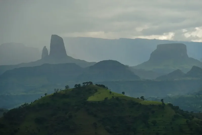
The Simien Mountains National Park is a masterclass in dramatic erosion. Formed by massive volcanic eruptions approximately 40 million years ago, the range was subsequently sculpted by the forces of nature into a labyrinth of canyons and pinnacles. The result is a landscape that defies easy description—a series of "chess pieces of God" rising from the valley floors, surrounded by vast plateaus that sit at an average elevation of 3,300 metres. For the trekker, this means walking along the "edge of the world," where a single step to the left might reveal a 1,500-metre drop into the lowlands below. The scale is humbling, and the silence of the high-altitude air is broken only by the cry of the Lammergeier (bearded vulture) or the rustle of the wind through the heather forests.
Biodiversity is the heartbeat of the Simiens. The park was one of the first sites to be inscribed on the UNESCO World Heritage list in 1978, largely due to its unique and endangered fauna. The Gelada monkeys, often called "Bleeding-heart monkeys" due to the distinctive red patch on their chests, are the most visible residents. Unlike most primates, they are almost entirely graminivorous (grass-eating) and live in massive social groups that can number in the hundreds. Encountering a "super-group" of Geladas as they move across the plateau is a highlight of the trek; they are remarkably habituated to humans, allowing trekkers to sit quietly amongst them as they groom and forage. Higher up, on the precipitous cliffs of Chennek, the Walia ibex—a mountain goat found nowhere else on Earth—can be seen navigating vertical rock faces with terrifying ease. The park is also a sanctuary for the Ethiopian wolf, whose russet coat stands out against the silvery-green of the giant lobelias that dot the Afro-alpine moorlands.
The trekking experience here is distinct from the self-supported style common in Europe or New Zealand. Due to the remote nature of the terrain and park regulations, treks are typically organised with a support team of scouts, guides, and muleteers. This allows walkers to focus on the landscape and the physical demands of the altitude while the logistics of camp-setting and cooking are handled by local experts. The 40-kilometre core route from Sankaber to Chennek provides a concentrated dose of the park’s best features: the Jinbar Waterfall, the 360-degree panoramas of Imet Gogo, and the high-altitude passes where the air is thin and the views are infinite. It is a journey that requires stamina and acclimatisation, but the reward is a perspective on Africa that few ever witness.
History and Cultural Context
The Simien Mountains have been inhabited for over 2,000 years, primarily by the Amhara people, who have developed a resilient and sophisticated agricultural culture suited to the high-altitude environment. The history of the region is inextricably linked to the broader history of the Ethiopian Empire and the Ethiopian Orthodox Tewahedo Church. Throughout the mountains, small villages are perched on ridges and tucked into valleys, where farmers cultivate barley and wheat on steep, terraced slopes. The presence of these communities within and around the national park creates a unique cultural landscape where wilderness and human heritage coexist. Trekkers will frequently encounter local people travelling between villages, often leading mules laden with goods, providing a living connection to the ancient trade routes that once crisscrossed these highlands.
Geologically, the Simiens are part of the Ethiopian Plateau, formed by the outpouring of thick basaltic lavas. This "trap basalt" layering is visible in the cliff faces, where horizontal bands of rock tell the story of successive volcanic events. Over millions of years, the uplift of the African Rift Valley and subsequent erosion by rain and ice carved the deep gorges that define the range today. The mountains were historically a natural fortress, providing a refuge for various groups during times of conflict, including the Beta Israel (Ethiopian Jews), who maintained a significant presence in the region for centuries before their migration to Israel in the late 20th century.
The establishment of the National Park in 1969 was a landmark moment for African conservation, though it has not been without challenges. The balance between protecting endangered species and supporting the livelihoods of local communities has been a central theme in the park's management. In recent years, community-based tourism has become a vital tool for conservation, ensuring that the benefits of trekking reach the people who call these mountains home. Every guide, scout, and muleteer is a resident of the local area, and their knowledge of the land is passed down through generations, adding a layer of oral history and local lore to the trekking experience.
Want more background? Read extended notes on history and cultural context → Learn more
Seasonal Highlights and Weather Reality
The Simien Mountains experience a distinct tropical highland climate, where the primary variation is not between summer and winter, but between the dry and wet seasons. Because the park sits so close to the equator, day length remains relatively constant, but the altitude ensures that temperatures can fluctuate wildly within a 24-hour period.
The Dry Season (October to May): This is the peak trekking window. From October to December, the landscape is still lush and green following the rains, and the air is exceptionally clear, providing the best photographic conditions. As the season progresses into January and February, the grass turns to a shimmering gold, and the weather becomes very stable. During this time, daytime temperatures are pleasant, ranging from 15°C to 20°C, but once the sun sets, the temperature drops precipitously. At campsites like Gich (3,600 m), night-time temperatures frequently fall below freezing, and frost is common on the meadows. Trekkers must be prepared for "four seasons in one day," with intense equatorial sun during the day and biting cold at night.
The Wet Season (June to September): This period is characterised by heavy afternoon rains and frequent mist. While the mountains are at their most vibrant green and the waterfalls are in full flow, trekking becomes significantly more difficult. Trails can become slippery and muddy, and the famous views are often obscured by thick cloud cover. However, for those who don't mind the rain, the "Green Season" offers a sense of solitude and a different kind of beauty, as the alpine flowers come into full bloom. It is worth noting that many tour operators scale back operations during the height of the rains in July and August due to the logistical challenges of moving mules and equipment on saturated trails.
Wind and Sun: Regardless of the season, the sun at 3,500 metres is incredibly strong. Sunburn can occur in minutes, even on cool days. Additionally, the escarpment edges are prone to sudden, strong gusts of wind. Trekkers should always carry a windproof layer and high-factor sun protection, even if the morning starts out calm and overcast.
Recommended Itinerary
5-Day Simien Mountains Highlight Trek
Day 1: Debark to Sankaber
- Distance: 10 km (if walking from the park gate)
- Elevation gain: 400 m
- Time: 4–5 hours
- Morning: Complete permit formalities at the Park Headquarters in Debark.
- Drive to the park entrance or start walking from the outskirts of Debark.
- The trail follows the ridge line, offering the first glimpses of the massive northern escarpment.
- Encounter the first groups of Gelada monkeys grazing near the road and trail.
- Arrive at Sankaber Camp (3,250 m).
- The first day is crucial for acclimatisation; the walking is relatively gentle but the altitude will be felt.
Day 2: Sankaber to Gich
- Distance: 12 km
- Elevation gain: 600 m
- Time: 5–6 hours
- Descend into the valley before a steady climb towards the Jinbar Waterfall.
- View the Jinbar Falls (also known as Geech Abyss), where the water plunges over 500 metres into a deep gorge.
- Cross the Jinbar River and begin the ascent through heather forests draped in "Old Man's Beard" lichen.
- Pass through Gich village, a traditional Amhara settlement.
- Arrive at Gich Camp (3,600 m), located on a wide, exposed plateau.
- Evening: Walk to Kaba or Sagia for sunset views over the lowlands.
Day 3: Gich to Chennek via Imet Gogo
- Distance: 14 km
- Elevation: 400 m gain, 400 m descent
- Time: 7–8 hours
- This is the most spectacular day of the trek, visiting the park's most famous viewpoints.
- Hike to Imet Gogo (3,926 m), a promontory that offers 360-degree views of the entire range.
- Continue along the escarpment to Shayno Sefer and Inatye (4,070 m).
- The trail skirts the very edge of the cliffs, with vertical drops of over 1,000 metres.
- Look for Lammergeiers soaring on the thermals below the cliff edge.
- Descend steeply through giant lobelia forests to Chennek Camp (3,620 m).
- Chennek is the best place to spot the endemic Walia ibex.
Day 4: Chennek to Ambiko (Optional Ras Dashen Approach)
- Distance: 12 km
- Elevation: 600 m gain (to Bwahit Pass), 1,000 m descent
- Time: 6–7 hours
- Climb from Chennek to the Bwahit Pass (4,200 m), the second-highest point in the park.
- From the pass, catch the first view of Ras Dashen, Ethiopia's highest peak, across the Mesheha Valley.
- This area is prime habitat for the Ethiopian wolf.
- Descend steeply into the Mesheha Valley, passing through the village of Chiro Laba.
- Cross the Mesheha River and climb to Ambiko Camp (3,200 m).
- This day involves significant elevation change and is physically demanding.
Day 5: Ambiko to Ras Dashen Summit and Return
- Distance: 16 km (return)
- Elevation: 1,300 m gain and descent
- Time: 10–12 hours
- A pre-dawn start is essential for the summit push.
- The trail climbs steadily through alpine moorland and rocky outcrops.
- The final approach to the summit of Ras Dashen (4,533 m) involves a short, non-technical scramble.
- Stand on the highest point in Ethiopia with views stretching towards the Eritrean border.
- Return to Ambiko for the night or begin the journey back towards the road head.
Important Notes:
- The itinerary can be shortened by ending at Chennek and taking a vehicle back to Debark.
- Acclimatisation is the most important factor for success; do not rush the first two days.
- Mules carry all heavy gear; trekkers only carry a daypack with water, snacks, and layers.
- Campsites are basic; there are no permanent huts, so high-quality tents are required.
- Water must be treated; while mountain streams look clear, they are often used by livestock.
- The mandatory scout must accompany you at all times for safety and park regulation compliance.
Planning and Bookings
Book Your Trip
Everything you need to plan your journey
Accommodation
Find places to stay near Gondar
Flights
Search flights to Gondar
Essential Preparation
Planning a trek in the Simien Mountains requires more logistical coordination than a standard European hike. The primary hub for all trekking activity is the town of Debark, located about 100 kilometres north of Gondar. Most trekkers fly into Gondar Airport (GDQ) and arrange a private transfer or take a public bus to Debark. It is highly recommended to spend at least one or two nights in Gondar (2,133 m) or Debark (2,800 m) before starting the trek to begin the acclimatisation process.
Physical fitness is paramount. While the trails are generally well-defined, the combination of steep gradients and thin air makes every kilometre feel twice as long. Trekkers should be comfortable walking 6–8 hours a day for multiple days. Booking a trek can be done through international agencies, but many walkers prefer to organise everything upon arrival in Debark at the National Park Headquarters. This supports the local economy directly and allows for more flexibility. If you are travelling during the peak season (December–January), pre-booking a guide and transport is advisable.
Trail Accommodation
Accommodation on the Simien Mountains Trek is almost exclusively camping in designated wilderness sites. While the park has seen some development, it remains a rugged experience.
Campsite Facilities:
- Designated flat areas for pitching tents.
- Basic pit latrines (often in poor condition; many trekkers prefer to use "cat holes" following LNT principles).
- A "cook hut" or shelter where your support team will prepare meals.
- Access to a nearby water source (stream or spring).
- No electricity, no showers, and no WiFi.
- Simien Lodge (near Sankaber) and Limalimo Lodge (near Debark) offer luxury eco-accommodation for those who wish to start or end their trek in comfort.
What Campsites Don't Provide:
- Tents, sleeping bags, or mats (these must be brought or hired in Debark).
- Food or cooking fuel.
- Lighting (the camps are pitch black after sunset).
- Trash disposal (you must pack out what you pack in).
Booking Requirements:
- No advance booking is required for the campsites themselves; you pay the camping fees at the Debark HQ when you get your permit.
- Fees are paid per person, per night.
- You must specify your intended route and duration when paying for permits.
Required Gear
- Hiking boots - sturdy, waterproof, and well-worn. The terrain is rocky and can be muddy.
- Sleeping bag - a 4-season bag rated to at least -10°C is essential. Even in the dry season, temperatures at Gich and Chennek can be brutal.
- Insulated jacket - a high-quality down or synthetic "puffy" jacket for evenings in camp.
- Waterproof shell - a breathable Gore-Tex jacket for wind protection and potential rain.
- Trekking poles - highly recommended for the steep descents, especially the drop into the Mesheha Valley.
- Head torch - essential for camp life and the early morning summit push on Ras Dashen.
- Daypack - 25-35L for your daily essentials (water, camera, layers).
- Sun hat and sunglasses - the UV radiation at 4,000 metres is intense.
What to Bring
- Water purification - chlorine tablets, a LifeStraw, or a UV purifier. Do not drink untreated water.
- High-energy snacks - nuts, dried fruit, and energy bars. While your cook will provide meals, you will need fuel during the long climbs.
- Personal medical kit - including Diamox (for altitude), rehydration salts, blister pads, and broad-spectrum antibiotics.
- Toiletries - biodegradable soap, wet wipes (your "mountain shower"), and plenty of toilet paper.
- Power bank - to charge cameras and phones; there is no power on the trail.
- Cash - Ethiopian Birr (ETB) is required for paying tips to your support team and buying sodas or beer in the small villages.
- Lip balm and moisturiser - the air is incredibly dry and will crack your skin quickly.
Permits

All visitors to the Simien Mountains National Park must obtain a permit from the Park Headquarters in Debark. The office is located on the main road and is generally open from 8:30 AM to 5:30 PM. The process is relatively straightforward but involves several different fees that must be paid in cash (Ethiopian Birr).
Mandatory Requirements:
- Park Entrance Fee: A daily fee per person.
- Scout Fee: It is a legal requirement to be accompanied by an armed park scout. This is a tradition dating back to the park's inception. While the scouts carry rifles (usually old Kalashnikovs), their role is primarily to act as a guide, assist with wildlife spotting, and ensure you don't get lost. They are generally very friendly, though many speak limited English.
- Guide Fee: While not strictly mandatory by law in the same way as a scout, the park office strongly insists on a certified local guide for all foreign trekkers. Guides provide essential translation, historical context, and safety management.
- Camping Fees: Paid per person, per night for the duration of your trek.
Logistics and Costs:
- Permits are issued on the spot; there is no need to book weeks in advance.
- You will need to provide your passport details and your intended itinerary.
- Mule and muleteer fees are also regulated by the park office. You will pay for the number of mules required to carry your gear (usually one mule per two trekkers) plus a mule for the cook's equipment.
- Total costs for a 5-day trek (including scout, guide, mules, and permits) typically range from US$300 to US$600 depending on the size of your group and the level of service (e.g., if you hire a professional cook).
Important Tip: Ensure you receive a paper receipt for every fee paid at the HQ. You may be asked to show these at various checkpoints within the park.
Other Activities in the Area
Northern Ethiopia is a treasure trove of history and culture. Consider these additions to your itinerary:
- Gondar Castles: Known as the "Camelot of Africa," the Fasil Ghebbi fortress enclosure in Gondar features 17th-century castles built by Emperor Fasilides and his successors. It is a UNESCO World Heritage site and an essential stop before or after your trek.
- Debre Berhan Selassie Church: Located in Gondar, this church is famous for its ceiling covered in hand-painted winged cherubs and its stunning Ethiopian Orthodox iconography.
- Lalibela: A short flight from Gondar, Lalibela is home to eleven monolithic rock-hewn churches, carved out of solid basalt in the 12th and 13th centuries. It is one of the most important pilgrimage sites in the world.
- Axum: The centre of the ancient Aksumite Empire, featuring massive granite obelisks (stelae) and the Church of Our Lady Mary of Zion, which is said to house the Ark of the Covenant.
- Community Village Visits: Arrange a coffee ceremony in a local village near Debark to experience the legendary Ethiopian hospitality and learn about the traditional way of life in the highlands.
Safety and Conditions
Altitude Sickness (AMS): This is the single greatest risk on the Simien Mountains Trek. Most of the walking takes place above 3,000 metres, and the summit of Ras Dashen exceeds 4,500 metres. Acute Mountain Sickness can affect anyone, regardless of fitness level. Symptoms include headache, nausea, dizziness, and loss of appetite. The key to prevention is "climb high, sleep low," staying hydrated, and ascending slowly. If symptoms persist or worsen, the only cure is immediate descent. Ensure your guide is experienced in identifying AMS and has a clear evacuation plan.
Cold and Exposure: Hypothermia is a genuine risk, especially if you get wet or if the wind picks up on the high passes. The temperature drop at night is extreme. Always carry a dry set of thermal layers specifically for sleeping, and never underestimate the power of the wind on the escarpment.
Wildlife: While the Gelada monkeys are peaceful, they are wild animals and should not be approached too closely or fed. The Ethiopian wolf is shy and poses no threat to humans. The Walia ibex are found on steep cliffs; do not attempt to follow them off-trail. The most common "dangerous" animals are domestic dogs in the villages, which can be territorial.
Remote Terrain: There is no mobile signal in most of the park, and medical facilities in Debark are very basic. For any serious injury or illness, evacuation to Gondar or Addis Ababa would be necessary. It is essential to have comprehensive travel insurance that covers high-altitude trekking and emergency helicopter evacuation.
Water Safety: Giardia and other water-borne parasites are common in the region. Never drink untreated water from streams, even if they look pristine. Use a high-quality filter or purification tablets for all water, including water used for brushing teeth.
Side Trips and Points of Interest
Imet Gogo: Often cited as the most beautiful spot in the entire park, Imet Gogo is a narrow ridge that juts out from the main plateau. From the tip, you can see the "lowlands" 1,500 metres below, the jagged peaks of the "chess pieces," and the distant silhouette of the Eritrean mountains. It is the ultimate spot for photography and a perfect place to sit and contemplate the sheer scale of the African continent.
Jinbar Waterfall: One of the highest waterfalls in Africa, the Jinbar Falls is a spectacular sight, especially in the early dry season (October–November). The water drops vertically into a narrow, dark abyss. The viewpoint on the opposite side of the gorge allows you to see the full height of the falls and the vultures nesting in the cliffs nearby.
Bwahit Peak: At 4,430 metres, Bwahit is the second-highest peak in the park and is much more accessible than Ras Dashen. It offers a fantastic alternative for those who don't have the time or energy for the full Ras Dashen climb. The views from the summit back towards the Gich plateau and Imet Gogo are sensational.
The Giant Lobelia Forests: These prehistoric-looking plants (Lobelia rhynchopetalum) can grow up to 10 metres tall when in flower. They are a signature feature of the Afro-alpine zone and create an otherworldly atmosphere, especially when the mist rolls in across the moorlands. They are also the primary habitat for the Ethiopian wolf.
Leave No Trace
The Simien Mountains National Park is a fragile ecosystem under significant pressure from grazing and human activity. As a trekker, your impact should be minimal to ensure the survival of the endemic species and the beauty of the landscape.
Your responsibility as a walker:
- Pack it in, pack it out: There is no waste management system in the park. All trash, including fruit peels and cigarette butts, must be carried back to Debark.
- Respect the wildlife: Never feed the Gelada monkeys or any other animals. Feeding disrupts their natural foraging behaviour and can make them aggressive.
- Stay on the trail: The alpine vegetation is slow-growing and easily damaged. Avoid creating new paths, especially on steep slopes where erosion is a major concern.
- Water protection: Do not use soap or detergents in the streams. If you need to wash, carry water 30 metres away from the source and use biodegradable soap.
- Human waste: Use the provided pit latrines at campsites whenever possible. If you are caught short on the trail, bury waste in a hole 15-20 cm deep, at least 50 metres from water and trails. Pack out your toilet paper in a sealed bag.
- No fires: Wood is a scarce resource in the highlands and is needed by local communities for cooking. Use gas or multi-fuel stoves for all cooking.