Ethiopia — Gondar
Ethiopia's Simien Mountains Trek: a 40km, 4-7 day odyssey across the "Roof of Africa." This challenging route traverses a UNESCO World Heritage landscape of jagged volcanic plugs and precipitous escarpments, offering breathtaking panoramas and a glimpse of ancient wilderness. Expect rugged terrain and high-altitude walking on this demanding Ethiopian highland adventure.
Distance: 40.0 km
Elevation Gain: 3000 m
Difficulty: Challenging
Duration: 4-7 days
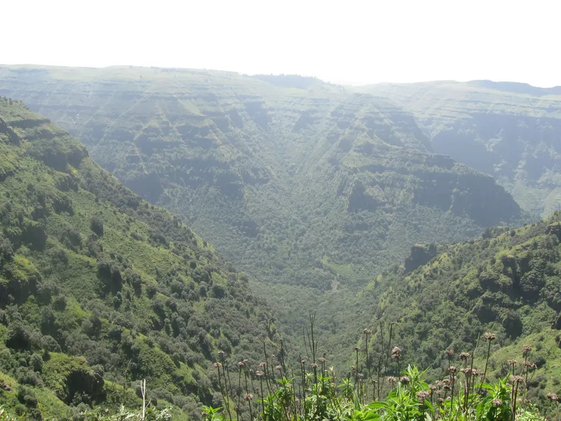
The Simien Mountains Trek is Ethiopia’s most magnificent high-altitude odyssey—a journey through a landscape so jagged and prehistoric that it was among the first sites ever inscribed on the UNESCO World Heritage list in 1978. Located in the Amhara Region of northern Ethiopia, this trek traverses the "Roof of Africa," a massive plateau of volcanic plugs and deep precipices that rise from the surrounding lowlands like the battlements of a celestial fortress. The route typically spans 40 kilometres of the most dramatic terrain on the continent, reaching elevations that exceed 4,000 metres. This is not merely a walk; it is an immersion into an Afro-alpine ecosystem where the air is thin, the vistas are infinite, and the wildlife is found nowhere else on Earth. From the sheer 1,500-metre drops of the northern escarpment to the golden grasslands of the high plateaus, the Simien Mountains offer a trekking experience that combines raw geological power with profound cultural depth.
The Simien Mountains National Park is a geological masterpiece, often described as the "Chess Pieces of God" due to the bizarre shapes of its volcanic spires and deep, eroded canyons. The trek is defined by its extraordinary verticality. Unlike many mountain ranges that rise gradually, the Simiens are characterised by a massive central plateau that terminates abruptly in a series of staggering cliffs. For much of the trek, walkers follow the rim of this northern escarpment, where the ground simply vanishes into a vertical abyss, revealing the lowland plains of the Tekeze River basin over a kilometre below. This creates a visual drama that is arguably unmatched by any other mountain range in Africa, including the Atlas or the Drakensberg.
The biological significance of the Simiens is as compelling as its geology. The range serves as a final refuge for several of Ethiopia’s endemic flagship species. Walkers are almost guaranteed to encounter the Gelada—often called the "Bleeding-heart Monkey"—which live in massive social groups of up to several hundred individuals. These unique primates are grass-eaters and remarkably indifferent to human presence, allowing trekkers to sit amongst them as they forage. Higher up, the elusive Walia ibex, a mountain goat found only in this park, clings to the precipitous cliffs, while the Ethiopian wolf—the world’s rarest canid—hunts for rodents in the Afro-alpine moorlands. The flora is equally distinct, dominated by the Giant Lobelia, which grows like a prehistoric sentinel across the high-altitude plains, and ancient Erica (heather) forests draped in silvery lichens.
Physically, the trek is a test of endurance and acclimatisation. While the paths are generally well-trodden by local communities and pack animals, the sustained elevation above 3,000 metres places significant demand on the cardiovascular system. The weather is a study in extremes: intense equatorial sun during the day can quickly give way to sub-zero temperatures at night. However, the reward for this physical exertion is a sense of profound isolation and a connection to a landscape that feels as though it has remained unchanged for millennia. Whether standing on the summit of Imet Gogo or watching the sunset over the Gich plateau, the Simien Mountains Trek provides a perspective on the natural world that is both humbling and exhilarating.
The Simien Mountains have been inhabited for over 2,000 years, serving as a rugged sanctuary for the Amhara people and, historically, the Beta Israel (Ethiopian Jewish) communities. The name "Simien" translates to "North" in Amharic, reflecting the range's position relative to the ancient capital of Axum. The mountains were formed approximately 40 million years ago by massive volcanic eruptions that deposited layers of basaltic lava up to 3,000 metres thick. Over subsequent eons, extreme erosion by water and ice carved the deep valleys and jagged plugs that define the landscape today. This geological history is intertwined with human history; the mountains have long been a site of agricultural ingenuity, with terraced fields clinging to impossibly steep slopes where farmers grow barley and wheat at altitudes that would baffle most European agriculturists.
In the 1960s, international recognition of the Simiens' unique biodiversity led to the establishment of the National Park in 1969. It was one of the first twelve sites globally to be recognised by UNESCO in 1978. However, the park's history has not been without conflict. For decades, the pressure of human settlement and overgrazing by livestock threatened the habitat of the Walia ibex and the Ethiopian wolf. This led to the park being placed on the "List of World Heritage in Danger" in 1996. Through intensive conservation efforts, community relocation programmes, and the expansion of park boundaries, the Simiens were successfully removed from the danger list in 2017. Today, the park operates under a unique management system where local communities are integrated into the tourism economy as guides, scouts, and muleteers, ensuring that the protection of the mountains provides a direct benefit to those who live there.
Walking through the Simiens is as much a cultural experience as a wilderness one. You will share the trails with local villagers travelling between remote hamlets, their mules laden with supplies. You will see children herding sheep on the high plateaus and pass through villages where the traditional "tukul" (circular stone hut) remains the primary form of architecture. This human presence adds a layer of living history to the trek, reminding walkers that these mountains are not just a park, but a home.
Want more background? Read extended notes on history and cultural context → Learn more
The trekking season in the Simien Mountains is dictated by the Ethiopian monsoon cycle. The primary window for trekking is the dry season, which runs from October to May. During this period, the skies are generally clear, providing the expansive views for which the park is famous. However, each month within this window offers a slightly different experience.
October to November: This is often considered the most beautiful time to visit. The "Big Rains" have just ended, leaving the landscape incredibly lush and green. Wildflowers, including the yellow Meskel daisies, carpet the plateaus. The air is crisp and the dust is minimal, though there is still a slight chance of afternoon showers. This is the "Green Season" at its peak.
December to February: This is the height of the dry season and the most popular time for trekking. Visibility is at its maximum, making it the best time for photography. However, the landscape begins to turn a golden-brown as the grasses dry out. Temperatures during the day are pleasant (15–20°C), but nighttime temperatures on the high plateaus (especially at Gich and Chennek) frequently drop below freezing, sometimes reaching -5°C or -10°C. Frost is common in the mornings.
March to May: The weather remains dry, but the temperature begins to rise. This is the warmest time of year in Ethiopia. Haze can sometimes reduce long-distance visibility as dust from the lowlands rises into the mountains. However, this is an excellent time for wildlife viewing as animals congregate near permanent water sources.
June to September: This is the rainy season (Kiremt). Trekking during this time is extremely challenging and generally not recommended for most walkers. Heavy rains can turn trails into mud slides, and thick clouds often shroud the escarpment for days, completely obscuring the views. Thunderstorms are frequent and can be dangerous at high altitudes. However, for those who do brave the rains, the waterfalls (such as Jinbar) are at their most thunderous and spectacular.
Day 1: Debark to Sankaber
Day 2: Sankaber to Gich
Day 3: Gich to Chennek via Imet Gogo
Day 4: Chennek to Bwahit Peak and return
Day 5: Chennek to Gondar
Important Notes:
Trekking in the Simien Mountains requires more logistical coordination than a standard European or North American hike. The primary hub for all planning is the town of Debark, located 100 kilometres north of Gondar. You cannot simply turn up and start walking; the park has strict regulations regarding mandatory staff. Every group, regardless of size, must hire a park-certified scout (armed, as per traditional regulations, though primarily for symbolic protection and wildlife management). While not strictly mandatory, hiring a professional guide is highly recommended for navigation, wildlife spotting, and cultural translation.
Fitness is a critical component of preparation. While the technical difficulty of the trails is moderate, the altitude is significant. You will be walking for 5–8 hours a day at elevations where oxygen levels are roughly 60–70% of those at sea level. It is strongly advised to spend at least two nights in Gondar (2,133 m) or Debark (2,850 m) before starting the trek to begin the acclimatisation process. Cardiovascular training (hiking, running, or cycling) in the months leading up to the trip will significantly improve your enjoyment of the experience.
Accommodation within the Simien Mountains National Park is primarily based on wilderness camping. There are three main designated campsites used on the standard route: Sankaber, Gich, and Chennek. These are basic facilities designed to minimise human impact on the environment.
Campsite Facilities:
Simien Lodge: Located near the park entrance at Buyit Ras, this is the highest lodge in Africa. It offers luxury "tukul" style rooms with underfloor heating and en-suite bathrooms. Many trekkers choose to stay here on their first or last night for a touch of comfort, but it is not located on the main multi-day trekking circuit between Gich and Chennek.
Booking Requirements: There is no centralised online booking system for campsites. Fees are paid in cash (Ethiopian Birr) at the Park Headquarters in Debark upon arrival. You must specify the number of nights you intend to spend in the park. If you are booking through a tour operator, these fees and the provision of tents/sleeping mats are usually included in your package.
The permit system for the Simien Mountains is managed by the Ethiopian Wildlife Conservation Authority (EWCA) through the park office in Debark. The process is manual and requires a physical visit to the headquarters before you enter the park. It is an organised but sometimes time-consuming process, so allow at least two hours on your first morning.
The Permit Process:
Estimated Costs (Subject to change, check locally):
Important Logistics: All payments at the park office must be made in Ethiopian Birr. There are ATMs in Debark, but they are frequently out of cash or out of service; it is highly recommended to withdraw all the cash you need in Gondar or Addis Ababa before travelling to Debark. Keep your permit receipts in a waterproof bag, as they may be checked by rangers at various points within the park.

Detailed route notes, maps, logistics & tips for the Simien Mountains (PDF).

Precisely traced GPX for the Simien Mountains, ready for your GPS or favourite mapping app.
The Simien Mountains are located in the heart of Ethiopia's "Historic Circuit," making it easy to combine a trek with world-class cultural sites:
Altitude Sickness (AMS): This is the primary safety concern in the Simiens. Most of the trek takes place above 3,000 metres, and Bwahit Peak reaches 4,430 metres. Acute Mountain Sickness can affect anyone, regardless of age or fitness level. Symptoms include headache, nausea, dizziness, and loss of appetite. The best prevention is a slow ascent and proper hydration (3–4 litres of water per day). If symptoms become severe (persistent vomiting, confusion, or shortness of breath at rest), the only cure is immediate descent. Ensure your guide is experienced in recognising AMS symptoms.
Wildlife Safety: While the Gelada monkeys are generally peaceful and indifferent to humans, they are wild animals with formidable canine teeth. Do not attempt to feed them, touch them, or get between a mother and her infant. The Ethiopian wolf is extremely shy and poses no threat to humans. The mandatory scout is present partly to ensure safe distances are kept from wildlife and to prevent any potential (though rare) conflict with local livestock herders.
Weather Extremes: Hypothermia is a genuine risk, even in Africa. The combination of high altitude, wind chill on the escarpment, and a sudden drop in temperature after sunset can be dangerous if you are not wearing appropriate layers. Always carry a waterproof shell and a warm layer in your daypack, even if the morning starts clear and hot.
Remote Location: There is no formal mountain rescue service in the Simien Mountains. In the event of a serious injury or illness, evacuation is usually by 4x4 vehicle (if near a road-accessible camp like Chennek or Sankaber) or by mule. Helicopter evacuation is extremely difficult to arrange and requires pre-authorisation from the military. Comprehensive travel insurance that covers high-altitude trekking and emergency evacuation is essential.
Sun Exposure: At 4,000 metres, the atmosphere is thinner and provides less protection from UV radiation. Severe sunburn and sunstroke can occur quickly. Wear a hat, use high-factor sunscreen, and protect your eyes with category 3 or 4 sunglasses.
Imet Gogo (3,926 m): Often cited as the most spectacular viewpoint in all of Africa. This narrow ridge of rock juts out from the main escarpment, providing a 360-degree view of the surrounding peaks, the lowlands, and the sheer cliffs. It is the highlight of Day 3 and the perfect spot for a long lunch break. The rock formations here are particularly jagged and photogenic.
Jinbar Waterfall: One of the highest waterfalls in Africa, though its volume varies significantly by season. The water plunges roughly 500 metres into a narrow, forested canyon. The viewpoint on the opposite cliff allows you to see the full drop and the vultures circling in the thermals of the abyss. It is a short detour from the main trail between Sankaber and Gich.
Ras Dashen (4,550 m): For those with more time (usually a 7-day itinerary), the trek can be extended to the summit of Ras Dashen, the highest mountain in Ethiopia. This requires descending from the Chennek plateau into the Mesheha Valley and then a long, arduous climb to the summit. While not technically difficult (it is a "walk-up"), the altitude makes it a significant physical challenge. The view from the top encompasses the entire Simien range.
The Gich Abyss: Near Gich Camp, there are several points where you can sit on the edge of the world. The "Kaba" view offers a perspective on the verticality of the range that is dizzying. It is a popular spot for evening walks to watch the sunset, as the light hits the western-facing cliffs of the escarpment.
Erica Forests: Between Sankaber and Gich, the trail passes through ancient groves of Giant Heath (Erica arborea). These trees, which in Europe are small shrubs, grow to 10 metres tall here. They are covered in epiphytic mosses and lichens, creating a "cloud forest" atmosphere that feels completely different from the open moorlands higher up.
The Simien Mountains National Park is a fragile ecosystem under significant pressure from human activity. As a visitor, it is your responsibility to minimise your impact to ensure the park remains a viable habitat for its endemic species.
Guidelines for Responsible Trekking:
By following these principles, you help preserve the "Roof of Africa" for the Walia ibex, the Gelada, and the generations of trekkers who will follow in your footsteps.