
Sierra Nevada Trail - A Patagonian Gem
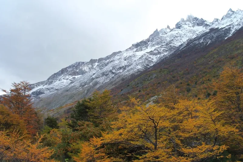
The Sierra Nevada Trail is a challenging and rewarding multi-day trek located in the heart of Chile's Andes Mountains, offering a spectacular immersion into the rugged beauty of Patagonia. This trail winds through dramatic glacial valleys, past turquoise lakes, and over high mountain passes, providing breathtaking vistas of snow-capped peaks, ancient forests, and pristine alpine environments. It is a journey that tests physical endurance while offering profound connection with raw, untamed nature. The trail is renowned for its challenging terrain, requiring good fitness and preparedness, but the unparalleled scenery and sense of accomplishment make it a highly sought-after adventure for experienced hikers.
- Distance: 45.0 km one-way
- Duration: 3-4 days
- Season: November to March (Summer in Chile)
- Huts: Basic refugios and designated camping areas
- Highest point: Approximately 2,800 m
- Daily walkers: Variable, no strict limits but low visitor numbers
- Direction: Typically walked from north to south, but can be done in reverse
Overview
The Sierra Nevada Trail is a testament to the wild, untamed spirit of the Chilean Andes. Unlike more manicured routes, this track demands respect for its formidable landscape. The journey typically begins near San Jose de Maipo, a gateway town to the high Andes, and progresses through a series of increasingly dramatic valleys. Early sections might involve traversing scree slopes and rocky paths, gradually ascending towards the treeline. As you gain altitude, the vegetation thins, giving way to hardy alpine flora and vast expanses of rock and ice. The trail is characterised by significant elevation changes, with steep ascents and descents that challenge even seasoned hikers. The reward for this effort is access to some of the most spectacular, remote mountain scenery in the region.
Water is a constant companion, with glacial meltwater feeding vibrant blue lakes and rushing streams. The air is crisp and clean, carrying the scent of pine and damp earth. Wildlife, though often elusive, can include condors soaring on thermals, guanacos grazing on high plateaus, and various smaller alpine creatures. The silence of the mountains is profound, broken only by the wind, the cry of a bird, or the distant rumble of a rockfall. This is a place where the sheer scale of nature humbles the individual, offering a true escape from the modern world.
The trail's remoteness means that self-sufficiency is paramount. Hikers must carry all necessary food, water treatment, and safety equipment. While there are basic refugios and camping spots, these are rudimentary and require advance planning. The best time to undertake this trek is during the Chilean summer (November to March), when weather conditions are generally more stable, though still unpredictable in the high mountains. Even in summer, snow can persist at higher elevations, and sudden storms are always a possibility.
History and Cultural Context
The region surrounding the Sierra Nevada Trail has a long history of human interaction, primarily driven by resource extraction and exploration. For centuries, indigenous peoples, including the Picunche and later the Inca, traversed these mountain ranges, utilising them for hunting and as routes for trade. The discovery of mineral wealth, particularly copper and gold, in the 18th and 19th centuries led to increased exploration and the establishment of mining camps and routes throughout the Andes. Many of the trails used today have their origins in these historical pathways, carved out by miners, prospectors, and early explorers seeking to exploit the mountain's riches.
The development of the modern trail system in this area is relatively recent, driven by the growing popularity of adventure tourism and mountaineering in Chile. The Sierra Nevada itself, a prominent massif, has long been a target for climbers and trekkers drawn to its challenging peaks and remote valleys. The establishment of national parks and protected areas, such as the Monumento Natural El Morado and nearby reserves, has helped to preserve these landscapes and formalise some of the hiking routes. However, much of the Sierra Nevada Trail remains in a wild, undeveloped state, reflecting its history as a frontier of exploration rather than a curated tourist attraction.
The cultural landscape is also shaped by the presence of traditional Andean communities who have maintained their way of life in the foothills for generations. Their knowledge of the land, its resources, and its weather patterns is invaluable. While the trail itself is primarily a natural wonder, understanding the historical context of human presence in the Andes adds another layer of appreciation to the journey.
Seasonal Highlights and Weather Reality
The Sierra Nevada Trail is a high-altitude trek, and its accessibility and conditions are heavily dictated by the seasons. The primary hiking season runs from November to March, coinciding with the Southern Hemisphere's summer. During these months, the snowpack at lower and mid-elevations typically recedes, making the trails more passable. Days are longer, offering more daylight hours for hiking, and temperatures are generally milder, though still cool at higher altitudes.
Summer (December to February): This is the peak season for trekking. The weather is generally more stable, with clearer skies and warmer temperatures. However, this is also the time when afternoon thunderstorms are common. These storms can develop rapidly, bringing heavy rain, strong winds, lightning, and even hail. Temperatures can still drop significantly at night and on exposed passes. Sandflies can be present, though generally less of an issue than in coastal Fiordland. The landscape is vibrant, with alpine meadows potentially in bloom.
Shoulder Seasons (November and March): These months offer a good balance between fewer crowds and generally favourable weather. However, there is a higher chance of encountering lingering snow at higher elevations in November, and early snowfalls can occur in March. Weather can be more unpredictable, with a greater possibility of rain and colder temperatures. These periods can be ideal for those seeking solitude and willing to be more flexible with their plans.
Winter (April to October): The trail is largely impassable and dangerous during the winter months due to heavy snowfall, ice, and extreme cold. Avalanche risk is high. Only experienced mountaineers with appropriate winter gear and expertise should consider attempting any part of the route during this period. Huts and refugios may be closed or offer very basic shelter.
Weather Considerations: Regardless of the season, the Andes are known for their volatile weather. Hikers must be prepared for rapid changes, including sudden drops in temperature, strong winds, and precipitation. Always check the mountain forecast before setting out and be prepared to alter your plans if conditions deteriorate.
Recommended Itinerary

3-Day Sierra Nevada Trail Itinerary
Day 1: San Jose de Maipo to Refugio Lo Valdes
- Distance: Approximately 15 km
- Elevation gain: Approximately 1,000 m
- Time: 6–8 hours
- Start from San Jose de Maipo, arrange transport to the trailhead (e.g., near El Manzano or further up the road towards Lo Valdes)
- Initial section may involve walking along a gravel road or track
- Ascend through scrubland and sparse forest
- Pass through areas with potential for small streams and waterfalls
- Arrive at Refugio Lo Valdes, a basic mountain shelter
- Set up camp near the refugio if camping is preferred
- This day focuses on gaining significant altitude and acclimatising to the mountain environment
Day 2: Refugio Lo Valdes to Laguna del Inca (or nearby high camp)
- Distance: Approximately 12 km
- Elevation gain: Approximately 800 m
- Time: 5–7 hours
- Continue ascent from Refugio Lo Valdes
- Traverse rocky terrain, scree slopes, and potentially snowfields depending on the season
- Pass through alpine meadows and potentially cross small glacial streams
- Reach high mountain passes offering panoramic views of the surrounding peaks and valleys
- Aim for Laguna del Inca or a suitable high-altitude camping spot with water access
- This is the most challenging day, involving significant elevation gain and potentially difficult terrain
- The views from the high points are the primary reward
Day 3: Laguna del Inca to Trailhead (and return to San Jose de Maipo)
- Distance: Approximately 18 km
- Elevation loss: Approximately 1,800 m
- Time: 6–8 hours
- Begin the descent from the high camp
- Follow a different route or retrace steps, depending on the chosen descent path
- The descent can be steep and demanding on the knees
- Pass through varied terrain, from rocky slopes to more vegetated areas as you lose altitude
- Rejoin the access road or trail leading back to the trailhead
- Arrange for pick-up at the trailhead or walk back to a point where transport is available
- Return to San Jose de Maipo
- This day focuses on a long descent, requiring careful footing and stamina
Alternative 4-Day Itinerary:
- Day 1: San Jose de Maipo to a lower camp/refugio.
- Day 2: Camp 1 to a high camp near Laguna del Inca.
- Day 3: Explore around Laguna del Inca, potentially a shorter day hike to a nearby peak or viewpoint.
- Day 4: Descend from high camp back to the trailhead.
Important Notes:
- This itinerary is a guideline; actual distances and times can vary significantly based on route choice, weather, and individual pace.
- Accommodation is basic: Refugios are simple shelters, and camping is often the primary option. Bookings for refugios may be required and should be confirmed in advance.
- Water sources are generally available from streams and lakes, but purification is essential.
- The trail is not always well-marked; navigation skills and a GPS device are highly recommended.
- Be prepared for rapid weather changes, especially at higher elevations.
Planning and Bookings
Book Your Trip
Everything you need to plan your journey
Accommodation
Find places to stay near Santiago
Flights
Search flights to Santiago
Essential Preparation
The Sierra Nevada Trail is a serious undertaking that requires meticulous planning. Given its remote nature and challenging terrain, thorough preparation is non-negotiable. Begin by assessing your fitness level; this trek demands excellent cardiovascular endurance, strength, and resilience to cope with long days of hiking over uneven ground and significant elevation changes. Familiarise yourself with the route using detailed maps and GPS data, as trail marking can be inconsistent. Inform someone of your itinerary and expected return date. Base town logistics are crucial: San Jose de Maipo is the primary hub for accessing the trail. Here, you can arrange transport to the trailhead, purchase last-minute supplies, and find accommodation. It's advisable to spend at least one night in San Jose de Maipo before and after your trek to acclimatise and recover.
Trail Accommodation
Accommodation on the Sierra Nevada Trail is rudimentary and requires advance booking or self-sufficiency. The primary options are basic mountain refugios and designated camping areas.
Refugios: These are typically simple stone or wooden shelters offering basic protection from the elements. They often provide a communal sleeping area with bunks (bring your own sleeping bag) and sometimes a basic cooking area. Facilities are minimal, with no electricity or running water. Some refugios may require advance booking, especially during peak season. It is essential to confirm availability and booking procedures well in advance.
Camping: Designated camping areas are often found near refugios or at strategic points along the trail. Wild camping may be permitted in some areas, but it is crucial to adhere to local regulations and practice Leave No Trace principles. Campsites are usually undeveloped, meaning you will need to be entirely self-sufficient for water, cooking, and waste disposal.
What's Provided: Basic shelter (refugios), potentially a flat area for tents (campsites). Some refugios might have a rudimentary stove or fireplace.
What's NOT Provided: Sleeping bags, mattresses, cooking equipment, food, water, electricity, heating, toilet facilities (beyond basic pit latrines at some refugios), or any form of luxury. You must bring everything you need.
Seasonal Availability: Refugios and camping are generally accessible from November to March. Outside this period, they may be closed or inaccessible due to snow and harsh weather conditions.
Costs: Refugio fees are typically modest, often ranging from US$10-30 per night. Camping fees, if applicable, are similar. These costs should be confirmed with local operators or park authorities.
Note: This is a challenging trek, and the accommodation reflects its wild nature. Do not expect comfortable amenities.
Required Gear
- Sturdy hiking boots: Waterproof, well broken-in, with good ankle support. Essential for navigating rocky and uneven terrain.
- Waterproof and windproof jacket and trousers: High-quality, breathable materials (e.g., Gore-Tex) are crucial for protection against unpredictable mountain weather.
- Warm layers: Multiple synthetic or wool layers (base, mid, and outer) to adapt to changing temperatures. Avoid cotton.
- Sleeping bag: Rated for sub-zero temperatures (e.g., -5°C to -10°C comfort rating), as nights can be very cold, even in summer.
- Backpack: 50-70 litre capacity, with a comfortable harness and rain cover.
- Navigation tools: Topographic maps of the area, a reliable compass, and a GPS device or smartphone with offline maps and a fully charged power bank. Trail marking can be sparse.
- Head torch: With spare batteries. Essential for early starts, late finishes, and navigating in refugios.
- First-aid kit: Comprehensive kit including blister treatment, pain relievers, antiseptic wipes, bandages, and any personal medications.
- Sun protection: High SPF sunscreen, sunglasses, and a wide-brimmed hat. The sun at altitude is intense.
- Trekking poles: Highly recommended for stability on ascents and descents, and to reduce strain on knees.
What to Bring
- Food: Lightweight, high-energy food for the duration of your trek (breakfasts, lunches, dinners, snacks). Plan for at least one extra day's supply in case of delays.
- Water treatment: Water filter, purification tablets, or UV steriliser. While water sources are generally available, they must be treated.
- Cooking equipment: Lightweight camping stove, fuel, pot, mug, bowl, and utensils.
- Toiletries: Biodegradable soap, toothbrush, toothpaste, toilet paper, hand sanitiser, and a small trowel for burying human waste if necessary (follow LNT principles).
- Personal items: Camera, journal, book, insect repellent (especially for lower elevations), and any personal comfort items.
- Emergency shelter: Lightweight emergency bivvy bag or space blanket.
- Repair kit: Duct tape, cordage, needle and thread for gear repairs.
- Cash: For potential refugio fees, transport, or emergency purchases in San Jose de Maipo.
Permits
Currently, there are no specific permits required for hiking the Sierra Nevada Trail itself, as it traverses areas that are not strictly regulated national parks with mandatory booking systems like some other famous treks. However, this situation can change, and it is always advisable to check with local authorities or park rangers in San Jose de Maipo for the most up-to-date information regarding access and any potential regulations, especially if you plan to enter protected areas adjacent to the main trail.
Access and Transport:
- San Jose de Maipo: This town is the primary gateway. You will need to arrange transport from Santiago to San Jose de Maipo (approximately 2 hours by bus).
- Trailhead Access: From San Jose de Maipo, you will need to arrange a taxi or local transport to reach the specific trailhead. The road to the higher elevations can be unpaved and may require a 4x4 vehicle, especially closer to the mountains. Confirm road conditions and transport options in advance.
- Parking: If you drive your own vehicle, parking at the trailhead is usually limited and may not be secure. It is generally recommended to use local transport services.
Refugio Bookings: While formal permits may not be required for the trail, it is highly recommended to contact the operators of any refugios you plan to use well in advance to confirm availability and make reservations. Refugios can be basic and have limited capacity, and booking ahead ensures you have a place to stay.
National Park Regulations: If your route takes you through or adjacent to national parks or protected areas (e.g., Monumento Natural El Morado), be aware of their specific regulations regarding camping, fires, and waste disposal. These areas may have their own fee structures or access rules.
Always verify: Before your trip, consult with the local tourism office in San Jose de Maipo or the relevant Chilean national park authority for the latest information on trail conditions, access, and any required permits or fees.
Other Activities in the Area
The region surrounding the Sierra Nevada Trail offers a wealth of activities for those looking to extend their stay or explore beyond the trek:
- Climbing and Mountaineering: The Andes are a paradise for climbers. Peaks like Cerro El Morado offer challenging ascents for experienced mountaineers. Guided climbs can be arranged from San Jose de Maipo.
- Hot Springs: Several natural hot springs are located in the Cajón del Maipo, offering a relaxing way to soothe tired muscles after a long hike. Termas de Colina is a popular, rustic option.
- Horseback Riding: Explore the lower valleys and foothills on horseback. Local operators offer guided rides suitable for various skill levels.
- Rafting and Kayaking: The Maipo River provides opportunities for white-water rafting and kayaking, particularly during the spring and summer meltwater season.
- Exploring San Jose de Maipo: The town itself is charming, with local markets, artisan shops, and traditional Chilean restaurants. It's a good place to experience local culture and cuisine.
- Day Hikes: Numerous shorter day hikes are accessible from San Jose de Maipo, offering a taste of the Andean landscape without the commitment of a multi-day trek. Examples include routes around Embalse el Yeso or to waterfalls in nearby valleys.
- Scenic Drives: The road through the Cajón del Maipo offers spectacular views of the mountains, rivers, and valleys. Driving to Embalse el Yeso provides access to a stunning turquoise reservoir.
Safety and Conditions
Pre-Trip Checks:
- Weather Forecast: Always check the mountain weather forecast for the specific region of the Sierra Nevada before and during your trek. Websites like MeteoChile or local mountaineering resources are invaluable. Be prepared for rapid changes, including strong winds, rain, snow, and significant temperature drops, even in summer.
- Trail Conditions: Inquire locally in San Jose de Maipo about current trail conditions. Snow can linger on high passes well into summer, and recent rainfall can make river crossings hazardous.
- Road Conditions: If travelling by private vehicle, check the status of the roads leading to the trailhead, as they can be rough and may require a 4x4.
- Inform Someone: Leave a detailed itinerary with a trusted contact, including your expected return date and time.
Altitude Sickness: The Sierra Nevada Trail reaches significant altitudes (up to 2,800 m or higher). Acclimatise properly by spending at least one night in San Jose de Maipo (around 1,000 m) before starting your trek. Ascend gradually, stay hydrated, and avoid alcohol and strenuous activity on your first day at altitude. Symptoms include headache, nausea, dizziness, and fatigue. If symptoms worsen, descend immediately.
River Crossings: Glacial meltwater can create fast-flowing and deep rivers, especially during warmer parts of the day. Assess each crossing carefully. If a river appears too dangerous, do not attempt to cross. Wait for conditions to improve or find an alternative route. Use trekking poles for stability.
Navigation: Trails can be poorly marked or disappear entirely in certain sections, especially above the treeline. Carry a map, compass, and GPS device, and know how to use them. Offline map apps on a smartphone are useful but should be backed up with traditional navigation tools.
Wildlife: While large predators are rare, be aware of potential encounters with guanacos, foxes, and various bird species. Do not feed wildlife. Condors are majestic but should be observed from a distance.
Emergency: Mobile phone reception is unreliable to non-existent in most of the trekking area. Consider carrying a Personal Locator Beacon (PLB) or satellite messenger for emergencies. Know the location of the nearest emergency services and how to contact them (this will likely involve descending to a point with reception or sending someone for help).
Travel Insurance: Ensure your travel insurance covers high-altitude trekking and potential emergency evacuation.
Side Trips and Points of Interest
Laguna del Inca: A stunning high-altitude lake that is a focal point of the trek. Its turquoise waters, often surrounded by snow-capped peaks, offer spectacular photographic opportunities. Depending on the route, you might camp near its shores, providing an unforgettable alpine experience.
Cerro El Morado: While not part of the main trail, this prominent peak is a significant landmark in the region. For experienced mountaineers, it offers a challenging ascent with rewarding panoramic views. Even from the trail, its imposing presence is a constant reminder of the rugged Andean landscape.
Embalse el Yeso: A large, artificial reservoir with incredibly vibrant turquoise water, located a drive away from the main trekking area but accessible from San Jose de Maipo. It's a popular spot for day trips and offers dramatic scenery, though it is not directly on the Sierra Nevada Trail route.
Valle de las Arenas: This valley, often part of the approach or descent, is characterised by its vast scree slopes and rocky terrain. While challenging underfoot, it offers a raw, elemental mountain experience and unique geological formations.
Glacial Features: Keep an eye out for evidence of past glaciation, including U-shaped valleys, moraines, and cirques. The landscape is a living testament to the powerful forces of ice that shaped the Andes.
Alpine Flora and Fauna: Even in the harsh alpine environment, life persists. Look for hardy wildflowers in meadows during summer, and keep an eye out for condors soaring overhead, guanacos grazing on distant slopes, and smaller alpine birds.
Leave No Trace
The Sierra Nevada Trail traverses a fragile alpine environment that is susceptible to human impact. Adhering to Leave No Trace principles is paramount to preserving its natural beauty and ecological integrity for future generations. As a visitor, you are an ambassador for responsible outdoor recreation.
Plan Ahead and Prepare: Research the trail, understand its challenges, and pack appropriately. This minimises the need for improvisation and reduces the risk of environmental damage.
Travel and Camp on Durable Surfaces: Stick to established trails and camp in designated areas or on durable surfaces like rock, gravel, or dry grass. Avoid trampling vegetation, especially in meadows where plants are delicate and slow to recover.
Dispose of Waste Properly: Pack out everything you pack in, including all food scraps, wrappers, and toilet paper. Use designated toilets where available. If no facilities exist, dig catholes at least 60 metres away from water sources, trails, and campsites, and bury human waste and toilet paper. Pack out all toilet paper.
Leave What You Find: Resist the urge to take natural souvenirs like rocks, plants, or artefacts. Leave the environment as you found it.
Minimise Campfire Impacts: Campfires are often prohibited in alpine environments due to the risk of wildfires and the slow regeneration of vegetation. Use a lightweight stove for cooking instead. If fires are permitted and necessary, use existing fire rings and keep fires small.
Respect Wildlife: Observe wildlife from a distance and never feed animals. Feeding wildlife can disrupt their natural behaviours, diets, and health, and can make them more aggressive towards humans.
Be Considerate of Other Visitors: Keep noise levels down, yield to other hikers, and maintain a respectful attitude. The solitude of the mountains is a precious resource.
By following these principles, you help ensure that the Sierra Nevada Trail remains a wild and beautiful place for everyone to enjoy.