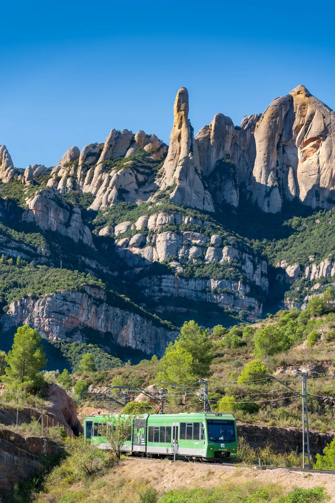
Sierra de Grazalema Loop - The Limestone Heart of Andalusia
The Sierra de Grazalema Loop is a breathtaking 85-kilometre journey through Spain's first natural park, a rugged landscape of jagged limestone peaks, deep emerald valleys, and the iconic "Pueblos Blancos" (White Villages). Located in the northeastern corner of the province of Cádiz and stretching into Málaga, this multi-day trek offers an immersive experience into a Mediterranean mountain world that feels remarkably ancient and untouched. The route circumnavigates the central massif of the Sierra, leading walkers through the rarest forest in Europe—the Spanish Fir (Pinsapo)—and across high-altitude karst plateaus where Griffon vultures soar on thermal currents. This is not the arid Spain of the coastal postcards; it is a land of high rainfall, lush cork oak forests, and hidden river canyons, where the scent of wild rosemary and rockrose fills the air and the hospitality of the mountain villages provides a warm, cultural counterpoint to the wild terrain.
- Distance: 85.0 km loop
- Duration: 5–7 days
- Season: March–May and September–November (avoiding the extreme summer heat)
- Accommodation: Village guesthouses (pensiones), small hotels, and mountain refugios
- Highest point: Puerto de las Presillas (1,250 m) or optional summit of El Torreón (1,654 m)
- Difficulty: Moderate (requires good fitness and navigation skills on rocky terrain)
- Direction: Traditionally walked anticlockwise starting from Grazalema
Overview
The Sierra de Grazalema is a geological masterpiece, a massive limestone fortress that rises abruptly from the rolling hills of Andalusia. Designated as a UNESCO Biosphere Reserve in 1977, the park is famous for its dramatic karst topography—a landscape shaped by the dissolution of soluble rocks, resulting in sinkholes, caves, and jagged ridges. The "Loop" is a curated route that connects the most significant villages and natural landmarks of the park, providing a comprehensive overview of the region's ecological and cultural diversity. Unlike many high-alpine treks, the Grazalema Loop balances wilderness immersion with the charm of Andalusian village life. Each day concludes in a white-washed settlement where narrow, cobblestone streets and flower-filled balconies offer a glimpse into a traditional way of life that has persisted for centuries.
The terrain is varied and demanding. Walkers will transition from the dense, humid shade of the Pinsapar forest—a relic from the Tertiary period—to the sun-scorched limestone pavements of the high sierras. The paths range from well-preserved Roman roads and medieval livestock tracks (cañadas reales) to faint, rocky trails marked only by stone cairns. Elevation gain is significant, with a total of 2,500 metres over the course of the journey, requiring steady legs and a comfortable pace. However, the rewards are immense: the sight of a colony of Griffon vultures nesting on the cliffs of Garganta Verde, the taste of locally produced Payoyo goat cheese in Villaluenga del Rosario, and the panoramic views from the high passes that stretch across the Serranía de Ronda to the Mediterranean Sea and, on clear days, the coast of Africa.
Water plays a central role in the identity of this range. Despite its southern latitude, Grazalema is famously the wettest place in Spain, receiving over 2,000 mm of rain annually. This high precipitation fuels a vibrant ecosystem, supporting one of the largest cork oak forests in the world and providing a sanctuary for diverse flora and fauna. The loop is designed to be flexible, allowing walkers to take five days for a brisk pace or seven days to truly savour the side trips and village culture. It is a journey of contrasts—between the grey of the limestone and the white of the villages, between the silence of the high peaks and the lively atmosphere of the village plazas.
History and Cultural Context
The history of the Sierra de Grazalema is a tapestry of Roman, Moorish, and Christian influences, all shaped by the rugged geography of the mountains. The region has been inhabited since prehistoric times, as evidenced by the Paleolithic paintings in the nearby Cueva de la Pileta. However, it was the Romans who first left a significant architectural mark, constructing the road that still connects Benaocaz to Ubrique. This "Calzada Romana" remains one of the best-preserved examples of Roman engineering in southern Spain, its stone pavers still bearing the weight of modern hikers and local livestock.
The Moorish era (8th to 15th centuries) defined the aesthetic and layout of the villages. The "Pueblos Blancos" were originally fortified settlements built on high ground for defensive purposes during the Reconquista. The narrow, winding streets were designed to provide shade and confuse invaders, while the thick stone walls, painted with white lime, served to reflect the intense summer sun. Grazalema itself, known as "Granadila" during the Nasrid Kingdom, became a centre for textile production, particularly high-quality wool blankets. This industry flourished for centuries, and even today, the local wool museum preserves the traditional looms and techniques that once clothed the Spanish royalty.
In the 19th century, the mountains became the legendary haunt of "bandoleros" (bandits). These outlaws, often romanticised in Spanish folklore, used the labyrinthine limestone caves and hidden valleys to evade the authorities while preying on travellers moving between Ronda and the coast. Today, the "Bandit Trail" is a popular theme for local tourism, but the true legacy of the region lies in its agricultural traditions. The "transhumance"—the seasonal movement of livestock—still dictates the rhythm of life for many locals, and the ancient rights of way used by shepherds form the backbone of the modern hiking network. Walking the Grazalema Loop is as much a journey through time as it is through nature.
Want more background? Read extended notes on history and cultural context → Learn more
Seasonal Highlights and Weather Reality
Timing is everything when planning a trek in the Sierra de Grazalema. The Mediterranean climate brings extreme contrasts, and the "Rainiest Place in Spain" moniker is no exaggeration during the winter months. Spring (March to May) is arguably the most spectacular time to visit. The wildflowers—including rare orchids, peonies, and irises—erupt in a riot of colour across the meadows, and the mountain streams are at their fullest. Temperatures are mild, typically ranging from 15°C to 22°C, making for ideal walking conditions. However, spring can also bring sudden, heavy rain showers, so waterproof gear remains essential.
Autumn (September to November) offers a different but equally compelling experience. The intense heat of summer begins to fade, and the landscape takes on golden hues as the deciduous trees in the valleys change colour. This is the season of the "berrea" (the rutting of the red deer), and the echoing calls of stags can often be heard in the quieter corners of the park. The air is often exceptionally clear in autumn, providing the best long-distance visibility for photography. Temperatures are similar to spring, though the evenings become noticeably crisper.
Summer (June to August) should be avoided by all but the most heat-tolerant walkers. Temperatures regularly exceed 35°C, and the limestone rock acts as a giant radiator, reflecting heat back at the hiker. Many water sources dry up, and the risk of forest fires often leads to the closure of key trails, including the Pinsapar and the ascent of El Torreón. Conversely, winter (December to February) can be surprisingly cold and wet. While snow is rare on the lower trails, the high passes can experience dusting, and the persistent rain can make the limestone paths dangerously slippery. If walking in winter, be prepared for short daylight hours and the closure of some seasonal guesthouses.
Recommended Itinerary
6-Day Sierra de Grazalema Loop Itinerary
Day 1: Grazalema to Benaocaz
- Distance: 14 km
- Elevation gain: 450 m
- Time: 5–6 hours
- Start in the centre of Grazalema, heading south towards the Boyar Pass
- Ascend through the limestone crags of the Sierra del Endrinal
- Pass the "Navazo Alto" high-altitude sinkhole meadow
- Descend into the historic village of Benaocaz, passing the ruins of the Moorish quarter (Barrio Nazarí)
- Key Waypoints: Puerto de las Presillas, Refugio de la Terriza (ruins), Fuente de San Fernando
- Stay: Local guesthouse in Benaocaz
Day 2: Benaocaz to Villaluenga del Rosario
- Distance: 12 km
- Elevation gain: 350 m
- Time: 4–5 hours
- Follow the ancient Roman Road (Calzada Romana) towards Ubrique
- Turn east to climb into the heart of the karst landscape
- Traverse the "Manga de Villaluenga," a dramatic tectonic valley
- Arrive in Villaluenga del Rosario, the highest village in the province
- Key Waypoints: Salto del Cabrero (Goat-herd's Leap) viewpoint, Ojo del Buey cave
- Stay: Traditional village house or small hotel in Villaluenga
Day 3: Villaluenga del Rosario to Montejaque
- Distance: 18 km
- Elevation gain: 600 m
- Time: 6–7 hours
- A long, wild day crossing the border from Cádiz into Málaga province
- Navigate the high plateaus of the Sierra de Líbar
- Pass through the Llanos de Libar, a vast, flat mountain meadow surrounded by peaks
- Descend via a steep, zig-zagging path into the hidden village of Montejaque
- Key Waypoints: Puerto del Correo, Llanos del Republicano, Ermita de Montejaque
- Stay: Posada or rural hotel in Montejaque
Day 4: Montejaque to Jimera de Líbar
- Distance: 15 km
- Elevation gain: 300 m
- Time: 5 hours
- Follow the Guadiaro River valley, a lush contrast to the high limestone
- Walk through ancient olive groves and cork oak forests
- Pass the Cueva del Gato (Cat's Cave), a spectacular river resurgence and swimming hole
- Arrive in the quiet village of Jimera de Líbar
- Key Waypoints: Estación de Benaoján, Guadiaro River path, Jimera station
- Stay: Rural accommodation in Jimera de Líbar
Day 5: Jimera de Líbar to Benaoján
- Distance: 12 km
- Elevation gain: 400 m
- Time: 4 hours
- Climb out of the valley for views back towards the Sierra de Grazalema
- Traverse the slopes of the Sierra del Palo
- Descend into Benaoján, famous for its cured meats and proximity to the Pileta Cave
- Optional: Afternoon visit to Cueva de la Pileta (prehistoric paintings - must book ahead)
- Key Waypoints: Mirador de Jimera, Benaoján village centre
- Stay: Hotel or guesthouse in Benaoján
Day 6: Benaoján to Grazalema
- Distance: 14 km
- Elevation gain: 400 m
- Time: 5–6 hours
- The final climb back into the central massif
- Follow the "Camino de los Charcones" alongside the Guadalete River
- Ascend through the cork oaks of the Monte de la Berruga
- Finish the loop with a grand entrance back into Grazalema
- Key Waypoints: Cueva del Gato (revisited), Puerto de los Alamillos, Grazalema Plaza
Important Notes:
- The route is not always signposted as a single "Loop"; it combines several PR (Pequeño Recorrido) and GR (Gran Recorrido) trails
- Water is scarce on the high plateaus; carry at least 3 litres per day
- The terrain is very rocky; sturdy boots with good grip are mandatory
- Mobile signal is intermittent in the deep valleys and high plateaus
Planning and Bookings
Book Your Trip
Everything you need to plan your journey
Accommodation
Find places to stay near Ronda
Flights
Search flights to Ronda
Essential Preparation
The Sierra de Grazalema Loop requires a moderate level of fitness and, more importantly, confidence in navigating rocky, uneven terrain. While the distances are not extreme, the "karst" limestone is sharp and can be slow-going. Before arriving, ensure you have downloaded offline maps (such as Wikiloc or AllTrails) as waymarking can be inconsistent. The logistical hub for the trek is the city of Ronda, which is well-connected to Málaga and Seville by bus and train. From Ronda, local buses run to Grazalema, though they are infrequent on weekends. It is highly recommended to spend a night in Grazalema before starting to acclimatise and pick up any last-minute supplies.
Booking coordination is vital if you are travelling during the peak spring or autumn seasons. While the villages have several accommodation options, they are small and can fill up quickly with weekend visitors from the cities. Most village guesthouses do not have sophisticated online booking systems; emailing or calling (often in basic Spanish) is sometimes necessary. Ensure you have a clear plan for each night's stay before you set off.
Trail Accommodation
Accommodation on the Grazalema Loop consists primarily of village-based guesthouses (pensiones), small boutique hotels, and "casas rurales" (rural houses). There are no high-altitude mountain huts in the style of the Alps or Pyrenees, which means you will enjoy a real bed and a hot shower most nights.
Village Guesthouses and Hotels:
- Facilities: Private or shared rooms, hot water, often include breakfast. Many have on-site restaurants serving local mountain cuisine.
- Costs: Expect to pay between €40 and €80 per night for a double room.
- Booking: Essential in peak season (April, May, October). Use platforms like Booking.com or contact local tourism offices.
Camping:
- Wild camping is strictly prohibited within the Natural Park boundaries.
- Official campsites exist near Grazalema (Camping Tajo Rodillo) and Benaoján, but they are not conveniently located for every night of the loop.
- If you choose to camp, you must stay in designated areas, which may require deviating from the main trail.
Required Gear
- Hiking Boots: Must have stiff soles and excellent ankle support. The limestone is notoriously sharp and can easily shred lightweight trainers.
- Navigation: A GPS device or a smartphone with offline maps and a power bank. A physical 1:25,000 scale map of the Sierra de Grazalema is highly recommended.
- Sun Protection: High-factor sunscreen, a wide-brimmed hat, and quality sunglasses. The reflection of the sun off the white limestone is intense.
- Clothing: Lightweight, breathable layers. Even in spring, midday temperatures can be hot, while evenings in the mountains are cool. A lightweight fleece and a windproof/waterproof shell are essential.
- Backpack: A 35–45 litre pack should be sufficient since you are not carrying camping gear or a week's worth of food.
What to Bring
- Water Capacity: At least two 1.5-litre bottles or a large hydration bladder. Natural springs (fuentes) exist but can be unreliable or dry in late spring and autumn.
- Water Treatment: Purification tablets or a filter (like a Sawyer Squeeze) for emergency use at livestock troughs.
- Food and Snacks: While you can buy dinner and breakfast in the villages, you should carry high-energy snacks (nuts, dried fruit, chocolate) and a packed lunch for the trail. Local "chorizo" and "queso de cabra" make excellent trail lunches.
- First Aid: Blister kits (Compeed), antiseptic wipes, ibuprofen, and any personal medications. An emergency whistle and space blanket are standard safety items.
- Cash: Many small village bars and guesthouses do not accept credit cards. Carry enough Euros to cover daily expenses.
Permits
For the general Sierra de Grazalema Loop, no overarching permit is required to walk the public trails and livestock routes. You are free to explore the majority of the park at your own pace. However, the park contains several "Reserve Zones" (Áreas de Reserva) that are strictly protected to preserve the fragile Pinsapo forest and nesting raptors. If your chosen route includes the Pinsapar Trail (between Grazalema and Benamahoma) or the ascent of El Torreón (the park's highest peak), you MUST obtain a free permit in advance.
How to obtain Reserve Zone permits:
- Permits are issued by the El Bosque Visitor Centre (Centro de Visitantes El Bosque).
- You can request them via email (cvelbosque@reservatuvisita.es) or by phone (+34 956 70 97 33).
- Requests should be made at least 15 days in advance during peak season, as daily quotas are strictly enforced (usually 30–60 people per day).
- You will need to provide your name, passport/ID number, the date of the hike, and the number of people in your group.
- During the high fire-risk season (typically June 1st to October 15th), these Reserve Zones are often closed entirely to the public.
General Park Rules: While no permit is needed for the main loop, you must adhere to park regulations: stay on marked trails, do not pick wildflowers, and keep dogs on a lead. The park rangers (Agentes de Medio Ambiente) do patrol the area, particularly the Reserve Zones, and will ask to see your permit if you are in a restricted area.
Other Activities in the Area
The region surrounding the Sierra de Grazalema is rich in cultural and outdoor opportunities. Consider adding a few days to your itinerary to explore:
- Ronda: One of Spain's most spectacular cities, perched on the edge of a 120-metre deep canyon (El Tajo). Visit the 18th-century Puente Nuevo bridge and one of the oldest bullrings in Spain.
- Caving and Canyoning: The limestone geology makes this a premier destination for subterranean exploration. The "Garganta Verde" is a world-class canyoning descent (permit required), while the "Cueva del Gato" offers a more accessible look at the park's hydrology.
- Cueva de la Pileta: Located near Benaoján, this privately owned cave contains some of the most important prehistoric wall paintings in Europe, dating back over 30,000 years. Tours are limited and must be booked in advance.
- Olive Oil Tours: The foothills of the Sierra are covered in olive groves. Many "almazaras" (oil mills) near Zahara de la Sierra offer tastings and tours explaining the production of liquid gold.
- Bird Watching: The park is a haven for ornithologists. Beyond the Griffon vultures, look for Bonelli's eagles, Egyptian vultures, and the colourful Hoopoe.
Safety and Conditions
Terrain Hazards: The primary safety concern on the Grazalema Loop is the terrain. The limestone is exceptionally sharp and, when wet, becomes as slippery as ice. Ankle injuries are the most common incident. Always maintain three points of contact on steep rocky sections and avoid hiking during heavy rain if your route involves significant limestone pavement (lapiaz).
Heat and Hydration: Even in the shoulder seasons, the Andalusian sun can be fierce. Heat exhaustion and dehydration are genuine risks. Start your walks early (before 8:00 AM) to complete the hardest climbs before the midday heat. Always carry more water than you think you need, as many mountain streams are seasonal and cannot be relied upon.
Navigation: While many trails are marked with green and white (PR) or red and white (GR) paint, these markings can be faded or confusing at junctions. In the high karst areas, the trail often disappears into a sea of grey rock, and you must rely on stone cairns (hitos). Always have a reliable GPS backup and know how to read a topographic map.
Wildlife: The park is home to wild mountain goats (Ibex), which are generally shy but can kick loose stones on steep slopes. Be mindful of where you stand if goats are above you. There are no dangerous predators, though the local "Mastín" shepherd dogs can be intimidating; if you encounter one guarding a flock, give it a wide berth and do not make eye contact.
Emergency Services: The emergency number in Spain is 112. Be aware that mountain rescue can be slow due to the rugged terrain. Always inform your guesthouse host of your intended route for the day.
Side Trips and Points of Interest
The Pinsapar Forest: This is the "holy grail" of the park. The Spanish Fir (Abies pinsapo) is a botanical rarity, a "living fossil" that survived the last ice age in these humid mountain pockets. Walking through the dense, dark forest feels like stepping into Northern Europe, a startling contrast to the surrounding Mediterranean scrub. The trail from Grazalema to Benamahoma through the Pinsapar is one of the most beautiful in Spain (Permit required).
El Torreón: At 1,654 metres, this is the highest peak in the province of Cádiz. The ascent is short but very steep, involving some light scrambling. From the summit, the views are unparalleled: the entire Sierra de Grazalema is laid out below you, with the Rock of Gibraltar and the Atlas Mountains of Morocco visible on the horizon (Permit required).
Garganta Verde: A spectacular "Green Throat" canyon with vertical walls rising 400 metres. It is home to one of the largest colonies of Griffon vultures in Europe. Even if you don't do the full canyoning descent, the hike to the "Ermita de la Garganta" (a massive natural cave at the bottom) is an unforgettable experience (Permit required).
Salto del Cabrero: A geological fault that has created two massive vertical cliffs separated by a narrow gap. Legend says a goat-herd once leaped across the chasm to escape his pursuers. It is a fantastic spot for photography and watching vultures at eye level.
Leave No Trace
The Sierra de Grazalema is a fragile ecosystem under increasing pressure from tourism. As a walker, you have a responsibility to minimise your impact on this UNESCO Biosphere Reserve.
Core Principles for the Sierra:
- Stick to the Path: In karst areas, the soil is thin and easily eroded. Straying from the trail destroys the specialized plants that grow in the rock crevices.
- Manage Your Waste: There are no bins on the trail. Pack out all litter, including organic waste like orange peels and nut shells, which decompose slowly in the arid environment and can harm local wildlife.
- Respect the Water: Do not use soaps or detergents in mountain springs or troughs. These are vital drinking sources for both wildlife and livestock.
- No Fire: The risk of forest fire in Andalusia is extreme. Never light a fire and be extremely careful with cigarette butts (better yet, don't smoke on the trail).
- Respect the Silence: The mountains are a sanctuary. Avoid loud music or shouting, which can disturb nesting birds and other hikers.
- Gate Etiquette: You will pass through many livestock gates. Always leave them as you found them (usually closed) to prevent cattle and goats from wandering.