Sentiero Cristallina - The Crystal Path
The Sentiero Cristallina, or Crystal Path, is a challenging yet immensely rewarding mountain track traversing the heart of the Swiss Alps. This demanding route winds through dramatic alpine landscapes, past shimmering glacial lakes, over rugged passes, and through remote valleys, offering a true test of endurance and a profound connection with the high mountain environment. It is a journey that demands respect for the elements and rewards the determined with unparalleled vistas and a sense of accomplishment.
- Distance: 62.0 km one-way
- Duration: 4–5 days
- Season: July to September
- Difficulty: Challenging
- Highest point: Passo Cristallina (approx. 2,300 m)
- Starting point: Airolo
- Ending point: Disentis/Mustér
- Accommodation: Mountain huts and bivouacs
Overview
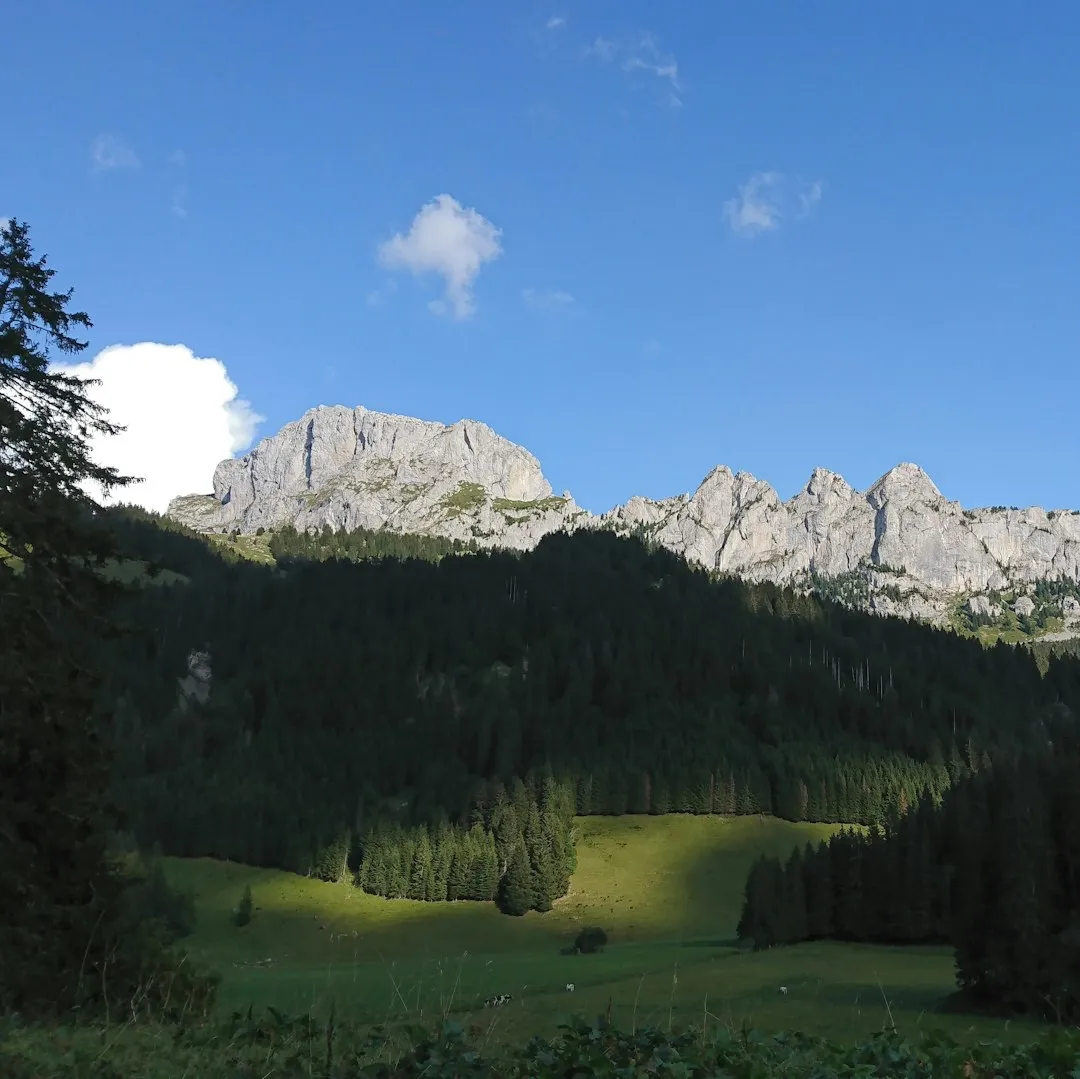
The Sentiero Cristallina is a classic alpine traverse that showcases the raw beauty and rugged character of the Swiss Alps. Beginning in the Ticino canton and concluding in the Grisons, the trail offers a diverse range of scenery, from the granite peaks and alpine meadows of the south to the more glaciated and dramatic landscapes of the north. The trail is characterised by steep ascents and descents, rocky terrain, and exposed sections, making it suitable for experienced hikers with a good level of fitness and a head for heights.
The name "Cristallina" hints at the many crystal-clear alpine lakes and streams that punctuate the route, reflecting the surrounding snow-capped peaks and azure skies. The trail often follows ancient mule tracks and shepherd paths, offering a glimpse into the historical human interaction with this formidable mountain environment. Hikers can expect to encounter a variety of flora and fauna, including marmots, chamois, and a rich array of alpine wildflowers during the summer months.
This is not a walk for the faint-hearted. It requires careful planning, robust gear, and a solid understanding of mountain safety. However, for those who are prepared, the Sentiero Cristallina offers an unforgettable adventure, a chance to disconnect from the everyday and immerse oneself in the grandeur of the Alps.
History and Cultural Context
The Sentiero Cristallina follows routes that have been used for centuries by local communities, shepherds, and traders. The passes and valleys it traverses were vital links between the Italian-speaking Ticino and the Romansh-speaking Grisons, facilitating the movement of goods, livestock, and people. These ancient pathways, often little more than rough mule tracks, were essential for the economic and social life of the region.
The construction of mountain huts and the formalisation of some sections of the trail are more recent developments, often driven by the burgeoning interest in alpine tourism and mountaineering in the late 19th and early 20th centuries. These efforts aimed to make the high mountain regions more accessible to a wider audience, while still preserving the wild character of the landscape.
The region is rich in cultural heritage, with distinct linguistic and architectural traditions in both Ticino and Grisons. The trail passes through small alpine villages where traditional stone houses and churches stand testament to a long history of human settlement in challenging terrain. The presence of old fortifications and remnants of past mining activities also hint at the strategic importance and resourcefulness of the people who have inhabited these mountains.
Seasonal Highlights and Weather Reality
The optimal season for hiking the Sentiero Cristallina is from July to September. During these months, the snow has generally receded from the higher passes, and the weather is typically more stable, although alpine conditions can change rapidly at any time.
July: The alpine meadows are often at their most vibrant, bursting with wildflowers. The days are long, providing ample daylight for hiking. However, early July can still see lingering snow on shaded slopes and at higher elevations, and some higher passes might still be challenging.
August: This is generally considered the peak season. The weather is often at its most settled, and the trail is usually clear of snow. The lakes are at their most inviting, and the mountain scenery is spectacular. However, August can also be the busiest month, and accommodation in huts should be booked well in advance.
September: The autumn colours begin to appear in the lower valleys, offering a different kind of beauty. The air is crisp, and the crowds tend to thin out. However, the days are shorter, and the risk of early snowfall on the higher passes increases as the month progresses. Temperatures can drop significantly, especially at night.
Weather: The Swiss Alps are known for their unpredictable weather. Even in summer, hikers can encounter rain, fog, strong winds, and even snow. Temperatures can fluctuate dramatically between day and night, and at higher altitudes. It is crucial to be prepared for all conditions, regardless of the season.
Recommended Itinerary
4-Day Sentiero Cristallina Itinerary
Day 1: Airolo to Capanna Corno Gries
- Distance: 15 km
- Elevation gain: 1,200 m
- Time: 5–6 hours
- Start in Airolo (1,141 m)
- Ascend through alpine pastures and larch forests
- Pass the Lago di Morghirolo
- Reach Capanna Corno Gries (2,000 m)
- This day involves a significant climb, acclimatising you to the altitude and the rugged terrain.
- The hut offers basic but comfortable accommodation and stunning views of the surrounding peaks.
Day 2: Capanna Corno Gries to Capanna Cristallina
- Distance: 12 km
- Elevation gain: 700 m, Elevation loss: 400 m
- Time: 4–5 hours
- Cross the Passo di Gries (2,479 m)
- Descend towards the Lago di Nufenen
- Ascend to Capanna Cristallina (2,100 m)
- This day features a high pass crossing with panoramic views, followed by a descent and then another ascent to the next hut.
- The landscape becomes more rugged and exposed.
Day 3: Capanna Cristallina to Rifugio Basodino
- Distance: 14 km
- Elevation gain: 600 m, Elevation loss: 800 m
- Time: 5–6 hours
- Ascend to the Passo Cristallina (approx. 2,300 m)
- Descend through a dramatic valley
- Pass the Lago dei Cristallina
- Reach Rifugio Basodino (1,850 m)
- This day involves crossing the namesake pass and offers spectacular views of glacial features and alpine lakes.
- The descent can be steep and rocky.
Day 4: Rifugio Basodino to Disentis/Mustér
- Distance: 21 km
- Elevation gain: 500 m, Elevation loss: 1,000 m
- Time: 6–7 hours
- Descend from Rifugio Basodino
- Follow the river valley towards Disentis/Mustér
- The final section is a long descent into the valley, transitioning from high alpine terrain to more cultivated landscapes.
- Arrive in Disentis/Mustér (1,130 m), a historic Benedictine monastery town.
- This is the longest day, but the gradient is generally favourable for the majority of the route.
Alternative 5-Day Itinerary:
For a more relaxed pace or to allow for more exploration, consider splitting Day 4 into two shorter days, perhaps staying overnight at a smaller bivouac or guesthouse closer to Disentis/Mustér.
Important Notes:
- Hut bookings are essential, especially during peak season (July-August).
- Check weather forecasts daily and be prepared for rapid changes.
- Carry sufficient water or a reliable water filter/purification method.
- Inform someone of your itinerary and expected return time.
- This trail is not suitable for beginners or those with a fear of heights.
Planning and Bookings
Book Your Trip
Everything you need to plan your journey
Accommodation
Find places to stay near Bellinzona
Flights
Search flights to Bellinzona
Essential Preparation
The Sentiero Cristallina is a serious alpine trek requiring thorough preparation. Before embarking, ensure you have a good level of physical fitness, with experience in multi-day hiking and navigating challenging terrain. Familiarise yourself with map reading and compass use, as mobile phone reception can be unreliable in remote areas.
The closest major city with an international airport is Zurich (ZRH). From Zurich, take a train to Bellinzona (approx. 2 hours) and then a regional train or bus to Airolo (approx. 1 hour), the primary trailhead. Alternatively, you can drive from Zurich to Airolo (approx. 2 hours). For the end of the trail, Disentis/Mustér is well-connected by train, with regular services to Zurich and other major Swiss cities.
It is highly recommended to spend at least one night in Airolo before starting your trek to acclimatise and make any last-minute preparations. Similarly, allow for a day in Disentis/Mustér after your hike to rest and arrange onward travel.
Trail Accommodation
The Sentiero Cristallina primarily utilises a network of mountain huts (Capanna/Hütte/Rifugio) and bivouacs operated by local Swiss Alpine Club (SAC) sections or private entities. These offer basic but essential shelter and amenities for hikers.
Hut Facilities:
- Dormitory-style sleeping quarters with mattresses and blankets (a sleeping bag liner is mandatory).
- Communal dining areas.
- Basic cooking facilities (often gas stoves, but bring your own pots and utensils).
- Access to water (usually from springs or streams; treatment is recommended).
- Toilets (often pit toilets or composting toilets).
- Some huts may offer limited charging facilities for electronic devices, but this should not be relied upon.
What Huts Don't Provide:
- Food and drinks (though many huts offer meals and refreshments for purchase).
- Pillows or sleeping bag liners (bring your own).
- Cooking equipment (pots, pans, cutlery, plates, cups).
- Electricity for extensive charging.
- Hot showers (rare, and usually only available at larger, more established huts).
Booking Requirements:
- Booking is highly recommended, especially during the peak season (July and August). Many huts are small and can fill up quickly.
- Contact the specific hut directly to make a reservation. Websites for SAC huts are usually available online.
- Costs vary but typically range from CHF 30-60 per person per night for non-members, with discounts for SAC members.
Bivouacs: Some sections of the trail may pass near bivouacs, which are very basic shelters offering minimal protection from the elements. These are typically unmanned and intended for emergency use or for very experienced, self-sufficient hikers.
Required Gear
- Sturdy hiking boots: Waterproof, with good ankle support and a well-worn sole.
- Waterproof and windproof jacket and trousers: Essential for protection against sudden alpine weather changes.
- Warm layers: Fleece or down jacket, thermal base layers (merino wool is ideal).
- Hat and gloves: Even in summer, temperatures can drop significantly at altitude.
- Backpack: 40-60 litre capacity, with a rain cover.
- Sleeping bag liner: Mandatory for use in huts.
- Head torch: With spare batteries, for use in huts and for early morning/late evening hiking.
- First-aid kit: Including blister treatment, pain relievers, antiseptic wipes, and any personal medications.
- Navigation tools: Detailed topographic maps of the area, a compass, and a GPS device or smartphone with offline maps.
- Sun protection: High SPF sunscreen, sunglasses, and a wide-brimmed hat.
- Trekking poles: Highly recommended for stability on steep ascents and descents.
What to Bring
- Food: Sufficient high-energy food for the duration of the trek, including snacks. While some huts offer meals, it's wise to carry your own provisions.
- Water bottle or hydration reservoir: At least 2 litres capacity.
- Water purification method: Filter or purification tablets, as stream water should be treated.
- Personal toiletries: Biodegradable soap, toothbrush, toothpaste, small towel.
- Camera: To capture the stunning scenery.
- Cash: For hut fees, meals, and any unexpected expenses. Credit card facilities are not always available in remote huts.
- Personal identification and travel documents.
- Small repair kit: Including duct tape and safety pins.
Permits
The Sentiero Cristallina does not require specific permits for hiking. However, access to and use of mountain huts operated by the Swiss Alpine Club (SAC) or other organisations typically involves a fee and often requires advance booking, especially during the peak summer season (July and August).
Hut Reservations:
- It is strongly advised to book your accommodation in mountain huts well in advance. Huts can be small, and popular routes fill up quickly.
- Reservations can usually be made directly with the hut guardian or through the website of the relevant SAC section.
- When booking, be prepared to provide your name, the number of people in your party, your desired dates, and whether you are an SAC member.
- Some huts may offer half-board options (dinner and breakfast), which can be a convenient way to manage your food supplies.
Costs:
- Hut fees vary but typically range from CHF 30 to CHF 60 per person per night for non-members.
- SAC members receive a discount.
- Children and students may also be eligible for reduced rates.
- Meals, if purchased, are additional.
Important Considerations:
- Always carry enough cash to pay for your accommodation and any food or drinks, as credit card facilities are not always available in remote mountain huts.
- Familiarise yourself with the specific rules and etiquette of the huts you plan to stay in.
- Ensure you have a reliable way to contact huts for reservations or in case of emergencies.
Other Activities in the Area
The regions surrounding the Sentiero Cristallina offer a wealth of activities for those looking to extend their stay or explore beyond the trail:
- Exploring Airolo: Visit the historic town centre, discover its traditional architecture, and learn about its history at the local museum. The Gotthard Pass, a significant historical route, is also nearby and accessible for day trips.
- Disentis Abbey: The Benedictine monastery in Disentis/Mustér is a major cultural and spiritual centre. Visitors can explore the abbey church, museum, and enjoy the peaceful atmosphere.
- Cable Car Rides: Several cable cars operate in the vicinity, offering spectacular panoramic views without the strenuous climb. These can be a great way to access high-altitude viewpoints or start shorter hikes.
- Cycling: The valleys are well-suited for road cycling, with scenic routes and challenging climbs for enthusiasts.
- Via Ferrata: For the adventurous, there are several via ferrata routes in the Ticino and Grisons regions, offering a thrilling way to experience the mountains.
- Lake Maggiore: If time permits, a visit to the Italian-speaking region of Ticino would not be complete without experiencing the charm of Lake Maggiore, with its picturesque towns and islands.
Safety and Conditions
Weather: Alpine weather is notoriously unpredictable. Always check the latest mountain weather forecast (e.g., from MeteoSwiss) before and during your hike. Be prepared for rapid changes, including rain, fog, strong winds, and even snow, regardless of the season.
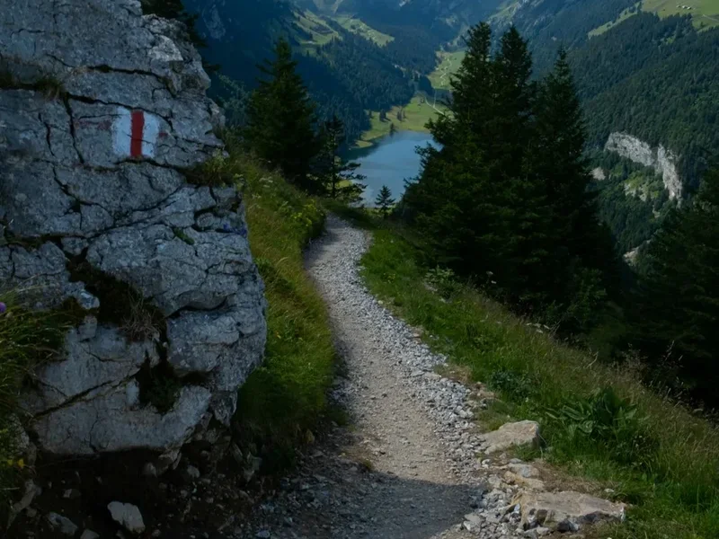
Terrain: The Sentiero Cristallina involves steep ascents and descents, rocky and uneven paths, scree slopes, and potentially exposed sections. Good hiking boots with ankle support are essential. Trekking poles can significantly improve stability and reduce strain on joints.
Altitude: The trail reaches significant altitudes (over 2,300 metres). Acclimatise properly by spending time at altitude before starting the trek. Be aware of the symptoms of altitude sickness (headache, nausea, dizziness) and descend if symptoms worsen.
Navigation: While the trail is generally well-marked, it is crucial to carry detailed topographic maps and a compass, and know how to use them. GPS devices or smartphone apps with offline maps are also valuable tools. Do not rely solely on mobile phone reception, as it can be intermittent in mountainous areas.
Water: Water sources are generally available along the trail, but it is always recommended to treat water from streams and springs using a filter or purification tablets to avoid waterborne illnesses.
Communication: Mobile phone coverage can be unreliable. Consider carrying a personal locator beacon (PLB) or satellite messenger for emergencies, especially if hiking alone.
Emergency Contacts: Know the emergency numbers for Switzerland (144 for medical emergencies, 112 for general emergencies). Inform someone of your hiking plans, including your intended route and expected return time.
Hut Etiquette: Respect the rules of the mountain huts. Keep noise levels down, especially during sleeping hours, and follow the instructions of the hut guardian.
Wildlife: While generally shy, be aware of local wildlife such as marmots and chamois. Do not feed wild animals.
Side Trips and Points of Interest
Lago di Morghirolo: A beautiful alpine lake encountered on the first day, offering a serene spot for a break and reflection amidst the rising terrain.
Passo di Gries: This high pass marks a significant point on the trail, offering expansive panoramic views across the surrounding mountain ranges. It's a prime location for photography and appreciating the scale of the Alps.
Lago di Nufenen: A picturesque lake situated near the Passo di Gries, often reflecting the dramatic mountain scenery. Its clear waters are a testament to the pristine alpine environment.
Lago dei Cristallina: This stunning lake, giving the trail its name, is a highlight of the trek. Its crystal-clear waters and surrounding granite peaks create a breathtaking vista, especially on a clear day.
Disentis Abbey: While at the end of the trail, the historic Benedictine monastery in Disentis/Mustér is a significant cultural landmark worth exploring. Its impressive architecture and rich history offer a fascinating contrast to the wild mountain landscapes.
Local Villages: The small villages passed through or near the trail, such as Airolo and Disentis/Mustér, offer insights into traditional Swiss alpine life, with their distinctive architecture and local customs.
Leave No Trace
The Sentiero Cristallina traverses fragile alpine ecosystems. Adhering to Leave No Trace principles is paramount to preserving the natural beauty and ecological integrity of this environment for future generations.
Plan Ahead and Prepare: Research the trail, understand its challenges, and be prepared for all weather conditions. Pack appropriately and know your limits.
Travel and Camp on Durable Surfaces: Stick to marked trails to avoid damaging vegetation. Where camping is permitted (though not generally on this route, as huts are the primary accommodation), choose established campsites or durable surfaces like rock or gravel.
Dispose of Waste Properly: Pack out everything you pack in, including all food scraps, wrappers, and any other litter. Use designated toilet facilities in huts. If no facilities are available, dig a cathole at least 60 metres away from water sources, trails, and campsites.
Leave What You Find: Do not remove or disturb natural objects, plants, or cultural artefacts. Take only photographs and memories.
Minimise Campfire Impacts: Campfires are generally not permitted on alpine trails due to the risk of environmental damage and fire hazards. Use a portable stove for cooking.
Respect Wildlife: Observe wildlife from a distance and never feed animals. Feeding wildlife can disrupt their natural behaviours and diets, and can make them dependent on humans.
Be Considerate of Other Visitors: Keep noise levels down, yield to other hikers on narrow trails, and maintain a respectful attitude towards fellow trekkers and locals.