Sarek National Park Trail - Europe's Last Great Wilderness
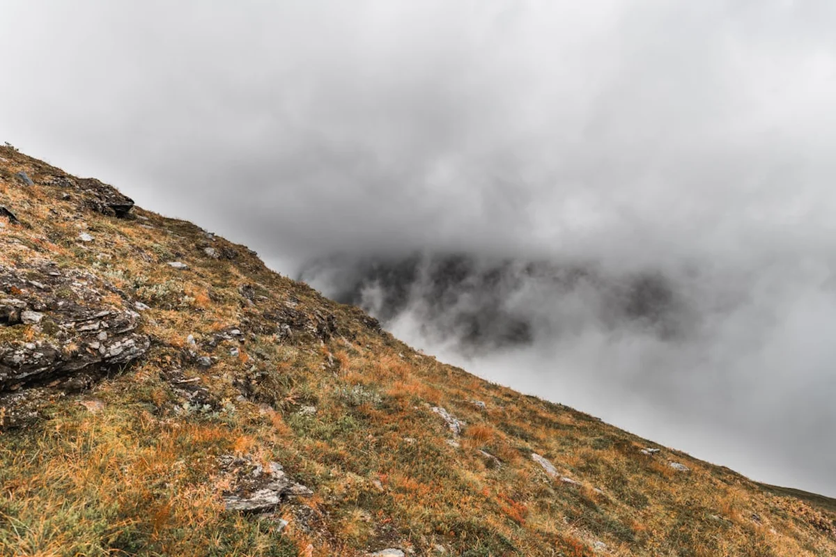
Sarek National Park is often described as the "Last Wilderness of Europe," a title it earns through its sheer isolation, lack of infrastructure, and raw, untamed beauty. Located in the far north of Swedish Lapland, within the Arctic Circle, Sarek is a high-alpine landscape that remains largely untouched by modern development. Unlike most national parks, Sarek has no marked trails, no cabins for overnight stays within its interior, and very few bridges over its powerful glacial rivers. A trek through Sarek is not merely a hike; it is an expedition that demands self-sufficiency, advanced navigation skills, and a deep respect for the unpredictable forces of nature. Spanning approximately 105 kilometres depending on the chosen route, this journey takes trekkers through deep U-shaped valleys, past massive glaciers, and beneath some of Sweden's highest and most jagged peaks.
The park is part of the Laponian Area, a UNESCO World Heritage site that recognises both its unique natural values and its profound cultural significance to the Sami people, who have herded reindeer in these mountains for millennia. For the modern adventurer, Sarek offers a rare opportunity to experience a landscape where the human footprint is almost invisible. There are no signposts to guide you, no mobile phone reception to call for help, and no easy exits. It is a place where the rhythm of the day is dictated by the weather and the terrain, offering a profound sense of solitude and a connection to the earth that is increasingly difficult to find in the 21st century. This is a trek for those who seek to test their limits in one of the most spectacular and demanding environments on the planet.
- Distance: Approximately 105.0 km (variable based on route choice)
- Duration: 7–10 days
- Season: July to September (summer months)
- Accommodation: Wild camping only (no huts within park boundaries)
- Highest point: Route dependent; passes typically reach 1,200–1,400 m
- Difficulty: Very Challenging (requires off-trail navigation and river wading)
- Direction: Flexible, but commonly hiked from Aktse (South) to Ritsem (North)
Overview
Sarek National Park is a bastion of high-alpine wilderness, covering 1,970 square kilometres of rugged terrain. It is defined by its "Big Six"—the six peaks in Sweden that exceed 2,000 metres in height, all of which are found within or on the borders of the park. The landscape is a dramatic tapestry of nearly 100 glaciers, narrow valleys, and turbulent rivers fed by meltwater. The most iconic of these is the Rapadalen (Rapa Valley), a 35-kilometre-long glacial trough that features the spectacular Rapa River delta, where the water winds through a mosaic of silt deposits and lush vegetation, creating one of the most photographed natural features in Scandinavia.
The experience of trekking in Sarek is fundamentally different from hiking on the Kungsleden (King's Trail) or other established European routes. In Sarek, the "trail" is often nothing more than a faint reindeer path that disappears into a boulder field or a dense thicket of willow scrub. Progress is measured not just in kilometres, but in the successful negotiation of obstacles. A single river crossing can take hours of scouting to find a safe passage, and a sudden Arctic storm can pin a group in their tents for days. This lack of infrastructure is intentional; the Swedish Environmental Protection Agency maintains Sarek as a wilderness area where nature is allowed to take its course with minimal human interference.
The flora and fauna of Sarek are equally impressive. The lower valleys are home to ancient birch forests and lush meadows that support a variety of wildlife, including the "Sarek Giants"—exceptionally large moose (elk) that are known for their lack of fear toward humans due to the absence of hunting. You may also encounter reindeer, golden eagles, and, if you are extremely lucky, the elusive wolverine or lynx. The geological history of the park is written in its stones; the deep valleys were carved by massive ice sheets during the last ice age, leaving behind a landscape of staggering scale. To walk through Sarek is to step back in time, experiencing the world as it was before the advent of roads and permanent settlements.
Because there are no fixed itineraries, every trekker's experience is unique. Whether you choose to follow the high plateaus for panoramic views or navigate the lush, challenging valley floors, Sarek requires a level of preparation and mental fortitude that few other trails demand. It is a place of immense silence, broken only by the roar of waterfalls and the whistling of the wind through the crags. For those prepared for its challenges, Sarek offers a reward that is commensurate with its difficulty: a sense of true freedom in one of the world's last great wild places.
History and Cultural Context
The history of Sarek is inextricably linked to the Sami people, the indigenous inhabitants of northern Scandinavia. For thousands of years, the Sami have lived in harmony with this harsh environment, following the seasonal migrations of reindeer. Sarek is not an empty wilderness to the Sami; it is a cultural landscape filled with names, stories, and sacred sites. The park remains an active reindeer herding area, and trekkers will often see reindeer grazing on the high slopes or find the remains of traditional Sami hearths and storage pits. The respect for this living culture is a cornerstone of visiting Sarek; hikers are guests in a land that has provided sustenance and spiritual meaning to the Sami for generations.
In the late 19th and early 20th centuries, Sarek began to attract the attention of European scientists and explorers. The most prominent figure in Sarek's modern history is Axel Hamberg, a Swedish professor of geography and geology. Starting in 1895, Hamberg spent over 30 years studying the park's glaciers, climate, and geology. He established several small research stations (some of which still stand as historical relics) and produced the first detailed maps of the region. Hamberg’s work was instrumental in the establishment of Sarek as one of Europe's first national parks in 1909. His dedication to the area helped preserve it from the hydroelectric developments that transformed many other Swedish mountain valleys during the 20th century.
In 1996, Sarek was included in the Laponia World Heritage site, a designation that covers 9,400 square kilometres and includes three other national parks and two nature reserves. This UNESCO status recognises Laponia as the largest area in the world with an ancestral way of life based on the seasonal movement of livestock. Today, Sarek stands as a symbol of conservation, balancing the protection of a unique ecosystem with the continued traditional use of the land by the Sami. The history of the park is a reminder that wilderness is not just a lack of people, but a specific relationship between humans and the natural world—one based on endurance, adaptation, and profound respect.
Want more background? Read extended notes on history and cultural context → Learn more
Seasonal Highlights and Weather Reality
The window for trekking in Sarek is narrow, dictated by the extreme Arctic climate. The summer season typically runs from early July to mid-September. Outside of this period, Sarek is a world of ice and snow, accessible only to experienced winter expeditioners with specialised equipment and skills.
July: This is the month of the Midnight Sun, where the sun never fully sets, providing 24 hours of daylight for trekking. The landscape is vibrant and green, and the wildflowers are in full bloom. However, July is also the peak season for mosquitoes and biting midges, which can be relentless in the lower, boggy valleys. Snow patches may still linger on high passes, and river levels are often at their highest due to the late snowmelt, making crossings particularly hazardous.
August: Often considered the best month for Sarek, August sees a decrease in insect activity and more stable river levels. The days remain long, though the sun begins to dip below the horizon for a few hours each night. The weather can still be highly unpredictable, with sudden shifts from warm sunshine to freezing rain. Towards the end of August, the first hints of autumn appear as the dwarf birch and willow begin to turn gold.
September: This is the season of "Ruska," the spectacular autumn colour change. The tundra turns shades of brilliant red, orange, and gold, and the air becomes crisp and clear. The mosquitoes are gone, and the first dustings of new snow may appear on the peaks. September also brings the return of the Aurora Borealis (Northern Lights) as the nights grow longer. However, the weather becomes significantly more volatile, with a higher risk of autumn storms and sub-zero temperatures. Most boat transfers (essential for accessing the park) cease operations by the third week of September.
Regardless of the month, weather in Sarek is notoriously fickle. The park acts as a "weather hole," where systems from the Atlantic and the Arctic collide. It is common to experience four seasons in a single day. High winds are a constant threat, and horizontal rain can soak even the best gear. Trekkers must be prepared for the reality that they may spend 24 to 48 hours confined to their tent waiting for a storm to pass. Flexibility is the most important piece of equipment you can bring to Sarek.
Recommended Itinerary
8-Day Sarek Traverse: Aktse to Ritsem
Day 1: Aktse to the Skierfe Massif
- Distance: 12 km
- Elevation gain: 600 m
- Time: 5–6 hours
- Start at Aktse (accessible by boat from Sitojaure or via the Kungsleden)
- Steep climb out of the birch forest onto the alpine plateau
- Set up camp near the base of Skierfe
- Evening hike to the summit of Skierfe (1,179 m) for the iconic view of the Rapadalen Delta
- The sheer 700-metre drop from the summit to the river below is one of the most dramatic sights in Sweden
Day 2: Skierfe to the Central Rapa Valley (Rapadalen)
- Distance: 15 km
- Elevation: 200 m gain, 400 m descent
- Time: 7–8 hours
- Descend into the upper Rapadalen, navigating dense willow scrub and birch forest
- Follow faint animal paths along the north side of the Rapa River
- This is "moose country"—keep a lookout for the Sarek Giants
- Camp near the confluence of the Laitaure and Rapa rivers
- Progress can be slow due to thick vegetation and boggy ground
Day 3: Rapadalen to Skårki
- Distance: 14 km
- Elevation gain: 300 m
- Time: 6–7 hours
- Continue up the valley towards the heart of the park
- Pass the historic Axel Hamberg research hut at Skårki (for emergency use only)
- The valley narrows here, with the massive Sarektjåkkå massif looming to the north
- River crossings become more frequent as side streams feed into the Rapaätno
- Camp in the vicinity of the Skårki bridge (one of the few in the park)
Day 4: Skårki to Pielaslätten
- Distance: 13 km
- Elevation gain: 400 m
- Time: 6–7 hours
- Leave the dense vegetation of the lower valley and climb onto the Pielaslätten plateau
- This high-altitude plain offers easier walking and 360-degree views of the surrounding glaciers
- Pass beneath the jagged peaks of the Pierikpakte
- Camp near the shores of Pielajåhkå, with views of the glaciers of the Sarek massif
- The exposure to wind increases significantly on this open plateau
Day 5: Pielaslätten to Guhkesvagge
- Distance: 16 km
- Elevation: 300 m gain, 200 m descent
- Time: 7–8 hours
- Cross the high pass into the Guhkesvagge valley
- This section involves navigating large boulder fields and potentially crossing snow patches
- The Guhkesvakkjåhkå river must be crossed; this is a major glacial river and requires extreme caution
- Camp on the northern side of the river with views towards the Akka massif
- The landscape here is stark, rocky, and quintessentially Arctic
Day 6: Guhkesvagge to Nijak
- Distance: 14 km
- Elevation gain: 200 m
- Time: 5–6 hours
- Follow the northern edge of the Sarek massif towards the peak of Nijak
- The terrain is a mix of tundra and rock, with several smaller stream crossings
- Nijak is a distinctive, pyramid-shaped peak that serves as a constant landmark
- Camp near the base of Nijak, where the Ruohtesvagge valley begins
- This area is often frequented by large herds of reindeer
Day 7: Nijak to Kisuris
- Distance: 15 km
- Elevation: 400 m descent
- Time: 6–7 hours
- Descend through the Ruohtesvagge valley towards the park boundary
- The terrain becomes greener as you lose elevation, returning to birch forest
- Cross the boundary out of Sarek National Park and into Padjelanta National Park
- Camp near the Kisuris huts (STF), where the first signs of infrastructure reappear
- Enjoy the relative luxury of a designated campsite and the company of other hikers
Day 8: Kisuris to Akka and Ritsem
- Distance: 14 km
- Elevation: 100 m descent
- Time: 4–5 hours
- Follow the well-marked Padjelantaleden trail towards the Akka huts
- The walking is fast and easy on maintained paths and boardwalks
- Arrive at the Akka jetty for the boat transfer across Lake Akkajaure to Ritsem
- The boat journey offers a final, stunning view of the "Queen of Lapland"—the Akka massif
- Finish in Ritsem, where a bus connects back to Gällivare and the rail network
Important Notes:
- This itinerary is a suggestion only; Sarek requires daily adjustments based on weather and river conditions
- There are no resupply points; you must carry all food for the duration
- Navigation is entirely by map and compass/GPS; do not expect to find a trail
- River crossings are the most dangerous part of the trek; never cross alone if possible
- Always have a "Plan B" route in case a river is impassable or a pass is blocked by weather
Planning and Bookings
Book Your Trip
Everything you need to plan your journey
Accommodation
Find places to stay near Jokkmokk
Flights
Search flights to Jokkmokk
Essential Preparation
Planning a trip to Sarek is a significant undertaking that should begin months in advance. Because there are no marked trails or huts, your primary preparation must focus on two areas: navigation and physical conditioning. You must be proficient in reading topographic maps and using a compass, as GPS devices can fail in the deep valleys or due to battery exhaustion in the cold. Physical fitness is paramount; you will be carrying a heavy pack (typically 18–25 kg) over uneven, trackless terrain, including bogs, boulder fields, and thick scrub.
Logistically, the gateway to Sarek is the town of Jokkmokk. From here, you can access the various trailheads via bus and boat. Most trekkers arrive in the region via the night train from Stockholm to Gällivare or Murjek, followed by a bus. Coordination of boat transfers is critical; many of the entry points, such as Aktse or the crossing of Lake Akkajaure, rely on seasonal boat services operated by local Sami families or the STF. Check the latest timetables on the Laponia or STF websites, as these can change based on water levels and weather.
Trail Accommodation
Within the boundaries of Sarek National Park, there is no formal accommodation. There are no huts, no shelters, and no designated campsites. You are required to wild camp for the duration of your time inside the park.
Camping in Sarek:
- You may pitch your tent anywhere, provided you follow Leave No Trace principles
- Look for established "impact zones" where others have camped to minimise further damage to vegetation
- Avoid camping in narrow valley bottoms where cold air settles or near rivers that may rise rapidly overnight
- A high-quality, 4-season tent is essential to withstand the potential for extreme Arctic winds
Border Huts (STF):
- Huts are located just outside the park boundaries: Aktse, Sitojaure, Saltoluokta, Akka, and Kisuris
- These huts offer bunks, kitchens, and small shops (limited supplies)
- They are excellent for the first or last night of your trip but are not accessible once you are deep in Sarek
- Bookings for STF huts are recommended during the peak season but not strictly mandatory for camping near them
Required Gear
- Tent: A sturdy, wind-resistant 4-season tent. Sarek is no place for a lightweight "fair weather" shelter.
- Backpack: 65–85L capacity with a robust suspension system to handle heavy loads. A waterproof liner or high-quality rain cover is mandatory.
- Boots: High-cut, waterproof leather boots with stiff soles for boulder hopping and ankle support. Many Swedish hikers prefer "shell boots" (Lundhags style) which do not have a waterproof membrane but dry faster.
- Navigation: 1:50,000 scale topographic maps (Calazo or Lantmäteriet), a reliable compass, and a GPS with offline maps.
- River Crossing Gear: A pair of lightweight, secure sandals or neoprene boots and a set of trekking poles (essential for stability in fast-moving water).
- Satellite Communicator: A Garmin inReach or similar device. There is zero mobile coverage in Sarek, and an emergency beacon is your only link to rescue services.
- Stove and Fuel: A reliable multi-fuel or gas stove. Gas canisters can be purchased in Jokkmokk, Gällivare, or at STF mountain stations.
What to Bring
- Food: High-calorie, lightweight dehydrated meals for 8–10 days, plus 2 days of emergency rations. Include plenty of fats (nuts, chocolate, butter) to maintain body heat.
- Water Treatment: While most water in Sarek is pristine glacial melt, a lightweight filter or chlorine tablets are recommended if camping near high-use areas or downstream of large reindeer herds.
- Clothing Layers: Merino wool base layers (two sets), a heavy fleece or wool mid-layer, a down or synthetic insulated jacket for camp, and professional-grade hardshell jacket and trousers (Gore-Tex or similar).
- Personal Care: Biodegradable soap, high-SPF sunscreen (the Arctic sun is intense), and a head net for mosquitoes (essential in July).
- Repair Kit: Duct tape, needle and thread, sleeping mat patches, and a multi-tool. In Sarek, you must be your own mechanic.
- First Aid: Comprehensive kit including blister care (Compeed), elastic bandages, antiseptic, and any personal medications.
Permits
One of the unique aspects of Sarek National Park is that no permits are required for entry, trekking, or camping. Under the Swedish "Allemansrätten" (Right of Public Access), you are free to roam the landscape. However, this freedom comes with a high level of responsibility. While there is no formal registration, it is strongly advised to leave your planned route and expected return date with a friend, family member, or the mountain safety information centre in Jokkmokk.
Logistical Costs and Considerations:
- Boat Transfers: While entry is free, getting to the park boundaries involves costs. Boat transfers (e.g., across Lake Laitaure to Aktse or Lake Akkajaure to Ritsem) typically cost between 200 and 500 SEK per person. These are often cash-only or via the Swedish "Swish" app, though some larger operators now take cards.
- Bus Transport: The bus from Gällivare to Ritsem or Jokkmokk to Kebnats (for Saltoluokta) is operated by Länstrafiken Norrbotten. Expect to pay 200–400 SEK for these journeys.
- STF Membership: If you plan to stay in the huts on the park's periphery, joining the Swedish Tourist Association (STF) provides significant discounts on accommodation and boat transfers.
Regulations:
- Fishing is strictly prohibited in most of Sarek National Park to protect the native trout and Arctic char populations.
- Drones are not permitted within the national park boundaries to preserve the silence and protect wildlife.
- Dogs must be kept on a leash at all times, and during certain times of the year, they may be prohibited entirely to avoid disturbing reindeer during the calving season.
Other Activities in the Area
The region surrounding Sarek offers a wealth of cultural and natural experiences that can complement your trek:
- Ájtte Museum (Jokkmokk): The principal museum of Sami culture in Sweden. It provides an essential context for the landscape you will be walking through, with world-class exhibits on reindeer herding, silverwork, and Sami history.
- Stora Sjöfallet National Park: Located adjacent to Sarek, this park features the spectacular (though now partially dammed) "Great Falls" and offers more accessible hiking trails and comfortable lodge accommodation.
- Padjelanta National Park: Sarek's western neighbour, Padjelanta (the "Higher Land"), offers a softer landscape of rolling hills and large lakes. The Padjelantaleden is a marked trail with huts, providing a less demanding alternative or extension to a Sarek trek.
- Saltoluokta Mountain Station: A historic and beautiful STF station. Even if you aren't staying there, their restaurant is famous for its traditional Swedish and Sami cuisine—a perfect place for a celebratory meal after your trek.
- Helicopter Sightseeing: For those who want to see the scale of Sarek without the 10-day commitment, helicopter tours operate from Kvikkjokk and Ritsem, offering breathtaking aerial views of the Rapadalen Delta and the glaciers.
Safety and Conditions
River Crossings: This is the single greatest hazard in Sarek. Glacial rivers are cold, opaque (making it hard to judge depth), and extremely powerful. The Golden Rule: If the water is above your knees and moving fast, do not cross. Always unbuckle your backpack's waist and chest straps before crossing so you can jettison the pack if you fall. Cross diagonally downstream, using trekking poles for a "tripod" of stability. If a river looks too dangerous, wait until early morning when meltwater levels are lowest, or hike upstream to find a braided section where the water is spread over a wider area.
Navigation and Isolation: Sarek has no mobile phone coverage. If you have an accident, you cannot call for help. A Personal Locator Beacon (PLB) or satellite messenger (inReach) is non-negotiable. Fog and low clouds can descend in minutes, reducing visibility to a few metres. You must be able to navigate using only your compass and map in "whiteout" conditions. If you lose your way, stay put and wait for the weather to clear rather than wandering into dangerous terrain.
Hypothermia: Even in July, temperatures can drop to near freezing during storms. Wet clothing combined with wind chill is a recipe for hypothermia. Always keep a set of dry "emergency" clothes in a waterproof dry bag inside your pack. Recognise the early signs of hypothermia (the "umbles": stumbling, mumbling, fumbling) in yourself and your partners.
Wildlife: While moose and reindeer are generally harmless, they are large animals and should be given plenty of space. Sarek is also home to brown bears. While encounters are rare, store your food securely and make noise when moving through dense brush to avoid surprising a bear.
Emergency Services: Mountain Rescue (Fjällräddningen) is coordinated by the Swedish Police. However, response times in Sarek can be measured in days, not hours, depending on weather conditions. You must be prepared to manage any medical emergency yourself for an extended period.
Side Trips and Points of Interest
The Summit of Skierfe: While technically on the border of the park, no trip to Sarek is complete without standing on the summit of Skierfe. The view of the Rapa River delta from 700 metres above is widely considered the most beautiful in Sweden. The climb is straightforward from the Aktse side but requires a clear day to truly appreciate the scale of the landscape.
The Rapa Delta (Laitaure): Navigating the delta itself is nearly impossible on foot, but the area where the river enters Lake Laitaure is a haven for birdlife and moose. If you can arrange a boat drop-off further up the delta, you can save a day of bushwhacking through the "jungle" of the lower valley.
Sarektjåkkå Massif: For experienced mountaineers, the peaks of the Sarek massif offer challenging climbs and stunning glacial views. Stortoppen (2,089 m) is the highest point in the park. These climbs require technical gear (crampons, ice axe, ropes) and should not be attempted by those without alpine experience.
The "Predator Square": The area around the confluence of the Sarvesvagge and Rapadalen valleys is known for its high concentration of wildlife. It is one of the best places in the park to spot bears, wolverines, and the massive Sarek moose. Spending an extra day here with binoculars can be incredibly rewarding.
Alkavare Chapel: A small, lonely stone chapel located near the border of Sarek and Padjelanta. Built in the 18th century to serve the Sami and the miners at a nearby silver mine, it is a hauntingly beautiful reminder of the human history in this remote region. A service is still held here once a year in summer.
Leave No Trace
Sarek is a pristine environment, and its continued preservation depends entirely on the behaviour of its visitors. The "Leave No Trace" principles are not just guidelines here; they are essential for the survival of this fragile Arctic ecosystem.
Specific Sarek LNT Guidelines:
- Waste: All rubbish must be packed out. This includes "organic" waste like orange peels or leftover food, which decomposes very slowly in the cold climate. For human waste, dig a hole at least 15–20 cm deep and at least 100 metres from any water source. Pack out your toilet paper in a sealed bag.
- Fire: Campfires are strongly discouraged. Wood is scarce in the high alpine zones, and the ancient birch forests grow very slowly. Use a stove for all cooking.
- Vegetation: The tundra is incredibly fragile. A single footprint on a moss cushion can last for years. Stay on rocks or gravel where possible, and never "clear" a campsite of stones or plants.
- Reindeer: Sarek is a workplace for Sami herders. If you encounter a herd, stop and wait for them to pass. Never approach or try to photograph reindeer from a close distance, as this can cause them to scatter and lose vital energy.
- Historical Sites: Do not disturb old hearths, stone circles, or the remains of Axel Hamberg's research equipment. These are protected historical relics.