Sardinia Coastal Trail - A Mediterranean Odyssey
The Sardinia Coastal Trail (Sentiero Sardegna Costiero) is one of Europe's most ambitious and breathtaking long-distance walking routes, tracing a magnificent 400-kilometre arc along the rugged perimeter of Italy's second-largest island. This is not merely a hike; it is a profound immersion into the ancient soul of the Mediterranean. The trail navigates a landscape of startling contrasts, where the crystalline, turquoise waters of the Tyrrhenian and Mediterranean Seas meet sun-scorched granite cliffs, hidden white-sand coves, and dense macchia scrubland scented with wild rosemary and myrtle. From the vibrant, historic capital of Cagliari in the south to the wild, wind-sculpted shores of the Gallura region in the north, and across the abandoned mining landscapes of the Iglesiente in the west, the trail offers a journey through time and geology. It is a route that demands physical endurance and a spirit of adventure, rewarding walkers with some of the most pristine coastal scenery remaining in Europe, far removed from the crowded resort strips of the mainland.
- Distance: 400.0 km (approximate, depending on chosen variants)
- Duration: 20–30 days
- Elevation Gain: 10,000 m
- Difficulty: Moderate to Strenuous (due to distance, heat, and technical terrain in specific sections)
- Best Time: April–June and September–October
- Closest City: Cagliari (South), Olbia (North-East), Alghero (North-West)
- Trailhead Access: Multiple access points; primary start in Cagliari or Olbia
Overview
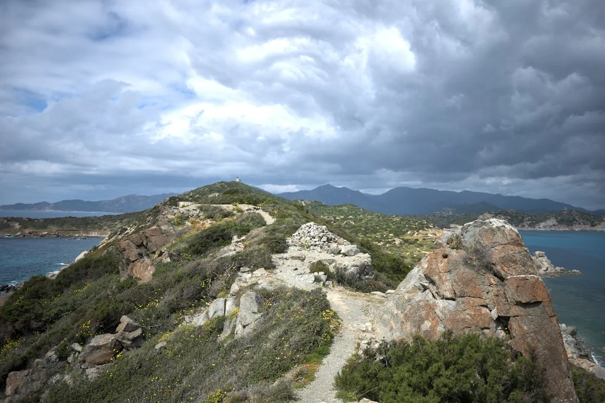
The Sardinia Coastal Trail is a masterclass in coastal diversity. Unlike many European coastal paths that follow well-trodden promenades, the Sardinian route is often raw, rocky, and remarkably isolated. The trail is characterised by its geological variety: the south-east is defined by smooth granite boulders and long sandy beaches; the east coast features the dramatic limestone cliffs of the Supramonte, where the mountains plunge vertically into the sea; the north is a labyrinth of wind-carved red granite; and the west coast offers the "Costa Verde," a stretch of towering sand dunes and abandoned 19th-century mines that feel like a film set from a bygone era.
Walking this trail requires a different mindset than alpine trekking. Here, the challenges are not just vertical gain, but the intensity of the Mediterranean sun, the scarcity of freshwater sources in certain limestone sectors, and the technical nature of the "capraie" (goat tracks) that often serve as the primary path. The trail is a sensory experience: the constant sound of the sea, the abrasive feel of volcanic rock, and the "Macchia Mediterranea"—a thick evergreen shrubland that provides a constant olfactory backdrop of juniper, mastic, and wild herbs. Because the trail passes through numerous protected marine areas and regional parks, walkers are treated to an ecosystem that remains largely intact, home to peregrine falcons, wild boars, and the rare Sardinian deer.
While the total distance of 400 kilometres can be daunting, the trail is naturally segmented by coastal towns and villages, allowing for a flexible approach. Some walkers choose to tackle the entire "Grand Tour" over a month, while others focus on specific regional sections. Regardless of the distance covered, the Sardinia Coastal Trail offers a rare sense of frontier exploration in the heart of modern Europe. It is a journey that connects the island's maritime heritage with its rugged interior traditions, providing a comprehensive portrait of an island that has always considered itself a "micro-continent."
History and Cultural Context
Sardinia’s coastline is a living museum, and the trail serves as its primary corridor. For millennia, the island’s shores were both a source of wealth and a point of extreme vulnerability. The trail frequently passes the "Torri Costiere"—a network of over 100 Spanish watchtowers built between the 16th and 17th centuries to defend the island against Barbary pirate raids. These stone sentinels, perched on every prominent headland, provide a hauntingly beautiful rhythm to the walk and serve as excellent navigational landmarks.
Deepening the historical layers are the remnants of the Nuragic civilisation, unique to Sardinia. While most Nuraghe (conical stone fortresses) are found inland, several significant sites overlook the sea, dating back to the Bronze Age (1800 BCE). These structures represent some of the oldest and most sophisticated dry-stone architecture in the world. In the western Iglesiente sector, the trail takes on an industrial historical character. Here, walkers traverse the "Cammino di Santa Barbara," passing through abandoned mining villages like Ingurtosu and Montevecchio. These sites, now UNESCO-recognised, tell the story of the 19th-century mining boom that once made Sardinia a global centre for lead and zinc production. The juxtaposition of these crumbling industrial ruins against the pristine "Green Coast" is one of the most evocative experiences on the trail.
Culturally, the trail bridges the gap between the "Sardi di Mare" (coastal people) and the "Sardi di Terra" (inland people). Historically, Sardinians retreated to the mountains to escape invaders and malaria, leaving the coast sparsely populated. This historical quirk is why so much of the coastline remains wild today. Walking the trail allows you to witness the modern revival of coastal culture, from the traditional fishing tonnare (tuna traps) of Carloforte to the sophisticated viticulture of the Gallura region, where Vermentino grapes thrive in the salty sea breeze.
Want more background? Read extended notes on history and cultural context → Learn more about Sardinian Heritage
Seasonal Highlights and Weather Reality
Timing is the most critical factor when planning the Sardinia Coastal Trail. The Mediterranean climate is unforgiving in mid-summer and can be surprisingly volatile in winter. The "Mistral" (Maestrale), a powerful north-westerly wind, is a defining feature of the Sardinian climate; it can blow for days, cooling the air but creating challenging conditions for walkers on exposed cliff tops.
Spring (April to June): This is arguably the "Golden Age" for the trail. The island is in full bloom, with the macchia producing a riot of yellow gorse and white cistus flowers. Temperatures are mild (18°C to 25°C), and the water sources are at their most reliable. The days are long enough for significant mileage, and the coastal towns are beginning to wake up from winter hibernation without the summer crowds.
Autumn (September to October): The sea remains warm enough for swimming well into October, making this the best season for those who want to combine hiking with daily dips in the Mediterranean. The intense heat of August has dissipated, though the landscape is much drier and more "burnt" than in spring. This is also the season of the grape harvest, adding a festive atmosphere to the villages along the route.
Winter (November to March): While snow is rare on the coast, winter brings heavy rains and fierce winds. Many seasonal hotels and campsites close, making logistics significantly more difficult. However, for the self-sufficient walker, the winter offers total solitude and a stark, dramatic beauty, with temperatures typically hovering between 10°C and 15°C.
Summer (July to August): Walking the full trail in summer is strongly discouraged. Temperatures regularly exceed 35°C, and the lack of shade on the coastal paths can lead to severe heatstroke. Furthermore, water scarcity becomes a genuine danger in the limestone regions of the east. If you must walk in summer, limit activity to the very early morning and late evening.
Recommended Itinerary
The Grand Sardinia Coastal Odyssey (30-Day Breakdown)
Segment 1: The South East (Cagliari to Arbatax) - 8 Days
- Distance: 110 km
- Key Waypoints: Cagliari, Villasimius, Costa Rei, Muravera, Tertenia, Arbatax
- Day 1-2: Depart Cagliari, traversing the "Golfo degli Angeli" towards the granite peaks of Villasimius.
- Day 3-5: Follow the long, white-sand stretches of Costa Rei, passing Spanish towers and lagoons filled with pink flamingos.
- Day 6-8: The terrain becomes more rugged as you enter the Ogliastra region, with steep climbs over coastal ridges leading into the port of Arbatax.
- Highlights: Capo Carbonara Marine Protected Area and the secluded coves of Cala Sa Figu.
Segment 2: The Wild East (Arbatax to Olbia) - 7 Days
- Distance: 90 km
- Key Waypoints: Santa Maria Navarrese, Cala Goloritzé, Cala Luna, Dorgali, Orosei, San Teodoro, Olbia
- Day 9-11: This is the most technical section, involving the famous "Selvaggio Blu" territory (though the coastal trail takes a slightly less technical inland/coastal hybrid route). Steep limestone cliffs and no road access.
- Day 12-14: Descend into the Gulf of Orosei. This requires careful planning for water and supplies.
- Day 15: A flatter finish through the wetlands and beaches of San Teodoro towards the bustling port of Olbia.
- Highlights: The limestone arch of Cala Goloritzé and the sea caves of Bue Marino.
Segment 3: The Granite North (Olbia to Alghero) - 8 Days
- Distance: 120 km
- Key Waypoints: Porto Cervo, Palau, Santa Teresa Gallura, Costa Paradiso, Castelsardo, Porto Torres, Alghero
- Day 16-18: Traverse the "Costa Smeralda." While developed, the coastal paths remain beautiful.
- Day 19-21: Enter the Gallura region. The red granite formations at Capo Testa are a geological marvel.
- Day 22-24: Follow the northern coast through the medieval fortress town of Castelsardo and across the Nurra plains towards the Catalan-influenced city of Alghero.
- Highlights: The "Moon Valley" (Valle della Luna) near Santa Teresa and the Neptune’s Grotto cliffs.
Segment 4: The Mining West (Alghero to Cagliari) - 7 Days
- Distance: 80 km (Focusing on the most scenic sections)
- Key Waypoints: Bosa, Torre del Pozzo, Costa Verde, Buggerru, Masua, Carloforte (San Pietro Island), Pula, Cagliari
- Day 25-26: The spectacular cliff path from Alghero to the colourful town of Bosa.
- Day 27-28: The "Costa Verde" (Green Coast). Massive sand dunes at Piscinas and the abandoned mines of Ingurtosu.
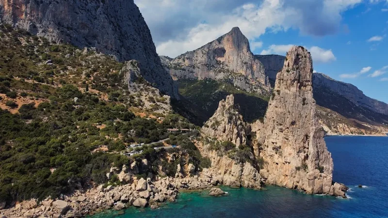
- Day 29-30: The dramatic "Pan di Zucchero" sea stack at Masua, followed by a final push through the Roman ruins of Nora back to Cagliari.
- Highlights: The Piscinas dunes (highest in Europe) and the mining tunnels of Porto Flavia.
Important Notes:
- The trail is not always a single, continuous marked path; it often requires connecting regional trails (like the Sentiero Italia or Cammino di Santa Barbara).
- Public transport (ARST buses) is excellent for skipping less scenic industrial sections or connecting segments.
- Water management is critical in the East (Ogliastra) and West (Costa Verde) sections.
- Wild camping is technically restricted; use established campsites or agriturismi where possible.
Planning and Bookings
Book Your Trip
Everything you need to plan your journey
Accommodation
Find places to stay near Cagliari
Flights
Search flights to Cagliari
Essential Preparation
The Sardinia Coastal Trail requires significant logistical foresight. Unlike the Camino de Santiago, there is no single "pilgrim office" or universal credential. You are essentially stitching together several regional routes. Fitness requirements are moderate, but the ability to walk 20 kilometres a day on uneven, rocky terrain in warm weather is essential. You should be comfortable with basic navigation using GPS and offline maps, as waymarking can be inconsistent in remote areas.
Cagliari is the most logical base for the southern and western sections, while Olbia serves the north and east. Both cities have international airports and major ferry terminals connecting to mainland Italy (Livorno, Civitavecchia, Genoa). It is highly recommended to spend two days in your arrival city to organise gas canisters, local SIM cards, and final supplies. Learning basic Italian phrases is highly beneficial, as English is less commonly spoken in the smaller coastal villages of the interior.
Trail Accommodation
Accommodation on the Sardinia Coastal Trail varies wildly depending on the segment. In the more developed North (Costa Smeralda) and South (Villasimius), you will find a plethora of hotels, B&Bs, and luxury resorts. In the wilder East and West, options are more limited.
Types of Accommodation:
- Agriturismi: Working farms that offer rooms and incredible traditional meals. These are the highlight of Sardinian hospitality. Booking is essential, especially in shoulder seasons.
- Campsites (Campeggi): Numerous along the coast, usually open from April to October. They offer showers, electricity, and often small supermarkets. Costs range from €15 to €30 per night.
- B&Bs and Guesthouses: Common in coastal towns like Bosa, Santa Teresa, and Orosei. Expect to pay €50–€90 per night.
- Rifugi (Mountain Huts): Very rare on the coast. The "Rifugio Goloritzé" is one of the few exceptions in the Ogliastra region.
What is NOT provided: Most accommodation does not cater specifically to long-distance hikers. Do not expect laundry facilities at every stop or "luggage transfer" services outside of the most popular tourist zones. Wild camping is officially prohibited in regional parks and on beaches, though it is often tolerated in remote areas if you arrive late, leave early, and follow strict Leave No Trace principles. However, during the fire-risk season (June–September), enforcement is very strict.
Required Gear
- Footwear: Sturdy trekking shoes or mid-cut boots with a high-grip sole (Vibram or similar). The rock is often sharp limestone or abrasive granite.
- Navigation: A dedicated GPS device or a smartphone with offline maps (Gaia GPS, Komoot, or AllTrails). A backup power bank (10,000mAh minimum) is mandatory.
- Sun Protection: A wide-brimmed hat, high-quality sunglasses (Category 3 or 4), and SPF 50+ sunscreen. The Mediterranean sun reflects intensely off the white limestone and water.
- Clothing: Lightweight, moisture-wicking fabrics. A light windbreaker is essential for the Mistral winds. Even in spring, a fleece is needed for cool evenings.
- Pack: A 35–50L backpack with a good ventilation system (suspended mesh back) to manage sweat in the heat.
- First Aid: Focus on blister care (Compeed), electrolyte salts (to prevent dehydration), and basic antiseptics for scratches from the thorny macchia.
What to Bring
- Water Treatment: A lightweight filter (Sawyer Squeeze) or purification tablets. While tap water in towns is safe, you may need to rely on rural wells or springs in the Ogliastra.
- Water Capacity: Ability to carry at least 3–4 litres of water. This is non-negotiable for the remote eastern sections.
- Food: Carry 2 days of emergency rations (couscous, nuts, dried fruit). While you pass through towns frequently, many shops close for "siesta" (1:00 PM to 5:00 PM).
- Cooking: A small multi-fuel or gas stove if you plan on camping. Note: Gas canisters (screw-top) are available in Cagliari, Olbia, and Alghero at outdoor stores like Decathlon.
- Personal Items: Biodegradable soap, a quick-dry travel towel, and a lightweight silk sleeping bag liner for B&Bs or agriturismi.
- Cash: Many small bars and rural agriturismi in Sardinia still prefer cash over card. Carry at least €100–€200 in small denominations.
Permits
For the vast majority of the Sardinia Coastal Trail, no formal permits or entry fees are required. The coastline is public land, and the trails are generally open access. However, as the trail gains popularity and environmental pressures increase, certain high-impact areas have introduced access controls.
Specific Access Requirements:
- Cala Goloritzé (Ogliastra): To protect this UNESCO site, access is limited to a set number of visitors per day. You must book your entry via the "Heart of Sardinia" app. The fee is approximately €6 per person.
- Asinara National Park (North-West): If you choose to detour to this island, you must arrive via authorised ferry and follow strict park regulations. No private vehicles are allowed.
- Regional Parks (e.g., Porto Conte): Some specific trails within regional parks may require a small "environmental contribution" fee, usually collected at visitor centres.
Camping Regulations: It is important to distinguish between "camping" (setting up a base for days) and "bivouacking" (sleeping for one night). While both are technically restricted on the coast, bivouacking in remote areas is generally overlooked if done discreetly. However, in the "Zone di Protezione Speciale" (ZPS), fines can be heavy. Always check for local signage, especially near beaches.
Other Activities in the Area
Sardinia offers a wealth of experiences that complement a long-distance walk. If your legs need a break, consider these options:
- Sailing the La Maddalena Archipelago: From Palau, take a day trip or charter a boat to these granite islands. The water here is often cited as the clearest in the Mediterranean.
- Deep-Water Soloing and Climbing: The limestone cliffs of Cala Gonone and Baunei are world-class climbing destinations. Many routes start directly from the sea.
- Archaeological Tours: Visit the "Tombs of the Giants" (Tombe dei Giganti) or the Su Nuraxi di Barumini (a UNESCO World Heritage site) to delve deeper into the island's prehistoric mysteries.
- Wine Tasting in Gallura: Visit a "Cantina" to sample Vermentino di Gallura, the only Sardinian wine with DOCG status.
- Diving and Snorkelling: The Marine Protected Area of Tavolara offers incredible underwater visibility and the chance to see groupers, barracudas, and ancient Roman wrecks.
- Culinary Workshops: Learn to make "Culurgiones" (Sardinian ravioli) or "Malloreddus" in a traditional mountain village.
Safety and Conditions
Heat and Hydration: The single greatest risk on the Sardinia Coastal Trail is hyperthermia and dehydration. In the limestone sectors of the east coast, there is virtually no surface water. You must carry more water than you think you need. Learn the signs of heat exhaustion: dizziness, excessive sweating, and nausea. If these occur, stop immediately in whatever shade you can find and rehydrate with electrolytes.
Terrain and Navigation: The trail often follows "sentieri per capre" (goat paths). These can be narrow, crumbly, and overgrown with thorny vegetation. Scratches are inevitable; long trousers or gaiters are recommended for overgrown sections. GPS is essential because waymarking (red and white stripes) can disappear for kilometres at a time, especially where the trail crosses private grazing land.
Fire Risk: Sardinia is extremely prone to wildfires in the summer and autumn. A discarded cigarette or an unextinguished campfire can cause catastrophic damage. Lighting fires is strictly prohibited and carries heavy prison sentences. If you see smoke, move towards the coast or a cleared road and call 1515 (Forestry Corps) or 112 (Emergency).
Wildlife: While there are no dangerous predators, wild boars (cinghiale) are common. They are generally shy but can be aggressive if they have young or feel cornered. Store your food securely at night to avoid attracting them to your campsite. Ticks are also present in the tall grass during spring; perform a daily check.
Emergency Contacts: 112 is the universal emergency number in Italy. For mountain and wilderness rescue, ask for "Soccorso Alpino." Ensure you have travel insurance that specifically covers "search and rescue" and "hiking at altitude" (even though this is a coastal trail, the terrain is often classified as mountainous).
Side Trips and Points of Interest
Gola Su Gorropu: Often called "Europe's Grand Canyon," this massive limestone gorge is located slightly inland from the Gulf of Orosei. A day-trip detour from the coastal trail allows you to scramble over giant white boulders between walls that rise 500 metres vertically. It is a spectacular geological contrast to the coastal scenery.
Tiscali Village: A hidden Nuragic settlement built inside a collapsed limestone cave on a mountain top. It is one of the most atmospheric archaeological sites in Italy, accessible only by a steep hike. It offers a glimpse into how ancient Sardinians lived in total seclusion from coastal invaders.
Porto Flavia: Located near Masua on the west coast, this is a masterpiece of mining engineering. A tunnel was carved through the cliffs to allow ore to be loaded directly onto ships. The "hanging" entrance overlooking the Pan di Zucchero sea stack is one of the most photographed spots in Sardinia.
The Island of San Pietro (Carloforte): A short ferry ride from the south-west coast takes you to this unique island where the inhabitants speak a Genoese dialect and maintain a distinct culture based on traditional tuna fishing. The "Tabarka" heritage here is a fascinating footnote in Mediterranean history.
Capo Testa: Located at the northernmost tip of the island, this peninsula is a surreal landscape of granite boulders eroded by the wind into fantastic shapes. It was a Roman quarry, and you can still see unfinished columns lying among the rocks. The views across the Strait of Bonifacio to Corsica are unparalleled.
Leave No Trace
Sardinia’s coastal ecosystem is under significant pressure from tourism and climate change. As a long-distance walker, you have a responsibility to minimise your impact on this fragile landscape. The "Macchia" takes years to recover from trampling, and the white sand of the beaches is a finite resource (it is actually illegal to remove sand or shells from Sardinian beaches, with heavy fines enforced at airports).
Core Principles for the Trail:
- Waste Management: Pack out every single piece of trash, including organic waste like orange peels or nut shells, which decompose slowly in the arid climate.
- Human Waste: Use public toilets in towns whenever possible. In remote areas, bury waste in a "cathole" at least 20 centimetres deep and 60 metres from any water source or trail. Pack out your toilet paper.
- Water Protection: Do not use soaps or detergents (even biodegradable ones) directly in springs or coastal lagoons. These are vital watering holes for local wildlife.
- Respect Heritage: Do not climb on Nuragic ruins or Spanish towers. These are ancient structures held together by gravity and are easily damaged.
- Flora and Fauna: Stay on established paths to avoid crushing rare endemic plants. Do not feed the wild animals, particularly the foxes and boars that have become habituated to humans in some areas.