
São Miguel Coastal Trail - A Volcanic Odyssey Through the Atlantic
The São Miguel Coastal Trail is an extraordinary multi-day journey that circumnavigates significant portions of the largest island in the Azores archipelago, Portugal. Stretching approximately 120 kilometres along the rugged basaltic coastline, this trail offers a profound immersion into a landscape defined by dramatic volcanic activity, lush emerald pastures, and the relentless power of the Atlantic Ocean. Often referred to as the "Hawaii of Europe," São Miguel provides a trekking experience that is both prehistoric in its raw natural beauty and deeply rooted in a unique Macaronesian culture. The route traverses high sea cliffs, descends into secluded black sand coves, winds through ancient "fajãs" (flat fertile land at the base of cliffs), and passes through whitewashed fishing villages where time seems to have slowed to the rhythm of the tides.
- Distance: 120.0 km (approximate total of linked coastal sectors)
- Duration: 5–7 days
- Elevation Gain: 3,000 m total cumulative gain
- Difficulty: Moderate (requires endurance for consecutive days and steep coastal ascents)
- Best Time: April to October (stable weather and blooming flora)
- Closest City: Ponta Delgada
- Trailhead Access: Ponta Delgada (PDL) Airport; local buses and taxis provide access to various sector starts
- Direction: Generally clockwise or counter-clockwise; most walkers choose to link southern and eastern sectors
Overview
The São Miguel Coastal Trail is not a single, monolithic path but a masterfully curated sequence of official "PR" (Pequena Rota) and "GR" (Grande Rota) trails that, when linked, form a comprehensive coastal odyssey. The experience is defined by its geological diversity. One moment you are walking atop 200-metre-high cliffs of dark volcanic tuff, and the next you are descending stone-cut stairways into lush, humid ravines where endemic ferns and laurel trees create a prehistoric canopy. The trail serves as a living museum of volcanic history, showcasing basaltic columns, sea caves, and the famous "caldeiras" (volcanic craters) that have shaped the island's identity over millions of years.
Unlike many continental European trails, the São Miguel Coastal Trail is characterised by its intense verticality. While the total elevation gain of 3,000 metres might seem manageable over six days, the gain is often achieved through "sawtooth" profiles—constant short, steep climbs and descents as the path navigates the island's corrugated coastline. This physical challenge is rewarded by the sensory experience of the Azores: the scent of wild ginger (Conteira) and eucalyptus, the sight of the endemic Azores Bullfinch (Priolo) in the eastern forests, and the constant, rhythmic roar of the Atlantic swells crashing against the black rocks below.
The trail also offers a unique cultural perspective. Walkers pass through traditional vineyards protected by "currais" (small walls of volcanic stone), see the historic whale lookout towers (vigias) once used by whalers and now used by conservationists, and finish days in thermal hot springs that bubble up from the earth's crust. It is a journey that balances the wild isolation of the Atlantic with the warm hospitality of Azorean villages, making it one of the most diverse multi-day walks in the Northern Hemisphere.
History and Cultural Context
The history of the São Miguel Coastal Trail is inextricably linked to the settlement and survival of the Azorean people. When Portuguese explorers first arrived in the 15th century, the island was a dense, uninhabited wilderness of laurel forests. The early settlers carved paths along the coast to connect the fledgling villages, as the interior was often impassable due to dense vegetation and steep volcanic craters. These coastal paths became the lifelines of the island, used for transporting oranges (the "Golden Age" of Azorean trade), moving cattle to high summer pastures, and carrying fish from the coves to the village markets.
Culturally, the trail passes through areas of immense historical significance. In the south, walkers encounter the remnants of the 16th-century fortifications built to defend against corsairs and pirates. In the east, the trail traverses the Nordeste region, once known as the "tenth island" because it was so isolated from Ponta Delgada that it developed its own distinct traditions and dialects. The stone-paved sections of the trail, known as "caminhos reais" (royal roads), are testament to the incredible masonry skills of the islanders, who used local basalt to create durable paths that have survived centuries of seismic activity and Atlantic storms.
The trail also pays homage to the island's whaling history. Until the mid-20th century, whaling was a primary industry. The coastal paths were used by "vigias" (lookouts) who would signal the presence of whales to the boats below. Today, these lookout points serve as spectacular rest stops for hikers, offering panoramic views of the ocean where whales and dolphins are still frequently spotted—though now protected by strict conservation laws. Walking this trail is not just a physical exercise; it is a walk through the resilient history of a people who learned to thrive on the edge of the world.
Want more background? Read extended notes on history and cultural context → Learn more
Seasonal Highlights and Weather Reality
The Azores are famous for experiencing "four seasons in one day." Due to their position in the middle of the Atlantic, weather systems move quickly, and the island's high peaks create numerous microclimates. Understanding the seasonal nuances is essential for a successful trek on the São Miguel Coastal Trail.
Spring (April to June): This is arguably the most beautiful time to walk. The island is in full bloom, with hydrangeas (the island's floral symbol) beginning to line the paths in late June. The temperatures are mild (15–20°C), and the waterfalls are at their most powerful. However, spring can still bring "Azorean mist," a fine, persistent drizzle that can obscure coastal views.
Summer (July to August): The most stable weather period, with temperatures averaging 22–26°C. The sea is at its calmest and warmest, making the black sand beach stops along the trail particularly inviting. This is the peak season for whale watching. The downside is that the trail can be more crowded, and accommodation in smaller villages must be booked months in advance.
Autumn (September to October): A fantastic time for trekking. The sea remains warm enough for swimming, and the summer crowds have dispersed. The light in autumn is particularly soft, making it a favourite for photographers. The risk of Atlantic storms begins to increase in late October, so hikers should be prepared for wind and rain.
Winter (November to March): While the Azores never get truly cold (temperatures rarely drop below 10°C at sea level), winter is the wettest season. High winds can make coastal cliff sections dangerous, and low clouds often shroud the viewpoints. Many guesthouses in smaller villages may close for the season. Only experienced hikers comfortable with wet-weather gear and navigation should attempt the full trail in winter.
Recommended Itinerary
6-Day São Miguel Coastal Odyssey
Day 1: Ponta Delgada to Lagoa
- Distance: 14 km
- Elevation gain: 150 m
- Time: 4 hours
- Start at the Portas da Cidade in Ponta Delgada
- Follow the coastal promenade (Avenida) eastward
- Pass the volcanic beaches of Pópulo and Milícias
- Explore the traditional pottery workshops in Lagoa
- Key Waypoints: Forte de São Brás, Rocha da Relva (optional detour), São Roque Church
- An easy introductory day allowing for a late start or morning exploration of the capital
Day 2: Lagoa to Vila Franca do Campo
- Distance: 19 km
- Elevation gain: 400 m
- Time: 5–6 hours
- Walk through the historic centre of Lagoa before hitting coastal tracks
- Pass through the Caloura protected area, famous for its microclimate and vineyards
- Descend to the picturesque harbour of Porto da Caloura for a swim
- Arrive in Vila Franca do Campo, the island's first capital
- Key Waypoints: Caloura Convent, Baixa da Areia beach, Ermida de Nossa Senhora da Paz (steep climb above the town)
Day 3: Vila Franca do Campo to Furnas (Coastal/Inland Link)
- Distance: 22 km
- Elevation gain: 700 m
- Time: 7–8 hours
- Follow the coast to Ribeira Quente via a dramatic forest trail
- Pass through the "Agua Retorta" forest sections
- Ascend from the coast into the volcanic valley of Furnas
- Key Waypoints: Ribeira Quente waterfall, Lagoa das Furnas, Caldeiras (boiling mud pools)
- This day transitions from the salt spray of the coast to the geothermal heart of the island
Day 4: Furnas to Povoação
- Distance: 16 km
- Elevation gain: 500 m
- Time: 5 hours
- Exit the Furnas valley through ancient laurel forests
- Descend toward the coast at Povoação, the site of the first settlement on the island
- Walk along the "Lomba do Cavaleiro" for panoramic views of the eastern cliffs
- Key Waypoints: Pico do Ferro lookout, Ribeira do Guilherme, Povoação historic centre
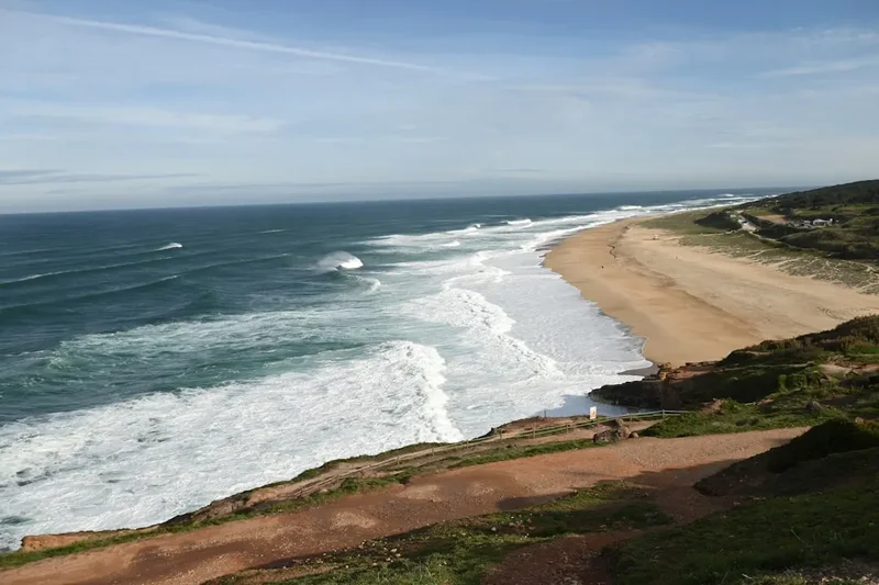
Day 5: Povoação to Nordeste
- Distance: 25 km
- Elevation gain: 900 m
- Time: 8–9 hours
- The most challenging and spectacular day of the trek
- Traverse the high sea cliffs of the eastern coast
- Pass through the "Parque Natural do Alnel"
- Key Waypoints: Ponta do Sossego viewpoint, Ponta da Madrugada, Farol do Arnel (steepest road in the Azores)
- Arrive in Nordeste, the most isolated and floral town on the island
Day 6: Nordeste to Ribeira Grande (North Coast Finish)
- Distance: 24 km
- Elevation gain: 350 m
- Time: 7 hours
- Follow the rugged north coast, known for its surf and tea plantations
- Pass through the Gorreana and Porto Formoso tea estates (the only ones in Europe)
- Finish in the surfing mecca of Ribeira Grande
- Key Waypoints: Gorreana Tea Factory, Praia dos Moinhos, Santa Iria lookout
Important Notes:
- The trail uses a mix of PR (Short Route) and GR (Great Route) markings; carry a GPS or detailed map
- Public transport (Varela buses) is available but infrequent; plan your finish times carefully
- Coastal erosion can occasionally close small sections; always check local "Trilhos" updates
- Water is generally safe to drink from village fountains, but treatment is recommended for stream water
- The "sawtooth" nature of the cliffs means 20km in the Azores feels like 30km on flat ground
Planning and Bookings
Book Your Trip
Everything you need to plan your journey
Accommodation
Find places to stay near Ponta Delgada
Flights
Search flights to Ponta Delgada
Essential Preparation
The São Miguel Coastal Trail requires a moderate level of physical fitness. While the technical difficulty is low, the cumulative fatigue of multiple 20-kilometre days with significant elevation changes should not be underestimated. Walkers should be comfortable with steep, sometimes slippery descents on volcanic soil. Preparation should include hill walking with a weighted pack in the weeks leading up to the trip.
Logistically, the trail is best organised by basing yourself in Ponta Delgada for the first and last nights. The island's bus system (Varela and Auto Viação Micaelense) connects most major towns, but schedules are designed for locals, not tourists, meaning early morning departures are common. Taxis and ride-sharing apps are available but can be expensive for long distances. Booking accommodation in smaller villages like Povoação and Nordeste is critical, as options are limited and often fill up with European hikers during the summer months.
Trail Accommodation
Accommodation on the São Miguel Coastal Trail is varied, ranging from boutique guesthouses to traditional "Turismo Rural" (rural tourism) cottages. There are no mountain huts in the traditional Alpine sense; instead, you will stay in the villages that the trail passes through.
Types of Accommodation:
- Hostels and Guesthouses: Available in Ponta Delgada, Vila Franca, and Ribeira Grande. Expect to pay €30–€60 per night for a private room.
- Turismo Rural: Beautifully restored stone houses in Nordeste and Povoação. These offer a high level of comfort and local character, usually costing €80–€120 per night.
- Campsites: Official campsites exist in Sete Cidades, Furnas, and Nordeste. Facilities are basic (toilets, cold showers). Wild camping is officially prohibited in the Azores to protect the fragile volcanic ecosystem.
- Local Pensions (Pensões): Small, family-run inns found in almost every village. They are often not listed on major booking sites; look for "Quartos" signs.
Facilities Provided: Most guesthouses provide linens, towels, and WiFi. Breakfast is usually included or available for a small fee. In smaller villages, your host may offer to cook a traditional dinner (often featuring local fish or "Cozido") if requested in advance.
Required Gear
- Footwear: Sturdy, waterproof hiking boots with deep lugs. The volcanic soil can be incredibly slippery when wet, and basalt rocks are sharp.
- Rain Gear: A high-quality, breathable waterproof jacket (minimum 15,000mm rating). The Azores are humid; cheap plastic ponchos will cause excessive sweating.
- Backpack: A 35–45L pack is sufficient if staying in guesthouses. Ensure it has a high-quality rain cover.
- Clothing: Moisture-wicking base layers (merino wool is ideal for managing humidity), a lightweight fleece or "puffy" jacket for evenings, and quick-dry trekking trousers.
- Navigation: A dedicated GPS device or a smartphone with offline maps (e.g., AllTrails or Komoot). Trail markings can be inconsistent in forest sections.
- Sun Protection: SPF 50+ sunscreen, a wide-brimmed hat, and polarised sunglasses. The Atlantic sun is deceptively strong even on overcast days.
What to Bring
- Water Treatment: While tap water in towns is excellent, a filtered water bottle (like a LifeStraw or Sawyer Squeeze) is useful for refilling from mountain springs.
- Snacks: High-energy bars, nuts, and local dried fruit. Most villages have "Mercearias" (small grocery stores) where you can buy local cheese (Queijo da Ilha) and bread for lunches.
- First Aid: Blister plasters (Compeed), antiseptic cream, antihistamines (for plant stings), and any personal medications.
- Power Bank: Essential for keeping your navigation device charged, as cold/damp conditions can drain batteries faster.
- Trekking Poles: Highly recommended for the steep coastal descents to save your knees.
- Swimwear: Essential for the thermal baths in Furnas and the ocean swimming spots in Caloura and Ribeira Quente.
Permits
One of the greatest advantages of hiking in the Azores is that no official permits or fees are required to walk the São Miguel Coastal Trail. The trails are part of the Regional Network of Trails of the Azores and are free for public use. However, there are specific regulations and "indirect" costs that walkers must be aware of to ensure a smooth journey.
Access and Regulations:
- No Permit Required: You do not need to register with any authority to start your walk.
- Group Limits: While there are no hard limits on group sizes, the narrow nature of coastal paths and the limited capacity of village guesthouses make groups of 2–4 ideal.
- Protected Areas: Large sections of the trail pass through Natural Parks (Parque Natural de Ilha). In these areas, you must stay strictly on the marked paths to protect endemic species like the Azores Bullfinch.
- Thermal Bath Fees: While the trail is free, the highlights along the way are not. Entry to the Terra Nostra Garden or Poça da Dona Beija in Furnas costs approximately €8–€10.
- Whale Watching: If you choose to take a boat trip during a rest day, expect to pay €50–€65 per person.
Booking Strategy: Because no permit is required, the "bottleneck" for this trail is accommodation. For the peak months of July and August, you should book your guesthouses at least 4–6 months in advance. If you are flexible and walking in the shoulder seasons (May or September), 1–2 months is usually sufficient. Always have a digital or printed copy of your accommodation bookings, as mobile signal can be spotty in the deep ravines of the Nordeste region.
Other Activities in the Area
São Miguel is a playground for outdoor enthusiasts. If you have extra days, consider these world-class experiences:
- Sete Cidades Kayaking: Paddle the twin lakes (one green, one blue) inside a massive volcanic caldera. The perspective from the water, looking up at the 300-metre crater walls, is unforgettable.
- Canyoning in Nordeste: The island's steep ravines and abundant waterfalls make it one of the best canyoning destinations in the Atlantic. Tours range from beginner-friendly slides to 30-metre technical abseils.
- Terra Nostra Thermal Baths: Located in Furnas, this 18th-century botanical garden features a massive iron-rich thermal pool (38°C). It is the ultimate recovery tool for tired hiker legs.
- Whale and Dolphin Watching: Depart from Ponta Delgada or Vila Franca do Campo. The Azores are a permanent home or migratory stop for over 20 species of cetaceans, including Blue Whales and Sperm Whales.
- Gorreana Tea Plantation: Visit the oldest tea plantation in Europe. You can walk through the tea hedges and see the original 19th-century British machinery still in use.
- Lagoa do Fogo: Hike to the "Lake of Fire," a pristine crater lake surrounded by high peaks and endemic vegetation. It is often cited as the most beautiful spot on the island.
Safety and Conditions
Coastal Hazards: The primary safety concern on the São Miguel Coastal Trail is the stability of the cliffs. The island is geologically young and composed of loose volcanic tuff and basalt. Heavy rain can lead to localized landslides or "desabamentos." Never cross a path that appears to have collapsed, and avoid standing near the very edge of cliffs, especially in high winds. If a section of the trail is marked with "Passagem Proibida," respect it—these closures are usually due to genuine structural danger.
Weather and Exposure: The Azores are subject to rapid changes in visibility. "O nevoeiro" (the fog) can roll in from the Atlantic in minutes, reducing visibility to less than 10 metres. If you lose the trail in the fog, stay put or backtrack to the last known marker. Hypothermia is a risk even in summer if you get wet and the wind picks up; always carry your waterproof shell in your daypack, regardless of how blue the sky looks in the morning.
Emergency Services: The universal emergency number in Portugal is 112. Most trail markers include a small number or coordinate; if you need to call for help, try to provide the name of the PR/GR trail you are on and the last landmark you passed. Note that in the deep valleys of the north and east coasts, mobile signal can be non-existent. It is highly recommended to hike with a partner or inform your guesthouse of your intended route and estimated arrival time.
Flora and Fauna: There are no snakes or dangerous predatory mammals in the Azores. The main biological hazard is the Portuguese Man o' War (Caravela Portuguesa), which can occasionally wash up on beaches. Do not touch them, even if they appear dead, as their sting is extremely painful. Some plants, like the invasive Wild Ginger, can have sharp leaves that cause minor cuts; long trousers are recommended for overgrown sections.
Side Trips and Points of Interest
Ermida de Nossa Senhora da Paz: Located high above Vila Franca do Campo, this 18th-century chapel is reached via a striking staircase with tiled (azulejo) landings depicting the stations of the cross. The view from the top encompasses the entire southern coast and the iconic Islet of Vila Franca. It is a steep 2km detour from the main trail but offers the best photographic perspective of the town.
Ribeira Quente and the "Hidden" Waterfall: On the descent from Furnas to the coast, a small, unmarked path leads to a spectacular waterfall hidden behind a tunnel of vegetation. The water falls into a natural stone basin, providing a refreshing (if cold) swimming spot. Ask locals in Furnas for the "Cascata da Ribeira Quente" directions.
Farol do Arnel: Located at the easternmost tip of the island near Nordeste, this is the oldest lighthouse in the Azores (1876). The road leading down to it is famous for being the steepest in the archipelago (35% gradient). While the walk down is easy, the walk back up is a legendary test of fitness for any hiker.
The Tea Route: Between Maia and Porto Formoso on the north coast, the trail passes directly through the tea fields. This is a unique agricultural landscape where the rows of Camellia sinensis follow the contours of the hills, creating a manicured green tapestry that contrasts sharply with the wild Atlantic waves just metres away.
Rocha da Relva: A small detour near Ponta Delgada takes you down a steep cliff path to a "fajã" where locals still use donkeys to transport goods. It is a micro-community of small vineyards and summer houses that feels completely disconnected from the modern world.
Leave No Trace
The Azores are a fragile volcanic ecosystem with a high percentage of endemic species found nowhere else on Earth. As a walker, you are a guest in a landscape that is under constant pressure from invasive species and increasing tourism. Following Leave No Trace principles is not just a suggestion; it is vital for the survival of the island's natural heritage.
Azorean LNT Guidelines:
- Stay on the Path: Volcanic soil is highly susceptible to erosion. Taking shortcuts on switchbacks creates "social trails" that turn into gullies during heavy rain, destroying the path for everyone.
- Protect the Water: Many of the island's streams provide drinking water for the villages below. Never wash yourself or your gear directly in a stream; carry water 30 metres away and use biodegradable soap.
- Invasive Species Awareness: Clean your boots thoroughly before starting the trail and between different islands. Seeds from invasive plants (like Himalayan Ginger) are easily transported in boot treads and can outcompete the native laurel forest.
- Respect the "Currais": The stone walls protecting vineyards are historic structures. Do not climb on them or remove stones; they are often held together only by gravity and careful placement.
- Waste Management: There are no bins on the trails. Pack out every piece of litter, including organic waste like orange peels or banana skins, which decompose slowly in the acidic volcanic soil and can attract non-native rodents.
- Quiet Observation: If you are lucky enough to see the Azores Bullfinch in the Nordeste forests, keep your distance and remain quiet. They are one of Europe's rarest birds and are easily stressed by human presence.