
Santa Cruz Trek - The Jewel of the Cordillera Blanca
The Santa Cruz Trek is widely considered the most spectacular high-altitude circuit in the Peruvian Andes, offering an unparalleled journey through the heart of the Cordillera Blanca. Spanning approximately 50 kilometres over four days, this trek traverses the Huascarán National Park, a UNESCO World Heritage site renowned for its staggering density of 6,000-metre peaks, turquoise glacial lagoons, and unique high-altitude ecosystems. Unlike many other Andean routes that focus on archaeological ruins, the Santa Cruz Trek is a celebration of raw, vertical geography. It takes walkers through deep, glaciated valleys, over the formidable Punta Union pass at 4,750 metres, and beneath the shadows of iconic mountains like Alpamayo—once voted the most beautiful mountain in the world—and the massive Taulliraju. This is a journey that demands physical resilience and proper acclimatisation, but rewards the effort with some of the most dramatic mountain scenery on the planet.
- Distance: 50.0 km one-way
- Duration: 4 days / 3 nights
- Season: May to September (dry season/Andean summer)
- Accommodation: Designated wilderness campsites (no huts or lodges)
- Highest point: Punta Union Pass (4,750 m)
- Difficulty: Moderate to challenging (primarily due to altitude)
- Direction: Typically walked from Cashapampa to Vaqueria (or reverse)
- Closest City: Huaraz, Peru (3,050 m)
Overview
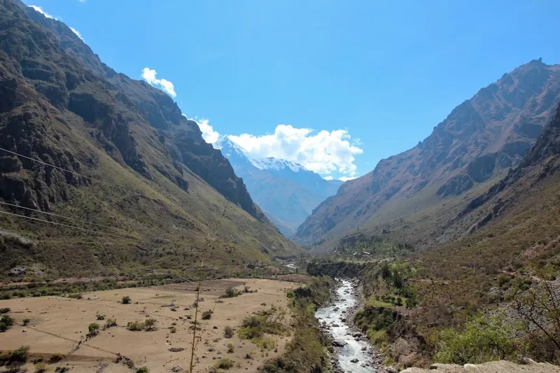
The Santa Cruz Trek is the quintessential Andean experience, distilled into a four-day odyssey. Located in the Ancash region of northern Peru, the route carves a path through the Cordillera Blanca, the highest tropical mountain range in the world. The trek is defined by its extreme verticality; walkers move from the semi-arid, cactus-dotted lower valleys at 2,900 metres to the thin, frigid air of alpine passes nearly five kilometres above sea level. The landscape is a masterclass in glacial geology, featuring classic U-shaped valleys, hanging glaciers that groan and crack in the midday sun, and moraine-dammed lakes of such intense turquoise they appear artificial.
What sets the Santa Cruz apart from other famous Peruvian treks, such as the Inca Trail, is the sheer scale of the surrounding peaks. Throughout the journey, you are flanked by giants: Huascarán (6,768 m), Huandoy (6,395 m), and the jagged granite spires of the Santa Cruz massif itself. The route is not merely a path between points but a transition through distinct ecological zones. You begin in the Quechua zone, where small-scale agriculture and hardy shrubs dominate, before ascending into the Puna—a high-altitude grassland characterised by ichu grass and the rare, twisted Polylepis trees (locally known as Quenual), which are among the highest-growing trees in the world.
The trek is typically organised as a four-day expedition starting from the village of Cashapampa and ending in Vaqueria. This direction is often preferred as it allows for a more gradual ascent through the Santa Cruz Valley, aiding in the vital process of acclimatisation before tackling the high pass on Day 3. While the path is well-trodden and relatively easy to follow, the environment is unforgiving. Weather in the Andes is notoriously fickle; even in the dry season, a clear morning can transform into a snow-dusted afternoon within an hour. The physical challenge is significant—not necessarily due to technical terrain, but because of the sustained effort required to hike at altitudes where oxygen levels are roughly 50% lower than at sea level. For those who have spent time preparing in Huaraz, the Santa Cruz Trek offers a profound sense of isolation and a front-row seat to the majesty of the high Andes.
History and Cultural Context
The history of the Santa Cruz Trek is inextricably linked to the Huascarán National Park, established in 1975 to protect the unique biodiversity and geological heritage of the Cordillera Blanca. However, the human history of these valleys stretches back millennia. Long before modern mountaineers arrived, the valleys were used by the Chavín and later the Recuay and Inca cultures as high-altitude transit routes for trade and religious pilgrimage. The "Punta Union" pass itself served as a vital link between the lush eastern slopes of the Andes and the drier western valleys, allowing for the exchange of coca leaves, salt, and textiles.
In the early 20th century, the Cordillera Blanca became a magnet for European explorers and scientists. The region gained international fame in the 1930s and 40s during the German-Austrian expeditions, which mapped much of the range and completed many first ascents. The Santa Cruz Valley became a primary access point for climbers targeting Alpamayo and Artesonraju (the mountain famously rumoured to be the inspiration for the Paramount Pictures logo). The trek as it exists today was formalised as tourism in Huaraz grew in the 1980s, becoming the "classic" route for those wanting to experience the range without requiring technical climbing skills.
Culturally, the area remains home to Quechua-speaking communities who continue to graze livestock—primarily cattle and sheep—in the high valleys. You will often encounter local "arrieros" (donkey drivers) who facilitate the trek by transporting gear for groups. Their deep knowledge of the terrain and weather patterns is a living link to the ancestral relationship between the Andean people and these formidable mountains. The land is not just a park; it is a sacred landscape where peaks are often regarded as "Apus" or mountain spirits in traditional Andean cosmology.
Want more background? Read extended notes on history and cultural context → Learn more
Seasonal Highlights and Weather Reality
The Santa Cruz Trek is governed by the distinct wet and dry seasons of the Peruvian Andes. Understanding these cycles is crucial for safety and enjoyment, as the high-altitude environment leaves little room for error.
The Dry Season (May to September): Known as the "Andean Summer," this is the peak trekking window. During these months, the weather is characterised by stable high-pressure systems, resulting in clear blue skies and brilliant sunshine during the day. Visibility is at its best, offering the iconic views of Alpamayo and Taulliraju that make the trek famous. However, the clear skies mean that heat escapes rapidly at night; temperatures at the higher campsites like Taullipampa frequently drop to -5°C or even -10°C. Frost is a daily occurrence, and walkers must be prepared for extreme temperature fluctuations.
The Shoulder Seasons (April and October): These months can be rewarding but unpredictable. April often sees the landscape at its greenest following the rains, with wildflowers in bloom across the Puna. However, the risk of afternoon thunderstorms and heavy fog is significantly higher than in June or July. October marks the transition back to the rainy season, often bringing increased cloud cover that can obscure the high peaks for days at a time.
The Rainy Season (November to March): Trekking during this period is generally discouraged for all but the most experienced and well-equipped. Heavy rainfall makes the trails muddy and slippery, and the risk of landslides or rockfalls increases. At higher elevations, rain frequently turns to heavy snow, making the crossing of Punta Union dangerous due to poor visibility and hidden hazards. Many trekking agencies cease operations during these months, and the lack of views often defeats the purpose of the journey.
Regardless of the season, mountain weather can change in minutes. A "whiteout" on the pass is possible even in July. Proper layering and high-quality waterproof gear are non-negotiable requirements for any Santa Cruz expedition.
Recommended Itinerary
4-Day Santa Cruz Trek Itinerary (Cashapampa to Vaqueria)
Day 1: Cashapampa to Llamacorral
- Distance: 12 km
- Elevation gain: 860 m
- Time: 4–5 hours
- Depart Huaraz early for a 3-hour drive to Cashapampa (2,900 m)
- Register at the Huascarán National Park entrance
- Steady ascent through a narrow canyon alongside the Santa Cruz River
- Observe the transition from semi-arid vegetation to lush Andean forest
- Arrive at Llamacorral campsite (3,760 m)
- The first day is a steady climb designed to test your acclimatisation
- Evening views of the surrounding granite walls as the valley begins to open up
Day 2: Llamacorral to Taullipampa
- Distance: 14 km
- Elevation gain: 490 m
- Time: 5–6 hours
- Relatively flat walking through the wide, glaciated Santa Cruz Valley
- Pass the turquoise waters of Laguna Ichiccocha and Laguna Jatuncocha
- Optional side trip to the Alpamayo Base Camp and Arhuaycocha Lagoon (adds 2-3 hours)
- Spectacular views of Alpamayo (5,947 m) and Quitaraju (6,040 m)
- Arrive at Taullipampa campsite (4,250 m) situated at the base of Taulliraju
- This is arguably the most scenic campsite, surrounded by towering 5,000m and 6,000m peaks
Day 3: Taullipampa to Paria via Punta Union
- Distance: 14 km
- Elevation: 500 m gain to pass, 900 m descent
- Time: 7–8 hours
- The most challenging day of the trek, involving the crossing of Punta Union
- Steep, switchbacking ascent on an ancient stone path to the pass (4,750 m)
- Panoramic views of the Santa Cruz Valley behind and the Huaripampa Valley ahead
- Close-up views of the massive glaciers of Taulliraju (5,830 m)
- Long descent past alpine lakes (Laguna Taullicocha) into the lush Huaripampa Valley
- Pass through forests of Quenual trees (Polylepis)
- Arrive at Paria campsite (3,850 m)
Day 4: Paria to Vaqueria
- Distance: 10 km
- Elevation: 150 m descent (with some minor ups)
- Time: 3–4 hours
- Gentle descent through the Huaripampa Valley
- Pass through traditional Quechua villages and farming communities
- Observe local life, including traditional adobe houses and livestock grazing
- Final short climb to the road-head at Vaqueria (3,700 m)
- Meet transport for the spectacular drive back to Huaraz via the Portachuelo de Llanganuco pass (4,767 m)
- The drive back offers some of the best views of Huascarán and Huandoy
Important Notes:
- Acclimatisation is mandatory: Spend at least 2–3 days in Huaraz (3,050 m) before starting
- The route can be done in reverse, but the climb to Punta Union from Vaqueria is steeper
- Mules (donkeys) are the standard method for carrying heavy gear; arrange these in Huaraz or Cashapampa
- Water must be treated; despite the pristine appearance, livestock graze throughout the valleys
- Campsites are basic: No showers, limited pit toilets, and no electricity
- Pack for extreme cold; even in the "summer," night temperatures are freezing
Planning and Bookings
Book Your Trip
Everything you need to plan your journey
Accommodation
Find places to stay near Huaraz
Flights
Search flights to Huaraz
Essential Preparation
The Santa Cruz Trek is a high-altitude undertaking that requires serious physical and logistical preparation. The most critical factor is acclimatisation. Huaraz (3,050 m) serves as the primary base for the trek, and it is essential to spend a minimum of two to three days here before setting out. Most trekkers undertake "acclimatisation hikes" to Laguna Churup or Laguna 69 to prepare their bodies for the 4,750-metre pass. Attempting the trek without this preparation significantly increases the risk of Acute Mountain Sickness (AMS).
Logistically, you must decide between an organised tour or an independent trek. Organised tours are plentiful in Huaraz and typically include transport, a guide, a cook, and donkeys to carry gear. If trekking independently, you must arrange your own transport to Cashapampa and from Vaqueria, and you should be experienced in high-altitude navigation and self-sufficiency. Fitness requirements are moderate; you should be capable of walking 6–8 hours a day with a pack on varied terrain. Strengthening your cardiovascular system and lower body in the months leading up to the trip is highly recommended.
Trail Accommodation
There are no huts, lodges, or permanent shelters on the Santa Cruz Trek. This is a pure camping expedition. All trekkers must carry or arrange for tents, sleeping mats, and high-quality sleeping bags.
Campsite Facilities:
- Designated flat areas for pitching tents (Llamacorral, Taullipampa, Paria)
- Basic pit toilets are available at most major campsites, though their condition varies
- Natural water sources (rivers and streams) are nearby, but water MUST be treated
- No electricity, WiFi, or mobile signal anywhere on the trail
- No rubbish disposal; all waste must be carried out
What is NOT Provided:
- Shelter of any kind (you must bring your own tent)
- Bedding or mattresses
- Cooking facilities or fuel
- Food or snacks
- Medical facilities
Booking and Costs:
- No advance booking is required for the campsites themselves
- The primary cost is the Huascarán National Park entrance fee (see Permits section)
- If using a trekking agency, costs typically range from US$250 to US$500 for a 4-day all-inclusive service
- Independent trekkers should budget for transport (colectivos or private taxis) and donkey hire if needed (approx. S/ 40 per day per donkey, plus the arriero's fee)
Required Gear
- 4-season tent - Must be capable of withstanding high winds and potential snow
- Sleeping bag - Rated to at least -10°C (comfort rating, not extreme)
- Insulated sleeping mat - Crucial for blocking the cold from the frozen ground
- Trekking boots - Waterproof, well broken-in, with excellent ankle support
- Backpack - 50-70L if independent; 20-30L daypack if using donkeys
- Waterproof jacket and trousers - High-quality hardshell (Gore-Tex or similar)
- Down jacket - Essential for the freezing evenings and mornings at camp
- Trekking poles - Highly recommended for the steep descent from Punta Union
- Head torch - With extra batteries (nights are long and dark)
- Personal First Aid Kit - Including blister care and altitude medication (Acetazolamide/Diamox)
What to Bring
- Water treatment - UV purifier (SteriPEN), filter (Sawyer Squeeze), or chlorine dioxide tablets
- High-calorie food - If independent, focus on lightweight, nutrient-dense meals (dehydrated meals, nuts, chocolate)
- Sun protection - SPF 50+ sunscreen, lip balm with SPF, polarised sunglasses, and a wide-brimmed hat (the Andean sun is exceptionally strong)
- Warm layers - Merino wool base layers, fleece mid-layer, warm beanie, and insulated gloves
- Toiletries - Biodegradable soap, wet wipes, hand sanitiser, and plenty of toilet paper
- Power bank - To keep camera and phone (for photos/maps) charged
- Cash - Peruvian Soles (S/) for the park entrance fee, tips for guides/arrieros, and small purchases in villages
- Emergency whistle and mirror - Standard safety items for remote trekking
Permits
The Santa Cruz Trek takes place entirely within the Huascarán National Park. All visitors are required to purchase a park entrance permit. Unlike the Inca Trail, there is no daily limit on the number of trekkers, and permits do not need to be booked months in advance. However, you must ensure you have the correct ticket before starting.
Permit Types and Costs:
- Multi-day Ticket (up to 30 days): S/ 150 (approximately US$40). This is the standard ticket for the Santa Cruz Trek and other multi-day circuits like the Huayhuash.
- Short Stay Ticket (2-3 days): S/ 60. Generally not sufficient for the 4-day Santa Cruz Trek.
- Day Ticket: S/ 30. Only for single-day visits to spots like Laguna 69.
Where to Purchase:
- The National Park office in Huaraz (located near the main plaza)
- At the park entrance control points in Cashapampa or Vaqueria
- Many trekking agencies will include the permit in their package price, but always verify this
Important Regulations:
- You must carry your permit with you at all times; rangers may check it at various points along the trail
- The permit is non-transferable
- Registration of your passport details is required at the trailhead for safety and statistical purposes
- Failure to produce a valid permit can result in fines or being escorted from the park
Other Activities in the Area
Huaraz is the "Outdoor Capital of Peru," and there are numerous ways to extend your adventure before or after the Santa Cruz Trek:
- Laguna 69: A challenging day hike to a brilliant turquoise lake at 4,600 m. It is the most popular acclimatisation hike in the region.
- Laguna Churup: A shorter but steep hike from Huaraz to a beautiful alpine lake, featuring a fun section of scrambling with fixed cables.
- Pastoruri Glacier: One of the few glaciers in the tropical Andes that is easily accessible. It offers a sobering look at the effects of climate change at 5,000 m.
- Chavín de Huántar: A UNESCO-listed archaeological site predating the Incas by over 2,000 years. It features impressive stone carvings and underground tunnels.
- Rock Climbing in Hatun Machay: A "stone forest" offering world-class sport climbing at high altitude.
- Wilcacocha: An easy half-day hike to a lake in the Cordillera Negra, offering the best panoramic views of the entire Cordillera Blanca range.
- Hot Springs: Visit the Monterrey or Chancos hot springs near Huaraz to soak your tired muscles after the trek.
Safety and Conditions
Altitude Sickness (AMS): This is the primary safety concern on the Santa Cruz Trek. With a maximum elevation of 4,750 m, the risk of Acute Mountain Sickness is high. Symptoms include headache, nausea, dizziness, and fatigue. The best prevention is gradual acclimatisation in Huaraz. If symptoms become severe (persistent vomiting, loss of coordination, or shortness of breath at rest), the only cure is immediate descent. High Altitude Pulmonary Oedema (HAPE) and Cerebral Oedema (HACE) are life-threatening conditions that require emergency evacuation.
Weather Extremes: Hypothermia is a genuine risk, even in the dry season. Clear days lead to rapid temperature drops at night. Always carry high-quality waterproofs and insulating layers. Snow can fall on Punta Union at any time of year, reducing visibility to near zero. If caught in a storm on the pass, seek lower ground immediately.
Water Safety: Do not drink untreated water from streams or lakes. The valleys are used for livestock grazing, and waterborne parasites like Giardia are common. Use a reliable filtration or purification system for all water consumed.
Remote Terrain: There is no mobile phone coverage on the trek. In the event of an injury, help can be hours or even days away. If trekking independently, carrying a Satellite Messenger (like a Garmin inReach) is highly recommended. Ensure you have comprehensive travel insurance that specifically covers high-altitude trekking and helicopter evacuation.
Sun Exposure: At 4,000+ metres, the atmosphere is thinner and provides less protection from UV radiation. Severe sunburn and snow blindness (if there is snow on the pass) can occur quickly. Wear high-SPF sunscreen and quality sunglasses.
Side Trips and Points of Interest
Arhuaycocha Lagoon and Alpamayo Base Camp: This is the most popular side trip on the Santa Cruz Trek. On Day 2, instead of heading straight to Taullipampa, you can head north up a side valley. This detour takes you to the base camp used by climbers attempting Alpamayo. A further climb leads to the Arhuaycocha Lagoon, a stunning glacial lake sitting directly beneath the ice-fluted face of Alpamayo. The detour adds about 2–3 hours to the day but offers the most iconic views of the entire trek.
Punta Union Viewpoints: While the pass itself is the highlight, there are several small ridges accessible from the pass that offer even more expansive views. If the weather is clear and you have the energy, climbing 20–30 metres above the main trail at the pass provides a 360-degree view of the Santa Cruz and Huaripampa valleys simultaneously.
Quechua Villages: On the final day, the trail passes through the villages of Huaripampa and Colcabamba. These are not "tourist" villages but working agricultural communities. Taking the time to observe the traditional farming techniques and the intricate stone-walled fields provides a valuable cultural dimension to the trek. Always ask for permission before taking photos of local people.
Portachuelo de Llanganuco: While technically part of the drive back from Vaqueria to Huaraz, this pass (4,767 m) is a major point of interest. The road switchbacks down a near-vertical cliff face, offering a staggering perspective of the twin Llanganuco Lakes (Orconcocha and Chinancocha) and the massive peaks of Huascarán and Huandoy. Most drivers will stop at the top for photos.
Leave No Trace
The Huascarán National Park is a fragile high-altitude ecosystem. The combination of increasing tourism and the slow recovery rate of alpine plants means that "Leave No Trace" principles are essential for the trek's survival.
Guidelines for the Santa Cruz Trek:
- Pack it in, pack it out: There are no rubbish bins on the trail. Every piece of plastic, food scrap, and cigarette butt must be carried back to Huaraz.
- Dispose of waste properly: Use the pit toilets where provided. If you must go between campsites, dig a "cathole" at least 15–20 cm deep and at least 60 metres away from any water source. Pack out your used toilet paper in a sealed bag.
- Stay on the trail: The Puna grasslands and Polylepis forests are easily damaged. Avoid creating "social trails" or shortcuts, especially on the switchbacks of Punta Union, as this leads to severe erosion.
- Respect wildlife: Do not feed or approach Andean condors, viscachas (rabbit-like rodents), or other wildlife.
- No campfires: Wood is extremely scarce at these altitudes and plays a vital role in the ecosystem. Use a camping stove for all cooking.
- Wash away from water: If washing yourself or your dishes, carry water 60 metres away from the stream and use biodegradable soap. Even biodegradable soap can harm aquatic life if it enters the water directly.