
Salkantay Trek - The Sacred Path to Machu Picchu
The Salkantay Trek is widely considered the premier alternative to the traditional Inca Trail, offering a more rugged, diverse, and physically demanding journey through the heart of the Peruvian Andes. Spanning approximately 72 kilometres over four to five days, this trek is a spectacular traverse that begins in the high-altitude alpine tundra beneath the towering, glacier-clad peak of Nevado Salkantay (6,271 metres) and descends through lush cloud forests into the subtropical jungle. Unlike the Inca Trail, which is strictly regulated by a permit quota system, the Salkantay Trek offers a sense of wilder freedom and a deeper immersion into the varied ecosystems of the Vilcabamba mountain range. It is a journey of profound contrasts: from the biting cold of the 4,630-metre Salkantay Pass to the humid, orchid-filled valleys of the Aobamba River, culminating in the breathtaking reveal of the "Lost City of the Incas," Machu Picchu.
- Distance: 72.0 km total
- Duration: 4–5 days
- Elevation Gain: 4,600 m total ascent
- Highest Point: Salkantay Pass (4,630 m)
- Difficulty: Challenging (due to altitude and steep descents)
- Best Time: May to September (dry season)
- Closest City: Cusco, Peru
- Trailhead: Mollepata or Challacancha
Overview
The Salkantay Trek was named by National Geographic Adventure Magazine as one of the 25 best treks in the world, and for good reason. While the classic Inca Trail is famous for its stone paving and archaeological sites, the Salkantay Trek is celebrated for its raw natural beauty and ecological diversity. The route circumnavigates the massive Salkantay mountain, the highest peak in the Vilcabamba range and the second-highest in the Cusco region. In the Quechua language, Salkantay means "Savage Mountain," a name that reflects the peak's unpredictable weather and its formidable, vertical granite faces that remained unclimbed until 1952.
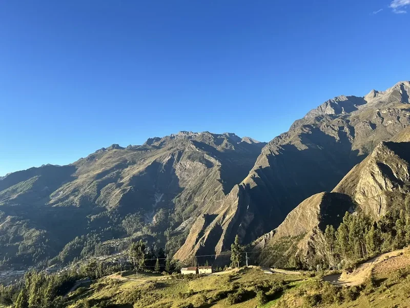
The trek typically begins in the village of Mollepata or the nearby trailhead of Challacancha. The first two days are dominated by the high Andes. Walkers ascend through vast, treeless landscapes known as the Puna, where ichu grass sways in the wind and glacial lagoons like the turquoise Humantay Lake provide stunning photographic opportunities. The crossing of the Salkantay Pass is the physical and emotional crux of the journey. Standing at 4,630 metres, hikers are surrounded by the massive glaciers of Salkantay and Humantay, experiencing the thin air and silence of the high mountains.
From the pass, the trail undergoes a dramatic transformation. Over the course of a single afternoon, the landscape shifts from rock and ice to the "Ceja de Selva" (the eyebrow of the jungle). The temperature rises, the air becomes thick with moisture, and the vegetation explodes into a riot of green. Walkers descend through bamboo forests, past coffee plantations and passionfruit orchards, following the course of the Santa Teresa River. The final approach to Machu Picchu often includes a visit to the Llactapata ruins, which offer a rare, distant view of the citadel across the valley—a perspective few tourists ever see. The journey concludes with a walk along the railway tracks to the bustling town of Aguas Calientes, the gateway to the final ascent to Machu Picchu.
History and Cultural Context
The Salkantay Trek is not merely a scenic route; it is a path steeped in the spiritual geography of the Incan Empire. To the Incas, mountains were not just geological features but living deities known as "Apus." Salkantay was one of the most powerful Apus in the Cusco region, believed to control the weather and the fertility of the crops in the valleys below. Even today, local Quechua-speaking communities maintain a deep reverence for the mountain, often performing "Pagos a la Tierra" (offerings to the Earth) at the high passes to ensure safe passage and a good harvest.
Archaeologically, the Salkantay Trek follows ancient routes that connected the high-altitude pastoral communities with the subtropical agricultural centres of the Vilcabamba region. While it lacks the continuous stone paving of the classic Inca Trail, the route passes through significant sites such as Llactapata. These ruins were rediscovered by Hiram Bingham in 1912, though they were largely forgotten until more recent excavations revealed their importance. Llactapata is believed to have been a "tambo" (resting place) and a ceremonial centre aligned with the sun during the winter solstice, specifically positioned to view Machu Picchu and the sacred peaks.
The modern history of the trek began in the late 20th century as an alternative for those unable to secure the highly competitive Inca Trail permits. However, it has since evolved into a world-class destination in its own right. The development of the "Mountain Lodges of Peru" and various community-led glamping initiatives has transformed the trek from a basic camping trip into a journey that can be experienced with varying levels of comfort, all while maintaining a connection to the local Andean culture and the enduring legacy of the Incan civilisation.
Want more background? Read extended notes on history and cultural context → Learn more
Seasonal Highlights and Weather Reality
The weather on the Salkantay Trek is defined by two distinct seasons: the dry season and the wet season. Because the trail spans a massive elevation range (from 1,900 m to 4,630 m), walkers must be prepared for multiple climates within a single day.
Dry Season (May to September): This is the most popular time to trek. Days are typically clear and sunny, providing the best views of the Salkantay and Humantay peaks. However, the clear skies mean that heat escapes rapidly at night. At the higher campsites like Soraypampa, temperatures frequently drop below freezing (0°C to -5°C). June and July are the driest months but also the coldest. This is the peak tourist season, so the trail and campsites will be at their busiest.
Shoulder Seasons (April and October): These months offer a balance between manageable crowds and relatively stable weather. April marks the end of the rains, resulting in exceptionally green landscapes and blooming wildflowers. October sees the transition back to the wet season, with increasing humidity and occasional afternoon showers.
Wet Season (November to March): Trekking during this time is challenging and requires high-quality waterproof gear. Rain can be persistent, particularly in the cloud forest sections, and clouds often obscure the mountain views. The trail can become muddy and slippery, and there is an increased risk of landslides in the steeper valleys. However, the temperatures are generally warmer at night, and the trail is far less crowded. Many tour operators continue to run treks during this time, but walkers should be prepared for wet conditions and potential itinerary changes.
Regardless of the season, the "Savage Mountain" earns its name through unpredictability. Snow can fall on the Salkantay Pass even in the height of summer, and intense tropical sun can lead to rapid dehydration in the lower valleys. Layering is the essential strategy for managing these extremes.
Recommended Itinerary
5-Day Salkantay Trek Itinerary
Day 1: Mollepata / Challacancha to Soraypampa
- Distance: 12 km
- Elevation gain: 700 m
- Time: 5–6 hours
- Early morning drive from Cusco (approx. 3 hours) to Mollepata for breakfast
- Continue to Challacancha trailhead to begin the walk
- Gentle ascent along an ancient Incan water channel with views of the Humantay glacier
- Arrive at Soraypampa (3,900 m), the highest campsite of the trek
- Afternoon side trip: Steep 1.5-hour climb to the turquoise Humantay Lake (4,200 m)
- Return to Soraypampa for a cold night under the stars
Day 2: Soraypampa to Chaullay via Salkantay Pass
- Distance: 22 km
- Elevation: 730 m gain to pass, 1,700 m descent
- Time: 8–10 hours
- The most challenging day of the trek, beginning with the "Seven Snakes" switchbacks
- Reach the Salkantay Pass (4,630 m), the highest point of the journey
- Spectacular views of the 6,271 m Salkantay peak and surrounding glaciers
- Long, rocky descent into the Huayracmachay valley for lunch
- Continue descending as the landscape shifts from alpine rock to high-altitude cloud forest
- Arrive at Chaullay (2,900 m), nestled in the lush greenery of the valley
Day 3: Chaullay to Lucmabamba (The Coffee Trail)
- Distance: 18 km
- Elevation: 800 m descent
- Time: 5–6 hours
- Walk through the "Ceja de Selva" (eyebrow of the jungle) following the Santa Teresa River
- Pass through plantations of coffee, granadilla (passionfruit), and avocados
- Observe diverse birdlife and wild orchids along the trail
- Cross several waterfalls and small wooden bridges
- Arrive at Lucmabamba (2,100 m)
- Optional: Afternoon visit to a local coffee farm to learn about the roasting process
- Optional: Take a local bus to the Cocalmayo Hot Springs in Santa Teresa for a soak
Day 4: Lucmabamba to Aguas Calientes via Llactapata
- Distance: 15 km
- Elevation: 700 m gain, 900 m descent
- Time: 6–7 hours
- Ascend an original Incan trail through dense forest to the Llactapata pass
- Explore the Llactapata ruins and enjoy the first distant view of Machu Picchu
- Steep descent through bamboo forests to the Aobamba River
- Lunch at the Hidroelectrica station
- Final 10 km flat walk along the railway tracks to Aguas Calientes (2,000 m)
- Evening in a hotel and dinner in the town
Day 5: Machu Picchu to Cusco
- Distance: 4 km (optional walk) or bus ride
- Elevation: 400 m gain (if walking)
- Time: 2–4 hours for the tour
- Early morning bus or walk up to the Machu Picchu citadel
- Guided tour of the main sectors (Temple of the Sun, Intihuatana, Royal Quarters)
- Optional: Climb Huayna Picchu or Machu Picchu Mountain (requires separate pre-booked permit)
- Return to Aguas Calientes by bus or foot
- Afternoon train to Ollantaytambo and bus transfer back to Cusco
Important Notes:
- Altitude acclimatisation in Cusco (minimum 2 days) is essential before starting
- The descent on Day 2 is very hard on the knees; trekking poles are highly recommended
- Water can be purchased at various points on Days 1, 3, and 4, but treatment is necessary for stream water
- Machu Picchu entry tickets must be booked months in advance
- The walk from Hidroelectrica to Aguas Calientes is flat but can be hot and humid
Planning and Bookings
Book Your Trip
Everything you need to plan your journey
Accommodation
Find places to stay near Cusco
Flights
Search flights to Cusco
Essential Preparation
The Salkantay Trek requires significant physical preparation and logistical coordination. Unlike the Inca Trail, you do not strictly need a guide to walk the path, but the vast majority of trekkers choose an organised tour for ease of transport, equipment, and safety. If going independent, you must arrange your own transport to Mollepata and ensure you have a reliable GPS map, as some trail junctions in the lower valleys can be confusing.
Fitness is paramount. You will be walking for 6–10 hours a day at high altitudes. Cardiovascular training and hill walking with a weighted pack in the months leading up to the trip are highly recommended. Furthermore, you must spend at least 48 to 72 hours in Cusco (3,400 m) prior to the trek to allow your body to adjust to the thin air. Attempting the Salkantay Pass without acclimatisation is dangerous and often leads to Acute Mountain Sickness (AMS).
Logistically, you should base yourself in Cusco. Most tour operators include a pre-trek briefing the night before departure. Ensure your travel insurance specifically covers high-altitude trekking up to 5,000 metres, as many standard policies exclude activities above 3,000 metres.
Trail Accommodation
Accommodation on the Salkantay Trek has evolved significantly. Depending on your budget and choice of operator, you may stay in basic tents, glass-roofed "Sky Domes," or luxury lodges.
Campsites and Domes:
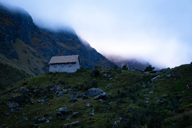
- Soraypampa: The first night is the coldest. Many operators now use permanent structures like Sky Domes or Andean Huts to provide better insulation than standard tents. Facilities are basic, with shared toilets and usually no showers.
- Chaullay/Colpapampa: These campsites are in the cloud forest. They are warmer but can be damp. Some sites offer very basic cold showers and small shops selling snacks and beer.
- Lucmabamba: Often located near coffee farms. These sites are lower and warmer. Some community-run campsites here offer hot showers for a small fee (approx. 10 Soles).
- Aguas Calientes: The final night is spent in a hotel or hostel in the town. This is included in most tour packages.
What is Provided (Organised Tours): Most tours provide tents, foam or inflatable mattresses, and all meals. High-end "Lodge-to-Lodge" treks provide heated rooms, private bathrooms, and gourmet dining.
What is NOT Provided: Sleeping bags are usually available for rent but not included in the base price. Towels, toiletries, and pillows are rarely provided at campsites. Electricity for charging devices is non-existent at the first two campsites, though some domes may have limited solar power.
Required Gear
- Trekking Boots: Waterproof and well broken-in. The terrain varies from loose scree to muddy jungle paths.
- Trekking Poles: Essential for the 1,700 m descent on Day 2 to protect your knees.
- Layered Clothing: Moisture-wicking base layers, a warm fleece or down jacket for the nights, and a breathable waterproof shell.
- Backpack: A 30–40L daypack if you have porters/mules, or a 60L+ pack if trekking independently.
- Head Torch: Essential for early morning starts and navigating campsites at night.
- Sun Protection: High SPF sunscreen, lip balm with SPF, and a wide-brimmed hat. The Andean sun is exceptionally strong.
- Cold Weather Gear: Warm beanie, gloves, and thermal underwear for the first two nights.
What to Bring
- Water Treatment: Purification tablets or a filter (like a Sawyer Squeeze or LifeStraw). Stream water is contaminated by livestock.
- Snacks: Energy bars, nuts, and dried fruit. While meals are provided on tours, you will want extra calories during the long climbs.
- Coca Leaves or Candy: A local remedy for altitude; chewing leaves or drinking coca tea helps with oxygen absorption.
- Personal First Aid: Blister kits (Compeed), ibuprofen, rehydration salts, and any personal medications.
- Insect Repellent: Essential for the lower valleys (Day 3 and 4) where "biting midges" are prevalent.
- Cash (Peruvian Soles): Small denominations for tips, snacks, hot showers, and the Cocalmayo hot springs.
- Power Bank: To keep your phone/camera charged throughout the trek.
- Toilet Paper and Hand Sanitiser: Public toilets on the trail are basic and rarely stocked.
Permits
One of the primary advantages of the Salkantay Trek is that it does not require a specific trekking permit like the Inca Trail. This means it can often be booked at shorter notice. However, you still need several critical documents and bookings to complete the journey and visit Machu Picchu.
Machu Picchu Entry Tickets: This is the most important permit. Tickets are sold for specific time slots and circuits. During the peak season (May–September), these tickets sell out months in advance. If you are booking through an operator, they will usually handle this, but you must provide your passport details early. If going independent, you must book via the official government website (joinnus.com or the official Ministerio de Cultura site).
Huayna Picchu / Machu Picchu Mountain: If you wish to climb one of the peaks overlooking the ruins, you need a specific "Circuit + Mountain" ticket. These are extremely limited (usually 200–400 per day) and must be booked 3–4 months in advance.
Trail Fees: There is a small entrance fee for the Mollepata district (approx. 20 Soles) and sometimes a fee for the Llactapata section. These are usually paid in cash at checkpoints on the trail.
Train Tickets: The return journey from Aguas Calientes to Ollantaytambo/Cusco via PeruRail or Inca Rail should be booked in advance, especially the afternoon trains which are in high demand.
Passport: You must carry your original physical passport. You will need it to start the trek, to stay in hotels, and most importantly, to enter Machu Picchu. A photocopy is not sufficient for the citadel entrance.
Other Activities in the Area
Cusco is the archaeological capital of the Americas, and there is much to see before or after your trek:
- Sacred Valley Tour: Visit the impressive ruins of Pisac and Ollantaytambo, and the salt mines of Maras. This is excellent for acclimatisation.
- Rainbow Mountain (Vinicunca): A popular but strenuous day trip to see the multi-coloured mineral stripes of the high Andes (5,200 m).
- Cusco City Tour: Explore the Qorikancha (Temple of the Sun), the Cathedral, and the massive stone walls of Saqsaywaman.
- Cocalmayo Hot Springs: Located near Santa Teresa, these are considered the best natural springs in the region—perfect for soothing muscles on Day 3 or 4 of the trek.
- San Pedro Market: A vibrant local market in Cusco where you can try local foods, buy alpaca wool products, and see the incredible variety of Andean produce.
- Cooking Classes: Learn to make Peruvian staples like Lomo Saltado or Causa, often including a market visit.
Safety and Conditions
Altitude Sickness (AMS): This is the primary safety concern. Symptoms include headaches, nausea, dizziness, and fatigue. The best prevention is slow ascent, hydration, and proper acclimatisation in Cusco. If symptoms become severe (vomiting, confusion, shortness of breath at rest), the only cure is immediate descent. Most organised tours carry emergency oxygen and have protocols for evacuation by mule or horse.
Terrain and Weather: The Salkantay Pass can be covered in snow or ice, making the "Seven Snakes" switchbacks slippery. High-quality footwear is non-negotiable. In the lower jungle sections, heavy rain can cause small landslides or make the trail extremely muddy. Always check the weather forecast in Cusco before departing, but be prepared for the mountains to ignore the forecast.
Water Safety: Never drink untreated water from streams or taps. Giardia and other water-borne parasites are common due to the presence of mules and cattle throughout the trail. Use a reliable filtration system or purification tablets.
Insects: In the lower valleys (Santa Teresa and Lucmabamba), small biting midges (locally called "mosquitos") are relentless. Their bites are extremely itchy and can last for weeks. Wear long sleeves and trousers, and use a high-DEET repellent.
Emergency Communication: Mobile signal is non-existent for most of the trek until you reach the Santa Teresa valley. If trekking independently, consider carrying a satellite messenger (like a Garmin inReach). Organised groups usually have radio or satellite communication for emergencies.
Side Trips and Points of Interest
Humantay Lake: A stunning glacial lake located at 4,200 m. Most trekkers visit this as an afternoon excursion on Day 1. The climb is steep but the reward is a mirror-like turquoise lake framed by the hanging glaciers of Mount Humantay. It is one of the most photographed spots in Peru.
Llactapata Ruins: Unlike the crowded ruins of the Sacred Valley, Llactapata offers a sense of discovery. Reached on Day 4, these ruins sit directly across the valley from Machu Picchu. Standing here, you can see the citadel, the Huayna Picchu peak, and the Aobamba valley in one panoramic view. It provides a unique archaeological context to the journey.
Coffee Farms of Lucmabamba: The lower Salkantay valley is famous for its high-altitude organic coffee. Many local families have opened their farms to trekkers. You can participate in the harvest (depending on the season), peel the beans, roast them over an open fire, and grind them for the freshest cup of coffee you will ever experience.
The "Gringo Trail" Railway Walk: The final 10 km from Hidroelectrica to Aguas Calientes follows the winding Urubamba River. While flat, the scenery is spectacular, with the granite cliffs of the Machu Picchu sanctuary towering above you. Look out for the "Cock-of-the-Rock," Peru's national bird, which is often seen in the trees along the river.
Leave No Trace
The Salkantay Trek passes through fragile alpine ecosystems and sensitive cloud forests. With thousands of trekkers every year, the environmental impact is significant. It is the responsibility of every walker to minimise their footprint.
Guidelines for the Salkantay Trek:
- Waste Management: Pack out all trash. Do not leave fruit peels or nut shells, as they take a long time to decompose in the cold, high-altitude environment and can disrupt local wildlife.
- Water Protection: Do not use soap or shampoo in the glacial lakes or streams. Even biodegradable soap can harm delicate aquatic ecosystems. Wash at least 60 metres away from water sources.
- Stay on the Path: The Puna (high grassland) is easily eroded. Stick to the established trail to prevent multiple paths from forming and destroying native vegetation.
- Respect Wildlife: You may see Andean Condors, Vizcachas (mountain rabbits), or even the elusive Spectacled Bear. Observe from a distance and never attempt to feed them.
- Human Waste: Use the toilets provided at campsites. If you must go on the trail, dig a "cathole" 15–20 cm deep at least 60 metres from water and trails, and pack out your toilet paper in a sealed bag.
- Cultural Respect: Do not touch or climb on Incan stone walls at Llactapata or Machu Picchu. These structures are centuries old and easily damaged.