Salar de Uyuni Traverse - Walking the White Void
The Salar de Uyuni Traverse is perhaps the most surreal trekking experience on Earth—a 60.0 km journey across the world’s largest salt flat, situated at a staggering 3,656 metres above sea level in the Altiplano of southwestern Bolivia. Spanning over 10,000 square kilometres, this prehistoric dried lake bed offers a landscape of blinding white hexagonal salt tiles, punctuated only by ancient "islands" that are actually the tops of submerged volcanoes covered in giant cacti. Unlike traditional mountain treks, the Salar de Uyuni Traverse is a test of mental endurance and navigation, where the horizon disappears into a seamless blend of earth and sky. It is a place where perspective is lost, and the sheer scale of the wilderness becomes a physical presence. This is not merely a walk; it is an expedition into a high-altitude desert that demands meticulous planning, physical resilience against the elements, and a deep respect for one of the most fragile ecosystems in the Andes.
- Distance: 60.0 km (variable based on route)
- Duration: 3–4 days
- Season: April to November (dry season is essential for walking)
- Accommodation: Wild camping on the salt or basic refugios on peripheral islands
- Highest point: 3,656 m (plateau level), higher if summiting Tunupa Volcano
- Difficulty: Moderate (physically flat, but environmentally extreme)
- Direction: Typically East to West (Colchani to Llica)
Overview
The Salar de Uyuni is a geological marvel, the remnant of several prehistoric lakes that evaporated tens of thousands of years ago, leaving behind a crust of salt several metres thick that contains over half of the world's known lithium reserves. For the trekker, however, the Salar is less a mineral resource and more a psychological frontier. The traverse typically begins near the village of Colchani on the eastern edge and cuts across the heart of the flats toward the "islands" of Incahuasi or Isla Pescado, eventually concluding on the western shores near Llica. The terrain is almost perfectly flat, with an elevation variance of less than one metre across the entire 10,000 square kilometres, creating a sensation of walking on a frozen, white ocean.
The experience is defined by the "white-out" effect—not from snow, but from the reflective power of the salt. Under the intense Altiplano sun, the ground reflects nearly 80% of UV radiation, making high-quality eye protection and skin coverage mandatory. The silence is absolute; away from the occasional distant hum of a 4x4 tour vehicle, the only sound is the crunch of salt crystals beneath your boots. The lack of visual landmarks makes navigation by GPS or compass essential, as the human brain struggles to estimate distance in an environment where a mountain 50 kilometres away looks as though it is within an hour's reach.
While most visitors experience the Salar via motorised tours, walking the traverse allows for a profound connection with the landscape. You witness the subtle changes in the salt patterns—from the classic "honeycomb" hexagons formed by the drying process to the "Ojos del Salar" (Eyes of the Salt), where groundwater bubbles up through the crust. At night, the Salar transforms. The temperature plummets well below freezing, but the reward is a celestial display of the Milky Way so bright it casts shadows on the white ground. This trek is a journey of minimalism, requiring walkers to carry all their water and supplies through a void that is as beautiful as it is unforgiving.
History and Cultural Context
The history of the Salar de Uyuni is inextricably linked to the Aymara people, who have inhabited the Altiplano for millennia. According to local legend, the Salar was formed from the tears and breast milk of the goddess Tunupa, a nearby volcano, after she was abandoned by her husband, Kusku. The salt is seen not just as a mineral, but as a sacred substance. For centuries, "saleros" (salt miners) have harvested the crust using traditional methods, creating small mounds to dry before transporting the salt by llama caravan to the valleys of Bolivia to trade for coca leaves, maize, and wood. Even today, you can see these traditional mounds near Colchani, though modern trucks have largely replaced the llama trains.
Geologically, the Salar is the result of the transformation of several prehistoric lakes. Lake Minchin (40,000 years ago) and Lake Tauca (11,000 years ago) once covered this entire region. When they dried up due to tectonic shifts and climatic changes, they left behind the massive salt deposits we see today. Beneath the solid crust lies a liquid brine rich in lithium, potassium, and magnesium. This has placed the Salar at the centre of global economic interest, as Bolivia holds a significant portion of the world's lithium—a key component in electric vehicle batteries. The tension between industrial development and the preservation of this unique landscape is a defining feature of the region's modern history.
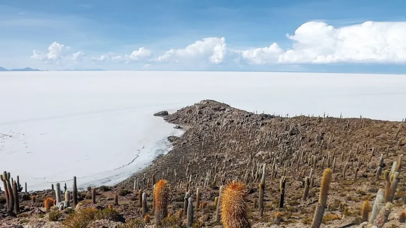
The "islands" within the Salar, such as Incahuasi, serve as archaeological treasure troves. These outcrops of coral-like volcanic rock are covered in Trichocereus pasacana cacti, some of which are over 1,000 years old. They contain remains of ancient Aymara ceremonial sites and provide a glimpse into how humans have navigated this "sea of salt" for generations. Walking the traverse is, in many ways, following the ancient paths of the llama caravans, albeit with modern gear and a different purpose.
Want more background? Read extended notes on history and cultural context → Learn more
Seasonal Highlights and Weather Reality
The Salar de Uyuni has two distinct seasons, and for the trekker, the choice between them is a matter of safety and feasibility. The dry season (April to November) is the only time a full traverse on foot is recommended. During these months, the salt crust is hard, dry, and stable. The skies are almost perpetually clear, providing the best conditions for navigation and photography. However, this is also the coldest time of year. In June and July, night-time temperatures on the salt can drop to -15°C or even -20°C, accompanied by fierce, biting winds that sweep across the Altiplano.
The wet season (December to March) brings a different phenomenon: the "mirror effect." A thin layer of water covers the salt, creating a perfect reflection of the sky. While this is visually stunning and draws thousands of tourists in vehicles, it is extremely difficult and dangerous for walkers. The water is highly alkaline and can cause chemical burns to the skin and damage to footwear and gear. Furthermore, the salt becomes soft and slushy, making walking exhausting and increasing the risk of breaking through the crust into the brine below. Navigation also becomes significantly harder as the horizon line disappears entirely.
Shoulder months like April and November offer a compromise, with slightly warmer temperatures and a lower chance of rain, though the wind remains a constant factor. Regardless of the month, the Altiplano weather is characterised by extreme diurnal temperature swings. You may be walking in a t-shirt under a burning sun at midday (20°C) and wearing four layers of down and wool by 8:00 PM. The air is incredibly dry, which accelerates dehydration and can cause skin and lips to crack within hours if not protected.
Recommended Itinerary
4-Day Salar de Uyuni Traverse Itinerary
Day 1: Colchani to the Salt Flats Interior
- Distance: 15 km
- Elevation gain: 10 m
- Time: 4–5 hours
- Start in the salt-processing village of Colchani
- Visit the "Ojos del Salar" (bubbling groundwater vents)
- Walk past the first "Salt Hotel" (now a museum) and the Dakar Rally monument
- Head due west into the white expanse, leaving the tracks of tour vehicles behind
- Set up camp on the open salt crust, ensuring you are well away from any vehicle corridors
- Experience your first sunset on the salt, where the white ground turns shades of pink and orange
Day 2: The Deep White to Isla Incahuasi
- Distance: 20 km
- Elevation gain: 50 m (on the island)
- Time: 6–7 hours
- A long day of navigation across the featureless centre of the Salar
- Isla Incahuasi will appear as a tiny dark speck on the horizon for hours before you reach it
- The "honeycomb" salt patterns are most pronounced in this central section
- Arrive at Isla Incahuasi, an island of fossilised coral and giant cacti
- Pay the small entry fee to the local community and explore the summit trails for 360-degree views
- Camp near the base of the island or stay in a basic refugio if available
Day 3: Isla Incahuasi to the Western Horizon
- Distance: 15 km
- Elevation gain: 5 m
- Time: 4–5 hours
- Leave the relatively "busy" area of Incahuasi and head toward the western shore
- This section is even more remote, with fewer tour vehicles venturing this far
- The salt crust here can be rougher, with larger crystalline structures
- Aim for a point between Isla Pescado and the mainland
- Wild camp on the salt for the final night, enjoying the absolute silence of the Altiplano
- The stars in this remote section are among the clearest on the planet
Day 4: Final Push to Llica or the Mainland
- Distance: 10 km
- Elevation gain: 20 m
- Time: 3 hours
- Walk toward the volcanic foothills of the western edge
- The salt begins to mix with sand and clay as you approach the shore
- Finish the trek at the edge of the Salar near the town of Llica or a pre-arranged pickup point
- Llica is a traditional Altiplano town where you can find basic transport back to Uyuni
- Celebrate the completion of the traverse with a hot meal and plenty of hydration
Important Notes:
- GPS is mandatory; do not rely on visual landmarks as they are deceptive
- You must carry all water (minimum 5–6 litres per day) as there are no sources on the salt
- Sun protection must be reapplied every 2 hours
- Camping on the salt requires a high-quality, four-season tent and a sleeping bag rated to -15°C
- Notify a local contact in Uyuni of your planned route and expected return time
Planning and Bookings
Book Your Trip
Everything you need to plan your journey
Accommodation
Find places to stay near Uyuni
Flights
Search flights to Uyuni
Essential Preparation
The Salar de Uyuni Traverse is an unsupported expedition in a high-altitude desert. The most critical preparation is acclimatisation. Uyuni sits at 3,656 metres, and many trekkers arrive from lower elevations. It is essential to spend at least 3–4 days at altitude (in Uyuni, La Paz, or Potosí) before starting the walk. Altitude sickness (soroche) can be fatal, and the physical exertion of walking on the Salar will exacerbate any symptoms.
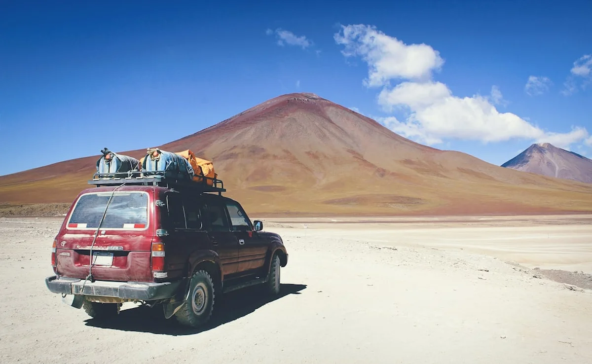
Logistics are the second major challenge. There are no water sources on the Salar. For a 4-day trek, you would need to carry approximately 20–24 litres of water, which is physically impossible for most. Therefore, you must either hire a support vehicle to meet you at designated points or arrange "water drops" in advance with a local tour operator. Coordination with a reputable agency in Uyuni is highly recommended to ensure your survival supplies are where they need to be.
Trail Accommodation
Accommodation on the Salar de Uyuni Traverse is primarily wild camping, which requires specialised equipment and a high tolerance for cold.
Camping on the Salt:
- No designated campsites exist on the open salt flats.
- You must use a free-standing tent, as standard tent pegs cannot penetrate the hard salt crust (use heavy dry bags filled with salt or rocks as anchors).
- A high-R-value sleeping mat (or two) is essential to insulate your body from the frozen ground.
- Temperatures inside the tent will regularly drop below zero.
Isla Incahuasi Refugios:
- Basic dormitory-style accommodation is sometimes available on Isla Incahuasi, managed by the local community.
- Facilities are extremely limited: shared pit toilets, no showers, and no heating.
- Electricity is usually provided by solar panels and is only available for a few hours in the evening.
- Costs are low (approx. 50–100 Bolivianos), but availability is not guaranteed and cannot be booked online.
Salt Hotels:
- Located on the periphery (near Colchani), these are luxury or mid-range options made entirely of salt blocks.
- These are excellent for the night before or after your trek but are not located along the walking route itself.
Required Gear
- GPS Device - with spare batteries and pre-loaded offline maps (essential for navigation)
- Four-season tent - must be wind-resistant and free-standing
- Sleeping bag - rated to -15°C (comfort rating, not extreme)
- Insulated sleeping mat - R-value of 4.0 or higher
- High-altitude mountaineering sunglasses - Category 4 lenses with side shields (standard sunglasses are insufficient)
- Sturdy hiking boots - waterproof and well-broken in; the salt is abrasive
- Multi-fuel stove - gas canisters can struggle in extreme cold and high altitude; white gas or benzine is more reliable
- Power bank - cold drains batteries rapidly; keep electronics inside your sleeping bag at night
- Satellite messenger (e.g., Garmin inReach) - there is no mobile signal in the centre of the Salar
What to Bring
- Water - 5 to 6 litres per person per day (non-negotiable)
- High-calorie food - dehydrated meals, nuts, chocolate, and energy bars (digestion is slower at altitude)
- Electrolyte powder - to prevent dehydration in the dry Altiplano air
- Sunscreen - SPF 50+ and zinc for nose and lips
- Lip balm - with UV protection (essential to prevent painful cracking)
- Moisturiser - the salt and dry air will strip moisture from your skin
- Clothing layers - merino wool base layers, heavy fleece mid-layer, down jacket, and a windproof/waterproof shell
- Warm hat and gloves - plus a buff or balaclava to protect your face from wind and sun
- Personal first aid kit - including altitude medication (Acetazolamide), blister kits, and broad-spectrum antibiotics
- Biodegradable wet wipes - for "showering," as water is too precious to waste on washing
Permits
Currently, there is no formal permit required by the Bolivian government to walk across the Salar de Uyuni. However, this does not mean the area is unregulated. The Salar is managed by local communities and the regional government of Potosí, and certain rules must be followed to ensure safety and environmental protection.
Local Fees and Access:
- Isla Incahuasi: There is an entry fee of approximately 30 Bolivianos (approx. £3.50 / $4.50) to access the island and its trails. This fee supports the local community that maintains the facilities and protects the ancient cacti. Keep your receipt, as it may be checked.
- Colchani: While there is no fee to enter the Salar from Colchani, you should be respectful of the salt-mining areas, which are the livelihoods of the local people.
- Registration: It is highly recommended (though not legally mandated) to register your trek with the Tourist Police (Policía Turística) in Uyuni. Provide them with your itinerary, equipment list, and emergency contact details.
Logistical Coordination:
- If you are arranging water drops or a support vehicle, ensure your operator has the necessary licenses to operate on the Salar. Unauthorised vehicles can be fined, which may disrupt your trek.
- If you plan to summit Tunupa Volcano as part of your trip, additional local fees may apply at the village of Coqueza.
Customs and Regulations:
- Bolivia has strict rules regarding the export of natural resources. While taking a small handful of salt as a souvenir is generally overlooked, attempting to remove large quantities or geological samples is prohibited.
- Respect the "No Drone" zones if they are posted, particularly around sensitive wildlife areas or near the lithium extraction plants.
Other Activities in the Area
The Salar de Uyuni is the gateway to the Eduardo Avaroa Andean Fauna National Reserve, one of Bolivia's most spectacular regions. Consider these additions to your trip:
- Laguna Colorada: A stunning red-coloured lake filled with thousands of James's, Andean, and Chilean flamingos. The colour comes from algae and red sediments in the water.
- Sol de Mañana Geysers: A high-altitude geothermal field with bubbling mud pots and steam vents, best visited at sunrise when the steam is most dramatic.
- Laguna Verde: A brilliant turquoise lake at the foot of the Licancabur Volcano. The colour is caused by high concentrations of lead, magnesium, and arsenic.
- The Train Cemetery (Cementerio de Trenes): Located just outside Uyuni, this is a collection of rusted 19th-century steam locomotives that once transported minerals to the Pacific coast.
- Tunupa Volcano: For those seeking more elevation, a hike to the viewpoint or the crater of this 5,321 m volcano offers the best aerial perspective of the Salar.
- Stargazing Tours: Even if you are trekking, a dedicated photography tour can provide professional equipment to capture the incredible night sky of the Altiplano.
Safety and Conditions
Altitude and Environment:
- The Salar sits at over 3,600 m. Acute Mountain Sickness (AMS) is a genuine risk. Symptoms include headache, nausea, and dizziness. If symptoms worsen, the only cure is descent—which is difficult on the flat Salar. Carry oxygen if possible and know the signs of HAPE and HACE.
- Dehydration happens rapidly in the 10% humidity of the Altiplano. You must drink even if you don't feel thirsty.
- The sun is exceptionally strong. Snow blindness (or "salt blindness") can occur within hours without Category 4 sunglasses.
Navigation Hazards:
- The "White Void" causes a total loss of depth perception. Objects that look 1 km away may be 10 km away. Never walk without a GPS heading.
- Mirages are common in the heat of the afternoon, making distant mountains appear to float or change shape.
- If a dust storm (viento blanco) occurs, visibility can drop to zero. Carry an emergency shelter and stay put until the wind dies down.
Temperature Extremes:
- Hypothermia is a risk even after a warm day. Once the sun sets, the temperature drops at a rate of about 5°C per hour.
- Ensure your stove is capable of melting ice or heating water in sub-zero temperatures; if your stove fails, you cannot hydrate.
Emergency Contacts:
- There is no reliable mobile coverage on the Salar. A satellite communication device (Garmin inReach, Zoleo, or Satellite Phone) is the only way to call for help.
- The nearest hospital with advanced facilities is in Potosí (3–4 hours from Uyuni) or La Paz. Ensure your travel insurance covers high-altitude trekking and emergency heli-evacuation.
Side Trips and Points of Interest
Isla Pescado: Often confused with Incahuasi, Isla Pescado is a larger, much less visited island located about 20 km further west. It is named for its fish-like shape when viewed from a distance. It offers complete solitude and even larger cacti than Incahuasi, making it a perfect detour for those who want to escape the tour jeep routes.
The Ojos del Salar: These "Eyes of the Salt" are small, circular openings in the crust where cold water from underground rivers bubbles to the surface. The water is highly acidic and often surrounded by colourful mineral deposits. They are fascinating geological features but be careful not to step too close, as the edges can be unstable.
Galaxy Caves (Grutas de las Galaxias): Located on the periphery of the Salar near the village of Aguaquiza, these caves feature unique sub-aquatic limestone formations that look like bone or coral, formed when the region was still covered by prehistoric lakes. Nearby are ancient Chullpas (Aymara burial towers).
Colchani Salt Museum: A small, locally-run museum in the village where you can learn about the salt extraction process and see sculptures made entirely of salt. It provides excellent context before you begin your walk into the void.
Leave No Trace
The Salar de Uyuni is a fragile prehistoric landscape. While it may look like a vast, indestructible wasteland, the salt crust and the life on the islands are highly sensitive to human impact. The growth rate of the Trichocereus cacti is only 1 centimetre per year; a cactus that is 10 metres tall has been standing since the time of the Crusades.
Your responsibility as a walker:
- Human Waste: This is the most critical issue. Waste does not decompose in the dry, salty environment. You MUST use a "wag bag" system (pack-it-out) for all solid human waste. Do not bury it; the salt will simply preserve it for years.
- Trash: Pack out every single item, including organic waste like orange peels or nut shells, which will not decompose here.
- Salt Crust: Avoid breaking the hexagonal ridges of the salt where possible. While vehicles do more damage, a large group of hikers can also scar the surface.
- Wildlife: Do not feed the Andean foxes (culpeos) or viscachas found on the islands. Feeding them disrupts their natural hunting patterns and makes them dependent on humans.
- Water: Do not use soap (even biodegradable) in the Ojos del Salar or any water holes on the islands. These are vital water sources for local birds and animals.
- Cacti: Never touch or lean on the giant cacti. Their spines are their only defence, and they are easily damaged by human contact.