USA — Seattle, Washington
Ascend the Sahale Arm Trail in Washington's North Cascades National Park for unparalleled "American Alps" vistas. This demanding 18.5 km out-and-back route climbs through ancient temperate rainforests and vibrant subalpine meadows, culminating in a high-alpine world of rock and ice. Expect a significant 1,524-metre ascent and breathtaking panoramas on this iconic Pacific Northwest hike.
Distance: 18.5 km
Elevation Gain: 1524 m
Difficulty: Challenging
Duration: 6-8 hours
The Sahale Arm Trail is widely considered the most spectacular day hike in the United States' Pacific Northwest, offering an unparalleled window into the "American Alps." Located in the heart of North Cascades National Park in Washington State, this 18.5 km out-and-back journey ascends through a dramatic sequence of ecosystems, from ancient temperate rainforests to vibrant subalpine meadows, finally culminating in a high-alpine world of rock and ice. The trail gains a staggering 1,524 metres of elevation, making it a formidable physical challenge that rewards hikers with 360-degree panoramas of jagged, glacier-clad peaks that seem to stretch infinitely toward the horizon. From the turquoise depths of Doubtful Lake to the shimmering expanse of the Sahale Glacier, every kilometre of this route provides a masterclass in glacial geology and mountain majesty. This is not merely a walk; it is an ascent into one of the most rugged and pristine wilderness areas in North America, demanding respect, preparation, and a high level of physical fitness.
The Sahale Arm Trail is a journey of three distinct acts, each more visually arresting than the last. The experience begins at the Cascade Pass Trailhead, situated at the head of the Cascade River Valley. The first section of the trail is a masterfully engineered series of approximately 35 switchbacks that climb steadily through a dense canopy of Douglas fir, Western red cedar, and Mountain hemlock. This section is designed to gain elevation efficiently while protecting the steep hillside from erosion. As the forest thins, hikers emerge onto Cascade Pass, a historic mountain crossing that serves as a natural balcony overlooking the Stehekin Valley and the surrounding peaks of the North Cascades. For many, the pass is a worthy destination in itself, but for those seeking the full Sahale experience, it is merely the gateway.
From Cascade Pass, the trail turns north and begins its ascent of the "Arm" itself. This is where the landscape transforms into a subalpine wonderland. In late summer, the meadows here are a riot of colour, with lupine, heather, and Indian paintbrush creating a vibrant carpet against the grey granite of the peaks. The trail follows the narrow spine of the ridge, offering dizzying views down into the cirque containing Doubtful Lake—a brilliant sapphire gem nestled 300 metres below the trail. The final push to the Sahale Glacier Camp is the most demanding, as the vegetation disappears, replaced by a stark, lunar landscape of scree, talus, and polished rock. At the top, hikers stand at the foot of the Sahale Glacier, surrounded by some of the most iconic summits in the range, including Johannesburg Mountain, Mount Formidable, and Magic Mountain.
The North Cascades are unique for their sheer density of glaciers—containing more than half of all the glaciers in the lower 48 United States. The Sahale Arm provides one of the most accessible ways to witness this icy landscape up close. However, the trail's beauty is matched by its difficulty. The elevation gain is relentless, and the high-alpine environment means weather can shift from blistering sun to freezing rain or snow in a matter of minutes. This is a trail for the experienced hiker who values solitude, geological drama, and the raw power of the mountains.
The history of the Sahale Arm and Cascade Pass is deeply intertwined with the indigenous peoples of the region. For millennia, the Skagit tribes from the west and the Chelan and Wenatchi tribes from the east used Cascade Pass as a vital trans-mountain trading route. They crossed these high ridges to exchange coastal resources like dried salmon and seashells for inland goods such as obsidian and bitterroot. The name "Sahale" is derived from a Chinook Jargon word meaning "high" or "above," a fitting descriptor for a trail that reaches into the heavens.
In the late 19th century, the area saw a surge of interest from European-American prospectors. The discovery of silver and lead ore in the surrounding basins led to the establishment of mining claims near Doubtful Lake and the Stehekin Valley. Remnants of this era, including rusted equipment and old mine tailings, can still be found by those who know where to look, though the rugged terrain and harsh winters eventually defeated most commercial mining efforts. The difficulty of transporting ore out of such a vertical landscape proved to be an insurmountable barrier to long-term profit.
The modern conservation history of the Sahale Arm began in the mid-20th century as outdoor enthusiasts and conservationists realised the unique value of the North Cascades. The area was eventually protected with the passage of the North Cascades National Park Act in 1968. This legislation ensured that the Sahale Arm would remain a wilderness area, free from the development that has altered so many other mountain ranges. Today, the trail is managed by the National Park Service with a focus on preserving its fragile alpine ecology while allowing hikers to experience its profound beauty. The trail remains a symbol of the enduring wildness of the American West, a place where the hand of man is secondary to the forces of ice and stone.
Want more background? Read extended notes on history and cultural context → Learn more
The window for hiking the Sahale Arm is remarkably short due to its high elevation and the massive amounts of snowfall the North Cascades receive each winter. Typically, the trail is only fully accessible from mid-July through late September. Even in July, hikers should expect to encounter significant snow patches, particularly on the upper sections of the Arm and near the glacier camp. Ice axes and traction devices are often necessary well into the summer months.
Spring (May to June): During this period, the trail is largely buried under several metres of snow. The Cascade River Road, which provides access to the trailhead, often remains closed due to snow or avalanche debris until late June. Hiking during this time is considered a technical mountaineering undertaking rather than a standard trek.
Summer (July to August): This is the peak season. July brings the emergence of wildflowers in the lower meadows, while August offers the most stable weather and the clearest views. This is also the time when the local wildlife is most active; marmots can be seen sunning themselves on rocks, and mountain goats frequently traverse the high ridges. However, summer also brings the risk of afternoon thunderstorms, which can be extremely dangerous on the exposed ridge of the Arm.
Autumn (September to October): September is many locals' favourite time to hike. The air is crisp, the bugs have disappeared, and the subalpine blueberries and mountain ash turn brilliant shades of red and gold. The first dustings of "termination dust" (early season snow) usually appear on the peaks by late September. By October, winter begins to reclaim the high country, and the road typically closes for the season after the first major storm.
Winter (November to April): The Sahale Arm is strictly the domain of expert ski mountaineers and winter climbers during these months. Avalanche risk is extreme throughout the Cascade River Valley and on the steep slopes of the Arm. Access requires a long approach on skis or snowshoes from the lower road closures.
Early Morning: The Forest Ascent
Mid-Morning: The Climb to the Arm
Midday: Reaching the Sahale Glacier Camp
Afternoon: The Descent
Important Notes:
The Sahale Arm is a serious undertaking that requires a high level of physical conditioning. The 1,524 metres of elevation gain is concentrated into a relatively short distance, meaning the gradients are often steep and relentless. Hikers should be comfortable with sustained climbing and descending on varied terrain, including loose rock and potentially snow. If you are travelling from sea level, consider spending a day or two at a moderate elevation before attempting this hike to help with acclimatisation.
Logistically, the most important factor is the approach. The Cascade River Road is a 37-kilometre gravel road that can be rough and dusty. While usually passable for standard passenger cars, high-clearance vehicles are preferred. The trailhead parking lot is small and fills up extremely early on summer weekends; if the lot is full, you may have to park further down the road, adding significant distance to your day. The closest town for supplies and fuel is Marblemount, located at the junction of WA-20 and the Cascade River Road. Ensure your vehicle has a full tank of fuel before leaving Marblemount, as there are no services beyond that point.
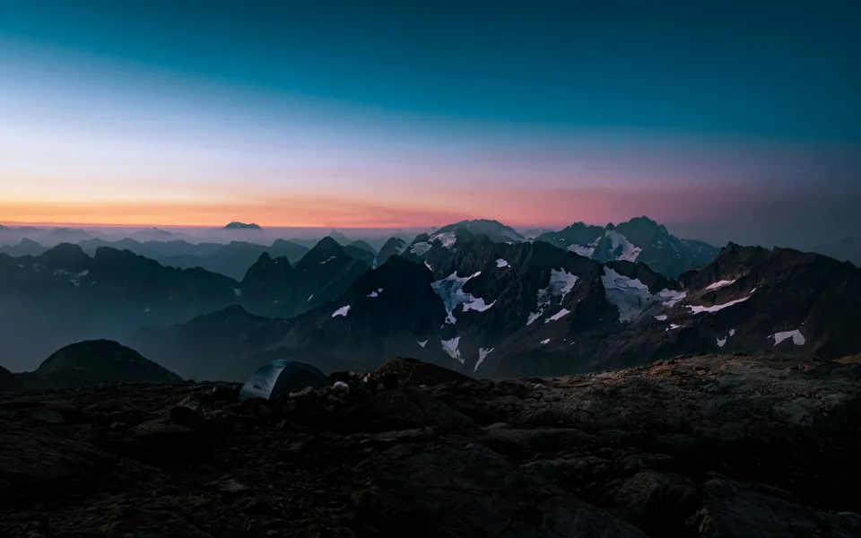
The Sahale Arm is primarily completed as a day hike, but for those wishing to experience a night under the stars in one of the world's most dramatic settings, overnight camping is possible at the Sahale Glacier Camp.
Sahale Glacier Camp: This is a high-alpine camp consisting of several established tent platforms protected by hand-built stone windbreaks. There are no facilities other than a primitive composting toilet (the "throne with a view"). Water must be melted from snow or collected from glacial meltwater (treatment is mandatory). Camping here requires a competitive backcountry permit from the National Park Service.
Nearby Campgrounds: For those day-hiking the trail, there are several drive-in campgrounds along the Cascade River Road and the North Cascades Highway (WA-20). Mineral Park and Marble Creek are the closest to the trailhead. Further afield, Colonial Creek Campground on the shores of Diablo Lake offers excellent facilities but requires advance booking through the NPS website.
Lodging: There are no hotels or lodges within the immediate vicinity of the trailhead. The nearest commercial accommodation is found in Marblemount (small motels and cabins) or further west in the town of Concrete. Many hikers choose to base themselves in the Skagit Valley or even Seattle, though this requires a very early start.
For day hikers, no specific hiking permit is required to walk the Sahale Arm Trail. However, you must display a valid Northwest Forest Pass or an America the Beautiful (National Parks) Pass in your vehicle at the trailhead. These can be purchased at ranger stations, outdoor retailers in Seattle or Marblemount, or online in advance. Failure to display a pass can result in a significant fine.
Backcountry Permits for Overnight Stays:
If you intend to camp at Sahale Glacier Camp or any other backcountry site in North Cascades National Park, a backcountry permit is mandatory. These permits are highly coveted and are managed through a dual system:
Group Size: The maximum group size for backcountry travel in the North Cascades is 12 people. However, for the Sahale Glacier Camp, group sizes are often limited further to protect the fragile alpine environment. Always check the current regulations at the Marblemount Ranger Station before your trip.

Detailed route notes, maps, logistics & tips for the Sahale Arm Trail (PDF).

Precisely traced GPX for the Sahale Arm Trail, ready for your GPS or favourite mapping app.
The North Cascades region offers a wealth of other activities for those looking to extend their stay:
The Sahale Arm is a high-altitude environment where safety must be the primary concern. The most significant risks are weather, terrain, and wildlife.
Weather Hazards: The North Cascades create their own weather systems. A clear morning can quickly turn into a dangerous situation with high winds, lightning, and plummeting temperatures. If you see dark clouds building or hear thunder, descend from the Arm immediately. Lightning is a very real threat on the exposed ridge. Hypothermia is possible even in mid-summer if you become wet and the wind picks up.
Terrain and Rockfall: The final climb to the Sahale Glacier Camp is on loose, unstable rock. Be mindful of hikers above and below you to avoid dislodging stones. If you are crossing snow patches, be aware of "moats"—deep gaps that form between the snow and rock faces—which can be hidden and dangerous to fall into.
Wildlife Encounters:
Cell Service: There is no mobile phone reception at the trailhead or anywhere on the trail. Consider carrying a satellite communication device (like a Garmin inReach) for emergencies. Always leave a detailed trip plan with someone back home.
While the Sahale Arm is the main attraction, there are several notable features along the way:
Doubtful Lake: For those with extra energy, a steep and rugged social trail descends from the Arm down to the shores of Doubtful Lake. This adds about 300 metres of extra climbing on the return journey but offers a chance to swim in the icy glacial waters and experience the cirque from below. The lake is named for the "doubtful" nature of the mining prospects that once surrounded it.
The Sahale Glacier: At the top of the trail, you stand at the edge of the Sahale Glacier. While walking on the glacier itself requires technical mountaineering gear (crampons, ice axe, and rope) and training due to crevasse danger, you can safely enjoy the view of the blue ice and the sound of meltwater rushing beneath the surface from the safety of the camp area.
Pelton Basin: From Cascade Pass, a separate trail leads down into Pelton Basin. This is a lush, meadow-filled valley that is often less crowded than the Sahale Arm and is a great place for birdwatching and spotting bears in the late afternoon.
Johannesburg Mountain: This massive peak dominates the view to the south. It is famous among climbers for its "North Face," one of the most difficult and dangerous alpine faces in the lower 48 states. Watching the frequent ice and rock avalanches tumble down its hanging glaciers from the safety of the Sahale Arm is a humbling experience.
The alpine environment of the Sahale Arm is incredibly fragile. The growing season here is only a few weeks long, and a single footstep off the trail can destroy plants that have taken decades to grow. Following Leave No Trace principles is essential to preserving this landscape.