Ruta de los Volcanes - The Avenue of the Volcanoes
The Ruta de los Volcanes, or the Avenue of the Volcanoes, is Ecuador’s most iconic high-altitude trekking experience. Stretching approximately 450 kilometres through the heart of the Ecuadorian Andes, this route traverses a dramatic volcanic corridor flanked by two parallel mountain ranges—the Cordillera Occidental and the Cordillera Oriental. First named by the German explorer Alexander von Humboldt in 1802, the route offers an unparalleled journey through a landscape of snow-capped peaks, emerald-green paramo grasslands, and deep glacial valleys. This is not merely a walk; it is a high-altitude odyssey that connects some of the world’s highest active volcanoes, including the perfectly symmetrical cone of Cotopaxi and the massive, ice-clad Chimborazo, the point on Earth closest to the sun.
The journey typically begins in the historic capital of Quito, the highest constitutional capital in the world, and winds southward through a series of national parks and ecological reserves. Walkers encounter a diverse array of ecosystems, from the misty cloud forests of the lower slopes to the stark, wind-swept beauty of the high-altitude paramo. The route is physically demanding, requiring significant elevation gains and a high level of cardiovascular fitness, but the rewards are immense. Travellers are treated to sightings of the Andean condor, the elusive spectacled bear, and herds of wild vicuñas roaming the slopes of Chimborazo. Culturally, the trail provides a deep immersion into the lives of the indigenous Kichwa communities who have inhabited these highlands for millennia, maintaining a spiritual connection to the "Apus" or mountain spirits that define their horizon.
- Distance: 450.0 km (total corridor length; typical trekking segments vary)
- Duration: 10–15 days
- Elevation Gain: 25,000 m (cumulative across the full route)
- Difficulty: Challenging (due to altitude and sustained climbing)
- Best Time: June to September (dry season)
- Highest Point: Varies by route; typically reaches 4,800–5,000 m at refugios
- Closest City: Quito, Ecuador
- Trailhead Access: Multiple entry points; primary access via Machachi or Latacunga
Overview
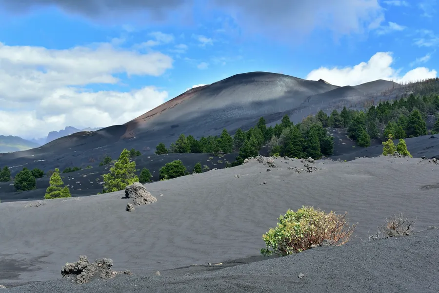
The Ruta de los Volcanes is a masterclass in Andean geography. The route follows the Inter-Andean Valley, a high-altitude depression that separates the two main branches of the Andes in Ecuador. This valley is home to more than thirty volcanoes, many of which remain active today. The trekking experience is characterised by its "staircase" nature—descending into lush, fertile valleys where traditional agriculture thrives, only to climb back up into the thin, crisp air of the high paramo. The landscape is dominated by the "Puna" or "Paramo" ecosystem, a unique high-altitude moorland found only in the northern Andes, which acts as a giant sponge, capturing moisture from the clouds and feeding the rivers that flow to both the Pacific and the Amazon.
Walking the Ruta de los Volcanes is as much a cultural journey as it is a physical one. The trail passes through vibrant highland markets, such as those in Saquisilí or Zumbahua, where the air is thick with the scent of roasted maize and the vibrant colours of hand-woven ponchos. The interaction between the harsh volcanic environment and human settlement is evident everywhere, from the ancient stone walls of Inca ruins to the colonial-era haciendas that now serve as base camps for modern adventurers. The route is not a single, fixed path but a network of trails that can be customised based on the walker's experience and interest, ranging from technical mountaineering ascents to scenic valley traverses.
The physical challenge of the Ruta de los Volcanes cannot be overstated. Most of the trekking occurs at altitudes between 3,000 and 4,800 metres. At these heights, the oxygen levels are significantly lower than at sea level, making every step a conscious effort. The weather is notoriously fickle; a morning of brilliant, high-altitude sunshine can quickly transform into a freezing afternoon of sleet and fog. However, it is this very volatility that creates the route's most spectacular moments—the sight of Cotopaxi’s glacier glowing orange in the dawn light, or the sudden clearing of clouds to reveal the jagged peaks of the Illinizas. For those who seek a journey that tests their limits while providing a profound sense of connection to the earth’s geological power, the Ruta de los Volcanes is unsurpassed.
History and Cultural Context
The history of the Ruta de los Volcanes is a tapestry of indigenous heritage, colonial exploration, and scientific discovery. Long before the arrival of Europeans, the highlands were inhabited by various ethnic groups, including the Caras, Puruhá, and Cañari. These peoples viewed the volcanoes as deities, attributing personalities and familial relationships to the peaks. For example, Chimborazo is often referred to as "Taita" (Father) Chimborazo, while the nearby Tungurahua is "Mama" Tungurahua. The mountains were central to their cosmology, influencing agricultural cycles and spiritual practices. The Inca Empire eventually expanded into this region in the 15th century, incorporating the volcanoes into their vast road network, the Qhapaq Ñan, and building strategic fortifications known as pucaras along the valley ridges.
In 1802, the Prussian polymath Alexander von Humboldt arrived in Quito and spent several months exploring the region. It was Humboldt who famously coined the term "Avenue of the Volcanoes" (Avenida de los Volcanes) to describe the two parallel rows of peaks. His attempt to climb Chimborazo—then believed to be the highest mountain in the world—was a landmark event in the history of science. Although he did not reach the summit, he reached an altitude of 5,875 metres, a world record at the time. Humboldt’s detailed observations of plant geography and the relationship between altitude and climate laid the foundations for modern ecology. His legacy is still felt today, as many of the routes followed by modern trekkers trace the very paths he documented over two centuries ago.
During the colonial era, the Spanish established large agricultural estates, or haciendas, in the fertile valleys between the volcanoes. These estates became the economic backbone of the region, and many of the historic buildings still stand today, some converted into lodges for hikers. The cultural landscape remains deeply influenced by the syncretism of indigenous and Catholic traditions. Festivals such as the Mama Negra in Latacunga or the Inti Raymi (Sun Festival) in the rural highlands provide a window into a world where the rhythms of the earth and the presence of the volcanoes continue to dictate the pace of life. Walking this route is an opportunity to witness this enduring heritage firsthand.
Want more background? Read extended notes on history and cultural context → Learn more
Seasonal Highlights and Weather Reality
Ecuador’s position on the equator means that there are no traditional four seasons; instead, the climate is divided into the "wet" and "dry" seasons. However, in the high Andes, the weather is best described as "four seasons in one day." Regardless of the time of year, trekkers must be prepared for intense equatorial sun, biting winds, and sudden temperature drops.
The Dry Season (June to September): This is widely considered the best time to trek the Ruta de los Volcanes. These months offer the highest probability of clear skies and stable weather, which is crucial for enjoying the panoramic views of the peaks. The "Veranillo" (Little Summer) often brings crisp, cold mornings followed by bright, sunny days. However, this is also the windiest time of year, particularly in the high paramo, where gusts can be powerful enough to make walking difficult. Nighttime temperatures frequently drop below freezing at higher elevations.
The Wet Season (October to May): During these months, rain is more frequent, typically occurring as heavy afternoon downpours. The landscape is at its most vibrant and green during this time, and the wildflowers of the paramo are in full bloom. While the mornings are often clear, clouds tend to roll in by midday, obscuring the volcanic peaks. December and January often see a brief period of improved weather known as the "Veranillo del Niño," which can provide excellent trekking conditions. The wet season requires high-quality waterproof gear and a flexible itinerary to account for potential delays caused by mud or low visibility.
Weather Reality: At altitudes above 4,000 metres, snow can fall at any time of year. Hypothermia is a genuine risk if a walker becomes wet and is exposed to the wind. The equatorial sun is exceptionally strong; even on cloudy days, the UV radiation is high, making sun protection essential. Trekkers should always monitor the reports from the Instituto Geofísico (IG-EPN), as volcanic activity can lead to trail closures or the presence of ash, particularly near active vents like Cotopaxi or Sangay.
Recommended Itinerary
12-Day Ruta de los Volcanes Expedition
Day 1: Quito to Machachi
- Distance: 12 km (acclimatisation walk)
- Elevation gain: 400 m
- Time: 4 hours
- Transfer from Quito to the town of Machachi, the gateway to the southern volcanoes
- Afternoon acclimatisation hike on the lower slopes of Pasochoa
- Walk through high-altitude farmland and cloud forest remnants
- Stay in a local hostal or hacienda to begin the acclimatisation process
- Focus on hydration and slow movement to adjust to the 3,100 m altitude
Day 2: Pasochoa Volcano Ascent
- Distance: 15 km
- Elevation gain: 1,100 m
- Time: 6–7 hours
- Climb to the rim of the ancient, collapsed caldera of Pasochoa (4,200 m)
- The crater contains one of the last remaining primary Andean forests in the region
- Spectacular views of the "Avenue" including Cotopaxi, Sincholagua, and Antisana
- Descent back to Machachi for a second night of acclimatisation
- This day is critical for building the red blood cell count needed for higher elevations
Day 3: Machachi to Cotopaxi National Park
- Distance: 18 km
- Elevation gain: 600 m
- Time: 6 hours
- Enter the northern gate of Cotopaxi National Park
- Trek across the vast volcanic plains of the Limpiopungo plateau
- Observe wild horses and Andean gulls near the Limpiopungo Lake
- The perfectly symmetrical cone of Cotopaxi dominates the horizon
- Arrive at a mountain lodge or campsite within the park boundaries (3,800 m)
Day 4: Cotopaxi Refugio and Glacier Line
- Distance: 8 km
- Elevation gain: 800 m
- Time: 5 hours
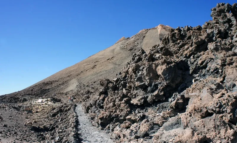
- Steep ascent from the car park to the José Rivas Refugio (4,864 m)
- Continue to the base of the glacier (approx. 5,000 m) to see the ice towers
- Experience the thin air and the dramatic volcanic landscape of red scoria and ash
- Descend back to the valley floor for the night
- This is the highest point for many trekkers and a true test of altitude readiness
Day 5: Cotopaxi to Isinlivi (The Quilotoa Loop Connection)
- Distance: 14 km
- Elevation: 400 m descent, 300 m gain
- Time: 5–6 hours
- Transfer to the start of the Quilotoa Loop section near Sigchos
- Walk along the Toachi River canyon, descending into a warmer microclimate
- Pass through small Kichwa farming communities and eucalyptus groves
- Arrive in the picturesque village of Isinlivi
- Stay in a community-run eco-lodge
Day 6: Isinlivi to Chugchilán
- Distance: 12 km
- Elevation gain: 600 m
- Time: 5–6 hours
- Trek through the heart of the Toachi Canyon
- Cross suspension bridges and climb steep switchbacks out of the canyon
- Pass through the village of Itualo
- Arrive in Chugchilán, a centre for local woodcarving and traditional crafts
- The route offers stunning views of the rugged canyon walls and distant peaks
Day 7: Chugchilán to Quilotoa Crater
- Distance: 11 km
- Elevation gain: 700 m
- Time: 5–6 hours
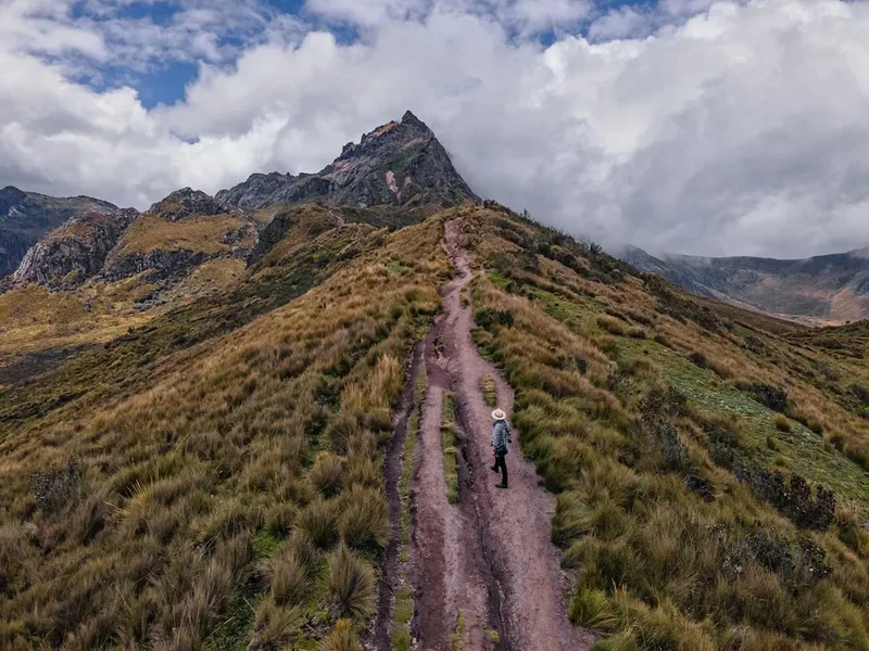
- The most dramatic day of the loop, climbing to the rim of the Quilotoa caldera
- First view of the turquoise crater lake, 400 metres below the rim
- Walk along the narrow, wind-swept rim of the volcano
- Descend into the village of Quilotoa (3,900 m)
- The lake's colour changes from turquoise to deep green depending on the light
Day 8: Quilotoa to Tigua and Transfer South
- Distance: 14 km
- Elevation: Mostly descent
- Time: 4–5 hours
- Walk from the crater towards the village of Tigua
- Tigua is famous for its vibrant paintings on sheepskin, depicting Andean life
- Afternoon transfer by vehicle further south towards the Chimborazo province
- Stay in a mountain lodge near the base of Chimborazo (approx. 4,000 m)
Day 9: Chimborazo Wildlife Reserve - The High Paramo
- Distance: 16 km
- Elevation gain: 500 m
- Time: 6–7 hours
- Trek through the arid, high-altitude desert of the Chimborazo Reserve
- Spot large herds of vicuñas, a wild relative of the llama and alpaca
- The landscape here is stark and lunar, dominated by the massive bulk of Chimborazo
- Walk towards the Whymper Needles, named after the first man to summit the peak
- Return to the lodge for a night at high altitude
Day 10: Chimborazo Refugio to Riobamba
- Distance: 10 km
- Elevation: 1,000 m descent
- Time: 4 hours
- Final high-altitude walk to the Carrel Refugio (4,800 m)
- Take in the views of the surrounding peaks: Carihuairazo and the distant Sangay
- Descent through the paramo to the road head
- Transfer to the historic city of Riobamba, the "Sultan of the Andes"
- Celebrate the completion of the high-altitude segments
Day 11: Riobamba to Baños (The Transition)
- Distance: 15 km (valley walk)
- Elevation: 1,200 m descent
- Time: 5 hours
- Trek from the high plains down towards the subtropical town of Baños
- The vegetation changes rapidly from paramo to lush cloud forest
- Follow the Pastaza River canyon, with views of the active Tungurahua volcano
- Arrive in Baños, famous for its thermal springs and waterfalls
Day 12: Baños and the Waterfall Route
- Distance: 10 km
- Elevation: Minimal
- Time: 4 hours
- A final, relaxed walk along the "Ruta de las Cascadas"
- Visit the Pailón del Diablo (Devil’s Cauldron), a massive waterfall
- Reflect on the journey from the high glaciers to the edge of the Amazon basin
- Evening return to Quito or continue exploration of the Amazon
Important Notes:
- Acclimatisation is non-negotiable; do not skip the early, lower-altitude days
- Weather can change in minutes; always carry a waterproof shell even if the sky is blue
- Sun protection is vital due to the thin atmosphere and equatorial location
- Local guides are highly recommended for the Chimborazo and Cotopaxi sections
- Hydration (3–4 litres per day) is essential to combat altitude sickness
Planning and Bookings
Book Your Trip
Everything you need to plan your journey
Accommodation
Find places to stay near Quito
Flights
Search flights to Quito
Essential Preparation
The primary challenge of the Ruta de los Volcanes is the altitude. Quito sits at 2,850 metres, and the trail frequently exceeds 4,000 metres. Proper acclimatisation is the difference between a successful trek and a dangerous medical emergency. Plan to spend at least 2–3 days in Quito or Machachi before attempting any significant climbs. Physical fitness should focus on cardiovascular endurance and leg strength; training with a weighted pack on hilly terrain is the best preparation.
Logistically, the route requires coordinating transport between different national parks and trailheads. While public buses are frequent and inexpensive in Ecuador, they often drop you on the main highway (Pan-American), leaving several kilometres of walking or a taxi ride to reach the actual trailhead. Many trekkers choose to hire a private driver or join an organised tour to manage these transitions efficiently. Machachi, Latacunga, and Riobamba serve as the primary logistical hubs where you can find supplies, guides, and transport.
Trail Accommodation
Accommodation on the Ruta de los Volcanes is a mix of mountain refugios, high-altitude haciendas, and village hostals. There is no single booking system; each type of accommodation must be handled differently.
Mountain Refugios (e.g., José Rivas, Whymper):
- Basic dormitory-style bunks with mattresses
- Shared kitchen facilities and common areas
- Often have a small café serving hot drinks and basic meals
- No heating; sleeping bags rated to -10°C are essential
- Bookings are often required, especially on weekends, through the Ministry of Environment or private operators
- Cost: Approx. US$30–$40 per night including basic meals
Haciendas and Eco-Lodges:
- Range from rustic to luxury (e.g., Hacienda San Agustín de Callo, Secret Garden Cotopaxi)
- Provide private rooms, hot showers, and excellent local meals
- Often located in spectacular settings with direct views of the volcanoes
- Highly recommended for the early stages of the trek to ensure good rest
- Cost: US$50–$250+ per night
Village Hostals (Quilotoa Loop):
- Family-run establishments in villages like Isinlivi and Chugchilán
- Usually include breakfast and dinner in the price
- Provide a great opportunity to interact with local communities
- Cost: US$20–$40 per night
Required Gear
- Hiking boots: Waterproof, high-cut for ankle support on volcanic scree
- Waterproof jacket: High-quality Gore-Tex or similar with a hood
- Insulating layers: Down or synthetic "puffy" jacket and fleece mid-layers
- Base layers: Merino wool or synthetic wicking fabrics (avoid cotton)
- Trekking trousers: Quick-drying and wind-resistant
- Gloves and beanie: Waterproof gloves and a warm hat for high-altitude winds
- Trekking poles: Essential for saving knees on steep volcanic descents
- Backpack: 50–65L with a waterproof rain cover
- Headlamp: With extra batteries for early starts and unlit refugios
What to Bring
- Water treatment: Purification tablets or a high-quality filter (paramo water can contain livestock bacteria)
- Sun protection: SPF 50+ sunscreen, lip balm with SPF, and polarised sunglasses
- First aid kit: Including blister care, rehydration salts, and altitude sickness medication (Acetazolamide/Diamox)
- High-energy snacks: Trail mix, chocolate, and energy bars (local markets are great for dried fruit and nuts)
- Personal toiletries: Biodegradable soap, wet wipes, and hand sanitiser
- Cash: US Dollars in small denominations ($1, $5, $10). Many rural areas do not accept cards or large bills
- Navigation: Offline GPS maps (Maps.me or Gaia GPS) and a physical map of the national parks
- Emergency whistle and space blanket: Standard safety items for high-altitude trekking
Permits

As of the current regulations, there is no single "Ruta de los Volcanes" permit. Instead, walkers must navigate the requirements of individual national parks and ecological reserves. Ecuador has made significant efforts to make its natural spaces accessible, and currently, there is no entry fee for national parks for both residents and international tourists. However, registration is mandatory at every park entrance.
Registration Process:
- Upon entering parks like Cotopaxi or Chimborazo, you must provide your passport details and planned route to the park rangers at the control gate.
- For high-altitude ascents (above 5,000 m), such as the summit of Cotopaxi or Chimborazo, the law requires you to be accompanied by a certified ASEGUIM (Ecuadorian Association of Mountain Guides) guide.
- Independent trekking on established lower-altitude trails (like the Quilotoa Loop or the Limpiopungo plains) does not currently require a guide, but it is highly recommended for safety and navigation.
Climbing Permits: If your itinerary includes summiting the major peaks, your guide will typically handle the necessary paperwork with the Ministry of Environment. Ensure you book with a reputable agency at least several weeks in advance, especially during the peak dry season. Some areas may be closed periodically due to volcanic activity; always check the latest alerts from the Servicio Nacional de Gestión de Riesgos y Emergencias.
Other Activities in the Area
The Avenue of the Volcanoes offers numerous opportunities to complement your trekking adventure:
- Quito Old Town: Explore the UNESCO World Heritage colonial centre, with its stunning churches like La Compañía de Jesús and the panoramic views from El Panecillo.
- Otavalo Market: Located north of Quito, this is one of the largest and most famous indigenous markets in South America, perfect for buying high-quality textiles.
- Thermal Springs of Papallacta: Relax your muscles in high-altitude volcanic hot springs located in a beautiful cloud forest setting.
- Baños de Agua Santa: Known as the adventure capital of Ecuador, offering canyoning, rafting, and the famous "Swing at the End of the World."
- Devil’s Nose Train (Nariz del Diablo): A dramatic railway journey near Alausí that zigzags down a steep mountainside (check current operational status).
- Community Tourism: Spend a day with a Kichwa family in the Salinas de Guaranda area to learn about traditional cheese and chocolate production.
Safety and Conditions
Altitude Sickness (Soroche): This is the most significant risk on the Ruta de los Volcanes. Symptoms include headache, nausea, dizziness, and fatigue. The only cure for severe altitude sickness is descent. Walkers should follow the "climb high, sleep low" principle and stay extremely well-hydrated. Avoid alcohol and heavy meals during the first few days at altitude.
Volcanic Activity: You are walking through one of the most active volcanic regions on Earth. Cotopaxi, Tungurahua, and Sangay are frequently active. Ash falls can occur, and trails may be closed without notice. Always check the daily bulletins from the Instituto Geofísico (IG-EPN) and follow the instructions of park rangers. Know the evacuation routes marked in the national parks.
Weather and Exposure: Hypothermia can occur even on the equator. The combination of rain, wind, and cold temperatures at 4,000 metres is dangerous. Always carry a "survival kit" including a space blanket and high-energy food. Visibility can drop to zero in minutes due to "neblina" (thick fog); a GPS with offline maps is essential for navigation.
Livestock and Wildlife: While the wild vicuñas and horses are generally shy, domestic cattle in the paramo can be territorial. Give them a wide berth. Guard dogs are common near indigenous farms; carrying trekking poles can help keep them at a distance. Always store food securely to avoid attracting foxes or smaller scavengers.
Personal Safety: While the rural highlands are generally safe, it is wise to trek in groups of at least two. In cities like Quito or Latacunga, be mindful of your belongings in crowded markets or bus stations. Use registered taxis (yellow with orange plates) for transfers.
Side Trips and Points of Interest
The Quilotoa Loop: Often considered a highlight of the route, this 3–4 day trek through indigenous villages offers a more cultural experience compared to the high-altitude glacial peaks. The descent into the Quilotoa crater to the water's edge is a must-do, though the climb back up is notoriously steep (mules are available for hire if needed).
Condor Bioreserve: Located near Antisana, this area offers the best chance in Ecuador to see the Andean condor in the wild. The massive cliffs provide nesting sites for these magnificent birds, which have a wingspan of up to 3 metres.
Ingapirca Ruins: For those continuing further south, the ruins of Ingapirca are the most significant Inca site in Ecuador. The Temple of the Sun, built with perfectly fitted stones, demonstrates the Inca's architectural prowess and their integration with the local Cañari culture.
The Polylepis Forests: Look for these ancient, "paper-bark" trees in the high paramo. They are some of the highest-growing trees in the world and create a surreal, fairy-tale atmosphere with their twisted trunks and reddish bark. They are critical habitats for rare bird species.
Leave No Trace
The Andean paramo is a fragile ecosystem that provides water for millions of people. It is highly susceptible to damage from trampling and pollution. As a visitor, you have a responsibility to protect this unique landscape.
Leave No Trace Principles:
- Pack it in, pack it out: Carry all rubbish back to the cities. This includes organic waste like orange peels or banana skins, which decompose very slowly in the cold, high-altitude environment.
- Stay on the trail: Avoid creating new paths, which leads to soil erosion and the destruction of sensitive paramo plants like the "frailejones" or cushion plants.
- Respect the water: Do not wash yourself or your dishes directly in the high-altitude lagoons or streams. Use a container and dispose of greywater at least 30 metres from the water source.
- No fires: The paramo is highly flammable, and fires can spread rapidly in the wind. Use a lightweight camping stove for cooking.
- Wildlife: Observe animals from a distance. Never feed wild horses, vicuñas, or foxes, as this disrupts their natural behaviour and diet.
- Cultural Respect: Always ask for permission before taking photos of local people, especially in indigenous communities. Respect private property when crossing farmland.