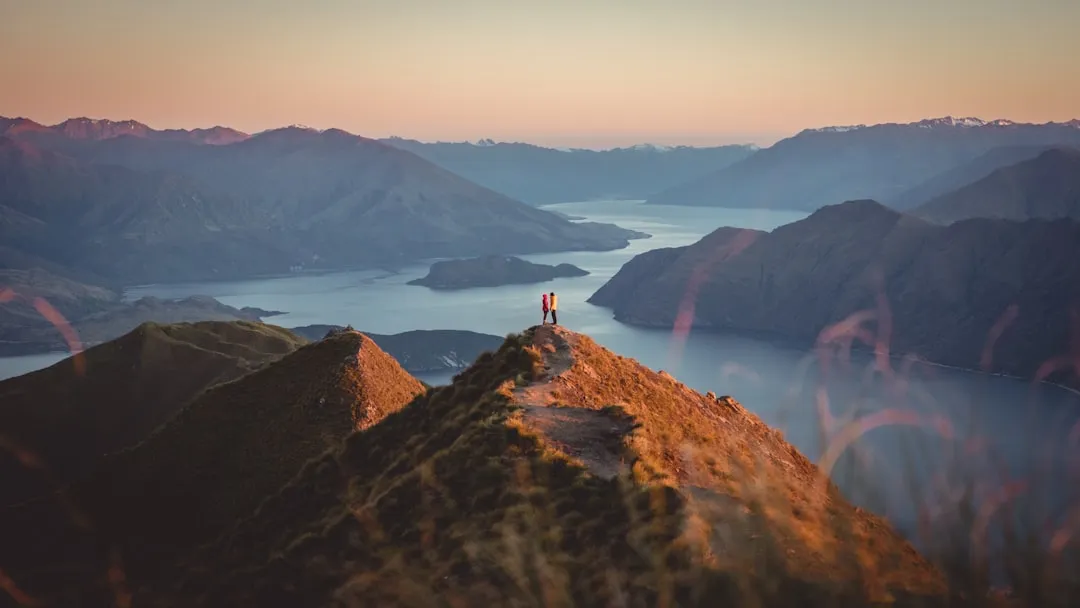
Roys Peak Track - The Iconic Vista of the Southern Alps
The Roys Peak Track is perhaps the most recognisable day hike in New Zealand, a 16-kilometre return journey that has become a global symbol of the country’s dramatic alpine beauty. Rising 1,228 metres from the shores of Lake Wanaka to the 1,578-metre summit of Mount Roy, this track offers a relentless but rewarding ascent through high-country tussock grasslands. Unlike many of New Zealand’s Great Walks that wind through dense podocarp forests, Roys Peak is characterised by its openness; from the very first step, hikers are treated to expanding views of the shimmering blue waters of Lake Wanaka, the jagged peaks of Mount Aspiring National Park, and the sprawling Matukituki Valley. It is a landscape of immense scale, where the sky feels vast and the mountains feel infinite.
While its fame on social media often precedes it, the reality of Roys Peak is a serious physical undertaking. It is not a casual stroll, but a steep, zig-zagging climb that tests the endurance of even fit hikers. The track follows a well-formed farm road across private land, specifically the Mount Roy Station, which remains an active sheep and cattle farm. This unique intersection of public recreation and private pastoralism defines the character of the walk. Hikers share the slopes with grazing livestock, navigating a series of switchbacks that seem to never end until the final, breathtaking ridge line is reached. Whether you are seeking the perfect photograph at the famous "lookout" or pushing for the true summit to stand amongst the clouds, Roys Peak provides a quintessential New Zealand mountain experience that stays with you long after the descent is finished.
- Distance: 16.0 km return
- Elevation Gain: 1,228 m
- Duration: 5–7 hours
- Difficulty: Challenging (due to steepness and exposure)
- Highest Point: 1,578 m (Summit)
- Best Time: October to April (Note: Closed for lambing 1 October – 10 November)
- Closest Town: Wanaka (6 km from trailhead)
Overview
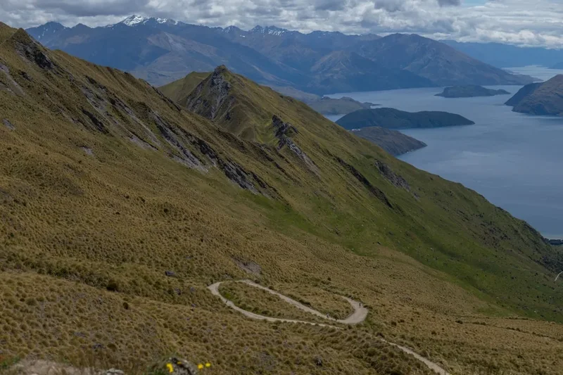
The Roys Peak Track is a masterclass in perspective. Located in the Otago region of the South Island, it serves as a natural amphitheatre overlooking the Southern Alps. The walk is defined by its consistency; there are no flat sections, no hidden valleys, and very little shade. It is a direct, honest climb from the car park at 350 metres above sea level to the summit at 1,578 metres. This lack of topographical variety is exactly what makes the views so spectacular—as you gain height, the horizon simply drops away, revealing more of the lake’s intricate shoreline, its islands (such as Mou Waho and Mou Tapu), and the snow-capped giants of the Tititea/Mount Aspiring massif in the distance.
The terrain is dominated by golden tussock (Chionochloa), a hardy native grass that ripples in the wind like a tawny sea. This open landscape means hikers are exposed to the elements throughout the entire duration of the walk. In the height of summer, the Otago sun can be fierce, reflecting off the dry earth and making the climb feel significantly more arduous. Conversely, the wind can whip across the exposed ridges with startling force, even on a seemingly calm day in Wanaka. The track itself is wide and gravelled, designed to accommodate the farm vehicles of Mount Roy Station, which makes for easy footing but does little to alleviate the strain on the calves during the ascent or the knees during the descent.
Most hikers aim for the famous "lookout" point, located about 1.5 kilometres before the actual summit. This narrow ridge provides the iconic "Instagram" shot where a lone hiker appears to stand on the edge of the world with Lake Wanaka far below. However, the true summit lies further up the ridge, marked by a transmitter station and a trig point. Reaching the very top provides a 360-degree panorama that includes the Clutha River, the Crown Range, and on exceptionally clear days, the distant peaks of the Remarkables near Queenstown. It is a journey of grit and determination, where the physical toll of the 1,228-metre climb is balanced by the sheer emotional impact of the scenery.
History and Cultural Context
The history of Roys Peak is inextricably linked to the pastoral development of the Otago region. The mountain is named after Captain William Roy, a pioneer who was involved in the early surveying of the district. For over a century, the land has been part of Mount Roy Station, a high-country run that has seen generations of farmers managing sheep and cattle on these steep, unforgiving slopes. The track hikers use today was originally carved out for farm management, allowing shepherds and vehicles to reach the higher altitude grazing lands. This agricultural heritage is still very much alive; the track is closed annually from the 1st of October to the 10th of November to allow for lambing, a critical period where the ewes require peace and isolation to ensure the survival of their young.
From a Māori perspective, the wider Wanaka region holds deep significance for Ngāi Tahu, the iwi (tribe) of the South Island. The name Wanaka is a corruption of Oanaka, meaning "The place of Anaka," a reference to an early ancestor. The lake and its surrounding mountains were traditional seasonal homes where Māori would travel to hunt moa, gather eels (tuna), and collect plant resources. The high peaks served as landmarks for navigation through the complex alpine passes. While Roys Peak itself may not have the same specific mythological status as some of the larger peaks like Tititea (Mount Aspiring), it forms part of the cultural landscape that Ngāi Tahu have traversed and named for centuries.
In recent decades, the history of Roys Peak has taken a modern turn. With the rise of digital photography and social media, the track transitioned from a local secret and a training ground for mountaineers into one of the most popular tourist destinations in New Zealand. This surge in popularity has brought challenges, including the need for expanded parking and improved waste management. The Department of Conservation (DOC) works closely with the landowners to maintain the balance between protecting the farming operation and providing public access to this world-class viewpoint. The track stands as a testament to the "freedom to roam" spirit of New Zealand, where private land can be shared for the benefit of all who respect the environment.
Want more background? Read extended notes on history and cultural context → Learn more
Seasonal Highlights and Weather Reality
The experience of Roys Peak changes dramatically with the seasons, and understanding these shifts is crucial for a safe and enjoyable hike. The "Great Walk" season logic doesn't strictly apply here as it is a day hike, but the weather patterns of the Southern Alps dictate the accessibility of the summit.
Summer (December to February): This is the most popular time to hike, characterised by long daylight hours and warm temperatures. However, summer brings the challenge of extreme heat. Because there is no forest cover, hikers are exposed to the sun for the entire 5–7 hours. Temperatures in Wanaka can exceed 30°C, and on the track, the heat is intensified by the lack of breeze in the lower zig-zags. Early morning starts (4:00 AM or 5:00 AM) are highly recommended to beat the heat and the crowds.
Autumn (March to May): Many locals consider this the best time for Roys Peak. The air is crisper, the light is softer for photography, and the temperatures are much more comfortable for a strenuous climb. The golden hues of the tussock are complemented by the changing colours of the trees in the Wanaka township below. Snow may begin to dust the summit in late May, adding a dramatic contrast to the blue of the lake.
Winter (June to August): In winter, Roys Peak becomes a serious alpine undertaking. The upper sections of the track are frequently covered in deep snow and ice. Hikers must be equipped with ice axes and crampons, and possess the knowledge of how to use them. Avalanche risk can be a factor on the steeper upper slopes after heavy snowfalls. The days are short, and temperatures at the summit can drop well below freezing with wind chill. Only experienced alpine hikers should attempt the summit in these conditions.
Spring (September to November): Spring is a time of transition. The snow begins to melt, often leaving the track muddy and slippery. CRITICAL NOTE: The track is closed every year from 1 October to 10 November for lambing. This closure is strictly enforced to protect the livestock on Mount Roy Station. If you are planning a trip during this window, you will need to look at alternative hikes like Isthmus Peak.
Recommended Itinerary

Roys Peak Day Hike Progression
Early Morning: The Lower Zig-Zags
- Distance: 0 km – 4 km
- Elevation Gain: ~400 m
- Time: 1 – 1.5 hours
- Start at the Roys Peak Track car park on Mount Aspiring Road.
- Cross the stile and begin the immediate ascent through the first series of wide switchbacks.
- The gradient is consistent and steep from the outset.
- Pass through active farm paddocks; keep a respectful distance from sheep and cattle.
- The views of Lake Wanaka begin to open up almost immediately, looking back toward the township.
Mid-Morning: The Conservation Area and Mid-Slope
- Distance: 4 km – 6.5 km
- Elevation Gain: ~450 m
- Time: 1 – 1.5 hours
- The track continues its relentless zig-zag pattern up the eastern face of the mountain.
- The vegetation shifts slightly as you gain altitude, with more prominent native tussock and fewer introduced grasses.
- This section is often the most mentally taxing, as the summit still looks far away and the car park is now a tiny speck below.
- Take regular breaks to hydrate; there is no water available on the mountain.
Midday: The Famous Lookout and Ridge Line
- Distance: 6.5 km – 7.2 km
- Elevation Gain: ~150 m
- Time: 30 – 45 minutes
- Reach the iconic "lookout" point. This is a flat, narrow ridge that juts out toward the lake.
- Expect a queue for photos during peak season; please be patient and respectful of others.
- This is a natural spot for a long break and lunch, offering the most famous view of the trip.
- Many hikers choose to end their journey here, but the true summit is still visible above.
Early Afternoon: The Final Push to the Summit
- Distance: 7.2 km – 8.0 km
- Elevation Gain: ~228 m
- Time: 45 minutes – 1 hour
- The track narrows slightly and follows the ridge line toward the summit.
- This section can be significantly windier and colder than the lower slopes.
- The final climb involves tighter zig-zags leading up to the transmitter station.
- At the summit (1,578 m), enjoy 360-degree views including Mount Aspiring/Tititea to the west and the Clutha River to the east.
Late Afternoon: The Descent
- Distance: 8.0 km – 16.0 km (Return)
- Elevation Loss: 1,228 m
- Time: 2 – 3 hours
- Retrace your steps down the same track.
- The descent is notoriously hard on the knees and toes; trekking poles are highly recommended.
- The afternoon sun can be particularly punishing on the descent as you are facing into the heat.
- Ensure you have saved enough water for the return journey.
Planning and Bookings
Book Your Trip
Everything you need to plan your journey
Accommodation
Find places to stay near Wanaka
Flights
Search flights to Wanaka
Essential Preparation
Preparation for Roys Peak focuses on physical fitness and timing. Because the track gains over 1,200 metres in just 8 kilometres, it requires a good level of cardiovascular endurance and leg strength. If you are not a regular hiker, consider doing some smaller hills in the days leading up to the climb. Logistics are relatively simple as the trailhead is only a 6-minute drive from the centre of Wanaka. However, the car park is small and fills up extremely early—often by 8:00 AM in summer. If the car park is full, do not park on the grass verges of the main road, as you will likely be fined or towed. Consider taking a shuttle from Wanaka or cycling to the trailhead if you aren't an early riser.
Wanaka is the perfect base for this hike, offering everything from luxury lodges to bustling backpacker hostels. The town has several outdoor equipment stores where you can hire trekking poles or buy last-minute supplies like high-SPF sunscreen and hydration bladders. There is no booking required for the track itself, but you must check the DOC website for any temporary closures due to weather or track maintenance.
Trail Accommodation
This is a day hike requiring no overnight accommodation on the mountain. Camping is strictly prohibited on the Roys Peak Track and within the Mount Roy Station boundaries. This is to protect the private land, the livestock, and the fragile alpine environment. There are no huts or shelters on the track. If you are looking for an overnight alpine experience in the area, you should look into the French Ridge Hut or Aspiring Hut in the nearby Mount Aspiring National Park, both of which require separate planning and bookings.
Required Gear
- Sturdy Footwear: Hiking boots with good grip and ankle support are ideal. While some people attempt this in trainers, the steep descent is much safer and more comfortable in dedicated hiking footwear.
- Layered Clothing: Even if it is hot in Wanaka, the summit can be 10°C colder and very windy. Bring a moisture-wicking base layer, a warm mid-layer (fleece or wool), and a windproof/waterproof outer shell.
- Sun Protection: This is non-negotiable. The New Zealand sun has very high UV levels. Bring a wide-brimmed hat, high-quality sunglasses, and SPF 50+ sunscreen.
- Trekking Poles: Highly recommended for the 1,228-metre descent to save your knees from significant impact.
- Head Torch: Essential if you are planning a sunrise or sunset hike. Do not rely on a phone torch, as the battery may die in the cold.
What to Bring
- Water: Bring at least 2–3 litres per person. There are NO water sources on the track, and the physical exertion combined with the sun makes dehydration a real risk.
- High-Energy Food: Bring plenty of snacks (nuts, chocolate, fruit) and a substantial lunch to enjoy at the lookout or summit. You will burn a significant amount of calories on the climb.
- First Aid Kit: Include blister plasters (moleskin or Compeed), as the long descent is a prime environment for hot spots on the toes and heels.
- Rubbish Bag: There are no bins on the track. Everything you take up must come back down with you.
- Fully Charged Phone/Camera: You will want to take many photos, but ensure you have enough battery left for emergencies. A portable power bank is a good idea.
Permits
No permits or fees are required to hike the Roys Peak Track. It is free for all members of the public to access. However, because the track crosses private land, access is a privilege granted by the landowners of Mount Roy Station. Hikers must respect the following rules to ensure this access remains open for the future:
- Lambing Closure: The track is closed from 1 October to 10 November every year. There are no exceptions to this rule.
- No Dogs: Dogs are strictly prohibited on the track at all times to protect the livestock.
- No Drones: The use of drones is not permitted on the Roys Peak Track without specific authorisation from the Department of Conservation and the landowner. This is to prevent disturbance to other hikers and the farm animals.
- Stay on the Track: Do not take shortcuts through the zig-zags. This causes significant soil erosion and damages the sensitive alpine grasses.
While there is no entry fee, there is a donation box at the start of the track. Contributions go toward the maintenance of the track and the facilities (such as the toilets at the car park and the mid-way point). If you have enjoyed the walk, a small donation is a great way to show appreciation for the upkeep of this world-class resource.
Other Activities in the Area
Wanaka is a hub for outdoor adventure and relaxation. After conquering Roys Peak, consider these other local experiences:
- That Wanaka Tree: Visit the most photographed tree in New Zealand, located at the southern end of Lake Wanaka. It is a short, flat walk from the town centre.
- Isthmus Peak: Often called the "better version" of Roys Peak by locals, this hike offers views of both Lake Wanaka and Lake Hawea. It is of similar difficulty but generally less crowded.
- Rob Roy Glacier Track: A spectacular half-day walk in Mount Aspiring National Park that leads you to the base of a hanging glacier, complete with waterfalls and alpine parrots (kea).
- Puzzling World: A great option for a rest day or a rainy day, featuring a massive 3D maze and various optical illusion rooms.
- Lake Wanaka Boat Tours: Take a boat to Mou Waho Island, a predator-free sanctuary where you can hike to a lake on an island in a lake.
- Wine Tasting: The Central Otago region is world-famous for its Pinot Noir. Visit Rippon Vineyard for some of the most scenic wine tasting in the world.
Safety and Conditions
The primary safety concerns on Roys Peak are exposure and physical exhaustion. Because the track is so accessible and popular, many hikers underestimate the mountain environment. It is essential to treat this hike with the same respect you would give a remote backcountry route.
Weather Awareness: The weather in the Southern Alps can change in minutes. A clear blue sky in the morning does not guarantee a safe afternoon. Check the MetService mountain forecast for "Southern Lakes" before you start. If clouds begin to build or the wind picks up significantly, be prepared to turn back. Hypothermia is a risk even in summer if you get wet and the wind chill factor is high.
Heat and Dehydration: This is the most common cause of distress on Roys Peak. The combination of steep climbing and direct sun can lead to heat exhaustion quickly. Drink water regularly, even if you don't feel thirsty, and use the few shaded spots (usually behind large rocks or the occasional small dip in the terrain) to rest and cool down.
The Descent: More injuries occur on the way down than on the way up. The constant braking motion required on the steep gravel track puts immense strain on the quadriceps and knees. Fatigue can lead to slips and twisted ankles. Take your time on the descent, use trekking poles, and ensure your boots are laced tightly to prevent your toes from hitting the front of your shoes.
Emergency Communication: Cell phone coverage is generally good along most of the Roys Peak Track due to its proximity to Wanaka and the transmitter at the summit. However, there are "dead zones" in some of the folds of the mountain. Always tell someone your intended return time before you set off.
Side Trips and Points of Interest
While Roys Peak is a linear track, there are a few specific points of interest that deserve extra attention during your hike:
The "Instagram" Lookout: Located at approximately 6.5 kilometres into the climb, this is the spot that made the mountain famous. It is a narrow spur of land that offers a perfectly framed view of the lake. On busy days, you may see a line of people waiting for their turn. If you don't want to wait, there are several other similar spurs slightly higher up that offer almost identical views without the crowd.
The True Summit: Many people stop at the lookout, thinking they have reached the top. The true summit is another 150–200 metres of vertical gain further up the ridge. The view from the very top is significantly different, as it opens up the vista to the north and west, revealing the deep valleys of the Matukituki and the high peaks of the Alps that are hidden from the lower lookout.
Mount Roy Transmitter: The summit is home to a large telecommunications array. While not aesthetically pleasing, it serves as a useful landmark during the climb. The area around the transmitter is the highest point and provides the best 360-degree views.
Hidden Waterfalls: After heavy rain, small temporary waterfalls can sometimes be seen in the gullies to the south of the track. These are rare due to the dry nature of the schist rock, but they add a touch of magic to the landscape when they appear.
Leave No Trace
Roys Peak is a high-use area, and its beauty depends entirely on the collective responsibility of every hiker. Because it is private farmland, the impact of rubbish and waste is even more sensitive. Following the Leave No Trace principles is essential for keeping this track open and beautiful.
- Plan Ahead and Prepare: Ensure you have enough water and the right gear so you don't end up in an emergency situation that requires rescue.
- Dispose of Waste Properly: There are toilets at the car park and one toilet located near the lookout point. Use them. If you are caught short between these points, ensure you are at least 50 metres from the track and bury any human waste deeply. Pack out all toilet paper and feminine hygiene products.
- Leave What You Find: Do not pick wildflowers or remove rocks. Leave the environment exactly as you found it for the next person to enjoy.
- Respect Wildlife and Farm Animals: Do not feed the birds, and give the sheep and cattle plenty of space. If animals are on the track, wait for them to move or walk slowly around them.
- Be Considerate of Others: Keep noise levels down. Many people hike Roys Peak for the sense of peace and solitude. If you are listening to music, use headphones. Yield to uphill hikers, as they are working harder than you are on the descent.