Routeburn Flats to Falls Walk
The Routeburn Flats to Falls walk is a spectacular day hike located in the Fiordland National Park, New Zealand. This trail offers a taste of the world-renowned Routeburn Track, showcasing the dramatic alpine scenery, lush rainforests, and powerful glacial rivers that define this region. It's an accessible yet rewarding experience, perfect for those who want to immerse themselves in the grandeur of Fiordland without committing to a multi-day trek. The walk follows the Routeburn River, gradually ascending through ancient beech forests before opening up to expansive valley views and the impressive Routeburn Falls.
- Distance: 18.0 km one-way
- Elevation Gain: 400 m
- Duration: 6-8 hours
- Difficulty: Moderate
- Season: October to April
- Closest City: Queenstown
- Trailhead Access: Routeburn Shelter car park
Overview
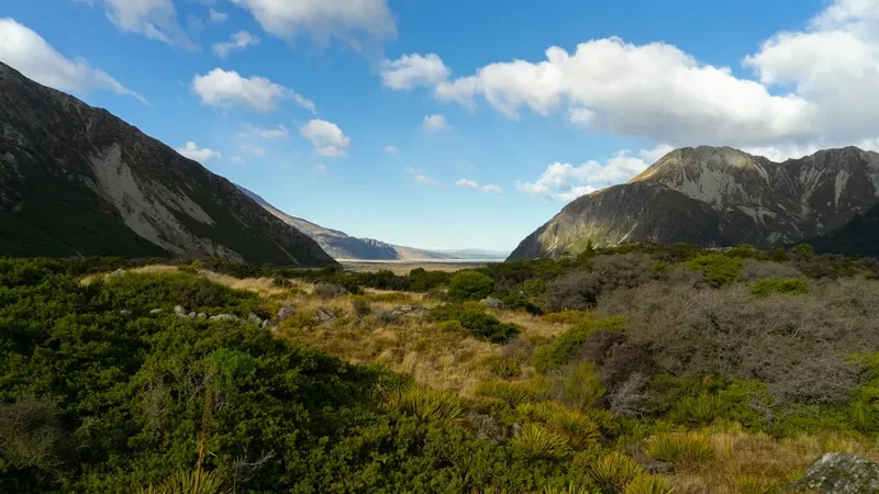
The Routeburn Flats to Falls walk is a segment of the iconic Routeburn Track, one of New Zealand's Great Walks. This day hike provides an excellent introduction to the Fiordland National Park's diverse landscapes. Starting from the Routeburn Shelter, the trail initially meanders through a mature beech forest, a cathedral of ancient trees draped in moss and ferns. The path is well-maintained and relatively gentle in the early stages, following the vibrant turquoise waters of the Routeburn River. As you progress, the forest canopy begins to thin, and the valley widens, revealing glimpses of the surrounding snow-capped peaks and the sheer scale of the glacial valley.
The first major landmark is Routeburn Flats, a broad, open area of tussock and river flats that offers stunning panoramic views. This is an ideal spot for a break, a picnic, and to soak in the alpine atmosphere. From Routeburn Flats, the trail continues its ascent, becoming steeper and more rugged as it approaches the Routeburn Falls. The final section involves a climb alongside the powerful cascades of the Routeburn River, culminating at the impressive Routeburn Falls themselves. Here, the river plunges over a series of rocky steps, creating a spectacular display of white water. The area around the falls is a natural amphitheatre, offering breathtaking views back down the valley and up towards the higher alpine regions.
This walk is classified as moderate due to its length and the sustained uphill gradient in the latter half. While no technical skills are required, good fitness is essential to comfortably complete the round trip within the estimated time. The trail is popular, especially during the peak season, so expect to encounter other walkers. However, the sheer size of the valley and the length of the walk mean that moments of solitude are still possible, particularly if you start early or finish later in the day.
History and Cultural Context
The Routeburn Valley, like much of Fiordland, has a rich history intertwined with both Māori and European exploration. For centuries, Māori, particularly Ngāi Tahu, traversed these valleys as part of seasonal routes, utilising the abundant natural resources and connecting different territories. The Routeburn Track itself was developed from traditional Māori trails, which were used for hunting, gathering, and travel between the Wakatipu Basin and the Fiordland coast.
European exploration in the area began in the mid-19th century with the discovery of gold in the nearby Shotover River. Prospectors and surveyors soon ventured into the surrounding mountains, including the Routeburn Valley. The development of the Routeburn Track as a formal hiking route gained momentum in the early 20th century. It was recognised as a significant scenic route, connecting the Wakatipu Basin with the Hollyford Valley and eventually leading towards Milford Sound. The track was gradually improved by the New Zealand Forest Service and later the Department of Conservation (DOC), becoming one of New Zealand's Great Walks in 1987.
The Routeburn Flats to Falls section represents a significant portion of the historic Routeburn Track, offering a tangible connection to the past. The well-maintained path, the remnants of old bridges, and the very existence of the track are testaments to the efforts of those who explored and developed this region. The valley's natural beauty has always been its primary draw, attracting adventurers, naturalists, and those seeking the profound peace of the wilderness. The cultural significance of the land to Ngāi Tahu remains, with the area being part of their ancestral territory, and the natural values of the region are recognised globally through its inclusion in the Te Wāhipounamu South West New Zealand World Heritage Area.
Seasonal Highlights and Weather Reality
The Routeburn Flats to Falls walk is best enjoyed during the warmer months, from October to April, which aligns with the Great Walks season. During this period, the weather is generally more stable, and the track is well-maintained by DOC rangers.
Spring (October–November): This is a beautiful time to visit, with snow still gracing the higher peaks and alpine wildflowers beginning to bloom. The rivers are often at their most vibrant turquoise due to snowmelt. However, weather can still be unpredictable, with occasional late snowfalls possible at higher elevations. Sandflies may start to become active.
Summer (December–February): The longest days and warmest temperatures make summer a popular choice. The forest is lush and green, and the river is at its most inviting for contemplation. However, summer also brings the highest numbers of sandflies, which can be a significant nuisance. Rainfall is still common, and sudden changes in weather are always a possibility in Fiordland.
Autumn (March–April): This season offers crisp, clear days and stunning autumnal colours in the beech forests. The sandfly population typically decreases, and the crowds thin out compared to mid-summer. The weather can be more settled, but the risk of early snow on higher sections increases towards the end of April.
Winter (May–September): While the Routeburn Flats to Falls walk can technically be attempted in winter, it is not recommended for casual day hikers. The track can be covered in snow and ice, particularly the higher sections. River crossings may be hazardous, and avalanche risk is present. Access to the Routeburn Shelter may also be affected by snow. This season requires advanced winter mountaineering skills, appropriate equipment, and a thorough understanding of avalanche hazards. DOC advises that the track is for experienced winter travellers only outside the Great Walks season.
Weather: Fiordland is renowned for its changeable weather. Even in summer, you can experience all four seasons in a single day. Expect rain, wind, and sunshine. Always be prepared for wet conditions, and check the mountain forecast before you set out.
Recommended Itinerary
Routeburn Flats to Falls Day Walk Itinerary
Early Morning (Approx. 8:00 AM - 9:00 AM): Departure from Queenstown/Glenorchy
- Travel from Queenstown to Glenorchy (approx. 45 minutes).
- Continue on the scenic Routeburn Road from Glenorchy to the Routeburn Shelter car park (approx. 30 minutes). The road is sealed and accessible by 2WD vehicles.
- Allow ample time for the journey, as the scenery is spectacular and you'll want to stop for photos.
Morning (Approx. 9:30 AM - 12:00 PM): Routeburn Shelter to Routeburn Flats
- Start your walk from the Routeburn Shelter.
- Distance: Approximately 6.5 km
- Elevation Gain: Minimal (gradual ascent)
- Time: 1.5–2 hours
- The trail begins by traversing through a beautiful, mature beech forest.
- Follow the well-marked path alongside the Routeburn River.
- Enjoy the sounds of the river and the dappled sunlight filtering through the trees.
- Arrive at Routeburn Flats, a wide, open area with stunning views of the surrounding mountains and the river.
- This is an excellent spot for a short break and to take in the expansive scenery.
Midday (Approx. 12:00 PM - 2:00 PM): Routeburn Flats to Routeburn Falls Hut
- Distance: Approximately 2.5 km
- Elevation Gain: Approximately 200 m
- Time: 1–1.5 hours
- Continue from Routeburn Flats, the track begins to climb more noticeably.
- The forest becomes denser, and the sound of the river grows louder as you approach the falls.
- The path becomes steeper and rockier in places.
- Arrive at Routeburn Falls Hut. This is the turnaround point for most day walkers.
Afternoon (Approx. 2:00 PM - 4:00 PM): Exploration and Return Journey Start
- Spend time exploring the area around Routeburn Falls.
- Enjoy the powerful cascades of the Routeburn River.
- Have your lunch or snacks with a spectacular view.
- Begin your descent back towards the Routeburn Shelter.
Late Afternoon (Approx. 4:00 PM - 6:00 PM): Routeburn Falls Hut to Routeburn Shelter
- Distance: Approximately 9.0 km
- Elevation Loss: Approximately 200 m
- Time: 2–3 hours
- The descent is generally quicker than the ascent.
- Take care on steeper or slippery sections.
- Enjoy the changing light and perspectives as you retrace your steps through the forest.
- Arrive back at the Routeburn Shelter car park.
Evening (Approx. 6:00 PM onwards): Return to Glenorchy/Queenstown
- Drive back to Glenorchy and then to Queenstown.
- Consider stopping in Glenorchy for dinner or refreshments.
Important Notes:
- This is a day walk; no overnight accommodation is required on the trail itself.
- The Routeburn Falls Hut is a backcountry hut for overnight stays for those hiking the full Routeburn Track. Day walkers should not occupy bunks.
- Carry sufficient water or a water filter, as water sources are plentiful but should be treated.
- Be prepared for all weather conditions.
- Sandflies can be prevalent, especially during warmer months.
Planning and Bookings
Book Your Trip
Everything you need to plan your journey
Accommodation
Find places to stay near Queenstown
Flights
Search flights to Queenstown
Essential Preparation
The Routeburn Flats to Falls walk is a day hike, meaning no overnight accommodation bookings are required on the trail itself. However, thorough preparation is still crucial for a safe and enjoyable experience. The closest major town and logistical hub is Queenstown, which offers a wide range of accommodation, dining, and outdoor gear shops. Glenorchy, a smaller settlement closer to the trailhead, also provides some accommodation and services.
Fitness: This is a moderate-difficulty walk, covering 18 km with a significant elevation gain of 400 metres. A reasonable level of fitness is required to complete the walk comfortably within the estimated 6-8 hours. Regular walking, hiking, or cardiovascular exercise in the weeks leading up to your trip will be beneficial. Be prepared for sustained uphill sections, particularly between Routeburn Flats and Routeburn Falls.
Logistics: Access to the Routeburn Shelter is via Routeburn Road, which is sealed and suitable for 2WD vehicles. Parking is available at the shelter. If you are not driving, shuttle services operate from Queenstown and Glenorchy to the Routeburn Shelter. It is advisable to book these services in advance, especially during peak season.
Base Town: Queenstown is the primary base for this walk. It offers a vast array of accommodation options, from budget-friendly hostels and motels to luxury hotels. Queenstown also has numerous outdoor gear stores where you can purchase or rent any last-minute equipment. Supermarkets are readily available for stocking up on food and supplies.
Trail Accommodation
This is a day hike requiring no overnight accommodation on the trail itself. The Routeburn Falls Hut is located approximately 9 km from the Routeburn Shelter and serves as a backcountry hut for those completing the multi-day Routeburn Track. Day walkers are welcome to use the hut's common areas for breaks and meals but should not occupy bunks. There are no campsites along this specific day walk section.
Required Gear
- Sturdy walking boots: Waterproof and with good ankle support. Ensure they are well broken-in to prevent blisters.
- Waterproof jacket: Essential for Fiordland's unpredictable weather. Look for Gore-Tex or similar breathable, waterproof material with taped seams.
- Waterproof overtrousers: To keep your lower body dry during rain showers.
- Warm layers: Including a fleece or wool mid-layer and a thermal base layer. Even in summer, temperatures can drop significantly, especially at higher elevations.
- Hat and gloves: For warmth and sun protection.
- Backpack: A comfortable day pack (20-30 litres) to carry your essentials.
- Navigation: While the track is well-marked, a map of the Routeburn Track and a compass or GPS device are recommended, especially if you are unfamiliar with the area. An offline map app on your phone is also useful.
- First-aid kit: Including blister treatment, pain relievers, bandages, and any personal medications.
- Head torch: With spare batteries, in case your walk takes longer than expected or you encounter unexpected delays.
What to Bring
- Food: Plenty of high-energy snacks and a packed lunch. There are no food services on the trail.
- Water: Carry at least 1.5-2 litres of water per person. Alternatively, bring a water filter or purification tablets, as the Routeburn River is a reliable water source, but it's always best to treat it.
- Sun protection: Sunscreen (SPF 30+), sunglasses, and a wide-brimmed hat. The sun can be intense, even on cloudy days, especially at higher altitudes.
- Insect repellent: Sandflies are prevalent in Fiordland, particularly during warmer months. A good quality repellent containing DEET is highly recommended.
- Toilet paper and a small trowel: For emergencies, though using the facilities at Routeburn Falls Hut is preferred. Pack out all used toilet paper.
- Hand sanitiser: For hygiene, especially before eating.
- Camera: To capture the stunning scenery.
- Walking poles: Optional, but can be helpful for stability on ascents and descents, and for reducing strain on knees.
- Small plastic bags: For packing out all rubbish, including food scraps and wrappers.
Permits
For the Routeburn Flats to Falls day walk, no specific permits or bookings are required. This section of the Routeburn Track is open to the public for day use without the need for advance reservations, unlike the multi-day Great Walks which have strict booking systems.
However, it is important to note that the Routeburn Track is a Great Walk, and during the Great Walks season (typically late October to late April), the huts along the full track require mandatory bookings. While you will not be staying overnight on this day walk, you will pass the Routeburn Falls Hut, and it's good to be aware of the booking requirements for those undertaking the longer journey.
Great Walks Season (Late October – Late April):
- Huts along the full Routeburn Track (including Routeburn Falls Hut) require advance booking through the Department of Conservation (DOC).
- These bookings are extremely popular and sell out months in advance.
- Day walkers do not need to book, but should be mindful of overnight hikers and their need for space and quiet in the huts.
Outside Great Walks Season (May – Late October):
- The track is open but unserviced. Huts are available on a first-come, first-served basis, but facilities are minimal.
- Winter conditions can make the track hazardous, requiring mountaineering experience and equipment.
- Day walkers should still exercise extreme caution and be fully prepared for winter conditions.
Parking: While no permit is required for parking at the Routeburn Shelter, it is advisable to arrive early, especially during peak season, as the car park can fill up quickly. There is no fee for parking.
General Advice: Always check the Department of Conservation (DOC) website for the latest track conditions, alerts, and any potential closures before you plan your trip. While this day walk is generally accessible, unforeseen events like extreme weather or track damage can occur.
Other Activities in the Area
The region surrounding the Routeburn Flats to Falls walk offers a wealth of activities for nature lovers and adventure seekers:
- Full Routeburn Track: For those inspired by this day walk, consider booking the full 3-day, 2-night Routeburn Track experience. This iconic Great Walk traverses from the Wakatipu Basin to the Hollyford Valley, offering unparalleled alpine and rainforest scenery.
- Glenorchy Walkways: Explore the numerous shorter walks around Glenorchy, such as the Glenorchy Lagoon Walkway, offering stunning views of Lake Wakatipu and the surrounding mountains.
- Lake Wakatipu Cruises: Take a scenic cruise on Lake Wakatipu from Queenstown, enjoying the majestic Remarkables mountain range and the crystal-clear waters.
- Jet Boating: Experience the thrill of jet boating on the Dart River or Shotover River, offering exhilarating rides through narrow canyons and braided river systems.
- Horse Riding: Explore the scenic landscapes around Glenorchy on horseback, with various operators offering guided rides through valleys and along riverbeds.
- Lord of the Rings Tours: Queenstown and Glenorchy are famous filming locations for "The Lord of the Rings" and "The Hobbit" trilogies. Numerous tours are available to visit these iconic sites.
- Queenstown Adventure Activities: As the adventure capital of New Zealand, Queenstown offers a vast array of activities including bungee jumping, skydiving, white-water rafting, canyoning, and mountain biking.
- Hiking in Fiordland National Park: Beyond the Routeburn, explore other day hikes or multi-day treks within Fiordland, such as parts of the Kepler Track or the Milford Track (requiring significant planning and booking).
Safety and Conditions
Weather Preparedness: Fiordland's weather is notoriously unpredictable. Be prepared for rain, wind, and temperature fluctuations, even during summer. Always check the MetService mountain forecast for the Routeburn area before you depart and be ready to turn back if conditions deteriorate.
Track Conditions: The Routeburn Flats to Falls section is generally well-maintained. However, after heavy rain, sections of the track can become slippery, muddy, or have increased water flow across small streams. The river crossings are bridged, but always exercise caution.
Fitness Level: This is a moderate walk. Ensure you have adequate fitness for an 18 km round trip with 400 metres of elevation gain. Pace yourself, take regular breaks, and do not push yourself beyond your limits.
Water Safety: While the Routeburn River is a source of water, it is essential to treat all water before drinking. Use a water filter, purification tablets, or boil the water. Be cautious around the riverbanks, especially near the falls, as the terrain can be steep and slippery.
Sandflies: Sandflies are a significant nuisance in Fiordland, especially during warmer months. They are most active at dawn and dusk and in damp, sheltered conditions. Wear long sleeves and trousers, use a strong insect repellent containing DEET, and consider a head net for maximum protection.
Navigation: The track is well-marked, but it is always wise to carry a map and compass or a GPS device. Familiarise yourself with the route before you start. Mobile phone reception is unreliable in the valley.
Emergency Contact: Inform someone of your hiking plans, including your intended route and expected return time. In case of an emergency, contact the Department of Conservation (DOC) or emergency services. Consider carrying a personal locator beacon (PLB) for remote areas.
Respect Wildlife: Do not feed native birds or animals. Keep a safe distance and observe them from afar.
Side Trips and Points of Interest
Routeburn Falls: The primary destination for this day walk. The powerful cascades of the Routeburn River plunging over a series of rocky steps create a spectacular natural amphitheatre. This is an ideal spot for a picnic lunch and to appreciate the raw power of glacial meltwater.
Routeburn Flats: Located approximately 6.5 km from the Routeburn Shelter, this is a broad, open area of tussock and river flats. It offers expansive panoramic views of the Routeburn Valley, including the surrounding alpine peaks and the winding river. It's a perfect spot for a rest stop, photography, and to appreciate the scale of the landscape.
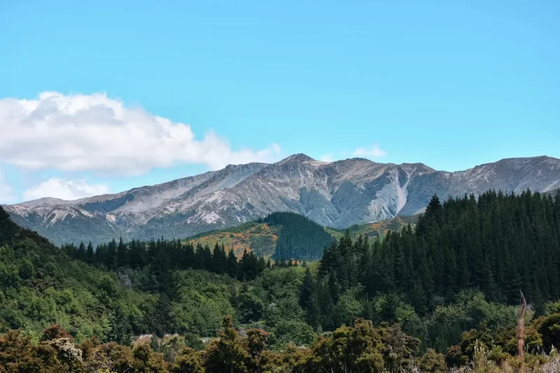
Beech Forest: The entire walk, particularly the initial section, passes through a magnificent ancient beech forest. These forests are characterised by their tall, straight trees, often draped in mosses and lichens, creating a mystical and serene atmosphere. Keep an eye out for native birdlife such as the bellbird, tūī, and fantail.
Routeburn River: The vibrant turquoise colour of the Routeburn River is a constant companion on this walk. Its colour is due to fine glacial rock flour suspended in the water. The river's journey from the high alpine regions to Lake Wakatipu is a defining feature of the landscape.
Routeburn Falls Hut: While primarily for overnight hikers, the hut area provides a good vantage point and a place to rest. It's a testament to the backcountry infrastructure that supports the Great Walks system.
Leave No Trace

The Routeburn Flats to Falls walk traverses a pristine natural environment within Fiordland National Park, a UNESCO World Heritage Area. Adhering to Leave No Trace principles is paramount to preserving this fragile ecosystem for future generations.
Plan Ahead and Prepare: Research the trail, check weather forecasts, and be prepared for all conditions. Carry appropriate gear and sufficient food and water.
Travel and Camp on Durable Surfaces: Stick to the marked track at all times. Avoid walking on vegetation, especially the delicate mosses and lichens that are easily damaged and take a long time to recover. The track is designed to withstand foot traffic; straying from it causes erosion and habitat destruction.
Dispose of Waste Properly: Pack out everything you pack in. This includes all food scraps, wrappers, and any other rubbish. Use the toilet facilities at Routeburn Falls Hut. If caught short, dig a cathole at least 10 metres away from water sources, trails, and campsites, and bury human waste. Pack out used toilet paper.
Leave What You Find: Do not remove any natural objects, such as rocks, plants, or flowers. Take only photographs and memories.
Minimise Campfire Impacts: Campfires are not permitted on this day walk. Even if they were, they are generally discouraged in New Zealand's backcountry to protect the environment.
Respect Wildlife: Observe wildlife from a distance. Never feed native animals, as it can disrupt their natural behaviours and diets, and can be harmful to their health. Keep pets under control if they are permitted (though they are generally not allowed on Great Walks).
Be Considerate of Other Visitors: Keep noise levels down, yield to uphill walkers, and be courteous to fellow hikers. The aim is to enjoy the natural environment without disturbing others.