
Route des Grandes Alpes - The Great Alpine Crossing
The Route des Grandes Alpes is one of the world’s most legendary long-distance journeys, a 684-kilometre odyssey that traverses the entire spine of the French Alps. Stretching from the temperate, crystal-clear shores of Lac Léman (Lake Geneva) in the north to the sun-drenched Mediterranean coast of Menton in the south, this route represents the ultimate alpine challenge. While traditionally celebrated as a premier driving and cycling itinerary, the walking corridor following this route—often intersecting with the iconic GR5 trail—offers an unparalleled immersion into the diverse landscapes, cultures, and ecosystems of the European high country. Over the course of 7 to 14 days, depending on the mode of travel and pace, adventurers ascend over 15,700 metres of cumulative elevation, crossing 17 major mountain passes, including the highest paved pass in the Alps, the Col de l'Iseran.
This journey is more than a mere physical feat; it is a transition through the very soul of France. It begins in the lush, green pastures of the Chablais and the Haute-Savoie, moves through the rugged, glaciated heart of the Vanoise and the Écrins, and eventually descends into the scorched, lavender-scented hills of Provence and the Alpes-Maritimes. Walkers will experience the dramatic shift from traditional wooden chalets and rich Beaufort cheese to the stone-built villages and olive groves of the south. It is a route of staggering scale, demanding high levels of fitness and a deep respect for the volatile mountain environment, but rewarding the persistent with some of the most magnificent panoramas on the continent.
- Distance: 684.0 km
- Duration: 7–14 days (highly dependent on pace and use of transport)
- Season: June to October (subject to snow levels on high passes)
- Highest point: Col de l'Iseran (2,770 m)
- Total Elevation Gain: 15,700 m
- Start: Thonon-les-Bains (Lake Geneva)
- Finish: Menton (Mediterranean Sea)
- Difficulty: Challenging (requires significant endurance and alpine experience)
Overview
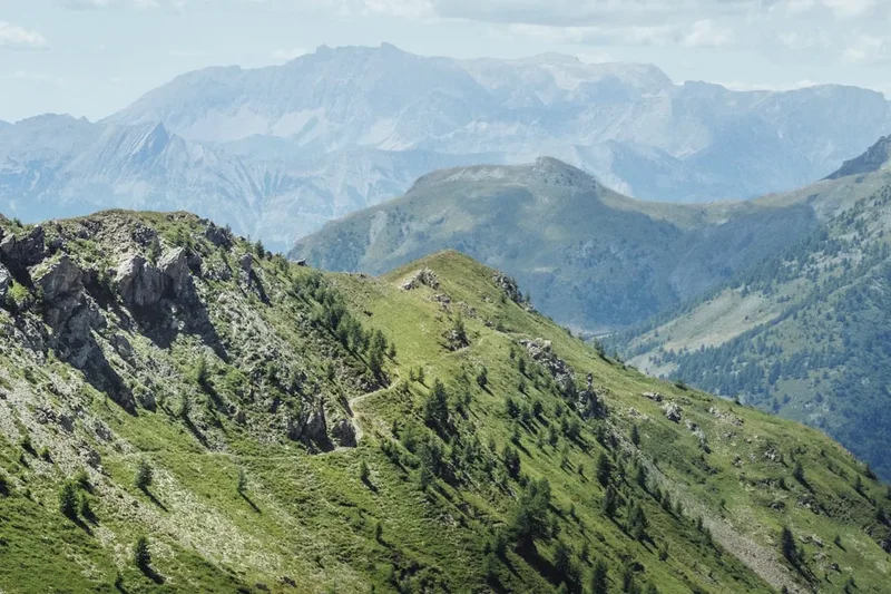
The Route des Grandes Alpes is a masterclass in geographical diversity. To walk this route is to witness the slow-motion collision of tectonic plates and the subsequent carving of the landscape by ancient glaciers. The journey is defined by its "cols"—the high mountain passes that serve as the only gateways between isolated valleys. Each col represents a milestone, a hard-won summit followed by a long, knee-jarring descent into a new world with its own dialect, architecture, and culinary traditions. The route is not a single, narrow path but a corridor of adventure that links the most prestigious massifs of the French Alps: the Chablais, the Mont Blanc massif, the Beaufortain, the Vanoise, the Queyras, the Ubaye, and finally the Mercantour.
The northern section is characterised by its verdant beauty. Starting at Thonon-les-Bains, the trail climbs through the pre-Alps, where the air is cool and the slopes are dotted with Abondance cattle. As you move south, the landscape becomes increasingly vertical and austere. The crossing of the Col de l'Iseran at 2,770 metres marks a significant transition into the high-altitude wilderness of the Vanoise National Park, where ibex and chamois are more common than humans. Further south, the Galibier and Izoard passes offer a lunar-like landscape of scree and jagged rock, famously immortalised by the Tour de France. The final stages are a sensory delight, as the crisp alpine air begins to carry the warmth of the Mediterranean, and the rugged peaks eventually give way to the azure horizon of the Côte d'Azur.
Logistically, the Route des Grandes Alpes is a feat of engineering and planning. While the road itself is a marvel, hikers often utilise the network of "Grand Randonnée" (GR) paths that parallel the route to avoid tarmac where possible. This allows for a more intimate connection with the wilderness while still hitting the iconic landmarks of the historic route. Whether staying in high-altitude refuges, local gîtes, or mountain hotels, the infrastructure along the way is well-developed, though it requires careful coordination. This is a journey for those who seek to understand the Alps in their entirety—not just as a series of peaks, but as a living, breathing cultural landscape that has been shaped by centuries of transhumance, trade, and mountain warfare.
History and Cultural Context
The Route des Grandes Alpes was not born of a single explorer’s vision, but rather as a strategic and touristic project initiated by the Touring Club de France in the early 20th century. In 1911, the project was officially launched with the goal of linking the various valleys of the Alps, which were previously isolated from one another, to create a continuous route from the lake to the sea. At the time, many of the high passes were only accessible via mule tracks or narrow military roads. The construction was a monumental task, involving thousands of workers who laboured in extreme conditions to carve roads into sheer cliff faces and over high-altitude saddles. The route was finally completed in 1937 with the opening of the Col de l'Iseran, inaugurated by the French President Albert Lebrun.
Historically, these mountains have always been a place of passage and conflict. The route crosses through territories that have seen the march of Roman legions, the strategic manoeuvres of Napoleon’s armies, and the fierce resistance of the Maquis during World War II. Many of the passes, such as the Col de l'Izoard and the Col de Tende, are overlooked by formidable stone forts, silent sentinels of a time when these borders were heavily contested between France and the House of Savoy or the Kingdom of Italy. Walking the route today, one cannot help but feel the weight of this history, as the path winds past abandoned barracks and memorials to those who lived and died in these high places.
Culturally, the route is a tapestry of alpine identities. In the north, the influence of the Duchy of Savoy is evident in the baroque churches and the hearty, cheese-based cuisine. As you cross into the southern Alps, the atmosphere shifts. The Queyras region, for instance, remained isolated for centuries, developing a unique culture of woodcarving and communal living. Further south, the Provençal influence becomes dominant, reflected in the use of stone in construction and the appearance of sundials on village walls. The Route des Grandes Alpes is a journey through these shifting identities, offering a profound insight into how mountain communities have adapted to their environment over a millennium.
Want more background? Read extended notes on history and cultural context → Learn more
Seasonal Highlights and Weather Reality
The window for completing the Route des Grandes Alpes is relatively narrow, dictated by the heavy snowfall that blankets the high passes for much of the year. The official season typically runs from mid-June to early October. Outside of this period, many of the highest cols, such as the Iseran and the Galibier, are blocked by snow, and the mountain refuges are closed or unstaffed. Even within the summer season, weather in the Alps is notoriously fickle and can change from brilliant sunshine to a violent thunderstorm or even a snow squall within an hour.
Early summer (June to July) is perhaps the most beautiful time to visit. The alpine meadows are in full bloom, creating a vibrant carpet of wildflowers, and the waterfalls are at their most powerful as the winter snow melts. However, hikers should be prepared for lingering snow patches on north-facing slopes above 2,200 metres, which may require the use of trekking poles or even micro-spikes. July and August are the warmest months and offer the most stable weather, but they also coincide with the peak tourist season and the Tour de France, meaning the roads and villages can be crowded.
Late summer and early autumn (September to October) offer a different kind of magic. The air becomes crisp and exceptionally clear, providing the best visibility for long-range views of Mont Blanc and the Écrins. The crowds thin out, and the larch forests in the southern Alps begin to turn a brilliant gold. The main risk during this period is the arrival of the first autumn storms, which can bring significant snowfall to the high passes, potentially ending the hiking season abruptly. Regardless of the month, walkers must be equipped for all conditions, as temperatures at the top of a 2,700-metre pass can be near freezing even in the height of summer.
Recommended Itinerary
14-Day Route des Grandes Alpes Walking Itinerary
Day 1: Thonon-les-Bains to Morzine
- Distance: 35 km
- Elevation gain: 1,200 m
- Time: 8–10 hours
- Start at the shores of Lac Léman (Lake Geneva)
- Climb through the rolling hills of the Chablais
- Pass through the Gorges du Pont du Diable
- Arrive in the alpine resort of Morzine
- A long opening day to establish a rhythm and leave the lakeside humidity behind
Day 2: Morzine to Cluses
- Distance: 30 km
- Elevation gain: 900 m
- Time: 7–9 hours
- Cross the Col des Gets (1,170 m)
- Descend into the Taninges valley
- Follow the Arve river towards Cluses
- Views of the Aravis range begin to appear to the south
Day 3: Cluses to Beaufort
- Distance: 45 km (Consider local transport for valley sections)
- Elevation gain: 1,500 m
- Time: 10–12 hours
- Cross the Col de la Colombière (1,613 m)
- Traverse the Aravis range via the Col des Aravis (1,487 m)
- Descend into the heart of the Beaufortain, famous for its cheese
- Arrive in the picturesque village of Beaufort
Day 4: Beaufort to Bourg-Saint-Maurice
- Distance: 40 km
- Elevation gain: 1,300 m
- Time: 9–11 hours
- Climb to the Cormet de Roselend (1,968 m)
- Pass the stunning turquoise waters of the Lac de Roselend
- Long descent into the Tarentaise Valley
- Stay in Bourg-Saint-Maurice, a major alpine hub
Day 5: Bourg-Saint-Maurice to Val d'Isère
- Distance: 32 km
- Elevation gain: 1,100 m
- Time: 8–10 hours
- Follow the Isère river upstream
- Pass through the village of Sainte-Foy-Tarentaise
- Steep climb into the high-altitude bowl of Val d'Isère
- Prepare for the highest pass of the trip the following day
Day 6: Val d'Isère to Lanslebourg-Mont-Cenis
- Distance: 38 km
- Elevation gain: 1,000 m
- Time: 9–11 hours
- Ascend the Col de l'Iseran (2,770 m), the highest point of the route
- Enter the Maurienne Valley and the Vanoise National Park
- Descend through the rugged high-alpine terrain to Lanslebourg
- Spectacular views of the glaciers of the Vanoise
Day 7: Lanslebourg to Saint-Michel-de-Maurienne
- Distance: 42 km
- Elevation gain: 600 m
- Time: 9–11 hours
- Follow the Arc river down the Maurienne Valley
- Pass through historic villages like Termignon and Modane
- Relatively flat day but high mileage
- Rest and resupply in Saint-Michel
Day 8: Saint-Michel-de-Maurienne to Briançon
- Distance: 48 km (High intensity; transport recommended for the Col du Télégraphe)
- Elevation gain: 1,800 m
- Time: 11–13 hours
- Cross the Col du Télégraphe (1,566 m) and the legendary Col du Galibier (2,642 m)
- Cross the Col du Lautaret (2,058 m)
- Long descent into the Guisane valley
- Arrive in the UNESCO-listed fortified city of Briançon
Day 9: Briançon to Guillestre
- Distance: 35 km
- Elevation gain: 1,200 m
- Time: 8–10 hours
- Ascend the Col d'Izoard (2,360 m)
- Pass through the "Casse Déserte," a surreal lunar landscape
- Descend into the Queyras region
- Arrive in Guillestre, the gateway to the southern Alps
Day 10: Guillestre to Barcelonnette
- Distance: 45 km
- Elevation gain: 1,100 m
- Time: 10–12 hours
- Cross the Col de Vars (2,108 m)
- Enter the Ubaye Valley
- Arrive in Barcelonnette, known for its "Mexican" villas
- The landscape begins to feel noticeably more Mediterranean
Day 11: Barcelonnette to Saint-Étienne-de-Tinée
- Distance: 42 km
- Elevation gain: 1,600 m
- Time: 10–12 hours
- Ascend the Col de la Bonette (2,715 m), one of the highest roads in Europe
- Enter the Mercantour National Park
- Descend into the Tinée Valley
- Stay in the traditional village of Saint-Étienne-de-Tinée
Day 12: Saint-Étienne-de-Tinée to Valdeblore
- Distance: 35 km
- Elevation gain: 1,000 m
- Time: 8–10 hours
- Cross the Col de la Couillole (1,678 m)
- Pass through the red-rock gorges of the Cians and Daluis nearby
- Arrive in the Valdeblore area, a transition between high peaks and coastal hills
Day 13: Valdeblore to Sospel
- Distance: 48 km (Consider splitting or using local shuttles)
- Elevation gain: 1,400 m
- Time: 11–13 hours
- Cross the Col de Turini (1,607 m), famous for the Monte Carlo Rally
- Descend through dense forests into the Bévéra Valley
- Arrive in the beautiful medieval town of Sospel
Day 14: Sospel to Menton
- Distance: 25 km
- Elevation gain: 600 m
- Time: 6–7 hours
- Final climb over the Col de Castillon (706 m)
- First views of the Mediterranean Sea
- Long descent into the gardens and lemon groves of Menton
- Finish at the beach for a celebratory dip in the sea
Important Notes:
- The distances listed are based on the road route; hiking the GR5 or alternative trails will vary the distance and elevation significantly.
- Many walkers choose to complete the route in 3–4 weeks to allow for a more manageable daily pace of 20–25 km.
- Public transport (buses and trains) is available in many valleys to skip less scenic road sections.
- Accommodation should be booked in advance, especially in July and August.
Planning and Bookings
Book Your Trip
Everything you need to plan your journey
Accommodation
Find places to stay near Thonon-les-Bains
Flights
Search flights to Thonon-les-Bains
Essential Preparation
Planning a journey of this magnitude requires meticulous organisation. The Route des Grandes Alpes is not a wilderness trail in the purest sense; it is a journey through a populated mountain range. This means that while you are rarely more than a day's walk from a village, you must coordinate your stops with available accommodation. Fitness is the most critical preparation. You will be walking for consecutive days with significant elevation changes. Training should focus on long-distance endurance and, crucially, downhill walking to prepare your knees for the thousands of metres of descent.
Logistically, Thonon-les-Bains is easily accessible via Geneva Airport (GVA), followed by a train or bus. Menton, at the finish, is well-connected by rail to Nice and its international airport. If you are planning to walk the entire route, consider how you will handle your luggage. Several companies offer luggage transfer services between hotels and gîtes, which can significantly increase your enjoyment of the trail by allowing you to carry only a day pack.
Trail Accommodation
The accommodation along the Route des Grandes Alpes is diverse, ranging from high-altitude mountain refuges (refuges de montagne) to valley gîtes, hotels, and campsites. In the high sections, such as the Vanoise or Mercantour, you may stay in traditional refuges managed by the Club Alpin Français (CAF) or private owners.
Accommodation Types:
- Refuges: Dormitory-style sleeping with shared facilities. Usually provide dinner and breakfast (half-board). Booking is essential. Costs range from €50 to €80 for half-board.
- Gîtes d'Étape: Specifically designed for hikers, these offer dorms or small rooms and are often located in villages. They are generally more comfortable than high-altitude refuges.
- Hotels: Available in larger towns like Morzine, Bourg-Saint-Maurice, Briançon, and Barcelonnette. These offer full amenities but at a higher price point.
- Camping: Numerous campsites exist in the valleys. Wild camping (bivouacking) is generally permitted in the French Alps above the treeline, but strict rules apply within National Parks (Vanoise, Écrins, Mercantour), where it is often only allowed between 7:00 PM and 9:00 AM and must be a certain distance from park boundaries or refuges.
What's Provided: Most refuges and gîtes provide blankets or duvets, but you are required to bring a silk or cotton sleeping bag liner (sac à viande). Meals are usually hearty and communal. What's NOT Provided: Towels, toiletries, and often electricity for charging devices (though this is changing). WiFi is rare in high-altitude spots.
Required Gear
- Footwear: High-quality, waterproof trekking boots with good ankle support. Ensure they are thoroughly broken in before starting.
- Clothing: A versatile layering system. Include moisture-wicking base layers, an insulating mid-layer (fleece or down), and a high-quality waterproof and windproof outer shell (Gore-Tex or similar).
- Backpack: A 35–50L pack if staying in accommodation; 60L+ if carrying camping gear. A rain cover is essential.
- Navigation: Topographic maps (IGN 1:25,000 are the gold standard), a compass, and a GPS device or smartphone with offline maps (e.g., Outdooractive or Komoot).
- Trekking Poles: Highly recommended to save your knees on the long descents and provide stability on uneven terrain.
- Safety Gear: A basic first aid kit, emergency whistle, and a space blanket.
What to Bring
- Water Treatment: While tap water in villages is safe, stream water should be treated with a filter or purification tablets due to livestock presence.
- Sun Protection: High-SPF sunscreen, lip balm with UV protection, sunglasses (Category 3 or 4), and a wide-brimmed hat. The alpine sun is exceptionally strong.
- Personal Items: Lightweight travel towel, biodegradable soap/shampoo, and a small repair kit for gear.
- Food/Snacks: While you can buy food in villages, always carry a day's worth of high-energy snacks (nuts, dried fruit, chocolate) for the high passes.
- Cash: Many remote refuges and small village shops do not accept credit cards. Carry enough Euros to cover several days of expenses.
- Power Bank: To keep your phone and GPS charged, as power outlets can be scarce in older refuges.
Permits
One of the great advantages of the Route des Grandes Alpes is that no overarching permit is required to walk the route. Access to the mountains in France is generally free and open to the public. However, there are specific regulations you must be aware of when passing through National Parks and protected areas.
National Park Regulations:
- Vanoise, Écrins, and Mercantour: These are highly protected areas. While no entry permit is needed, you must adhere to strict rules: no dogs (even on a leash), no mountain biking on certain trails, no fires, and no littering. Bivouacking (temporary camping) is strictly regulated—usually only allowed between 7:00 PM and 9:00 AM and at least an hour's walk from the park boundaries or road access.
- Nature Reserves: Areas like the Contamines-Montjoie or the Hauts de Villaroger may have additional seasonal restrictions to protect nesting birds or calving wildlife. Always check local signage.
Accommodation Bookings: While not a "permit" in the legal sense, your refuge bookings act as your de facto permit for staying overnight in the high mountains. During the peak months of July and August, the most popular refuges can be fully booked months in advance. It is highly recommended to secure your bed nights as soon as your itinerary is finalised.
Fishing and Hunting: If you plan to fish in alpine lakes or rivers, you must purchase a departmental fishing permit (carte de pêche), which can often be bought online or in local tobacco shops (Tabacs).
Other Activities in the Area
The Route des Grandes Alpes passes through some of Europe’s most famous outdoor playgrounds. Consider adding a few days to your trip to experience these highlights:
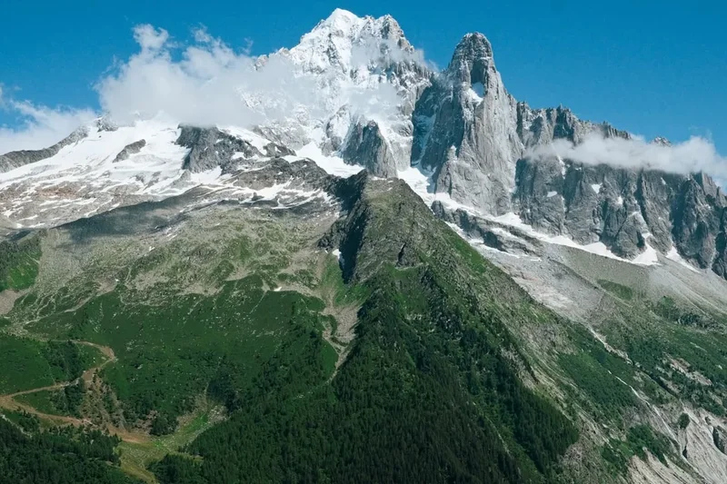
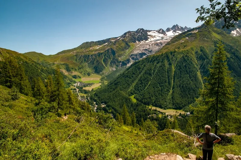
- Chamonix-Mont-Blanc: A short detour from the main route, Chamonix is the world capital of mountaineering. Take the Aiguille du Midi cable car to 3,842 metres for a close-up view of Mont Blanc, or visit the Mer de Glace glacier.
- Annecy: Known as the "Venice of the Alps," this stunning lakeside town is perfect for a rest day. Rent a bike to cycle around the lake or enjoy a swim in its famously clean waters.
- Via Ferrata: The French Alps are home to hundreds of "iron ways"—protected climbing routes. Notable ones can be found near Morzine, Briançon, and in the Maurienne Valley.
- Paragliding: Experience the Alps from the air. Tandem flights are available in almost every major resort along the route, with Saint-Hilaire and Annecy being world-renowned spots.
- Canyoning: The southern section of the route, particularly near the Mercantour and Sospel, offers some of the best canyoning in Europe in the turquoise waters of the Alpes-Maritimes.
- Fortress Tours: Explore the Vauban fortifications in Briançon (a UNESCO World Heritage site) or the massive Forts de l'Esseillon in the Maurienne Valley.
Safety and Conditions
Mountain Weather: The primary safety concern in the Alps is the weather. Storms can develop rapidly in the afternoon, bringing lightning, heavy rain, and a sudden drop in temperature. Always aim to cross high passes before midday. If you hear thunder, descend immediately from ridges and open slopes. Check the "Météo France" mountain forecast daily; it is highly accurate and provides specific data for different massifs.
Terrain Hazards: While the Route des Grandes Alpes follows established paths and roads, the terrain is steep. Rockfall is a risk in narrow valleys and beneath limestone cliffs, especially after heavy rain. Snow patches can persist well into July on high passes; crossing these requires care, as a slip can lead to a long slide. Trekking poles are invaluable for maintaining balance on loose scree.
Altitude: While not high enough to cause severe altitude sickness for most, you will be spending significant time above 2,000 metres. Stay hydrated, as the dry mountain air and physical exertion can lead to rapid dehydration. Be aware of the symptoms of mild altitude sickness, such as headaches or nausea, and descend if they persist.
Road Safety: Because the Route des Grandes Alpes is a famous driving and cycling route, you will frequently encounter traffic, especially on the cols. Cyclists often descend at high speeds, and motorcycles are common. When walking on road sections, always walk facing oncoming traffic and stay as far to the side as possible. Use high-visibility gear if walking in low light or fog.
Emergency Services: The universal emergency number in France (and the EU) is 112. Mountain rescue (PGHM - Peloton de Gendarmerie de Haute Montagne) is highly professional but should only be called in genuine emergencies. Ensure your travel insurance specifically covers mountain rescue and repatriation.
Side Trips and Points of Interest
The Casse Déserte (Col d'Izoard): Located just below the summit of the Col d'Izoard, this is one of the most iconic landscapes in the Alps. It is a vast, sloping field of scree punctuated by jagged, ochre-coloured rock pinnacles. The lack of vegetation and the stark contrast between the blue sky and the orange rock make it feel like another planet. A memorial to cycling legends Fausto Coppi and Louison Bobet is located here.
Cime de la Bonette: While the Col de la Bonette is the pass, a short loop road (and a walking path) continues up to the Cime de la Bonette at 2,860 metres. From the orientation table at the top, you have a 360-degree view that, on a clear day, stretches from the glaciers of the Écrins to the Mediterranean Sea. It is a breathtaking perspective on the entire southern alpine chain.
The Forts of the Maurienne: Near Modane, the five Forts de l'Esseillon are perched on a cliff edge overlooking a deep gorge. These 19th-century Sardinian fortifications were built to protect against a French invasion. Today, they are connected by a series of walking trails and a spectacular via ferrata that crosses the gorge via a suspension bridge.
Lac de Roselend: Often cited as the most beautiful reservoir in the Alps, the Lac de Roselend is a shimmering turquoise gem surrounded by the green pastures of the Beaufortain. The small Chapel of Roselend, saved from the rising waters when the dam was built, sits on the shore and provides a perfect spot for reflection.
Vallée des Merveilles: Located in the heart of the Mercantour National Park, this "Valley of Wonders" contains over 40,000 prehistoric rock engravings dating back to the Bronze Age. Access to the engravings is strictly regulated, and it is best visited with a certified guide, but the landscape of glaciated rock and high-altitude lakes is spectacular in its own right.
Leave No Trace
The French Alps are a fragile ecosystem under increasing pressure from climate change and tourism. As a walker on the Route des Grandes Alpes, you have a responsibility to minimise your impact on this magnificent landscape. The principles of Leave No Trace are essential for preserving the purity of the mountains for future generations.
Respecting the Environment:
- Waste Management: Pack out everything you pack in. This includes organic waste like orange peels or banana skins, which decompose very slowly at high altitudes and can be harmful to local wildlife.
- Water Protection: Do not use soap or detergent directly in alpine lakes or streams. Even biodegradable soap can disrupt the delicate chemical balance of high-altitude water sources. Wash at least 60 metres away from water.
- Stay on the Path: In alpine meadows, the soil is thin and vegetation is slow-growing. Short-cutting switchbacks causes erosion and destroys the very beauty you came to see.
- Wildlife: Observe animals from a distance. The marmots, ibex, and chamois of the Alps need to conserve energy for the harsh winter; being chased or disturbed by humans (or dogs) can be life-threatening for them.
- Flora: Many alpine flowers, such as the Edelweiss or the Genepi, are protected by law. Take photos, but never pick the flowers.
- Bivouacking: If you camp, choose a site that is already impacted or on a durable surface like rock or gravel. Avoid camping on fragile alpine grass.
By following these principles, you ensure that the "Great Alpine Crossing" remains a pristine wilderness experience. The goal is to leave the mountains exactly as you found them—or better.