Rota Vicentina (Fishermen's Trail)
The Rota Vicentina, a network of walking trails along the southwestern coast of Portugal, offers a breathtaking journey through some of Europe's most pristine coastal landscapes. The Fishermen's Trail (Trilho dos Pescadores) is its most celebrated section, a 75 km route that winds along dramatic cliffs, through fragrant pine forests, and across secluded sandy beaches. This trail is a testament to the raw beauty of the Alentejo and Vicentine Coast Natural Park, a protected area renowned for its biodiversity, stunning geological formations, and rich cultural heritage. Designed to follow the coastline as closely as possible, the Fishermen's Trail is a challenging yet immensely rewarding experience, offering a unique perspective on the Atlantic Ocean and the traditional livelihoods of the coastal communities.
- Distance: 75.0 km one-way
- Duration: 4–5 days
- Season: September to June (avoiding the hot summer months)
- Difficulty: Moderate to Challenging (due to sandy terrain and coastal paths)
- Highest point: Coastal cliffs (variable, generally low elevation gain but significant ups and downs)
- Daily walkers: No daily limit, but recommended to book accommodation in advance
- Direction: South to North (Porto Covo to Sagres) or North to South (Sagres to Porto Covo)
Overview
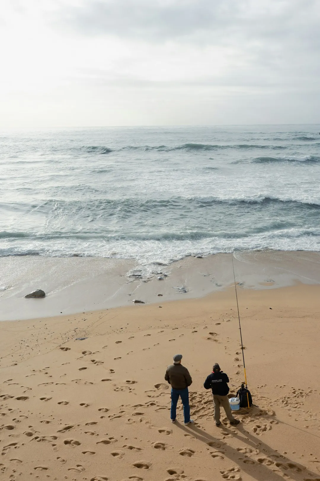
The Fishermen's Trail is a captivating exploration of the Portuguese coastline, a place where the wild Atlantic meets rugged cliffs and traditional fishing villages. Unlike many manicured coastal paths, this trail embraces the untamed nature of its environment. It often traverses sandy tracks, narrow cliff-edge paths, and sometimes requires navigating through soft sand, demanding a good level of fitness and sturdy footwear. The route is meticulously marked with red and white paint marks and yellow and red flags, guiding walkers through a diverse array of landscapes.
The trail begins in Porto Covo, a picturesque fishing village, and heads south towards Sagres, the southwesternmost point of mainland Europe. Along the way, walkers will encounter dramatic sea stacks, hidden coves, and expansive beaches that are often deserted outside of the summer season. The scent of wild herbs and pine trees fills the air, mingling with the salty spray of the ocean. The trail offers constant, awe-inspiring views of the Atlantic, with opportunities to spot seabirds, dolphins, and seals. The changing light throughout the day paints the cliffs and sea in a spectrum of colours, making each moment a photographic opportunity.
The Fishermen's Trail is not just about the natural beauty; it's also about connecting with the local culture. It passes through charming villages where time seems to have slowed down, offering glimpses into the lives of fishermen and their families. The trail is part of the larger Rota Vicentina network, which also includes the Historical Way (Caminho Histórico), a more inland route that complements the coastal experience by exploring traditional villages, cork oak forests, and agricultural landscapes. The Fishermen's Trail, however, is the undisputed star for those seeking an immersive coastal adventure.
History and Cultural Context
The Rota Vicentina, and specifically the Fishermen's Trail, owes its existence to the natural heritage of the Alentejo and Vicentine Coast Natural Park. This park, established in 1978, protects a significant stretch of coastline, preserving its unique ecosystems and traditional ways of life. For centuries, the rugged coastline has been a vital resource for local communities, primarily through fishing. The Fishermen's Trail itself is named after the local fishermen who have navigated these very paths and shores for generations, using them to access prime fishing spots, tend to their boats, and traverse the coastline.
The trail's development as a formal walking route is a more recent phenomenon, driven by a desire to promote sustainable tourism and showcase the region's natural and cultural wealth. The Rota Vicentina project, initiated in the early 2000s, aimed to create a network of marked trails that would allow visitors to experience the region's diverse landscapes while supporting local economies. The Fishermen's Trail was designed to hug the coastline as closely as possible, often following ancient paths used by fishermen and smugglers, and sometimes even requiring walkers to tread on sandy beaches or through soft sand dunes.
The region has a long history of human settlement, with evidence of prehistoric activity. However, the most visible cultural heritage today is linked to its maritime traditions. Small fishing villages like Porto Covo, Vila Nova de Milfontes, and Zambujeira do Mar retain their charm, with whitewashed houses, colourful fishing boats, and a relaxed pace of life. The trail also passes near historical sites such as the Cabo Sardão lighthouse and the dramatic cliffs of Cabo de São Vicente (Cape St. Vincent), historically known as "the end of the world" and a significant point for navigation since antiquity. The area around Sagres, with its fortress, is linked to the Age of Discoveries, particularly Prince Henry the Navigator, who established a naval school here in the 15th century.
Seasonal Highlights and Weather Reality
The Rota Vicentina, particularly the Fishermen's Trail, is best enjoyed outside the peak summer months of July and August. During this period, temperatures can soar, making hiking uncomfortable, and the coastal paths can become very exposed and hot. Furthermore, many of the smaller villages become crowded with tourists.
Spring (March to May): This is arguably the most beautiful time to walk the Fishermen's Trail. The landscape bursts into bloom with wildflowers, creating a vibrant carpet of colours against the blue of the Atlantic. The weather is generally mild and pleasant, with average temperatures ranging from 15°C to 22°C. There is a higher chance of rain compared to autumn, but showers are usually short-lived. Birdwatching is excellent during spring, with many migratory species passing through.
Autumn (September to November): Autumn offers a fantastic combination of warm, sunny days and cooler evenings. The sea is often calmer, and the light is particularly beautiful for photography. Temperatures typically range from 20°C to 28°C in September and October, gradually cooling in November. The ocean is warmer, making it more inviting for a dip after a long day's walk. This season is also excellent for spotting marine life.
Winter (December to February): While cooler, with average temperatures between 10°C and 17°C, winter can still offer pleasant walking days. However, this is the wettest period, and strong Atlantic storms can occur, bringing high winds and heavy rain. These conditions can make sections of the Fishermen's Trail impassable or dangerous, particularly those that traverse low-lying beaches or exposed cliff edges. The sea can be very rough, creating dramatic wave displays but posing a significant risk.
Summer (June to August): While the weather is reliably hot and sunny, with temperatures often exceeding 30°C, summer is generally not recommended for the Fishermen's Trail. The lack of shade on many sections, combined with the heat and potential for dehydration, makes hiking challenging. The beaches can be crowded, and accommodation may be scarce and expensive. If you choose to walk in summer, start very early, carry ample water, and be prepared for extreme heat.
Recommended Itinerary
4-Day Fishermen's Trail Itinerary (South to North)
Day 1: Porto Covo to Vila Nova de Milfontes
- Distance: 20 km
- Elevation Gain: ~200 m
- Time: 5–6 hours
- Start in Porto Covo, a charming fishing village
- Follow coastal paths, passing dramatic cliffs and small coves
- Cross the beach of Praia da Samoqueira with its unique rock formations
- Pass the iconic Ilha do Pessegueiro (Peach Tree Island) with its Roman ruins
- Descend to the Mira River estuary and cross into Vila Nova de Milfontes
- Vila Nova de Milfontes offers good accommodation and dining options
Day 2: Vila Nova de Milfontes to Almograve
- Distance: 15 km
- Elevation Gain: ~150 m
- Time: 4–5 hours
- Leave Vila Nova de Milfontes, crossing the Mira River via the bridge
- The trail continues along the coast, often on sandy paths and through pine forests
- Pass through the village of Zambujeira do Mar, known for its stunning beach and cliffs
- Continue south, with sections of beach walking and cliff paths
- Arrive in Almograve, a small coastal village with a beautiful beach
Day 3: Almograve to Carrapateira
- Distance: 25 km
- Elevation Gain: ~250 m
- Time: 7–8 hours
- This is the longest and most challenging day
- The trail traverses a more remote and wild section of coastline
- Pass the Cabo Sardão lighthouse, offering panoramic views
- Sections of beach walking and rugged cliff paths
- The landscape becomes more dramatic with towering cliffs and sea stacks
- Arrive in Carrapateira, a village nestled between two stunning beaches
Day 4: Carrapateira to Sagres
- Distance: 15 km
- Elevation Gain: ~150 m
- Time: 4–5 hours
- The final stretch of the Fishermen's Trail
- Walk along the expansive beaches of Praia do Amado and Praia da Bordeira
- The trail leads towards the dramatic cliffs of Sagres
- Pass by the Fortaleza de Sagres (Sagres Fortress)
- End the trail at Cabo de São Vicente (Cape St. Vincent), the southwesternmost point of mainland Europe
- Sagres offers a range of accommodation and transport links
Alternative 5-Day Itinerary:
- Day 1: Porto Covo to Vila Nova de Milfontes (20 km)
- Day 2: Vila Nova de Milfontes to Zambujeira do Mar (18 km)
- Day 3: Zambujeira do Mar to Almograve (15 km)
- Day 4: Almograve to Carrapateira (25 km)
- Day 5: Carrapateira to Sagres (15 km)
Important Notes:
- Accommodation in villages along the route should be booked in advance, especially during peak season.
- The trail is marked with red and white paint marks and yellow and red flags.
- Carry sufficient water and snacks, as services can be sparse between villages.
- Be aware of tide times when walking on beaches.
- The trail can be challenging due to sand and uneven terrain; sturdy hiking boots are essential.
Planning and Bookings
Book Your Trip
Everything you need to plan your journey
Accommodation
Find places to stay near Lagos
Flights
Search flights to Lagos
Essential Preparation
The Rota Vicentina Fishermen's Trail is a multi-day hike that requires careful planning, especially regarding accommodation and logistics. While no specific permits are required to walk the trail, booking accommodation in advance is highly recommended, particularly during the popular spring and autumn seasons. The trail passes through several small villages, each offering a limited number of guesthouses, B&Bs, and small hotels. It's advisable to book your lodging at least a few weeks, or even months, ahead if you plan to travel during peak times.
The closest major airport to the Rota Vicentina is Faro (FAO) in the Algarve. From Faro, you can take a bus or train to Lagos or Sines, and then connect to local buses that serve the villages along the trail. Alternatively, renting a car offers the most flexibility for reaching the trailheads and for onward travel. Porto Covo is the northern starting point, and Sagres is the southern endpoint. If you plan to walk one-way, consider arranging transport back to your starting point or using luggage transfer services. Many walkers opt to base themselves in Lagos or Sines before and after their hike, as these larger towns offer more extensive transport links and accommodation options.
Trail Accommodation
Accommodation along the Fishermen's Trail consists of a variety of options in the villages it passes through. There are no designated campsites or huts directly on the trail itself; walkers must stay in the villages.
- Guesthouses (Alojamento Local) and B&Bs: These are the most common types of accommodation, offering comfortable rooms, often with breakfast included. They are typically family-run and provide a warm, local experience.
- Small Hotels: Some villages have small hotels offering more amenities.
- Hostels: Increasingly, hostels are appearing in key villages, offering dormitory-style beds and private rooms, which can be a more budget-friendly option.
- Apartments/Vacation Rentals: For groups or those seeking more independence, renting an apartment can be a good choice.
Booking Requirements: Advance booking is essential, especially from March to June and September to October. Websites like Booking.com, Airbnb, and local tourism sites are useful for finding and booking accommodation. Some accommodations may offer luggage transfer services between villages, which can be a convenient option for reducing the weight you carry.
Facilities Provided: Typically include a bed, bathroom (private or shared), and often breakfast. Wi-Fi is usually available.
What's NOT Provided: No cooking facilities are generally provided in standard guesthouses or B&Bs. You will need to arrange your own meals at local restaurants or cafés. Sleeping bags are not required as you will be staying in established accommodations.
Seasonal Availability: Accommodation is generally available year-round, but options are more limited and prices higher during the peak seasons (spring and autumn). Some places may close during the quieter winter months.
Costs: Prices vary significantly by season and type of accommodation. Expect to pay from €40-€60 per night for a double room in a guesthouse during the shoulder season, and potentially €70-€120+ during peak times. Hostels can offer beds from €20-€30.
Required Gear
- Hiking Boots: Sturdy, waterproof hiking boots with good ankle support are crucial. The trail involves sandy sections, rocky paths, and uneven terrain. Ensure they are well broken-in to prevent blisters.
- Waterproof Jacket: A lightweight, breathable waterproof jacket is essential, as weather can change quickly, especially near the coast.
- Waterproof Overtrousers: Recommended for protection against rain and wind.
- Backpack: A comfortable daypack (25-35 litres) is sufficient if you are using luggage transfer services. If carrying all your gear, a 40-50 litre pack would be more appropriate. A rain cover for your pack is advisable.
- Head Torch: Useful for early morning starts or if staying in accommodation with limited lighting.
- First Aid Kit: Include blister plasters, antiseptic wipes, pain relievers, any personal medications, and bandages.
- Sun Protection: High SPF sunscreen, a wide-brimmed hat, and sunglasses are vital due to the exposed nature of the trail.
- Navigation Tools: While the trail is marked, a map and compass or a GPS device/app with downloaded offline maps are recommended for safety, especially in case of poor visibility or if you stray from the main path.
What to Bring
- Food and Water: Carry plenty of water (at least 2-3 litres per person per day), especially on longer stretches between villages. Snacks such as energy bars, nuts, and fruit are essential for maintaining energy levels.
- Water Treatment: While tap water in villages is generally safe, it's always wise to have a water filter or purification tablets as a backup, especially if refilling from natural sources (though this is generally not recommended on this trail).
- Clothing:
- Moisture-wicking base layers (synthetic or merino wool)
- Insulating mid-layer (fleece or lightweight down jacket)
- Comfortable hiking trousers or shorts (quick-drying material)
- Several pairs of hiking socks (wool or synthetic)
- Casual clothing for evenings
- Toiletries: Biodegradable soap, toothbrush, toothpaste, any personal hygiene items. Consider a small, quick-drying towel.
- Personal Items: Mobile phone, power bank, camera, book, journal, insect repellent (especially for evenings).
- Cash: While cards are widely accepted in larger towns, smaller villages may have limited card facilities, so carrying some Euros is advisable.
- Walking Poles: Optional, but can be very helpful for stability on sandy and uneven terrain, and for reducing strain on knees during descents.
Permits
No specific permits are required to walk the Rota Vicentina Fishermen's Trail. The trail is part of the Alentejo and Vicentine Coast Natural Park, which is a protected area, but access for walking is generally free and open to the public.
However, it is important to note the following:
- Accommodation: As mentioned in the planning section, booking accommodation in the villages along the route in advance is highly recommended, especially during the popular walking seasons (spring and autumn). This is not a permit requirement but a practical necessity.
- Camping: Wild camping is generally not permitted within the Natural Park. Designated campsites may exist in some areas, but the Fishermen's Trail is designed to be walked between villages where established accommodation is available. Stick to official accommodation to avoid issues.
- Respect for the Environment: While no permits are needed, walkers are expected to adhere to Leave No Trace principles and respect the protected status of the Natural Park. This includes staying on marked paths, not disturbing wildlife, and taking all litter with you.
The Rota Vicentina organisation provides excellent resources and maps for the trail, and it is advisable to consult their official website for the most up-to-date information regarding trail conditions and recommendations.
Other Activities in the Area
Beyond the incredible coastal hiking, the Rota Vicentina region offers a wealth of other activities:
- Surfing and Water Sports: The coastline is world-renowned for its excellent surf breaks, particularly around Sagres, Carrapateira (Praia do Amado, Praia da Bordeira), and Vila Nova de Milfontes. Many surf schools offer lessons for all levels.
- Exploring Villages: Take time to wander through the charming whitewashed villages like Porto Covo, Vila Nova de Milfontes, Zambujeira do Mar, and Sagres. Enjoy local cuisine, browse artisan shops, and soak up the relaxed atmosphere.
- Cabo de São Vicente (Cape St. Vincent): Visit the dramatic southwesternmost point of mainland Europe. Explore the historic lighthouse and enjoy the spectacular sunset views.
- Fortaleza de Sagres (Sagres Fortress): Discover the historical significance of this impressive fortress, linked to Prince Henry the Navigator and Portugal's Age of Discoveries.
- Birdwatching: The Alentejo and Vicentine Coast Natural Park is a haven for birdlife, especially during migratory seasons. Look out for storks nesting on sea stacks, various seabirds, and birds of prey.
- Gastronomy: Indulge in the delicious local cuisine, which heavily features fresh seafood, particularly grilled fish, octopus, and shellfish. Don't miss trying regional specialities like "Arroz de Marisco" (seafood rice) and "Cataplana de Peixe" (fish stew cooked in a clam-shaped copper pot).
- Diving and Snorkelling: Explore the underwater world in the clear waters off the coast, particularly around the protected marine areas.
- Cycling: The Rota Vicentina network also includes cycling routes that explore the inland areas, offering a different perspective on the region's landscapes and culture.
Safety and Conditions
Trail Conditions: The Fishermen's Trail is known for its challenging terrain, which can include soft sand, loose gravel, narrow cliff paths, and sections that may be partially submerged at high tide. Always check tide times before walking along beaches.
Weather: Coastal weather can be unpredictable. Be prepared for strong winds, sudden rain showers, and intense sun. Temperatures can vary significantly between day and night, and between coastal areas and slightly inland locations.
Navigation: While the trail is marked with red and white paint marks and yellow and red flags, it is essential to carry a map and compass or a GPS device with downloaded offline maps. Visibility can be reduced by sea mist or fog, and some sections may be less clearly defined.
Water and Food: Carry ample water (at least 2-3 litres per person per day) and high-energy snacks. Services can be infrequent between villages, so it's crucial to be self-sufficient.
Sun Protection: The sun can be very strong, especially during the warmer months. Use high SPF sunscreen, wear a hat, and sunglasses. Seek shade when possible.
Footwear: Sturdy, broken-in hiking boots are essential for ankle support and protection on the varied terrain. Blisters are a common issue, so carry a good blister kit.
Sandflies: While not as notorious as in some other regions, sandflies can be present, especially in the evenings or near marshy areas. Insect repellent is advisable.
Emergency Contacts: Know the local emergency number (112 in Portugal). Inform someone of your hiking plans, including your intended route and expected arrival times.
Respecting the Coastline: Be aware of cliff edges and unstable ground. Do not venture too close to the edge, especially in windy conditions. Avoid walking on beaches during high tide.
Side Trips and Points of Interest
Ilha do Pessegueiro (Peach Tree Island): Located just off the coast near Porto Covo, this small island is accessible by boat and features the ruins of a Roman fish-salting factory and a 17th-century fort. It's a fascinating historical detour and offers lovely views back to the mainland.
Cabo Sardão Lighthouse: This striking lighthouse stands on a dramatic cliff promontory. The surrounding cliffs are a nesting site for storks, which is unusual as storks typically nest inland. The views from here are spectacular, especially at sunset.
Praia do Amado and Praia da Bordeira: These are two of the most famous and beautiful beaches along the trail, located near Carrapateira. Praia do Amado is a popular surf spot, while Praia da Bordeira is a vast expanse of sand backed by dunes and a lagoon, offering a more wild and remote feel.
Fortaleza de Sagres: This historic fortress, perched on a rocky promontory, is a significant site related to Portugal's maritime exploration. Its imposing walls and strategic location offer a glimpse into the country's past and provide stunning panoramic views of the Atlantic.
Cabo de São Vicente (Cape St. Vincent): The southwesternmost point of mainland Europe, this is a place of immense historical and geographical significance. The dramatic cliffs, the powerful lighthouse, and the vast expanse of the Atlantic create a profound sense of being at the edge of the world. It's a popular spot for watching the sunset.
Inland Exploration (Rota Vicentina Historical Way): While the Fishermen's Trail focuses on the coast, consider dedicating a day or two to explore sections of the Historical Way. This inland route offers a contrast, showcasing cork oak forests, traditional agriculture, and charming rural villages.
Leave No Trace
The Rota Vicentina Fishermen's Trail traverses a protected natural park, and it is crucial for all walkers to practice Leave No Trace principles to preserve its beauty and ecological integrity for future generations.
Plan Ahead and Prepare: Research the trail, understand its challenges, and book accommodation in advance. Be aware of weather forecasts and tide times.
Travel and Camp on Durable Surfaces: Stick to marked trails and designated paths. Avoid walking on fragile vegetation, especially near the cliffs. Since camping is not permitted on the trail, your focus is on using established accommodation.
Dispose of Waste Properly: Pack out everything you pack in. This includes all food scraps, wrappers, and any other litter. Use designated bins in villages or take your rubbish home. Do not leave anything behind on the trail or beaches.
Leave What You Find: Do not take any natural souvenirs, such as shells, rocks, or plants. Leave the landscape as you found it.
Minimize Campfire Impacts: Campfires are not permitted on the trail or in the Natural Park. Use portable stoves if you are preparing your own food outside of villages, and ensure they are used responsibly.
Respect Wildlife: Observe wildlife from a distance. Do not feed any animals, as this can disrupt their natural behaviour and diet. Be mindful of nesting birds, especially during spring.
Be Considerate of Other Visitors: Keep noise levels down, especially in villages and natural areas. Yield to other walkers and cyclists. Respect the local culture and traditions.
By adhering to these principles, you help ensure that the Rota Vicentina remains a pristine and enjoyable destination for everyone.