Rota Vicentina - A Journey Through the Soul of Alentejo and Algarve
The Rota Vicentina is a world-class network of walking trails in Southwest Portugal, stretching across 340 kilometres of some of the most spectacular and best-preserved coastal scenery in Europe. Comprising two main routes—the Historical Way and the Fishermen's Trail—along with a series of circular routes, this trail offers a profound immersion into the rural culture of the Alentejo region and the wild, salt-sprayed cliffs of the Vicentine Coast. Starting in the historic town of Santiago do Cacém and concluding at the dramatic cliffs of Cabo de São Vicente, the southwesternmost point of continental Europe, the Rota Vicentina is more than just a hike; it is a journey through time, tradition, and a landscape that has remained remarkably resistant to the pressures of modern mass tourism. Walkers traverse ancient cork oak forests, cross wildflower-strewn meadows, and navigate narrow paths perched high above the churning Atlantic Ocean, all while staying in authentic white-washed villages where the rhythm of life is still dictated by the seasons and the sea.
- Distance: 340.0 km (total network length varies, but the main spine is approximately 340 km)
- Duration: 13 days
- Elevation Gain: 7,100 m
- Difficulty: Moderate
- Best Time: September to June (avoiding the intense summer heat)
- Closest City: Santiago do Cacém (Start) / Sagres (End)
- Direction: Generally walked North to South, though reversible
Overview
The Rota Vicentina is a masterpiece of sustainable tourism, designed to showcase the natural and cultural heritage of the Alentejo and Algarve regions without compromising their integrity. The trail is situated within the Southwest Alentejo and Vicentine Coast Natural Park, a protected area that ensures the preservation of unique botanical species, rare bird nesting sites, and a coastline that remains largely free of high-rise development. The experience is defined by its dual nature: the Historical Way (Caminho Histórico) takes walkers inland through a landscape of rolling hills, montado (cork oak) forests, and traditional farming communities, while the Fishermen's Trail (Trilho dos Pescadores) hugs the coastline, following the precarious paths used by locals to reach the best fishing spots on the cliffs.
The terrain is varied but rarely extreme. Walkers can expect a mix of sandy tracks, forest trails, gravel roads, and narrow cliff-top paths. While the elevation gain of 7,100 metres over 13 days suggests a significant amount of climbing, much of this is accumulated through the constant undulations of the coastal cliffs rather than long, sustained mountain ascents. The challenge lies more in the distance and the occasionally soft, sandy footing—particularly on the Fishermen's Trail sections—which can test the endurance of even seasoned hikers. However, the reward is a constant shifting of perspective: one moment you are deep in the silent shade of a cork forest, the next you are emerging onto a sun-drenched plateau with the vast, blue horizon of the Atlantic stretching out before you.
Culturally, the Rota Vicentina is unparalleled. Each day concludes in a different village or small town, providing an opportunity to sample the renowned Alentejo cuisine—rich in olive oil, garlic, fresh bread, and black Iberian pork—and to experience the genuine hospitality of the local people. The trail is well-marked with distinctive red and white (Historical Way) or blue and green (Fishermen's Trail) blazes, making navigation straightforward and allowing walkers to focus on the sensory details of the landscape: the scent of rockrose and eucalyptus, the sound of storks nesting on sea stacks, and the sight of the sun setting into the ocean at the end of the world.
History and Cultural Context
The Rota Vicentina is built upon layers of history that stretch back centuries. The Historical Way follows ancient paths that have been used for generations by pilgrims, travellers, and local farmers moving between the rural hinterland and the coast. These routes were the lifeblood of the region, connecting isolated homesteads (montes) to market towns and religious centres. Walking these paths today is an act of historical preservation, as many of these routes were in danger of being lost to overgrowth or modern road construction before the Rota Vicentina association was formed in 2012 to revitalise and protect them.
The Alentejo region is famous for its cork production, and the trail passes through extensive "montados"—a unique agro-silvo-pastoral system where cork oak trees are harvested every nine years. This industry has shaped the landscape and the economy for centuries, and the sight of stripped, ochre-coloured trunks is a quintessential part of the Rota Vicentina experience. The cultural heritage is also visible in the architecture of the villages: the simple, white-washed houses with blue or yellow trim around the windows and doors are designed to reflect the intense summer heat and are a hallmark of the region's aesthetic.
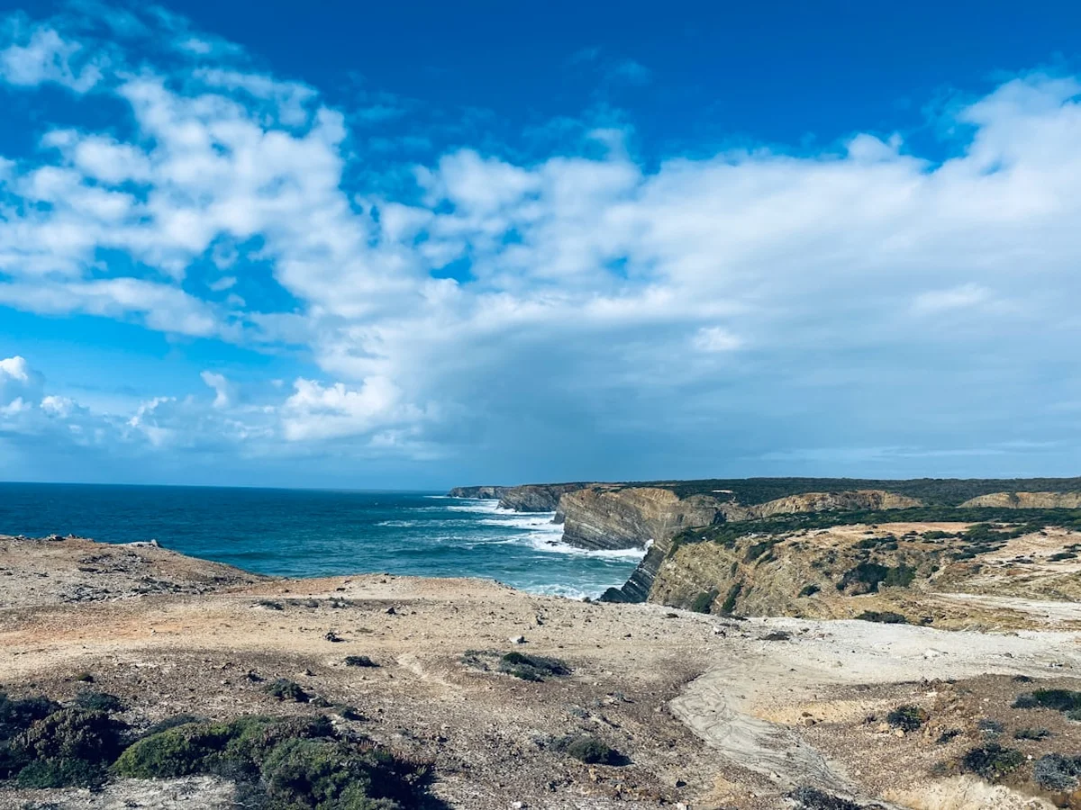
On the coast, the Fishermen's Trail tells a different story—one of survival and intimate knowledge of the sea. For centuries, local fishermen have used these narrow, dizzying paths to reach the "pesqueiros" (fishing spots) on the cliffs, often descending to the water's edge on precarious ropes or hand-carved steps. This area is also home to the only place in the world where white storks nest on sea stacks, a phenomenon that has fascinated naturalists and locals alike. The trail concludes at Cabo de São Vicente, a site of immense spiritual and historical significance. Known to the Romans as Promontorium Sacrum (Sacred Promontory), it was believed to be the point where the sun sank into the ocean, marking the end of the inhabited world. Later, it became a crucial landmark during the Portuguese Age of Discovery, as ships sailed past these cliffs on their way to explore unknown horizons.
Want more background? Read extended notes on history and cultural context → Learn more
Seasonal Highlights and Weather Reality
The Rota Vicentina is best experienced during the shoulder seasons of spring and autumn. Spring (March to May) is arguably the most beautiful time to walk, as the landscape is carpeted in a vibrant display of wildflowers, including rockrose, lavender, and various endemic orchids. The temperatures are mild, typically ranging from 15°C to 22°C, making for comfortable walking conditions. This is also the time when birdlife is most active, and the sight of storks tending to their nests on the coastal sea stacks is a highlight of the season.
Autumn (September to November) offers another excellent window. The intense heat of summer has faded, the sea remains warm enough for swimming, and the light takes on a soft, golden quality that is perfect for photography. While the landscape is drier than in spring, the air is crisp and the trails are generally quieter. Winter (December to February) is also a viable option for those seeking solitude. The Alentejo coast enjoys a Mediterranean climate with relatively mild winters, though rain is more frequent and the wind off the Atlantic can be biting. Daytime temperatures usually hover around 12°C to 16°C, which is excellent for hiking, provided you have adequate windproof and waterproof layers.
Summer (July and August) is generally discouraged for walking the Rota Vicentina. Temperatures in the Alentejo interior can frequently exceed 35°C, and there is very little shade on many sections of the trail. The coastal breeze provides some relief on the Fishermen's Trail, but the sun remains intense and the risk of heatstroke and dehydration is high. Furthermore, this is the peak holiday season in Portugal, meaning accommodation is more expensive and harder to find, and the coastal villages can be crowded with beachgoers. If you must walk in summer, it is essential to start at dawn and finish by midday to avoid the worst of the heat.
Recommended Itinerary
13-Day Rota Vicentina: The Full Journey
Day 1: Santiago do Cacém to Vale Seco
- Distance: 18 km
- Elevation gain: 450 m
- Time: 5–6 hours
- Start at the Santiago do Cacém castle, overlooking the town
- Walk through ancient cork oak forests (montados)
- Transition from urban cobblestones to soft forest tracks
- Arrive in the quiet rural hamlet of Vale Seco
- Key waypoint: The Church of Santiago, a historic starting point for pilgrims
Day 2: Vale Seco to Cercal do Alentejo
- Distance: 23 km
- Elevation gain: 500 m
- Time: 6–7 hours
- Deep immersion into the Alentejo hinterland
- Pass through diverse eucalyptus and pine plantations
- Cross small streams and navigate rolling hills
- Arrive in the traditional town of Cercal do Alentejo
- Key waypoint: Campilhas Reservoir, a peaceful spot for a mid-day break
Day 3: Cercal do Alentejo to Porto Covo
- Distance: 18 km
- Elevation gain: 200 m
- Time: 4–5 hours
- The "connection" stage between the interior and the coast
- Gradual descent towards the Atlantic Ocean
- First views of the blue horizon and the smell of salt air
- Arrive in the picturesque white-and-blue village of Porto Covo
- Key waypoint: The ridge line offering the first panoramic view of the coast
Day 4: Porto Covo to Vila Nova de Milfontes
- Distance: 20 km
- Elevation gain: 150 m
- Time: 6–7 hours
- First full day on the Fishermen's Trail
- Walking on soft sand dunes and high cliff-top paths
- Pass the historic Fort of Ilha do Pessegueiro
- Arrive in the popular seaside town of Vila Nova de Milfontes
- Key waypoint: Praia do Malhão, a vast and wild beach
Day 5: Vila Nova de Milfontes to Almograve
- Distance: 15 km
- Elevation gain: 100 m
- Time: 4–5 hours
- Cross the Mira River via the bridge or a small ferry boat
- Walk through acacia forests and along dramatic red sandstone cliffs
- Short but visually stunning stage
- Arrive in the small, quiet village of Almograve
- Key waypoint: The mouth of the Mira River, where the river meets the sea
Day 6: Almograve to Zambujeira do Mar
- Distance: 22 km
- Elevation gain: 200 m
- Time: 6–7 hours
- High cliffs and spectacular rock formations
- Pass the Cape Sardão lighthouse, where storks nest on sea stacks
- Walk through small fishing harbours carved into the cliffs
- Arrive in the iconic cliff-top village of Zambujeira do Mar
- Key waypoint: Cabo Sardão, the only place in the world with cliff-nesting storks
Day 7: Zambujeira do Mar to Odeceixe
- Distance: 18 km
- Elevation gain: 300 m
- Time: 5–6 hours
- Challenging but rewarding cliff paths
- Pass through the Azenha do Mar fishing village (great for seafood)
- Cross the border from the Alentejo region into the Algarve
- Arrive in Odeceixe, famous for its horseshoe-shaped beach
- Key waypoint: The view of Odeceixe beach from the northern cliffs
Day 8: Odeceixe to Aljezur
- Distance: 24 km
- Elevation gain: 400 m
- Time: 7–8 hours
- Follow the Seixe River inland before returning to the hills
- Walk along the Maria Vinagre irrigation canal
- Descent into the historic Moorish town of Aljezur
- Arrive in Aljezur, dominated by its hilltop castle ruins
- Key waypoint: The Aljezur Castle, offering 360-degree views of the valley
Day 9: Aljezur to Arrifana
- Distance: 12 km
- Elevation gain: 300 m
- Time: 3–4 hours
- A shorter day allowing for rest or exploration of Aljezur
- Walk through fragrant scrubland and pine forests
- Descent to the dramatic, surfer-filled bay of Arrifana
- Arrive in the small coastal settlement of Arrifana
- Key waypoint: The Arrifana Fortress ruins overlooking the bay
Day 10: Arrifana to Carrapateira
- Distance: 24 km
- Elevation gain: 500 m
- Time: 7–8 hours
- Wild, remote coastal scenery with significant undulations
- Pass the ancient Islamic fishing village of Ponta da Atalaia
- Walk across vast plateaus of rockrose and thyme
- Arrive in the surf-centric village of Carrapateira
- Key waypoint: Bordeira Beach, one of the largest and wildest in the Algarve
Day 11: Carrapateira to Vila do Bispo
- Distance: 22 km
- Elevation gain: 400 m
- Time: 6–7 hours
- Inland transition through the "Barrocal" landscape
- Pass through the quiet, traditional village of Pedralva
- Walk through wind-swept valleys and open grazing land
- Arrive in the administrative centre of Vila do Bispo
- Key waypoint: The restored village of Pedralva, a testament to rural revitalisation
Day 12: Vila do Bispo to Sagres
- Distance: 20 km
- Elevation gain: 250 m
- Time: 5–6 hours
- The final approach to the southwestern tip of Europe
- Walk along the high, limestone cliffs of the Sagres plateau
- Pass secluded beaches like Praia do Telheiro
- Arrive in the historic town of Sagres
- Key waypoint: The Sagres Fortress, where Prince Henry the Navigator studied the seas
Day 13: Sagres to Cabo de São Vicente
- Distance: 6 km (one way)
- Elevation gain: 50 m
- Time: 1.5–2 hours
- A short, ceremonial walk to the final destination
- Follow the cliff edge to the iconic red-topped lighthouse
- Experience the powerful winds and crashing waves of the Cape
- Finish at the southwesternmost point of Continental Europe
- Key waypoint: The Cabo de São Vicente Lighthouse, marking the end of the journey
Planning and Bookings
Book Your Trip
Everything you need to plan your journey
Accommodation
Find places to stay near Santiago do Cacém
Flights
Search flights to Santiago do Cacém
Essential Preparation
The Rota Vicentina requires a moderate level of fitness. While the terrain is not mountainous, the daily distances (averaging 20 km) and the soft sand on coastal sections can be physically demanding. It is highly recommended to undertake several day hikes with a weighted pack before your trip to condition your legs and feet. Logistics are relatively straightforward: most walkers fly into Lisbon (LIS) or Faro (FAO). From Lisbon, a bus (Rede Expressos) takes approximately 2 hours to Santiago do Cacém. From Faro, the journey is slightly longer, involving a train or bus to Lagos and then a local bus north.
Booking coordination is essential, especially during the peak spring months (March–May). While the trail itself requires no permits, accommodation in the smaller villages can fill up months in advance. If you prefer not to carry a full multi-day pack, several local companies offer luggage transfer services, moving your bags from one guesthouse to the next while you walk with a light daypack. This service must be booked in advance and is a popular option for those wanting to focus on the scenery rather than the weight on their backs.
Trail Accommodation
The Rota Vicentina is designed as a village-to-village walk, meaning you will stay in a variety of commercial accommodations rather than wilderness huts. This allows for a high level of comfort but requires careful planning.
Accommodation Types:
- Turismo Rural (Rural Tourism): Often converted farmhouses or traditional village homes. These offer high-quality, authentic experiences, usually including a hearty breakfast.
- Hostels: Available in larger towns like Vila Nova de Milfontes, Aljezur, and Sagres. These are budget-friendly and often have communal kitchens.
- Guesthouses and B&Bs: The most common form of accommodation, ranging from simple rooms to boutique stays.
- Campsites: Available in some locations (Porto Covo, Vila Nova de Milfontes, Zambujeira do Mar, Sagres), but wild camping is strictly prohibited within the Natural Park.
Facilities and Costs:
- Most accommodations provide bedding, towels, and WiFi.
- Breakfast is typically included in B&Bs and Rural Tourism stays.
- Costs vary: Hostels (€25–€40), Guesthouses (€60–€100), Rural Tourism (€90–€150 per night for a double room).
- Seasonal availability: Some smaller places close during the winter months (November–February).
Required Gear
- Footwear: Lightweight hiking boots or high-quality trail running shoes. Ensure they have good grip and are well broken-in. Sand gaiters are highly recommended for the Fishermen's Trail to keep grit out of your shoes.
- Clothing: Moisture-wicking base layers, a lightweight fleece or mid-layer, and a high-quality waterproof/windproof jacket. The Atlantic wind can be surprisingly cold even on sunny days.
- Navigation: While the trail is well-marked, a GPS app (like AllTrails or the official Rota Vicentina app) and a physical map are essential backups.
- Sun Protection: A wide-brimmed hat, high-SPF sunscreen, and quality sunglasses. The reflection off the sand and sea intensifies the UV exposure.
- Backpack: A 30–40L pack if using luggage transfer, or 50–65L if carrying all your gear. Ensure it has a comfortable hip belt and a rain cover.
What to Bring
- Water: At least 2–3 litres per day. While you pass through villages, some sections have no water sources for 15–20 km. A reusable bladder or bottles are essential.
- Snacks: High-energy food like nuts, dried fruit, and energy bars. Local supermarkets in the villages are great for stocking up on fresh fruit and local cheese.
- First Aid: Blister plasters (Compeed is a favourite), antiseptic cream, painkillers, and any personal medications.
- Toiletries: Biodegradable soap, travel-sized shampoo, and a small quick-dry towel if staying in hostels.
- Cash: While cards are widely accepted in larger towns, some small village cafés and guesthouses may only accept cash (Euros).
- Power Bank: To keep your phone and GPS device charged, especially on longer days.
Permits
One of the great appeals of the Rota Vicentina is its accessibility: no permits or fees are required to walk the trail. It is a public resource, maintained by a non-profit association and supported by local municipalities. However, because the trail passes through the Southwest Alentejo and Vicentine Coast Natural Park, walkers must adhere to strict environmental regulations to ensure the continued protection of this fragile ecosystem.
Key Regulations:
- No Wild Camping: Camping is only permitted in designated campsites. This is strictly enforced to prevent erosion, fire risk, and disturbance to wildlife.
- Stay on the Path: The coastal dunes and cliff edges are highly susceptible to erosion. Straying from the marked trail can destroy rare endemic plants and destabilise the ground.
- Fire Safety: Portugal has a high risk of forest fires, especially from May to October. Lighting fires or discarding cigarette butts is strictly prohibited and carries heavy fines.
- Group Sizes: While there is no formal limit for independent walkers, large organised groups (over 20 people) are encouraged to contact the Rota Vicentina association in advance to ensure their impact is managed.
Booking Strategy: Although no permit is needed, your "permit" to a comfortable journey is your accommodation booking. For the peak months of April and May, it is wise to book your stays 4–6 months in advance. If you find that a particular village is full, consider looking at "Turismo Rural" options slightly off-trail; many hosts offer pick-up and drop-off services for hikers.
Other Activities in the Area
The Southwest coast of Portugal offers a wealth of experiences beyond hiking. Consider adding a few rest days to your itinerary to enjoy the following:
- Surfing: The Vicentine Coast is world-renowned for its surf. Arrifana, Carrapateira, and Sagres offer excellent waves for all levels, with numerous surf schools providing lessons and equipment rental.
- Bird Watching: The Sagres peninsula is a major migratory bottleneck. In autumn, thousands of soaring birds (eagles, vultures, storks) can be seen crossing the Atlantic. The cliffs near Cabo Sardão are also the only place in the world where white storks nest on sea stacks.
- Wine Tasting: The Alentejo is one of Portugal's premier wine regions. Many "herdades" (estates) near Santiago do Cacém and Cercal offer tours and tastings of their robust reds and crisp whites.
- Canoeing and SUP: The Mira River in Vila Nova de Milfontes and the Seixe River in Odeceixe are perfect for a peaceful paddle through the marshes and estuaries.
- Gastronomy Tours: Spend an afternoon in a local market or take a cooking class to learn the secrets of Alentejo's "bread soups" (açordas) and fresh seafood dishes.
- Historical Exploration: Visit the Sagres Fortress, the Aljezur Castle, or the Roman ruins of Miróbriga near Santiago do Cacém to delve deeper into the region's long and varied history.
Safety and Conditions
The Rota Vicentina is generally a safe trail, but the coastal environment and the Mediterranean climate present specific challenges that walkers must be prepared for.
Cliff Safety: The Fishermen's Trail often runs very close to the cliff edge. These cliffs are composed of sedimentary rock and are subject to constant erosion. Never cross fences or ignore warning signs, and stay well back from the edge, especially in high winds. The ground can be unstable, and landslides are a genuine risk after heavy rain.
Heat and Hydration: Dehydration and heat exhaustion are the most common medical issues on the trail. Even in the shoulder seasons, the sun can be intense. Drink water regularly, even if you don't feel thirsty, and use electrolyte replacements on particularly hot days. Wear a hat and apply sunscreen every few hours.
Navigation and Connectivity: While the trail is excellently marked, it is possible to miss a blaze, especially in areas where multiple paths intersect. Always carry a digital or physical map. Mobile signal is generally good along the coast and in villages, but there are "dead zones" in the deeper valleys and remote forest sections of the Historical Way.
Wildlife: There are no dangerous large animals on the trail. You may encounter snakes (mostly non-venomous) and spiders; simply give them space and they will move on. Ticks can be present in long grass during the spring, so check your legs at the end of each day. Stray dogs are rare but occasionally seen near farms; they are usually more interested in guarding their territory than bothering hikers. If you encounter one, stay calm, keep moving, and do not make eye contact.
Emergency Services: The national emergency number in Portugal is 112. Most villages have a "Farmácia" (pharmacy) for minor ailments and a "Centro de Saúde" (health centre) for non-emergency medical issues. Ensure you have comprehensive travel insurance that covers hiking activities.
Side Trips and Points of Interest
The Rota Vicentina is dotted with hidden gems that are worth a small detour or an extra hour of exploration:
Pego das Pias: Located near Odemira (accessible via a side trail from the Historical Way), this is a stunning natural pool carved into the rock by the Torgal stream. It is a perfect, shaded spot for a wild swim in crystal-clear water, surrounded by dramatic geological formations.
Ilha do Pessegueiro: Just south of Porto Covo, you can see this small island with its 16th-century fort ruins. While you cannot easily visit the island itself, the view from the mainland fort (Forte de Nossa Senhora da Queimada) is spectacular, especially at sunset.
Praia da Amado: Near Carrapateira, this beach is a cathedral of surfing and geology. The multi-coloured cliffs (red, yellow, and grey) provide a stunning backdrop to the powerful Atlantic rollers. It is worth spending an afternoon here just to watch the surfers and the changing light on the rocks.
The Labyrinth of Aljezur: The old town of Aljezur is a maze of narrow, steep streets that wind up to the castle. Take the time to wander away from the main trail to discover small art galleries, traditional bakeries, and hidden viewpoints over the lush river valley.
Ermida de Nossa Senhora de Guadalupe: Located between Vila do Bispo and Sagres, this 13th-century chapel is one of the few remaining examples of Gothic-Romanesque architecture in the Algarve. It is said to have been a place of prayer for Prince Henry the Navigator.
Leave No Trace
The Rota Vicentina passes through a fragile and protected landscape. As a walker, you have a responsibility to minimise your impact and help preserve the beauty of the Alentejo and Algarve for future generations.
Core Principles:
- Pack it in, pack it out: Carry all your rubbish with you until you reach a village with proper disposal facilities. This includes organic waste like fruit peels, which can take a long time to decompose in the dry climate and can attract unwanted wildlife.
- Respect the Dunes: The dune systems are vital for coastal protection. Always use the designated boardwalks or marked paths to avoid crushing the delicate vegetation that holds the sand in place.
- Water Conservation: Water is a precious resource in southern Portugal. Use it sparingly in guesthouses and never contaminate natural water sources with soap or detergents.
- Protect the Flora: Do not pick wildflowers or disturb the cork oak trees. The "montado" is a working landscape; respect the trees and the livelihoods of those who manage them.
- Wildlife Etiquette: Observe animals from a distance. Do not feed birds or stray animals, as this can disrupt their natural behaviours and diet.
- Quiet Enjoyment: Keep noise to a minimum to avoid disturbing both wildlife and the peaceful atmosphere of the rural villages.