The Ridgeway Trail - Britain's Oldest Road
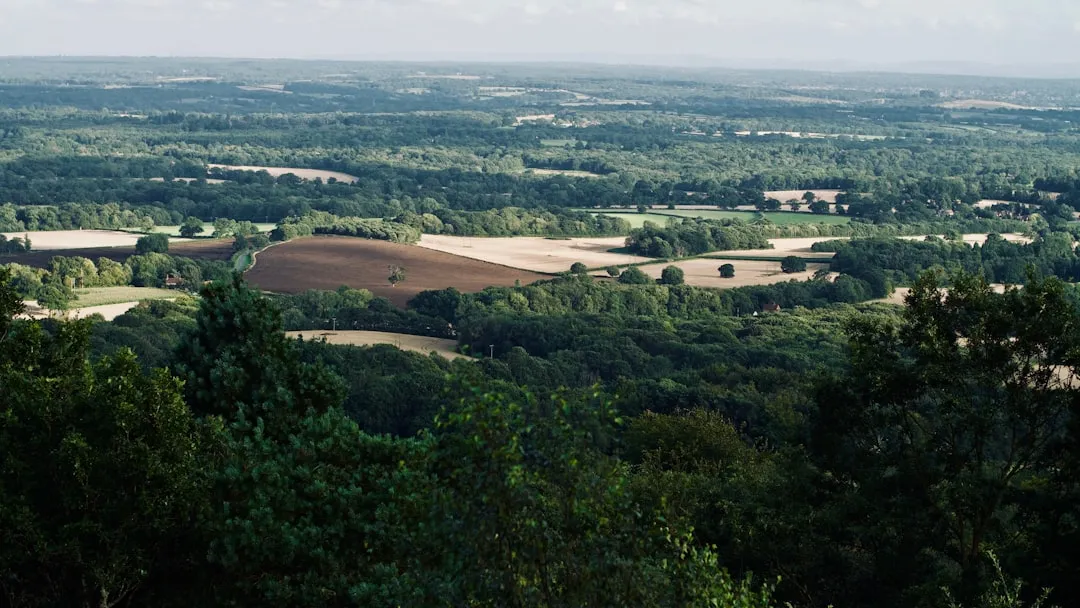
The Ridgeway is a National Trail stretching 136.8 km (137 km) across the North Wessex Downs and Cotswolds Areas of Outstanding Natural Beauty. Often cited as Britain's oldest road, its origins lie in prehistoric trackways used by Neolithic peoples over 5,000 years ago. This ancient route follows the chalk ridge of the Berkshire Downs and Oxfordshire Cotswolds, offering a journey through rolling landscapes, ancient woodlands, and a rich tapestry of history. Unlike many linear trails, the Ridgeway is not a single, continuous path but a network of ancient tracks, bridleways, and footpaths, predominantly following the crest of the hills. This elevated position provides expansive views and a sense of timelessness, connecting walkers to centuries of human passage.
- Distance: 137 km (136.8 km)
- Duration: 6-7 days
- Season: April-October (best weather, wildflowers, and open views)
- Accommodation: Mix of campsites, B&Bs, pubs with rooms, and small hotels
- Highest point: Near Sparsholt (approx. 250 m)
- Difficulty: Moderate (due to distance and some uneven terrain, but generally well-trodden)
- Direction: West to East (conventional, but can be walked in either direction)
Overview
The Ridgeway offers a unique walking experience, tracing a route that has been trodden by countless generations. From its western terminus near Avebury, a UNESCO World Heritage Site and one of the most important Neolithic sites in Britain, the trail heads eastwards. It meanders through landscapes that have changed little over millennia, punctuated by Bronze Age burial mounds, Iron Age hill forts, and Roman roads. The path itself is often wide and well-defined, a testament to its historical use by drovers, armies, and travellers.
The terrain is predominantly rolling chalk downland, interspersed with sections of woodland and farmland. While not technically challenging, the length requires a good level of fitness and stamina. The views are a constant reward, stretching across wide valleys and picturesque countryside. The trail passes through charming villages and market towns, offering opportunities to rest, resupply, and experience local hospitality. The Ridgeway is a journey through time, a chance to walk in the footsteps of our ancestors and connect with the enduring spirit of the English countryside.
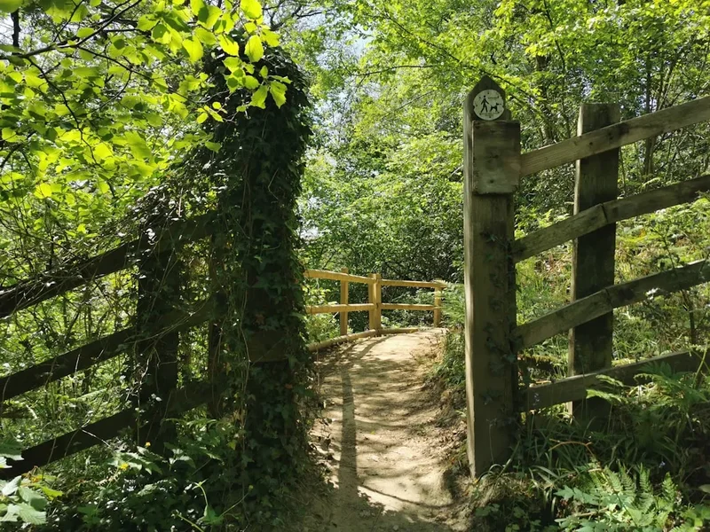
The trail is well-signposted with the distinctive acorn symbol of National Trails. However, due to its nature as a network of ancient tracks, some sections may be shared with cyclists and horse riders, and the path can be muddy after rain, particularly on chalky ground. The best time to walk is generally spring and summer, when the wildflowers are in bloom and the days are long, though autumn also offers beautiful colours and fewer crowds.
History and Cultural Context
The Ridgeway's history is deeply intertwined with the human story of Britain. Its origins predate recorded history, with evidence suggesting its use as a route by Neolithic peoples as far back as 5,000 years ago. These early travellers likely used the high ground to avoid marshy valleys and dense forests, establishing a trackway that would be used and maintained for millennia.
During the Bronze Age (c. 2500–800 BC), the route became dotted with burial mounds, known as barrows, many of which still stand today as silent sentinels of the past. The Iron Age (c. 800 BC – AD 43) saw the construction of impressive hill forts along the ridge, such as Barbury Castle and Uffington Castle, serving as defensive settlements and centres of power. These sites offer a tangible connection to the strategic importance of the Ridgeway's elevated position.
The Romans, who arrived in AD 43, recognised the value of the Ridgeway and often built their own roads alongside or intersecting it. The Icknield Way, another ancient track, runs parallel to parts of the Ridgeway, and the two routes frequently merge and diverge. Later, during the medieval period, the Ridgeway continued to be a vital artery for trade and travel, used by drovers moving livestock and by armies marching across the country. Its strategic importance was recognised again during World War II, when it was used for military movements.
The designation of the Ridgeway as a National Trail in 1973 ensured its preservation and accessibility for walkers, cyclists, and horse riders, allowing modern generations to experience this ancient pathway and its profound historical significance.
Seasonal Highlights and Weather Reality
The Ridgeway is a year-round trail, but its character and the experience it offers vary significantly with the seasons.
Spring (April-May): This is a particularly beautiful time to walk the Ridgeway. The chalk downlands burst into life with a vibrant display of wildflowers, including cowslips, orchids, and bluebells in the wooded sections. The air is fresh, and the days begin to lengthen, offering ample daylight for walking. Birdsong is abundant, and the landscape is often bathed in soft, clear light. However, spring can also bring unpredictable weather, with occasional cold snaps and rain showers.
Summer (June-August): The summer months offer the warmest weather and longest daylight hours, ideal for completing the trail. The rolling hills are covered in lush green grass, and the views can be extensive on clear days. This is also peak season for many of the villages and attractions along the route. However, summer can also bring heatwaves, and water sources may be less plentiful in some areas. The wide, open sections of the Ridgeway can be exposed to strong sun, so sun protection is essential.
Autumn (September-October): Autumn transforms the Ridgeway into a spectacle of colour. The deciduous woodlands turn shades of gold, red, and brown, creating a stunning visual contrast with the chalky downs. The air is often crisp and clear, offering excellent visibility. The crowds of summer have thinned, making for a more peaceful walking experience. However, days become shorter, and the weather can become more unsettled, with increased chances of rain and wind.
Winter (November-March): While less popular, winter walking on the Ridgeway has its own stark beauty. The landscapes are often dramatic, with frost and mist creating atmospheric scenes. The absence of foliage in the woodlands opens up views that are hidden in summer. However, winter brings shorter days, colder temperatures, and a higher likelihood of muddy and slippery conditions, especially on chalky sections. Some facilities, such as campsites, may be closed during this period.
Weather: The weather in this region of England can be highly variable at any time of year. Expect sunshine, rain, wind, and cooler temperatures, sometimes all within the same day. Layering clothing is essential, and waterproofs are a must, regardless of the season.
Recommended Itinerary
6-Day Ridgeway Itinerary (West to East)
Day 1: Avebury to Hackpen Hill
- Distance: 16 km (16.1 km)
- Elevation gain: 200 m
- Time: 4–5 hours
- Start at the iconic West Kennet Long Barrow, near Avebury stone circle
- Follow the Ridgeway eastwards, passing through rolling chalk downland
- Key Waypoints: West Kennet Long Barrow, Silbury Hill (view from afar), Windmill Hill, Hackpen Hill
- Accommodation: Camping near Hackpen Hill or B&B in Broad Hinton
- This day offers a gentle introduction to the trail, with significant prehistoric sites and expansive views
Day 2: Hackpen Hill to Lewknor
- Distance: 22 km (22.5 km)
- Elevation gain: 300 m
- Time: 6–7 hours
- Continue along the chalk ridge, with views towards the Vale of White Horse
- Pass through charming villages and farmland
- Key Waypoints: Barbury Castle (Iron Age hill fort), Liddington Castle (Iron Age hill fort), White Horse Hill (iconic chalk horse), Wayland's Smithy (Neolithic long barrow)
- Accommodation: B&B or pub with rooms in Lewknor or nearby villages
- A day rich in history, featuring significant Iron Age forts and the famous White Horse
Day 3: Lewknor to Watlington
- Distance: 18 km (17.7 km)
- Elevation gain: 250 m
- Time: 5–6 hours
- The trail crosses the M40 motorway via a bridge and continues through mixed woodland and farmland
- Pass through the Chiltern Hills Area of Outstanding Natural Beauty
- Key Waypoints: Aston Rowant National Nature Reserve (chalk grassland), Watlington Hill
- Accommodation: Pub with rooms or hotel in Watlington
- A transition day into the Chilterns, offering varied scenery and woodland walks
Day 4: Watlington to Wendover
- Distance: 20 km (20.1 km)
- Elevation gain: 350 m
- Time: 6–7 hours
- A more challenging day with significant ascents and descents through the Chilterns
- Pass through ancient beech woodlands and open downland
- Key Waypoints: Christmas Common, Beacon Hill, Coombe Hill (National Trust viewpoint)
- Accommodation: Campsite, B&B, or hotel in Wendover
- This day offers some of the most dramatic scenery in the Chilterns, with excellent viewpoints
Day 5: Wendover to Ivinghoe
- Distance: 24 km (24.1 km)
- Elevation gain: 300 m
- Time: 7–8 hours
- The trail continues along the Chiltern escarpment, with views towards the Vale of Aylesbury
- Pass through more woodland and open countryside
- Key Waypoints: Wendover Woods, Ashridge Estate (National Trust), Aldbury village
- Accommodation: Campsite or B&B in Ivinghoe or nearby
- A longer day, but with varied landscapes and the opportunity to explore the Ashridge Estate
Day 6: Ivinghoe to Pavis Way (near Hitchin)
- Distance: 17 km (16.9 km)
- Elevation gain: 200 m
- Time: 5–6 hours
- The final section of the Ridgeway, heading towards its eastern end
- The landscape becomes flatter as it approaches the Hertfordshire border
- Key Waypoints: Ivinghoe Beacon, Dunstable Downs (National Trust), Whipsnade Zoo (view from afar), Pavis Way (official end of the Ridgeway)
- End point: Pavis Way, near Hitchin. Public transport links available from nearby towns.
- A concluding day with iconic views from Ivinghoe Beacon and Dunstable Downs
Alternative 7-Day Itinerary: For a more relaxed pace, consider splitting Day 2 or Day 4 into shorter sections, allowing more time for exploration and rest.
Planning and Bookings
Book Your Trip
Everything you need to plan your journey
Accommodation
Find places to stay near Avebury
Flights
Search flights to Avebury
Essential Preparation
The Ridgeway is a well-established trail, but careful planning is still essential for an enjoyable experience. Given its length and the need for overnight stays, booking accommodation in advance is highly recommended, especially during peak season (spring and summer). Consider your preferred pace and break the trail into manageable daily sections. Researching transport options to and from the trailheads is crucial; the western end near Avebury is accessible by train to Swindon followed by a bus, while the eastern end near Hitchin has good train links. For those driving, parking can be found in larger villages and towns, but availability may be limited.
The closest major city to the western end is Swindon, which offers comprehensive services and transport links. For the eastern end, towns like Hitchin and Dunstable provide similar amenities. Familiarise yourself with the trail's route using maps and guidebooks, and be prepared for varying weather conditions. The Ridgeway is generally well-signposted, but a map and compass or GPS device are always advisable for navigation, especially in poor visibility or on less distinct sections.
Trail Accommodation
Accommodation options along the Ridgeway are varied and generally good, catering to different budgets and preferences. There are no designated National Trail huts; instead, walkers typically use a combination of:
- Campsites: Numerous campsites are located along or near the trail, offering basic facilities such as pitches, toilets, and sometimes showers. Some are dedicated caravan and camping sites, while others are smaller, more informal sites. Booking in advance is advised, particularly during school holidays and summer weekends.
- B&Bs and Guesthouses: Many charming villages along the route offer bed and breakfast accommodation, providing comfortable rooms and a hearty breakfast to start your day.
- Pubs with Rooms: A classic British countryside experience, many pubs offer rooms for rent, often combined with excellent food and local ales. This is a popular choice for walkers seeking convenience and a traditional atmosphere.
- Small Hotels: Larger towns and villages may have small hotels offering more extensive facilities.
Booking Requirements: It is strongly recommended to book accommodation at least 2-3 months in advance, especially for popular locations and during peak season (April-October). Many B&Bs and pubs have limited rooms.
Facilities Provided: Typically include a bed, breakfast (for B&Bs/pubs), and access to shared or en-suite bathrooms. Campsites provide pitches and basic amenities.
What's NOT Provided: Sleeping bags and mats (for campsites), toiletries, and personal items. Food and drink (beyond breakfast) will need to be purchased separately.
Seasonal Availability: Most accommodation is available from spring through autumn. Some campsites may close during winter months. Pubs and B&Bs generally operate year-round but may have reduced availability or opening hours in the off-season.
Costs: Campsite pitches typically range from £15-£30 per night. B&Bs and pub rooms can range from £70-£150 per night for a double room. Hotel prices will vary.
Required Gear
- Sturdy Walking Boots: Waterproof, with good ankle support and a well-worn sole. Essential for comfort and preventing injuries on varied terrain.
- Waterproof Jacket: Breathable and fully waterproof with taped seams. Essential for unpredictable British weather.
- Waterproof Overtrousers: Lightweight and packable, to keep your lower half dry.
- Comfortable Walking Trousers: Quick-drying material is preferable to cotton.
- Base Layers: Merino wool or synthetic thermals for warmth and moisture-wicking.
- Mid Layers: Fleece jacket or insulated gilet for insulation.
- Socks: Several pairs of good quality walking socks (wool or synthetic blend).
- Backpack: 40-60 litre capacity, with a comfortable harness and hip belt. A rain cover is essential.
- Navigation: Ordnance Survey (OS) maps of the relevant areas (Explorer series recommended), compass, and a GPS device or smartphone with offline mapping app.
- Head Torch: With spare batteries, for early starts, late finishes, or emergencies.
- First Aid Kit: Including blister plasters, pain relievers, antiseptic wipes, bandages, and any personal medication.
- Sun Protection: Sunscreen (SPF 30+), sunglasses, and a wide-brimmed hat.
- Insect Repellent: Particularly useful during summer months for midges and other biting insects.
What to Bring
- Food: Packed lunches and snacks for each day's walk. Consider lightweight, high-energy options. Some villages have shops, but resupply points can be infrequent.
- Water Bottles/Bladder: Capacity for at least 1.5-2 litres per person. Water sources are available in villages, but carrying enough for the day is recommended. Water purification tablets or a filter are advisable for refilling from natural sources if necessary.
- Toiletries: Biodegradable soap, toothbrush, toothpaste, small towel, hand sanitiser.
- Personal Items: Mobile phone, charger, power bank, camera, book, journal.
- Money: Cash for small purchases, campsites, and some rural pubs/shops that may not accept cards.
- Trekking Poles: Optional, but can be beneficial for stability and reducing strain on joints, especially on descents.
- Duct Tape: Invaluable for quick repairs to gear.
- Whistle: For emergencies.
Permits
No specific permits are required to walk the Ridgeway National Trail. As a public right of way and a designated National Trail, it is accessible to all. However, access to certain areas, such as National Trust properties (e.g., Ashridge Estate, Dunstable Downs), is governed by their own access policies, which are generally very permissive for walkers.
Booking Accommodation: While no permits are needed for the trail itself, booking accommodation in advance is essential, especially during the popular spring and summer months. Popular B&Bs, pubs with rooms, and campsites can fill up quickly, particularly in smaller villages.
National Trust Properties: The Ridgeway passes through several National Trust properties. While access is generally free for walkers, donations are always welcome to help maintain these beautiful landscapes. Information about specific sites can be found on the National Trust website.
Cycling and Horse Riding: The Ridgeway is also a designated bridleway, meaning cyclists and horse riders have the right to use it. While generally well-managed, be aware of other users and share the path courteously. Some sections may be more suited to walking than cycling due to terrain.
Respecting the Environment: While no permits are required, walkers are expected to adhere to the principles of Leave No Trace (see section 11) and respect the natural environment and local communities.
Other Activities in the Area
The Ridgeway passes through areas rich in history and natural beauty, offering numerous opportunities for exploration beyond the trail itself:
- Avebury Stone Circle and Museum: Explore one of Britain's most significant Neolithic sites, a UNESCO World Heritage Site, with its massive standing stones and associated monuments. The Alexander Keiller Museum provides fascinating insights into the site's history.
- Walking the White Horse Trail: Near the Ridgeway's passage through Oxfordshire, discover the famous chalk horses carved into the hillsides, including the iconic Uffington White Horse.
- Visiting Iron Age Hill Forts: Sites like Barbury Castle and Uffington Castle offer a glimpse into prehistoric defensive structures and provide excellent viewpoints.
- Exploring Market Towns: Towns such as Wantage, Watlington, and Hitchin offer charming streets, independent shops, historic buildings, and local markets.
- National Trust Properties: The Ashridge Estate and Dunstable Downs provide extensive walking opportunities, visitor centres, and stunning views.
- Whipsnade Zoo: Located near the eastern end of the Ridgeway, this large conservation park offers a family-friendly day out.
- Chiltern Hills AONB: Explore the wider area of the Chilterns, known for its rolling hills, ancient woodlands, and picturesque villages, with numerous other walking and cycling routes.
- Local Pubs and Restaurants: Enjoy traditional British cuisine and local ales in the many welcoming pubs and restaurants along the route.
Safety and Conditions
Terrain: The Ridgeway is predominantly a well-defined track, often wide and relatively easy underfoot. However, sections can be chalky and become very slippery and muddy after rain. Some ascents and descents can be steep, particularly in the Chilterns. Be prepared for uneven ground and occasional rocky patches.
Weather: British weather is notoriously changeable. Be prepared for sun, rain, wind, and cooler temperatures, even in summer. Always check the forecast before setting out each day and carry appropriate clothing layers.
Navigation: While the Ridgeway is generally well-signposted with the acorn symbol, it is advisable to carry Ordnance Survey maps and a compass or GPS device. Some sections may be less distinct, and visibility can be reduced in fog or heavy rain.
Water Sources: Water is generally available in villages along the route, but resupply points can be infrequent. Carry sufficient water for each day's walk, especially during warmer months. Water purification tablets or a filter are recommended if you plan to refill from natural sources.
Wildlife: You may encounter livestock, including sheep and cattle, grazing in fields along the route. Always keep a safe distance and close gates behind you. Ticks can be present in grassy and wooded areas, particularly during warmer months; check yourself for ticks after walking.
Emergencies: In case of a medical emergency, dial 999 or 112 and ask for the relevant service (Ambulance, Police). Be prepared to give your precise location, which can be challenging on a linear trail. A mobile phone with a good signal is essential, but coverage can be patchy in rural areas. Consider carrying a personal locator beacon (PLB) for remote sections.
Shared Use: Remember that the Ridgeway is also used by cyclists and horse riders. Be courteous and aware of other users, especially on narrow sections.
Side Trips and Points of Interest
Avebury Stone Circle: While technically the start/end point, dedicating time to explore the vast Avebury stone circle, West Kennet Long Barrow, and Silbury Hill is highly recommended. These Neolithic monuments offer a profound connection to Britain's ancient past.
White Horse Hill and Uffington Castle: A highlight of the trail, this iconic chalk horse is a must-see. The adjacent Iron Age hill fort, Uffington Castle, offers commanding views and a sense of history. Nearby Wayland's Smithy is another impressive Neolithic long barrow.
Barbury Castle: An impressive Iron Age hill fort with well-preserved ramparts, offering panoramic views over the surrounding countryside. It's a significant historical site and a great spot for a break.
Aston Rowant National Nature Reserve: This beautiful chalk grassland reserve is home to a variety of rare plants and butterflies, particularly in spring and summer. The Ridgeway passes through it, offering a chance to appreciate its delicate ecosystem.
Coombe Hill: A National Trust viewpoint in the Chilterns offering spectacular vistas across the Vale of Aylesbury. It's a perfect spot for a picnic and to appreciate the rolling landscape.
Ashridge Estate: A vast National Trust property with ancient woodlands, open grasslands, and historic parkland. The Ridgeway traverses a significant portion of the estate, offering diverse walking experiences and opportunities for wildlife spotting.
Ivinghoe Beacon: One of the most iconic viewpoints on the Ridgeway, offering breathtaking 360-degree views across Buckinghamshire and Hertfordshire. It's a popular spot for kite flying and enjoying the expansive scenery.
Leave No Trace
The Ridgeway traverses areas of significant natural beauty and historical importance. Adhering to Leave No Trace principles ensures that these landscapes are preserved for future generations and that the impact of walkers is minimised.
- Plan Ahead and Prepare: Familiarise yourself with the trail, weather conditions, and local regulations. Book accommodation in advance to avoid disappointment and reduce last-minute stress.
- Travel and Camp on Durable Surfaces: Stick to the marked paths and bridleways. Avoid walking on fragile vegetation, especially chalk grassland, which can be easily damaged. If camping, use designated campsites or choose a hard, non-vegetated surface away from water sources.
- Dispose of Waste Properly: Pack out everything you pack in, including all litter, food scraps, and toilet paper. Use designated bins in villages or take your waste home. If you must go to the toilet in the countryside, dig a cathole at least 60 metres (60 m) away from water, trails, and campsites, and bury your waste.
- Leave What You Find: Do not disturb or remove any natural objects, historical artefacts, or cultural heritage sites. Take only photographs and memories.
- Minimise Campfire Impacts: Campfires are generally discouraged on the Ridgeway due to the risk of wildfire and damage to the landscape. Use a lightweight stove for cooking. If a campfire is absolutely necessary and permitted, use an existing fire ring and ensure it is completely extinguished before leaving.
- Respect Wildlife: Observe wildlife from a distance and never feed animals. Be aware of livestock grazing in fields and maintain a safe distance.
- Be Considerate of Other Visitors: Yield to other users on the trail, especially horse riders and cyclists. Keep noise levels down and respect the peace and quiet of the countryside.
By following these principles, you contribute to the conservation of the Ridgeway and ensure a positive experience for yourself and others.