Rheinquellhorn Loop - Alpine Majesty in the Swiss Alps
The Rheinquellhorn Loop is a spectacular day walk nestled high in the Swiss Alps, offering a challenging yet immensely rewarding experience for seasoned hikers. This route circumnavigates the Rheinquellhorn, a prominent peak in the heart of the Graubünden canton, providing breathtaking panoramic views of rugged alpine landscapes, pristine glacial lakes, and distant snow-capped summits. The trail is characterised by its demanding ascents and descents, traversing varied terrain from lush alpine meadows to rocky scree slopes and exposed ridges. It is a true test of endurance and a celebration of the raw, untamed beauty of the Swiss Alps, demanding careful planning and a good level of fitness.
- Distance: 14.5 km
- Elevation Gain: 1350 m
- Duration: 6-8 hours
- Difficulty: Challenging
- Season: July to September (summer months), dry conditions
- Closest City: Chur
- Trailhead Access: Nearest city: Chur. From Chur, take a bus to Hinterrhein (approx. 1.5 hrs). From Hinterrhein, a short taxi ride or hike (1-2 hours) is required to reach the trailhead. Driving is possible with parking available near Hinterrhein. Road conditions are generally good.
- Permits: No permits required.
Overview
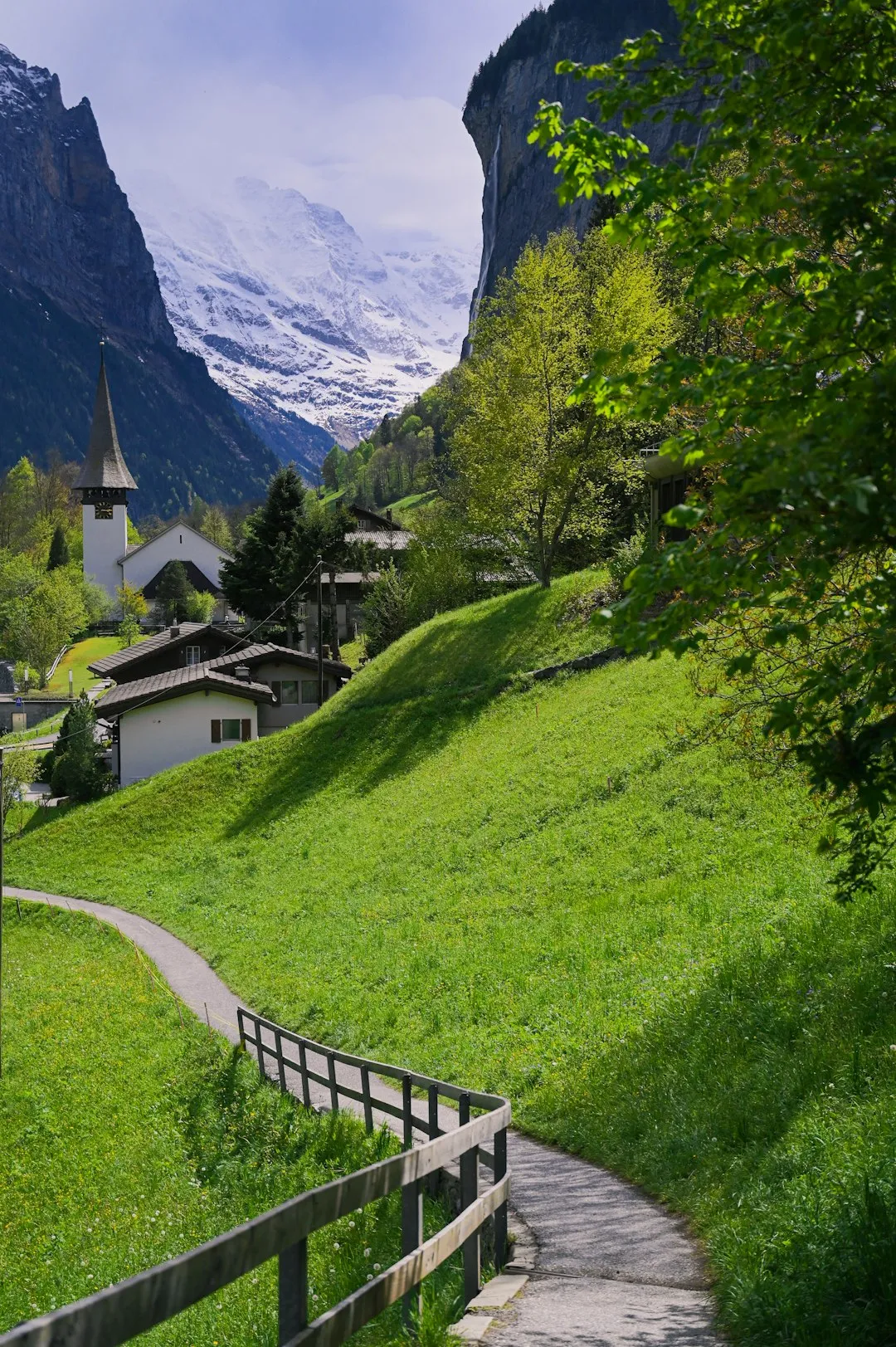
The Rheinquellhorn Loop is a demanding yet incredibly scenic day hike that showcases the dramatic alpine scenery of the Swiss Alps. This circular route is designed for experienced hikers who are comfortable with significant elevation changes and rugged terrain. The journey begins with a steady climb, gradually ascending through verdant alpine pastures dotted with wildflowers during the summer months. As the trail gains altitude, the vegetation thins, giving way to more exposed rocky sections and scree slopes that lead towards the higher reaches of the loop.
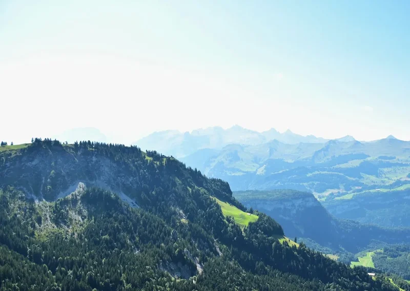
The highlight of the Rheinquellhorn Loop is undoubtedly the commanding views it offers. From its highest points, walkers are treated to sweeping vistas of the surrounding mountain ranges, including glimpses of the mighty peaks that define the Swiss Alps. The trail often skirts the edges of dramatic drop-offs, providing thrilling perspectives of the valleys below and the intricate network of ridges and gullies that characterise this high-alpine environment. Several small, crystal-clear alpine lakes are often encountered along the route, their still waters reflecting the imposing mountain scenery, offering moments of serene beauty amidst the challenging ascent.
The descent is as demanding as the climb, often involving steep, rocky paths that require careful foot placement and concentration. The trail eventually winds back down through alpine meadows, offering a different perspective on the landscape as the day draws to a close. The Rheinquellhorn Loop is not for the faint-hearted; it requires a good level of physical fitness, sure-footedness, and a head for heights. However, for those who are prepared, the rewards are immense: an unforgettable immersion in the grandeur of the Swiss Alps, a sense of accomplishment, and memories of unparalleled natural beauty.
History and Cultural Context
The region surrounding the Rheinquellhorn has a long history of human interaction, primarily driven by pastoralism and, in more recent times, mountaineering and tourism. For centuries, these high alpine pastures were used by local communities for grazing livestock during the summer months. The challenging terrain and harsh climate meant that permanent settlements were not feasible, but the seasonal migration of herds to these rich meadows was a vital part of the local economy and way of life.
The development of mountaineering in the Alps during the 19th century brought increased attention to peaks like the Rheinquellhorn. Explorers and adventurers were drawn to the challenge of conquering these formidable summits. While the Rheinquellhorn itself might not be as famous as some of the iconic peaks of the Bernese Oberland, it represents the quintessential Swiss alpine experience – rugged, beautiful, and demanding. The trails that now form the Rheinquellhorn Loop are likely descendants of ancient herding paths and early mountaineering routes, adapted and maintained over time to accommodate the growing interest in alpine hiking.
The closest village, Hinterrhein, has a history deeply intertwined with the surrounding mountains. Its location at the foot of the San Bernardino Pass has made it a strategic point for travellers for centuries. Today, while traditional pastoralism continues on a smaller scale, the primary economic driver for the region is tourism, with hiking and mountaineering attracting visitors from around the world. The Rheinquellhorn Loop, in its current form, is a testament to the enduring appeal of the Swiss Alps and the human desire to explore and connect with these magnificent natural landscapes.
Seasonal Highlights and Weather Reality
The Rheinquellhorn Loop is a high-altitude trail, and its accessibility and conditions are heavily dictated by the seasons. The optimal period for undertaking this challenging hike is during the summer months, typically from July to September. During this time, the snow has largely receded from the higher elevations, and the alpine meadows are often carpeted with vibrant wildflowers, creating a stunning visual spectacle.
Summer (July to September): This is the prime season for the Rheinquellhorn Loop. The days are longer, offering ample daylight for the 6-8 hour hike. Temperatures are generally mild, though they can fluctuate significantly with altitude and weather changes. Expect daytime temperatures to range from 10°C to 20°C in the valleys, but it can be considerably colder at higher elevations, especially in the early morning or late afternoon. Snowfall is rare but not impossible, particularly in early July or late September, so checking conditions is always advised. The main challenge during summer can be the presence of sandflies, though they are generally less prevalent than in some other alpine regions.
Spring (May to June): This period is generally too early for the Rheinquellhorn Loop. While lower elevations might be accessible, the higher sections of the trail will likely still be covered in significant snow. Avalanche risk can also be a concern in the spring. It is not recommended for this hike.
Autumn (October to November): As autumn progresses, temperatures begin to drop, and the risk of early snowfall increases significantly. The landscape transforms with autumnal colours, which can be beautiful, but the trail conditions can become hazardous. Daylight hours also shorten, making it more challenging to complete the hike within daylight. It is generally advisable to complete the hike before the end of September.
Winter (December to April): The Rheinquellhorn Loop is completely inaccessible and dangerous during winter due to heavy snowfall, extreme cold, and avalanche risk. The trail is buried under snow, and the entire area becomes a winter alpine environment requiring specialised equipment and expertise.
Weather: Alpine weather is notoriously unpredictable. Even during the summer months, conditions can change rapidly. Be prepared for sunshine, rain, strong winds, and even hail or snow flurries, sometimes all within the same day. Always check the mountain forecast before setting out and be prepared to turn back if conditions deteriorate.
Recommended Itinerary
Rheinquellhorn Loop - Day Walk Itinerary
Early Morning (Approx. 7:00 AM - 8:00 AM): Departure from Hinterrhein
- Begin your journey from the vicinity of Hinterrhein. If driving, park your vehicle in the designated parking areas. If arriving by public transport, you will have already made your way from Chur to Hinterrhein.
- A short taxi ride or a brisk hike of 1-2 hours from Hinterrhein will bring you to the actual trailhead, depending on your chosen starting point.
- Ensure you have all your gear organised, water bottles filled, and have had a substantial breakfast.
Morning (Approx. 8:00 AM - 12:00 PM): Ascent through Alpine Meadows
- The trail commences with a steady, often steep, ascent.
- You will traverse through beautiful alpine meadows, which are particularly vibrant with wildflowers from July to September.
- The path is well-defined but can be rocky and uneven in places.
- Gain significant elevation, with the landscape gradually opening up to reveal expansive views of the surrounding valleys and peaks.
- Key waypoints may include small streams or distinctive rock formations.
Midday (Approx. 12:00 PM - 1:30 PM): Reaching Higher Altitudes and Lunch Break
- The terrain becomes more rugged as you approach the higher sections of the loop.
- You may encounter scree slopes or rocky outcrops requiring careful navigation and sure-footedness.
- Find a sheltered spot with a good view for your packed lunch. This is an ideal time to rest, rehydrate, and appreciate the panoramic vistas.
- The air will be cooler at this altitude, so ensure you are wearing appropriate layers.
Afternoon (Approx. 1:30 PM - 4:30 PM): Traverse and Descent
- Continue along the loop, which may involve traversing exposed ridges or navigating more challenging sections.
- The highest points of the loop offer spectacular 360-degree views of the alpine panorama.
- Begin the descent, which can be steep and demanding on the knees.
- The path will gradually lead you back down through alpine terrain, potentially passing by small alpine lakes or streams.
- Pay close attention to trail markers, especially on more exposed or rocky sections.
Late Afternoon (Approx. 4:30 PM - 6:00 PM): Return to Hinterrhein
- The final section of the hike will lead you back towards the vicinity of Hinterrhein.
- The terrain may become gentler as you descend into the valley.
- Arrive back at your starting point, having completed a challenging and memorable alpine adventure.
- Allow for a buffer time in case of unexpected delays or slower progress.
Important Considerations:
- This is a strenuous day hike; ensure you are physically prepared.
- Carry sufficient water and high-energy food.
- Always check the weather forecast before departing and be prepared for rapid changes.
- Wear sturdy, broken-in hiking boots and dress in layers.
- Carry a map, compass, and/or GPS device, and know how to use them.
- Mobile phone reception may be intermittent or non-existent in higher sections.
Planning and Bookings
Book Your Trip
Everything you need to plan your journey
Accommodation
Find places to stay near Chur
Flights
Search flights to Chur
Essential Preparation
The Rheinquellhorn Loop is a challenging day hike that requires thorough preparation. Given its remote alpine location and demanding nature, it is crucial to be well-prepared physically and logistically. The closest major city and transport hub is Chur. From Chur, you will need to arrange transport to Hinterrhein, the nearest village to the trailhead. This typically involves a bus journey, which can take approximately 1.5 hours. Alternatively, driving is possible, with parking available near Hinterrhein. However, the final approach to the actual trailhead may require a further taxi ride or a significant hike (1-2 hours) from Hinterrhein itself, depending on the specific starting point chosen for the loop. It is advisable to research the exact trailhead access and factor in this additional travel time. Ensure you have a reliable way to get to and from Hinterrhein, especially if relying on public transport, as services can be infrequent.
Trail Accommodation
This is a day hike requiring no overnight accommodation.
Required Gear
- Sturdy Hiking Boots: Waterproof, with good ankle support and excellent grip. Ensure they are well broken-in to prevent blisters.
- Waterproof and Windproof Outerwear: A high-quality waterproof jacket and overtrousers are essential, as alpine weather can change rapidly.
- Warm Layers: Multiple layers of synthetic or merino wool clothing are recommended. Include a fleece or insulated jacket, a base layer, and a warm hat and gloves, even in summer, as temperatures can drop significantly at higher altitudes.
- Navigation Tools: A detailed topographic map of the area, a compass, and a GPS device or smartphone with offline maps are crucial. Ensure you know how to use them.
- Head Torch: With spare batteries, in case of unexpected delays or an early start/late finish.
- First-Aid Kit: Comprehensive kit including blister treatment, pain relievers, antiseptic wipes, bandages, and any personal medications.
- Sun Protection: High SPF sunscreen, sunglasses, and a wide-brimmed hat are vital, as the sun's intensity is greater at altitude.
- Emergency Shelter: A lightweight emergency blanket or bivvy bag can be a lifesaver in unexpected situations.
What to Bring
- Sufficient Food: High-energy snacks and a substantial packed lunch are essential. There are no facilities for purchasing food along the trail.
- Plenty of Water: Carry at least 2-3 litres of water per person. Water sources may be available along the trail, but it is strongly recommended to treat all water (e.g., using a filter or purification tablets) before consumption.
- Water Treatment: A reliable water filter or purification tablets.
- Toiletries: Biodegradable soap, toothbrush, toothpaste, hand sanitiser, and toilet paper. Pack out all used toilet paper.
- Backpack: A comfortable daypack (30-40 litres) with a rain cover.
- Trekking Poles: Highly recommended for stability on steep ascents and descents, and to reduce strain on knees.
- Mobile Phone: Fully charged, with a power bank if possible. Note that reception may be limited.
- Personal Locator Beacon (PLB): Recommended for remote hikes, though not strictly mandatory for this day walk if you are well-prepared and have reliable communication.
- Cash: A small amount of Swiss Francs for any unexpected needs or local transport.
Permits
No specific permits are required to hike the Rheinquellhorn Loop. As a public hiking trail in Switzerland, access is generally free and open to all. However, it is always advisable to check for any local regulations or temporary closures that might be in effect due to weather conditions, maintenance, or other unforeseen circumstances. Information regarding trail conditions can often be found through local tourism offices or hiking associations in the Graubünden region.
Other Activities in the Area
The region around Hinterrhein and Chur offers a variety of activities for visitors looking to extend their stay or explore beyond the Rheinquellhorn Loop:
- Exploring Hinterrhein: The village itself is charming and offers a glimpse into traditional Swiss alpine life. There are opportunities for shorter, less strenuous walks in the immediate vicinity.
- San Bernardino Pass: The historic San Bernardino Pass is nearby and offers scenic drives and opportunities for exploration, with historical sites and viewpoints.
- Chur: As the oldest city in Switzerland, Chur boasts a well-preserved medieval old town with narrow cobblestone streets, historic buildings, museums, and a vibrant cultural scene. It's an excellent base for exploring the wider Graubünden region.
- Via Mala Gorge: A dramatic natural gorge near Thusis, offering impressive rock formations and a scenic walk along its edge.
- Mountain Biking: The Graubünden region is a paradise for mountain bikers, with numerous trails catering to all skill levels.
- Skiing and Snowboarding: During the winter months, the area transforms into a popular destination for winter sports, with several ski resorts accessible from Chur.
- Scenic Train Journeys: Graubünden is famous for its scenic railway lines, such as the Rhaetian Railway, offering breathtaking journeys through the Alps.
Safety and Conditions
Weather Preparedness: The most critical safety aspect for the Rheinquellhorn Loop is being prepared for rapidly changing alpine weather. Always check the mountain forecast from a reliable source like MeteoSwiss or local weather services before you set out. Be prepared for sunshine, rain, strong winds, and even snow, regardless of the season. Hypothermia is a real risk, even in summer, if you get wet and cold.
Navigation: While the trail is generally well-marked, visibility can drop dramatically in fog or cloud. Carry a map and compass and know how to use them. A GPS device or a reliable smartphone app with offline maps is also highly recommended. Do not rely solely on mobile phone reception, as it can be intermittent in mountainous terrain.
Terrain: The Rheinquellhorn Loop involves steep ascents and descents, rocky sections, and potentially scree slopes. Ensure you have appropriate footwear with good grip and ankle support. Trekking poles can significantly aid stability and reduce strain on your joints.
Physical Fitness: This is a challenging hike with significant elevation gain. Ensure you have a good level of cardiovascular fitness and muscular strength. If you are not accustomed to strenuous hiking, consider starting with less demanding trails.
Altitude: While not extremely high, the altitude can affect some individuals. Ascend gradually if possible and be aware of the symptoms of altitude sickness, though it is less common on a day hike of this nature unless you are particularly susceptible.
Water and Food: Carry more water and food than you think you will need. Dehydration and lack of energy can impair judgment and physical performance. Treat all water from natural sources before drinking.
Emergency Contact: Inform someone of your hiking plans, including your intended route and expected return time. Consider carrying a Personal Locator Beacon (PLB) for emergencies, especially if hiking alone or in remote areas.
Wildlife: While large dangerous wildlife is rare in this specific area, be aware of your surroundings. Respect any wildlife you encounter and maintain a safe distance.
Trail Conditions: Check with local authorities or tourism offices for any current trail closures or warnings before your hike. Snow can linger on higher sections well into July, and early snow can occur in September.
Side Trips and Points of Interest
While the Rheinquellhorn Loop is a substantial hike in itself, there are potential points of interest and minor detours that can enhance the experience:
Alpine Lakes: Several small, pristine alpine lakes are often found along the route, particularly at higher elevations. These offer excellent opportunities for photography and a moment of quiet reflection amidst the dramatic scenery. Their names may not be widely documented, but their beauty is undeniable.
Panoramic Viewpoints: The trail traverses several high points that offer exceptional 360-degree views of the surrounding mountain ranges. These are ideal spots for a break, to enjoy your packed lunch, and to truly appreciate the scale and grandeur of the Swiss Alps.
Wildflower Meadows: During the summer months (July-September), the alpine meadows along the lower and mid-sections of the trail are often carpeted with a vibrant array of wildflowers. These areas are particularly beautiful and offer fantastic photographic opportunities.
Geological Features: The trail passes through varied geological formations, including rocky outcrops, scree slopes, and potentially glacial moraines. These features offer insights into the powerful geological forces that have shaped the alpine landscape over millennia.
Hinterrhein Village: Before or after your hike, take some time to explore the charming village of Hinterrhein. Its traditional architecture and mountain setting provide a peaceful contrast to the ruggedness of the trail.
Leave No Trace
The Rheinquellhorn Loop traverses a sensitive alpine environment. Adhering to Leave No Trace principles is paramount to preserving its natural beauty and ecological integrity for future generations. As a hiker, you play a crucial role in minimising your impact:
- Plan Ahead and Prepare: Understand the trail conditions, weather, and your own capabilities. Pack appropriately and be prepared for all eventualities.
- Travel and Camp on Durable Surfaces: Stick to the marked trails. Avoid cutting switchbacks, as this causes erosion. If taking a break, choose a rocky or vegetated area that can withstand foot traffic.
- Dispose of Waste Properly: Pack out everything you pack in, including all food scraps, wrappers, and any other litter. Use designated toilet facilities where available, or if not, dig a cathole at least 60 metres away from water sources, trails, and campsites. Pack out all toilet paper.
- Leave What You Find: Do not remove any natural objects, such as rocks, plants, or flowers. Take only photographs and memories.
- Minimise Campfire Impacts: Campfires are generally not permitted on day hikes and are highly discouraged in alpine environments due to their lasting impact. Use a portable stove for cooking.
- Respect Wildlife: Observe wildlife from a distance. Never feed animals, as this can disrupt their natural behaviours and diets.
- Be Considerate of Other Visitors: Yield to other hikers, especially on narrow trails. Keep noise levels down to allow others to enjoy the natural sounds of the environment.
By following these principles, you help ensure that the Rheinquellhorn Loop remains a pristine and enjoyable experience for everyone.