
Retezat Mountains Loop
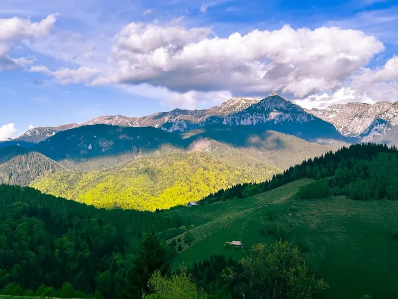
The Retezat Mountains Loop is a challenging multi-day trek through one of Romania's most spectacular and biodiverse national parks. This circular route, often referred to as the "Land of Blue Eyes" due to its numerous glacial lakes, offers a profound wilderness experience. Traversing rugged alpine terrain, it passes through ancient forests, across high mountain passes, and beside pristine glacial tarns, showcasing the raw beauty of the Southern Carpathians. The Retezat Massif is a geological marvel, home to Romania's highest peak, Peleaga, and a rich tapestry of flora and fauna, including the endangered brown bear and wolf. This trail is for experienced hikers seeking solitude, dramatic landscapes, and a true test of endurance.
- Distance: 60.0 km
- Elevation Gain: 3,500 m
- Duration: 4-5 days
- Difficulty: Challenging
- Best Time: July to September (summer months)
- Closest City: Petroșani
- Trailhead Access: Nearest airport: Sibiu (SBZ). From Sibiu, take a bus or train to Petroșani, then a taxi or local bus to Cârnic. Driving from Petroșani: Follow DN66 to Cârnic. Road is paved but can be narrow. Parking available at Cârnic. Trailhead GPS: 45.3833, 22.8833. No permits usually required, but check local regulations before hiking.
- Coordinates: 45.3833, 22.8833
Overview
The Retezat Mountains Loop is a demanding yet incredibly rewarding journey through the heart of Romania's Retezat National Park. This park, established in 1935, is a UNESCO Biosphere Reserve and a sanctuary for alpine ecosystems. The loop typically starts and ends at Cârnic, a popular access point, and can be completed in four to five days, depending on pace and acclimatisation. The trail navigates through varied landscapes, from dense, old-growth forests of pine and fir to vast, open alpine meadows carpeted with wildflowers in summer. The defining feature of the Retezat is its glacial topography, sculpted by ancient ice sheets, leaving behind over 80 glacial lakes, the largest and most famous being Bucura Lake.
The route ascends to several high passes, offering breathtaking panoramic views of the surrounding peaks, including the iconic Peleaga (2,509 m) and Retezat (2,482 m). Hikers will encounter a rich diversity of wildlife; the Retezat is one of the last strongholds for large carnivores in Europe. While sightings are rare and require caution, the presence of bears, wolves, and lynx adds an element of wildness to the experience. The trail is marked, but often rugged and steep, requiring good navigation skills and physical fitness. The accommodation options are primarily mountain huts (cabins) and, in some areas, designated wild camping spots, offering a true immersion in nature.
The Retezat Mountains are known for their dramatic weather shifts. Sunny summer days can quickly give way to thunderstorms, fog, and even snow at higher elevations. Therefore, preparedness for all conditions is paramount. The loop offers a genuine escape from civilisation, providing a chance to connect with nature on a profound level, surrounded by some of the most pristine mountain scenery in the Carpathians.
History and Cultural Context
The Retezat Mountains have a long history of human interaction, primarily driven by pastoralism and, more recently, by scientific and recreational interests. For centuries, shepherds have grazed their flocks in the mountain pastures, leaving behind a legacy of traditional practices and small, stone shelters. The Retezat Massif, with its unique glacial features and rich biodiversity, began to attract scientific attention in the late 19th and early 20th centuries. Botanists and geologists were particularly drawn to its diverse flora and the evidence of past glaciation.
The establishment of Retezat National Park in 1935 was a pioneering conservation effort in Romania, aiming to protect its unique natural heritage. This was one of the first national parks in the country, reflecting a growing awareness of the need to preserve wild landscapes. The park's designation as a UNESCO Biosphere Reserve further underscored its international importance for biodiversity conservation and scientific research.
The trails themselves have evolved from ancient shepherd paths and early exploration routes. The development of mountain huts, often built by the Romanian Alpine Club (Clubul Alpin Român) or other organisations, has facilitated access for hikers and mountaineers. The Retezat remains a vital area for ecological research, particularly concerning its large carnivore populations and its unique glacial lake ecosystems. The cultural context of the region is also tied to the nearby mining towns, such as Petroșani, which historically supported the local economy, though the focus has increasingly shifted towards ecotourism and conservation.
Seasonal Highlights and Weather Reality
The optimal season for hiking the Retezat Mountains Loop is from July to September. During these months, the weather is generally more stable, and the snow has melted from the higher passes, making the trails accessible and safer.
Summer (July–August): This is peak season. The alpine meadows are in full bloom, creating a spectacular display of wildflowers. Days are long, offering ample time for hiking. However, this is also the period when thunderstorms are most frequent, typically developing in the afternoon. Temperatures can range from pleasant in the valleys to cool at higher altitudes, with nights potentially dropping near freezing. Sandflies are not an issue here, but mosquitoes can be present in damper areas.
Early Autumn (September): This is often considered the best time to visit. The crowds thin out, the air is crisp, and the larch trees begin to turn golden, offering stunning autumnal colours. The weather can still be good, though the risk of early snow increases towards the end of the month. The lakes often reflect the vibrant colours of the surrounding foliage, creating picturesque scenes.
Late Autumn and Winter (October–June): The Retezat Mountains become a winter wonderland, but this is a period for experienced mountaineers only. Snowfall can be heavy and persistent, making the trails impassable for standard hiking. Avalanches are a significant risk. The mountain huts may be closed or have limited services. Access to higher areas requires specialised winter gear, including crampons, ice axes, and avalanche safety equipment, along with advanced navigation and snow travel skills.
Weather Considerations: Regardless of the season, mountain weather in the Retezat can change rapidly. Always be prepared for rain, wind, and significant temperature drops, even on seemingly clear days. Afternoon thunderstorms are common in summer and can bring lightning, heavy rain, and hail.
Recommended Itinerary
4-Day Retezat Mountains Loop Itinerary
Day 1: Cârnic to Gura Apei Hut / Poiana Pelegii
- Distance: 12-15 km
- Elevation gain: 800-1000 m
- Time: 5-7 hours
- Start at Cârnic (parking area, access via DN66 from Petroșani).
- Follow the marked trail (often red stripe or blue stripe) through dense forest, gradually ascending along the Râul depending on the chosen route.
- Possible destinations include Gura Apei Hut (a more basic shelter) or Poiana Pelegii (a large meadow often used for camping, with potential for wild camping if permitted and conditions are right).
- The initial part of the hike is a steady climb through mixed forest, offering a good warm-up.
- Arrive at your chosen accommodation/camping spot for the night.
Day 2: Gura Apei Hut / Poiana Pelegii to Bucura Lake Area
- Distance: 10-12 km
- Elevation gain: 1000-1200 m
- Time: 6-8 hours
- Ascend towards the higher alpine zone.
- The trail becomes steeper and more exposed as you gain altitude.
- Pass through alpine meadows and rocky terrain.
- The objective is to reach the vicinity of Bucura Lake, Romania's largest glacial lake.
- Several huts or designated camping areas are available near Bucura Lake (e.g., Bucura Hut, or wild camping spots if permitted).
- This is a challenging day with significant elevation gain, leading to spectacular views as you approach the lake.
Day 3: Bucura Lake to Custura / Gentiana Hut
- Distance: 10-14 km
- Elevation gain: 600-800 m, with significant descents
- Time: 6-8 hours
- Explore the area around Bucura Lake in the morning.
- Ascend to a high pass, potentially crossing near Retezat Peak (2,482 m) or traversing towards Custura peak.
- Descend towards another mountain hut, such as Custura Hut or Gentiana Hut, which are often located in scenic valleys.
- This day involves traversing high ridges and experiencing significant elevation changes.
- The views from the passes are panoramic, showcasing the vastness of the Retezat Massif.
Day 4: Custura / Gentiana Hut to Cârnic
- Distance: 15-18 km
- Elevation loss: 1000-1200 m
- Time: 6-8 hours
- Begin the descent back towards the trailhead at Cârnic.
- The trail will lead you through forests, gradually losing altitude.
- You may pass by other smaller lakes or streams on your way down.
- The final section is a steady downhill walk, often on forest tracks.
- Arrive back at Cârnic, completing the loop.
Alternative 5-Day Itinerary:
- Day 1: Cârnic to Gura Apei Hut
- Day 2: Gura Apei Hut to Bucura Lake
- Day 3: Explore Bucura Lake and surrounding peaks (e.g., Peleaga Peak), return to Bucura Lake area or a nearby hut.
- Day 4: Bucura Lake to Custura/Gentiana Hut
- Day 5: Custura/Gentiana Hut to Cârnic
Important Notes:
- Trail markings can vary in quality; a map and compass/GPS are essential.
- Hut accommodation should be booked in advance where possible, especially during peak season.
- Wild camping may be permitted in designated areas or outside the immediate vicinity of huts, but always check local regulations and park rules.
- Carry sufficient food and water, as resupply points are scarce.
- Be prepared for rapid weather changes.
Planning and Bookings
Book Your Trip
Everything you need to plan your journey
Accommodation
Find places to stay near Petroșani
Flights
Search flights to Petroșani
Essential Preparation
The Retezat Mountains Loop is a demanding trek that requires thorough preparation. Physical fitness is paramount; you should be comfortable hiking for 6-8 hours a day with a heavy backpack, including significant ascents and descents over uneven terrain. Familiarity with navigation using a map and compass or GPS device is crucial, as trail markings can be inconsistent or faded in places. Researching the specific trail conditions and weather forecasts immediately before your trip is vital. The closest major city for logistical support is Petroșani, which offers accommodation, food supplies, and transport links. From Petroșani, you will need to arrange transport (taxi or local bus) to the Cârnic trailhead. Ensure you have adequate travel insurance that covers hiking and potential mountain rescue.
Trail Accommodation
Accommodation in the Retezat Mountains primarily consists of mountain huts (cabins) and designated wild camping areas. It is highly recommended to book hut accommodation in advance, especially during the summer months (July-September), as capacity is limited.
Mountain Huts (Cabins):
- Examples: Gura Apei Hut, Bucura Hut, Custura Hut, Gentiana Hut. (Specific names and availability can vary; research current options).
- Booking Requirements: Advance booking is strongly advised. Contact the relevant mountain rescue service or club that manages the hut. Some huts may have online booking systems, while others require phone calls or emails.
- Facilities Provided: Typically include dormitory-style sleeping areas with beds (often mattresses only), a common room for dining, and sometimes basic kitchen facilities (e.g., gas stoves, but bring your own cookware). Running water may be available, but purification is recommended. Toilets are usually basic (pit latrines or composting).
- What's NOT Provided: Bedding (sleeping bags are essential), cooking equipment (pots, pans, utensils, fuel), food, electricity, charging facilities, hot showers, or Wi-Fi.
- Seasonal Availability: Most huts are open and staffed during the summer hiking season (roughly June to October). Outside this period, they may be closed, unstaffed, or only accessible to experienced winter mountaineers.
- Costs: Prices vary but expect approximately 50-100 RON per person per night for dormitory beds.
Wild Camping:
- Wild camping may be permitted in certain areas, often in meadows or designated spots away from huts. However, regulations can be strict, and it's essential to check with the Retezat National Park administration for current rules and designated zones. Always practice Leave No Trace principles if camping wild.
Required Gear
- Sturdy Hiking Boots: Waterproof, broken-in, with good ankle support for rough terrain.
- Backpack: 50-65 litre capacity, with a rain cover.
- Waterproof Jacket and Trousers: Essential for protection against rain and wind.
- Sleeping Bag: A 3-season bag (comfort rating around 0-5°C) is recommended, as nights at altitude can be cold.
- Navigation Tools: Detailed topographic map of the Retezat Mountains, compass, and a GPS device or smartphone with offline maps.
- Head Torch: With spare batteries, for use in huts and during early/late hiking hours.
- First-Aid Kit: Comprehensive kit including blister treatment, pain relievers, antiseptic wipes, bandages, and any personal medications.
- Sun Protection: High SPF sunscreen, sunglasses, and a wide-brimmed hat.
- Insect Repellent: Especially for mosquitoes in damper areas during summer.
- Trekking Poles: Highly recommended for stability on ascents and descents.
What to Bring
- Food: Sufficient non-perishable food for 4-5 days, including breakfasts, lunches, dinners, and high-energy snacks. Plan meals carefully as resupply is not possible on the trail.
- Water Treatment: Water filter or purification tablets, as stream water, while plentiful, should be treated.
- Cooking Equipment: Lightweight camping stove, fuel, pot, mug, bowl, cutlery, lighter/matches.
- Toiletries: Biodegradable soap, toothbrush, toothpaste, toilet paper, hand sanitiser.
- Warm Layers: Fleece or down jacket, thermal base layers (merino wool is ideal), warm hat, and gloves.
- Dry Bags: To keep essential gear dry inside your backpack.
- Personal Items: Camera, power bank for electronics, book or journal.
- Cash: For hut fees and potential small purchases, as card payment facilities are unlikely.
Permits
Generally, no specific permits are required for hiking the Retezat Mountains Loop for independent trekkers. However, Retezat National Park has regulations in place to protect its environment. It is crucial to be aware of and adhere to these rules.
Park Entrance Fees: While there isn't typically a daily entrance fee for hikers, there might be a small fee for vehicle access to certain points like Cârnic. Always check the official Retezat National Park website or inquire locally for the most up-to-date information on any potential charges.
Camping Regulations: Wild camping rules can be strict. Camping is often restricted to designated areas or may be prohibited within a certain distance of mountain huts. It is advisable to confirm these regulations with the park authorities before your trip. If camping near huts, you may be expected to pay a small fee or use the hut facilities.
Hut Bookings: As mentioned in the accommodation section, booking mountain huts in advance is highly recommended, especially during the peak season (July-September). This is not a permit requirement but a booking necessity to secure a place.
Research is Key: Before your trip, visit the official website of Retezat National Park (Parcul Național Retezat) or contact the park administration directly. They will provide the most accurate and current information regarding any required permits, fees, camping regulations, and trail conditions.
Other Activities in the Area
Beyond the Retezat Mountains Loop, the surrounding region offers several other attractions and activities:
- Peleaga Peak Ascent: For those seeking an extra challenge, a day hike to Peleaga Peak (2,509 m), the highest point in the Retezat Mountains, is highly recommended. This can be done as a strenuous day trip from the Bucura Lake area.
- Bucura Lake Exploration: Spend extra time around Bucura Lake, the largest glacial lake in Romania. Its stunning turquoise waters and surrounding peaks offer incredible photographic opportunities and a serene atmosphere.
- Scientific Research and Education: The Retezat National Park is a hub for ecological research. Visitors interested in biodiversity can learn about the park's flora and fauna, including its significant populations of bears, wolves, and lynx, through visitor centres or guided educational walks if available.
- Traditional Villages: Explore nearby traditional Romanian villages to experience local culture, cuisine, and hospitality. While not directly in the mountains, they offer a glimpse into rural life in the Carpathian foothills.
- Adventure Tourism in the Jiu Valley: The Jiu Valley, near Petroșani, has a history of mining. While this industry is declining, there are efforts to develop adventure tourism, including potential for activities like caving or exploring former mining sites, though these are separate from the Retezat hiking experience.
- Other Carpathian Hikes: The Retezat Mountains are part of the larger Carpathian range. For those who enjoy multi-day trekking, exploring other sections of the Southern Carpathians, such as the Făgăraș Mountains, offers further opportunities for challenging and scenic hikes.
Safety and Conditions
Pre-Trip Checks:
- Weather Forecast: Always check the mountain weather forecast for the Retezat region immediately before and during your hike. Websites like Meteo Romania or specific mountain weather services are invaluable. Be prepared for rapid changes.
- Trail Conditions: Consult the Retezat National Park administration or local mountain rescue services for the latest information on trail conditions, snow levels, and any potential hazards (e.g., landslides, fallen trees).
- Emergency Contacts: Save the numbers for local mountain rescue (Salvamont) and emergency services on your phone.
On the Trail:
- Navigation: Trails can be poorly marked or overgrown. Carry a map and compass and know how to use them. A GPS device or smartphone with offline maps is a valuable backup.
- Wildlife: The Retezat is home to bears, wolves, and lynx. While encounters are rare, be aware of your surroundings. Make noise while hiking (talking, singing) to avoid surprising animals. Store food securely in huts or while camping to avoid attracting wildlife. Never feed wild animals.
- Weather: Mountain weather can change drastically. Be prepared for rain, strong winds, fog, and cold temperatures, even in summer. Hypothermia is a risk at higher altitudes.
- Water: While glacial lakes and streams are abundant, always treat water before drinking to avoid waterborne illnesses.
- Physical Exertion: The terrain is challenging with significant elevation changes. Pace yourself, take regular breaks, and stay hydrated.
- Communication: Mobile phone signal is unreliable in the mountains. Consider carrying a personal locator beacon (PLB) or satellite messenger for emergencies.
- Hut Safety: Follow any rules posted in the huts. Be mindful of other hikers and share common spaces respectfully.
Emergency Procedures:
- In case of an emergency, stay calm.
- If possible, move to a safer location.
- Contact emergency services (Salvamont) if you have signal. Provide your exact location, the nature of the emergency, and the number of people involved.
- If you cannot contact help, stay put and try to signal for assistance.
Side Trips and Points of Interest
Peleaga Peak (2,509 m): The highest point in the Retezat Mountains. A challenging but rewarding side trip from the Bucura Lake area, offering unparalleled 360-degree views of the entire massif, including numerous glacial lakes and surrounding peaks. The ascent is steep and can be exposed.
Bucura Lake (Lacul Bucura): The largest glacial lake in Romania, situated at an altitude of 2,040 m. Its striking blue-green colour and dramatic mountain backdrop make it a central attraction. The area around the lake is often used for camping and is a hub for hikers.
Retezat Peak (2,482 m): The second-highest peak, offering a different perspective of the mountain range. The traverse between Bucura Lake and Retezat Peak is a popular route for experienced hikers.
Zănoaga Lake (Lacul Zănoaga): Another beautiful glacial lake, often considered one of the deepest in the Retezat. It's accessible via a trail from the main loop and offers a quieter, more secluded experience compared to Bucura Lake.
The Glacial Lakes: The Retezat is famous for its over 80 glacial lakes. While Bucura and Zănoaga are prominent, many smaller, unnamed tarns dot the landscape, each with its own unique charm and offering opportunities for quiet contemplation and photography.
Ancient Forests: The lower slopes of the Retezat are covered in ancient forests of spruce, fir, and pine. Hiking through these primeval woodlands provides a sense of timelessness and a connection to a wilder past.
Alpine Meadows: In summer, the high-altitude meadows burst with a vibrant array of wildflowers. These open expanses offer a stark contrast to the rugged rocky peaks and provide excellent opportunities for observing alpine flora.
Leave No Trace
The Retezat National Park is a protected UNESCO Biosphere Reserve, and preserving its pristine environment is paramount. Adhering to Leave No Trace principles is not just a guideline but a responsibility for all visitors.
Plan Ahead and Prepare: Research the park regulations, trail conditions, and weather forecasts. Pack appropriately for the conditions and carry all necessary gear. Know your limits and plan your itinerary accordingly.
Travel and Camp on Durable Surfaces: Stick to marked trails to avoid damaging fragile vegetation. If camping, use designated sites or camp on durable surfaces like rock or dry grass, at least 10 metres away from water sources and trails. Avoid trampling vegetation.
Dispose of Waste Properly: Pack out everything you pack in, including all food scraps, wrappers, and any other litter. Use designated toilets at huts. If wild camping, dig catholes at least 60 metres away from water, trails, and campsites, and bury human waste properly. Pack out all toilet paper.
Leave What You Find: Do not disturb or remove any natural objects, plants, or historical artefacts. The Retezat's beauty lies in its natural state.
Minimize Campfire Impacts: Campfires are generally discouraged or prohibited in national parks to protect the environment. Use a lightweight stove for cooking instead. If fires are permitted in specific areas, use existing fire rings and ensure they are completely extinguished before leaving.
Respect Wildlife: Observe wildlife from a distance. Never feed animals, as this can harm their health, alter their natural behaviours, and expose them to danger. Store food securely.
Be Considerate of Other Visitors: Keep noise levels down, especially in huts and campsites. Yield to other hikers on narrow trails. Respect the wilderness experience of others.